Showing posts with label Lake Champlain. Show all posts

Friday, February 13, 2026

Lake Champlain Has Officially Frozen Over

Satellite view of Lake Champlain today show
no sign of open water on the lake today, so
it has been officially declared frozen over 
 The National Weather Service in South Burlington this afternoon officially declared Lake Champlain frozen over. 

It's the first time that's happened since March 9, 2019.

The National Weather Service notes that "completely iced over" is subjective. There might still be some cracks and little fissures or holes out there that satellites, drones and airplanes didn't or can't notice.

I personally thought the lake would freeze last weekend or Monday during a cold wave that sent temperature into the upper single numbers and teens below zero.  

But there was probably a bit too much wind stirring the small areas of open water to make the lake freeze.

Overnight and early this morning, we had clear, calm weather. The temperature at Burlington reached a low of 1 above around dawn today. That weather was the charm. 

Our February 13 Lake Champlain freeze date this year is about the time it usually gets iced over. At least in the years it does freeze,

Usually, in January it hasn't been cold enough long enough for a frozen lake. In March, an increased chance of a thaw or just a higher, warmer sun angle can prevent the lake from freezing.

But there's always exceptions. The earliest freeze over was on January 8 1868 and the latest was on March 26, 1894.

I - and pretty much everybody else - are suspicious of those dates. Nobody had planes, drones or satellites back in the 19th century. So there was probably some open water way out there on both those early and late dates.  It's just nobody could see them from shore. 

No lake ice is completely safe. The broad lake is particularly risky. There's certainly areas of thin ice, cracks or weak areas cause by pressure building between areas of ice. So please don't walk from Burlington to Plattsburgh, please.  

That said, Lake Champlain has had little ice on it in recent years, so it is nice to go out onto relatively safe areas of ice to check out what has really become another world. 

In at least part due to climate change, Lake Champlain freeze overs have become much less likely. Since 2000, the lake has only frozen over nine times. In the mid 20th century, in the thirty years between 1940 and 1969, the lake froze over 20 times. 

 Lake Champlain might not stay completely frozen for long. By early next week, thawing and increasing winds could poke holes in the ice.  

Thursday, February 5, 2026

Enjoy The Semi-Heatwave: Vermont/Eastern U.S. Still In For Brutal Weekend Arctic Blast

Satellite photo from early this afternoon shows a little 
open water on Lake Champlain still. It might freeze
over tonight with calm winds and lows near 0. If not
the next, far more brutal cold wave over the weekend
and Monday should do it. 
Editor's Note: I'm recovering from yesterday's' eye surgery, which went well, so I might be posting at odd times or not as frequently as usual for awhile yet. We apologize for the inconvenience. 

Wow, we almost got up to normal in Vermont temperatures in Burlington yesterday. The average temperature was 20 degrees, which was just half a degree below normal. We haven't had a warmer than average day since January 23. 

As of today, we've had 15 consecutive days in Burlington that never got above freezing. That's nowhere near our longest stretch on record, which was 51 days from December 22, 1976 to February 11 1977,

We're not even that close to getting into the top 10 list for consecutive subfreezing days which is 29 days, set on four different occasions must recently from January 5 to February 3, 2004.

Even so, we've got quite a few days to go without any thawing, and there will be a brutal Arctic blast thrown in for good measure. 

Today, as you have been able to tell, is nice. It's been in the 20s this afternoon, the sun is out, who can complain? 

Satellite photos this afternoon still show a fairly large area of open water right in the middle of Lake Champlain but it still could freeze overnight. Ice forms best on the lake when it's at least near or a little below zero and there's calm winds. Wind would push the ice around and break it up. We're expecting exactly those conditions tonight. 

We'll find out tomorrow whether the lake actually freezes or not. Friday will be another nice day with a fair amount of sun and temperatures getting back into the low and mid 20s. Still vaguely cooler than average for this time of year, but not bad. 

BUT THEN........

Our long-advertised brutal Arctic cold front will bring one to three inches of light, fluffy snow, with a bit more in the mountains and maybe the far northern Champlain Valley late Friday night and Saturday morning. But that's not what we're worried about.

The air we're getting is coming is a straight shot from Siberia. It went up and over the North Pole and is blasting its way toward us in New England. Aren't we lucky?   

The big temperature crash is coming a few hours later than we saw in earlier forecasts. Instead of hitting on Friday evening, the real plunge in temperatures won't come until a little before dawn on Saturday. High for the day will be in the teens in the hours just after midnight, so we won't have a rare day in which the high is below zero.

But don't you worry if you want an unbearably cold Saturday, we got ya! By mid to late morning Saturday and continuing through the afternoon, the temperature will head toward subzero readings.  

Winds will gust past 30 mph. On top of the dangerously cold air out there, the fluffy snow that is on the ground now and is coming will blow around a lot. 

Yuck! This might well be the cruelest cold we've had our winter.

Already, an extreme cold watch is in effect for wind chills as low as 35 below zero from Saturday morning through Sunday afternoon.  Extreme cold watches, along with winter weather and high wind alerts cover most of the northeastern United States as we all gear up for a rough weekend. 

Parts of North Carolina had a little more snow last night, so they are once again dealing with icy patches there.

It's still unseasonably cold in Florida, and a freeze warning is up again for the northern part of the state tonight. However, most fortunately for them, the intense cold wave that's hitting the Northeast this weekend will not hit Florida much. No hard freezes are likely in Florida after tonight. 

Back here in Vermont, the wind will die down slightly Saturday night to 10 to 20 mph hour, but the temperature will keep going down as well. By dawn, it will be in the upper single numbers to mid-teens below zero.

Sunday  I supposed will be better, but that's not saying much. The wind should gradually get lighter. The sun will probably drive afternoon temperatures into the single digits above zero for a few hours.   But it will be right back down well below zero Sunday night and Monday morning 

The AWESOME news is this might be the last horrible Arctic spell for awhile. The weather pattern is changing just enough so that new blasts of Arctic air won't be nearly as intense next week and beyond. 

That's not to say that this will be the last subzero cold of the winter. It can get below zero well into mid-March. But we are probably in for at least a semi-break.

It'll still be cold Monday and to a lesser extent Tuesday, with subzero mornings both days. But the second half of the week will at least be closer to normal. 

We don't have a lot of details on the second half of next week because the computer models are all over the place on that one.  Which means we also don't know when the next snow will come after whatever falls Friday night and Saturday. We'll probably have nothing until at least next Wednesday.  

Wednesday, February 4, 2026

A Couple Reasonable Vermont Days, Then Gusty Icebox

EDITOR'S NOTE: I'm having emergency eye surgery today. I will be fine, but you'll notice I'm posting infrequently over the next few days. I apologize in advance for being MIA
Another view of frozen Lake Champlain on Monday 
Photo taken at St. Albans Bay. Although parts of the
lake are solidly frozen, other parts still have weak
and thin ice. Be careful out there! 

We in Vermont have a couple more days of reasonable weather before the bottom drops out again and we freeze our tushes off. 

It was nice and toasty Tuesday with highs again mostly in the 20s. Burlington reached a high temperature of 30, so it was the warmest day since January 22. 

By the way, if you're venturing out onto lakes, be careful.  The ice out there  can still be dicey, despite the recent cold weather. That's especially true on Lake Champlain, which still has some open water out in the middle. 

Vermont State Police said five skaters got stranded on Lake Champlain Tuesday near Charlotte when a section of ice they were on broke free and started to float away. 

The skaters were about 675 feet offshore of Charlotte, Vermont. Rescuers used an inflatable boat to cross 200 feet of open water to take the skaters one at a time back to stable ice. From there, the skaters were able to walk to shore. They're fine. 

But, it's a sign we shouldn't go too far out onto Lake Champlain. Let's just say don't walk from Burlington to Plattsburgh or anything stupid like that. 

FORECAST:

We've got just a minor cool down today and tomorrow, but nothing extreme. At least not yet. 

You'll want to be a bit careful driving to work or school this morning, especially in northern Vermont, as some snow showers are passing through.  

So far, the snow didn't look too heavy or particularly widespread on radar before dawn today.  I expect there might be a few slick spots on the roads, though. 

But it will pretty much clear out this afternoon. It'll be cooler than yesterday with highs near 20, which is still not bad for February. A tiny piece of Arctic air will sneak in Thursday night, dropping temperatures to near 0 again before we recover to the low 20s again Friday.

Then we get blasted by a strong cold front Friday night with a burst of snow, maybe amounting to an inch or two. By Saturday morning, temperatures will be in the single numbers and still falling.  Some of the colder places could fall below zero by late morning. 

It's going to be a frigid weekend, with lows below zero through Monday morning at least. Next Tuesday morning could be below zero as well. Those temperatures in single numbers during the day Saturday will repeat themselves Sunday 

Howling north winds will send wind chills far, far below zero, especially on Saturday. Sunday will have some north breezes, too,so the chill will be an issue then. But it probably won't be quite as bad as Saturday.  

The wind might finally die off Sunday night, which would drop our temperatures into the teens below zero in many areas.

One saving grace is that the Arctic cold this weekend won't be quite as intense as some earlier forecasts I saw. Also, the wind might also not be as strong or long-lasting as those earlier forecasts. Even so, it'll be a brutal weekend out there. 

We're hoping temperatures get close to normal again by midweek. And we're still banking on a weather pattern change that would put us up for at least several days after midweek in which temperatures will be near or even a tad above normal. It won't be springtime, but at least it might be tolerable! 


Tuesday, February 3, 2026

After Vermont 26 Degree Monday Heatwave, Below Zero Again This Morning. If You Want Super Arctic Cold, It's Coming

The sun getting ready to set over Lake Champlain, as
seen from St. Albans Bay Monday after a bright, 
bluebird winter day. 
Another round of subzero cold Monday and this morning has very nearly frozen over, despite an afternoon "heat wave" that brought temperatures into the 20s.  

Lake Champlain might have managed one last lake effect snow of the season a couple days ago, on Sunday. 

There was enough open water, combined with just the right atmospheric set up, for a light stripe of snow extending from about Burton Island down to about Bridport. A dusting to up to inches of snow fell in this band.

Time lapse video on  appeared to show a wide area of open water filling in with ice in calm, cold weather Monday morning; 

But it was all just thin scrim of ice that broke into chunks. There was still a fair amount of open water out there.  We'll see what the predawn chill did today on the lake. 

The temperature in Burlington Monday rose to 26 degrees ending a nine day streak where the temperature never got to 20 degrees. That's the longest such stretch of such cold weather since a 12-day stretch of sub-20 degree weather January,  2005

Now that we're into February, the sun is starting to get higher in the sky and
stronger. With light winds, yesterday's bluebird skies and sun  felt strangely comfortable out there for a change. 

Nothing lasts forever, though.  Especially anything that feels remotely mild. So, with clear, moonlit skies last night, we were back below zero this morning. 

It still looks like we will make it up into the 20s today, tomorrow and maybe, maybe Thursday and Friday. We also might get a bit of snow tonight  Wednesday, but it shouldn't amount to much. Maybe a dusting in the valleys, o an inch or two in the northern Greens.

Obviously we can't stay balmy forever.  Highs in the 20s is way, way more than we deserve.  (CHECK)

With that, we will get right back into the deep freeze Friday and the weekend. It'll come in Friday night with maybe an inch or two of snow. You will really notice the chill starting Friday night and over the weekend. 

My early guess on the weekend cold is it might be the roughest in the series yet. Current have forecasts have highs in the single numbers and lows in the single numbers and teens below zero. 

That's similar to the depth of the past couple of cold waves. The difference this time will be the wind. This time, gusts are likely to blast at us from the north over the weekend. These won't just be  light, frigid breezes. It'll be a bonafide wind.

The wind chills will make the upcoming cold wave worse and more dangerous than the weather we've seem recently

A WARMER CHANGE?

We might get a little bit of additional relief after this next cold wave passes next week. 

I wrote a few days ago that there might be a change in the weather pattern after mid-month. I am getting more optimistic that we might at least temporarily turn milder later in February.

If NOAA's eight to 14 day outlook is to be believed, the big high pressure over Greenland that forced cold air southward recently is on the move. It looks like it will shift a bit toward northeast Canada while expanding southward a bit. 

That, and a possible slight dip in the jet stream over the western United States would make the jet stream flow more west to east across the United States. Instead of Arctic air coming right at us from northwest Canada, some milder Pacific air would at least occasionally mix into the air over us. 

That's not guaranteed just yet, but it's the best sign of a warmup I've seen yet in this Arctic siege.  By warmup, I don't mean beach weather. It's February. It'll still be chilly most days later in the month.  Just not way below zero cold. 

The new weather pattern would also probably increase the chances of storms with snow or mixed precipitation. It won't be all rainbows and sunshine and puppy dogs and fairy dust. 


Sunday, February 1, 2026

Lake Champlain Ice Watch: Not Entirely Frozen Yet!

Visible satellite photo of Vermont and surrounding areas
this afternoon. Clear skies allowed us to see the ice 
situation on Lake Champlain. The dark blue area is
where the lake is not frozen yet. 
 Nope, Lake Champlain is not completely frozen over yet. 

It got clear enough for visible satellite photos to give us a good view today.  As you can see in the photo here, there's a large blue patch in the middle of the lake. That's open water. 

The northern half of the lake is solidly frozen. It's been that way for days or weeks, depending on exactly where you are. The narrow, shallower southern end of the lake is frozen over, too.

If the lake completely freezes, it will probably be at least a few days before that happens. More ice will very likely get manufactured tonight, since temperatures are forecast to go slightly below zero. But a light breeze will also probably continue all night, so that might slow the process down. 

Temperatures will moderate into the low to mid 20s by day and single digits to around 10 above until the end of the week. I'm guessing that also won't be cold enough to completely seal off the lake. 

Another blast of Arctic air is due next weekend, and that'll bring daytime highs back down to the single numbers and overnight lows well below zero.

We'll see whether that will be enough to finally freeze over the lake for the first time since 2019. 


Saturday, January 31, 2026

Frigid Weather Drags On; Lakes Freezing Up

Screen grab from the WCAX Echo Center web cam from
this morning. There's a lot of ice on Lake Champlain now.
If you look carefully you can still see open water far offshore 
 It's frigid again today here in Vermont and through the rest of the eastern United States as the worst siege of winter weather in years, maybe decades rolls on with little sign of a break. 

A historic nor'easter and cold wave in the Southeast was just cranking up toward full speed this morning. 

Up here in Vermont, nothing exciting. Just unrelenting, tiring cold. 

LAKE CHAMPLAIN

Lake Champlain is rapidly freezing up. This week, the huge expanse of open water we saw at the start o the week is now a relatively small hole of open water way out in the middle. 

On Wednesday, the lake was pretty much frozen just to the Burlington breakwater, which is about 1,000 feet offshore. By Thursday, the ice went all the way out to Juniper Island, which is three miles offshore from Burlington.  

Shelburne Bay had some open water Wednesday. By Thursday the bay was entirely iced over. 

The cold weather yesterday and today obviously manufactured even more ice. Still, it will take awhile for the middle of the lake to freeze over because it's more exposed to the wind. Also, it's the deepest part of the lake, so relatively warmer water would upwell from below, which would at least delay a freeze over. 

WCAX noted that in all but one winter with a January weather like this year's the lake froze over completely if February's temperatures were below normal.

Spoiler: February's temperatures will be below normal as we see no real sign of a let up in the cold through the middle of the month. Sure, some days will be only a little cooler than average. But other days will be bitterly cold, at least as forecast look now.

It Lake Champlain entirely freezes over this winter, it would be the first time since 2019 that it's happened. The lake has only frozen over eight times since 2000

GREAT LAKES

The Great Lakes are freezing over, too, Lake Erie was 95 percent frozen as of yesterday. That will mostly shut down the lake effect snows in and south of Buffalo for the season. (Even when Lake Erie is frozen, some moisture gets through the ice, so there could still be some light lake effect in towns south Buffalo, like Dunkirk and Hamburg.

Lake Erie is much shallower than the other Great Lakes, which is why it freezes over so readily. 

Deep Lake Ontario had the least ice, but it was still 23 percent frozen over. About a quarter of both Lake Michigan and Lake Superior had iced over. A little more than half of Lake Huron was frozen.

The ice on those lakes will continue to expand, as no thaws are headed toward the Great Lakes. 

VERMONT FORECAST

No thaws are coming to Vermont, either. 

Oh sure, today will be hotter than yesterday. But not by much. The high temperature in Burlington yesterday was 7 degrees. The forecast high today is 12. After another subzero night tonight, Sunday's temperatures will be similar to today's 

Vermont is still set up for a "heat wave" this coming week. It now looks like every day for most places in the Green Mountain State should reach the low to mid 20s. Overnight lows will be within a few degrees either side of zero. That's just a little colder than average.

But signs point toward the deep chill returning by next weekend. Lo ng range forecast have us below zero again for at least a few days starting about a week from now.

Between now and next weekend, we'll have very little if any snow. Cold waves like this are dry, so it's hard to get any substantial snowfalls in this weather pattern.  

Oh, sure, we'll have some flurries from time to time, but it'll never amount to much. We had some flurries this morning. That was actually produced by moisture from all the way up in the Labrador Sea. The air flow has been coming from that direction overnight and this morning. 

Those flurries could continue here and there for the rest of the day.  

Monday, January 19, 2026

Will Lake Champlain Freeze Over This Winter

There was still a lot of open water on Lake Champlain
 as of Sunday as this photo shows. But an expected
long, intense cold spell could eventually make
the lake freeze over for the first time since 2019.
 We've got a LOT of cold air headed toward the eastern United States, including here in Vermont. 

That frigid air looks like it might last quite awhile, too. Does this mean Lake Champlain will freeze over? Possibly, if the chill lasts long enough. 

If Lake Champlain does completely freeze over, it'll be the first time it's happened since 2019. In 2022, it came this close to freezing entirely, but there was always at least aa small hole of open water in the lake that winter. 

As of Sunday the huge expanse of the broad lake was ice-free. Bays, estuaries and coves were frozen, as they almost always are this time of year. But even inside Burlington's breakwater, there was no ice. After a warmish early January, we'll need a brutally long cold wave to ice over this lake. 

Such a cold wave seems to be a distinct possibility. 

It's not at all odd to have open water in Lake Champlain during mid-January.   Typically, if the lake turns into wall to wall ice, it doesn't happen until the very end of January or in February. There's been a few years in which the lake didn't freeze until March.

There's Lake Champlain freeze over data dating all the way back to 1816. But back in the 1800s and early 1900s, there were no planes flying over the lake to confirm it was entirely frozen. I imagine some historic "freeze overs" were actually only close, but no cigar.

After 1930, I could only find two years - 1977 and 1981 - in which the freeze over hit before today's date. 

If the lake doesn't freeze over this year, it would tie the record for most consecutive years of winter open water on the lake. The only other time six years went by without a complete freeze over was 2008-13.

Climate change is making it harder to freeze Lake Champlain. Since 2000, the lake has only frozen over eight times. It used to be more frequent than that before the world started substantially warming up

COLD FORECAST

The eastern third of the United States will be taking a break from that climate change warmth over the coming days and weeks. 

This will be a widespread, intense cold wave stretching from the northern Plains to New England and down into the northern Gulf Coast states. 

Locally here in Vermont, it still looks like most of this week won't be that bad. It'll certainly be cooler than the weekend was, but still pretty reasonable for a Vermont January. 

We'll get an initial taste of the cold tonight through tomorrow night. Highs Tuesday will only be in the teens, and it'll get close to zero in some towns Tuesday night .

Lake effect snows will go gangbusters this week
with an area south of Watertown, New York
expecting three to four feet of snow by Wednesday.
We'll briefly warm into the 20s for highs Wednesday and Thursday before the bottom drops out of everyone's thermometers.

In Vermont, and throughout the Northeast, it'll be an old fashioned cold wave. 

By that I mean it will be reminiscent of the long Arctic spells we used to see in the 1970s.  In recent decades, intense cold snaps were hit and run affairs. They'd blast in with their intense chill, then with a day or two, it was over.

This one looks to arrive this coming Friday and last perhaps for nearly a week. That means a long stretch of "high" temperatures near 0 or, if we're lucky the single numbers above zero. Each night will go below zero with some of those nights far below zero. Like teens and 20s below

At least that's the way it looks as of this morning. There are always changes to the forecast as we get closer to an event, and this is no exception. 

Frigid weather regimes like the one we're entering are usually quite dry, and that will be the case here. Remember, warm air can hold a lot of moisture. Bitter cold air holds very little. So, at most, we expect a few snow flurries from time to time in the valleys, and slightly heavier snow showers in the mountains. 

The next chance for any accumulating snow is when the cold front introducing the super cold air approaches us toward the end of the week. There's a chance of a few heavier snow showers or snow squalls around Thursday, but we're not too sure about that yet. Even that would only give us an inch or two of snow. 

The exception to the very little snow rule will be downwind from the Great Lakes. 

In New York, Lake Ontario will help produce the biggest monster snows. The infamous Tug Hill region south of Watertown could have four feet of new snow by Wednesday morning. 

Lake Erie freezes over more quickly than Lake Ontario, because it's much shallower. Since ice is forming on Lake Erie, the snow belts south of Buffalo, New York won't be quite as bad as the Tug Hill region. Still, up to two feet of snow could come down in areas near Lake Erie.

I don't have any information yet on how the lake effect snows will work when the real cold air arrives next weekend. 

I don't see any signs of any balmy weather coming to the Northeast anytime soon. The best I can give you is that the chill might ease off somewhat by the time we get into February. 

 

Sunday, September 14, 2025

They've Already Canceled Our Next Shot At Vermont Rain

Read it and weep. Rainfall prediction map for the
next 7 days has nothing in and around Vermont. 
Meanwhile, torrential rain falls on the fishes
off the East Coast, and the Midwest gets
a good soaking. None of that is heading
in our direction, unfortunately. 
As expected, nothing more than sprinkles fell on a few spots last night, and many of us stayed completely rain free. One of the worst droughts in Vermont history continued to deepen. 

Some forecasts had a chance of isolated showers today, but that doesn't look like it's going to happen. Worse, our next chance at any rain, which was hoped for toward the end of this week, is now evaporating. 

It seems like this drought is never going away. 

Things are getting ridiculous. I was digging in a client's garden yesterday. Digging down a foot, I was still getting dust. One of my spruce trees has some wilted needles. I've never seen anything like that before. 

The forest fire danger in Vermont remains high and will stay that way for at least the next week. 

The Lake Champlain lake level as of yesterday was 93.26 feet.  That's down a whopping five feet since early June.

The current take level isn't actually the lowest it's ever been this time of year, but it's close. (It was at 92.71 feet in mid-September, 1941). Lake Champlain water there continues to slowly recede and is now within shouting distance of its all time lowest level, 92.13 on November 23, 1908.

Lake Champlain normally reaches its lowest level in late autumn. So if this drought continues, we could approach or break the record for its lowest level.   As it is, boaters have been hitting shoals and reefs that are now much closer to the water's surface than they once were.

Both 1908 and 1941 were among Burlington's top five driest years on record, so the low lake levels then aren't surprising. 

I doubt this year will be among the top driest ones because the first half of 2025 was relatively wet. Burlington has had 25.1 inches of rain so far this year. If we get about an inch and a half or more of rain by New Year's Eve, it won't be one of the driest years. 

We should manage that amount of rain by then. Gawd, I hope so. 

THE FORECAST

None of that rain is coming anytime soon. Strong  high pressure is coming in now to replace the other strong high pressure that kept us dry last week. This new high pressure will pretty much stall over us most of this week. 

This one is warmer than the last, so we'll have a bit of a summer redux most of this week.  The dry weather system that went though early this morning was a cold front of sorts, so today and tomorrow will have similar weather to what we've been having. That means highs in the low to mid 70s, lows in the 40s to low 50s. 

Tuesday through Thursday will turn into a bit of a summer redux. Many of us will see highs poke up to near 80.  It's dry out there, and that could lead to surprisingly warm afternoons. I wouldn't be surprised if a couple of those days reach the mid-80s. 

A stalled storm near the Mid-Atlantic coast could end up throwing some high clouds our way, which might limit high temperatures a little. But alas, that storm won't send any rain clouds our way, either. 

It had been hoped the next cold front around this coming Friday would come in from the west. That would have allowed some moisture to flow up from the Gulf and give us a little rain. Nobody anticipated much, but a little bit might have been nice.

Now, it's appearing more likely that another mostly dry cold front will come in from the north instead. That means we'd get nothing more than scattered sprinkles on Friday. .This is five days away, so things could turn wetter again, but I'm doubting it at the moment. 

All we'll get out of this is another strong, slow moving high pressure system. The late week one will be a somewhat colder one.  It will be hitting in the second half of September after all. So by Friday night, and maybe Saturday night, we'll have to be on the lookout for scattered frost. 

I'll update that when we get closer to the event. 

Longer range forecasts have gotten slightly more encouraging, but not encouraging enough. Long range forecasts for the roughly last ten days of the month indicate near normal precipitation, which is better than nothing. 

Even longer range forecasts, which admittedly are not always that accurate, give us equal chances of above or below normal precipitation into the first half of October.  However, the overall weather pattern does favor a warmer and drier than average autumn for us.

Thursday, August 28, 2025

Vermont Drought Expanded Over The Past Week, To Nobody's Surprise

Drought (orange shading) covers mostly central
and eastern Vermont as of this week. The
rest of Vermont in yellow is regarded
as abnormally dry.
The latest weekly U.S. Drought Monitor, issued this morning, shows drought expanding here in Vermont, with those drought conditions more or less holding steady in the rest of the Northeast. 

Last week, 35 percent of Vermont was categorized as being under moderate drought, covering mostly the Connecticut River Valley and central Vermont.  

This week, 54 percent of the Green Mountain State is in drought. It has expanded into the central and southern Champlain Valley and a greater portion of the Northeast Kingdom than last week.

As of this morning, about 324,000 of Vermont's 648,000 or so residents are living in drought conditions.

All areas of Vermont not officially in drought are listed as "abnormally dry" which means they are on the verge of drought.

There's plenty of other evidence of drought in Vermont.  The top one meter layer of soil in much of Vermont is among the driest on record for this time of year. 

Lake Champlain is at its lowest level in decades for this time of year. The low level can increase algae blooms. But on the plus side, the low water can expose invasive aquatic plants and kill them, which would help the overall ecosystem. 

River levels across the state are remarkably, low, too. 

ELSEWHERE

Rivers in Vermont are quiet low due to drought, like
in the Missisquoi River shown here in Enosburg
Falls, Vermont this past Sunday. 
In New Hampshire, moderate drought conditions were about the same as last week, says the U.S. Drought Monitor,  covering all of that state except the extreme south.

 In New York, a new drought area appeared this week in parts of the eastern Adirondacks and St. Lawrence Valley. 

The moderate drought grew more extensive in Maine, now extending much further inland from the coast. 

It now covers all of central and southern Maine, or just under two thirds of the state. Severe drought continues along much of the seacoast. 

FORECAST

As I mentioned this morning, the best rains for the next couple of days should hit northwest New York and sections of Maine. Both areas should receive at least three quarters of an inch of rain.

Here in Vermont, total rainfall for the next week should only be about 0.1 south to 0.3 inches north, with locally slightly higher amounts northwest and in the northern Green Mountains. That's well short of the inch of rain per week we'd like in normal times, and 1 to 2 inches per week we'd need to start getting out of the drought 

Almost all of the meager rain we're expecting in Vermont will come Friday and Friday night, with maybe a tiny bit more on Saturday.

Long range forecasts into the middle of September lean slightly toward a bit higher than normal rainfall around Vermont, but I'll believe it when I see it.  

Tuesday, March 11, 2025

Weird Vermont Temperature Contrasts A Hallmark Of Early Vermont Spring

Traffic camera image from Route 7 in Bennington Monday
shows no snow on the ground, part of the reason why
temperatures were able to rise to 56 degrees there. 
 Whether or not you had a true springlike day in Vermont Monday really depending on where you were. 

Down in places like Bennington and Brattleboro and Springfield, temperatures under sunny skies reached the mid-50s so spring was definitely in the air. 

Up by the Canadian border, not so much. Highs barely struggle into the mid 30s in some towns, and the few inches of snow that fell Sunday night didn't entirely melt. 

In between the two extremes, the north and the south, Vermont had a pleasantly enough mild March day, but it wasn't hard core spring. 

These kinds of weird temperature extremes in the Green Mountain State happen frequently in the late winter and early spring. You're going to see a little more of that today, too.

MONDAY WEIRDNESS

Part of the reason there were such temperature contrasts in Vermont came up in a post I filed last week.  . This time of year, frigid air - lingering winter - often stays firmly in place over the vast frozen forests and lakes of central and northern Quebec. 

If winds are light northerly, a thin layer of that cold air can bleed southward into far northern Vermont, so places like Highgate and Alburgh and St. Albans and Newport can occasionally get that frigid Quebecois feeling in early spring. 

That's what happened Monday. Newport only managed a high of 36 degrees Monday. 

Meanwhile, daytime temperatures, especially on sunny March afternoons, depend greatly on what's on the ground. 

Still a good amount of snow on the ground around
my house in St. Albans, Vermont Monday, part of the
reason why high temperatures never got out of
the low 40s during the afternoon.

Bare ground absorbs the sun's heat, and thus warms the air in the lowest couple thousand feet of the atmosphere. Those places would be noticeably balmier than places that are snow-covered.

There's pretty much no snow left on the ground around Bennington. So, the sun was able to heat things up nicely, which is a big part of the reason why high temperatures there on Monday was 56 degrees.  . 

Southeastern Vermont, around Brattleboro and Springfield, does still have some snow on the ground, but that snow is thin with plenty of bare spots  A northwest wind Monday also helped the air warm up. 

When the air flows down the slopes of mountains, in this case the southern Green Mountains, it compresses. Compressing air tends to warm up. Which meant the valleys of southeast Vermont also enjoyed some mid-50s  in the afternoon

Central Vermont was in a sort of unaffected middle. There's still plenty of snow on the ground in most of the area between Route 4 and Route 2. So the sun's heat reflected off the white snow cover. Which means it couldn't get quite as warm as it would have with bare ground. Also, some of the sun's energy went into trying to melt some of the snow rather than heat the atmosphere. 

However, that cold air from Quebec wasn't able to bleed southward all that much, so none of that Canadian chill could make it as far south as Route 2.  

The end result was a happy medium with highs well into the 40s. Montpelier had a high temperature of 46 degrees Monday. It probably resulted in a decent sap run in the sugar bushes, so we can't complain about that. 

TODAY

Strong south to southwest winds will briefly bring temperatures well up into the 50s to near 60 statewide.

An exception to the warmth will be right along the shores of Lake Champlain. Those southwest winds will pick up the chill from the icy waters of the lake and blow it ashore Places like Burlington's Waterfront Park will be stuck in the 40s at best for most of the day. Meanwhile, communities a few miles inland from Lake Champlain will be flirting with 60 degrees this afternoon.  

These lake breezes will often keep the immediate shore of Lake Champlain cooler than other areas well into early summer at least. 

Large scale storm systems are still strong this time of year too, so those bring sharp changes in temperature. 

A cold front will turn our balmy Tuesday of near 60 degree weather to a subfreezing shiver fest for Wednesday afternoon. Then, we're still expecting that massive storm in the Midwest to pump us right back up into the 60s again this weekend.

Those are the typical wild temperature gyrations we expect out of a March and April in Vermont.   As always, expect a wild ride and some surprises as we move through the first part of spring. 

Saturday, August 3, 2024

Wannabe Debby, Florida, Heat, Humidity, Vermont And You

Satellite view of what will become Tropical Storm
Debby as it was just starting to organize near Cuba
on Friday. It poses a threat to Florida in the coming days. 
 The heat drones on here in Vermont, where Burlington on Friday had its 13th day this summer with temperatures in the 90s. 

It was still above 70 degrees at dawn today in Burlington, the fifth consecutive morning of such stuffy conditions. 

People aren't getting much relief from Lake Champlain, either. We've had so many warm, muggy days and nights that the water temperature is hovering around a record high of 80 degrees.

  If the lake were an ocean, that would be warm enough to sustain a tropical storm or hurricane. 

No tropical storms here in Vermont. Scattered tropical showers over the next couple of days, maybe, but no tropical storms or hurricanes. 

Not so in Florida, which is under the gun from what I am for now calling Wannabe Debby.  It's a tropical depression that was just south of Cuba this morning.  It's organizing into what forecasters widely expect to become a full-fledged tropical storm by later today or tonight, and then they would name it Debby. 

It's expected to move generally northward, past Cuba and into the very warm waters of the eastern Gulf of Mexico. That will allow this thing to strengthen pretty efficiently and become a tropical storm or even possibly a Category 1 hurricane by the time it reaches northwestern Florida, probably on Monday. 

That'll open up swaths of Florida to coastal storm surges, wind and especially inland flooding. 

Wannabe Debby will probably slow down its forward motion as it passes through the southeastern United States early next week. That'll prolong the rain and intensify any flooding that goes on. 

It's also unclear what will become of Wannabe Debby once it reaches the Southeast. A trough of low pressure - the same one that promises to eventually clear out the ugly humidity in Vermont, could lift it northeastward, eventually passing just off the New England coast (probably, hopefully, too far east to give Vermont much trouble with rain)

Or, the trough of low pressure could entirely miss Wannabe Debby, leaving it behind to meander aimlessly somewhere near the Southeast coast. We'll just wait and see on that one.

VERMONT EFFECTS

Damage from a microburst in Colchester Vermont that
occurred this past Tuesday. There could be isolated
damaging microbursts in Vermont Sunday, but those
instances should be few and far between
So far at least, signs mostly suggest that Wannabe Debby won't be our problem here in Vermont. But the way this summer's going,  you never know, so stay tuned to local forecasts.

For now, we're stuck with the humid, icky weather through Monday morning at least. There was some spotty rain around this morning, but it didn't amount to much.

As usual in this kind of weather, some scattered showers and thunderstorms will develop this afternoon. They will be relatively few and far between, but of course any that do develop could stir up some locally torrential downpours. 

Sunday has a better chance of scattered storms, but again, not everybody will get 'em. Coverage of storms should be greater than it will be today.  There could be some isolated microbursts from some of these storms. Those can cause small swaths of pretty serious wind damage, like what happened in Colchester this past Tuesday.

The vast majority of us won't see anything like that, but a couple small spots might. 

Isolated instances of flash flooding are again possible, too, but it shouldn't be anything widespread. 

That long-awaited cold front should slowly limp through Vermont Monday with more showers.  It's still looking like we'll finally be into the much cooler, drier air by Tuesday and that would continue through the week. 

I have to wonder, though, whether Wannabe Debby will allow that front to progress very far south and east.  If that Wannabe Debby hangs up that front, rain could linger off and on, especially in southern Vermont, during much of next week. 

For now, though, the forecasts say we'll have at least a fair amount of sun, especially  north, to accompany those long awaited cooler days. 

Tuesday, January 9, 2024

First Of Vermont Spring Flood Outlooks Issued; This Early In Season, Really Too Early To Tell

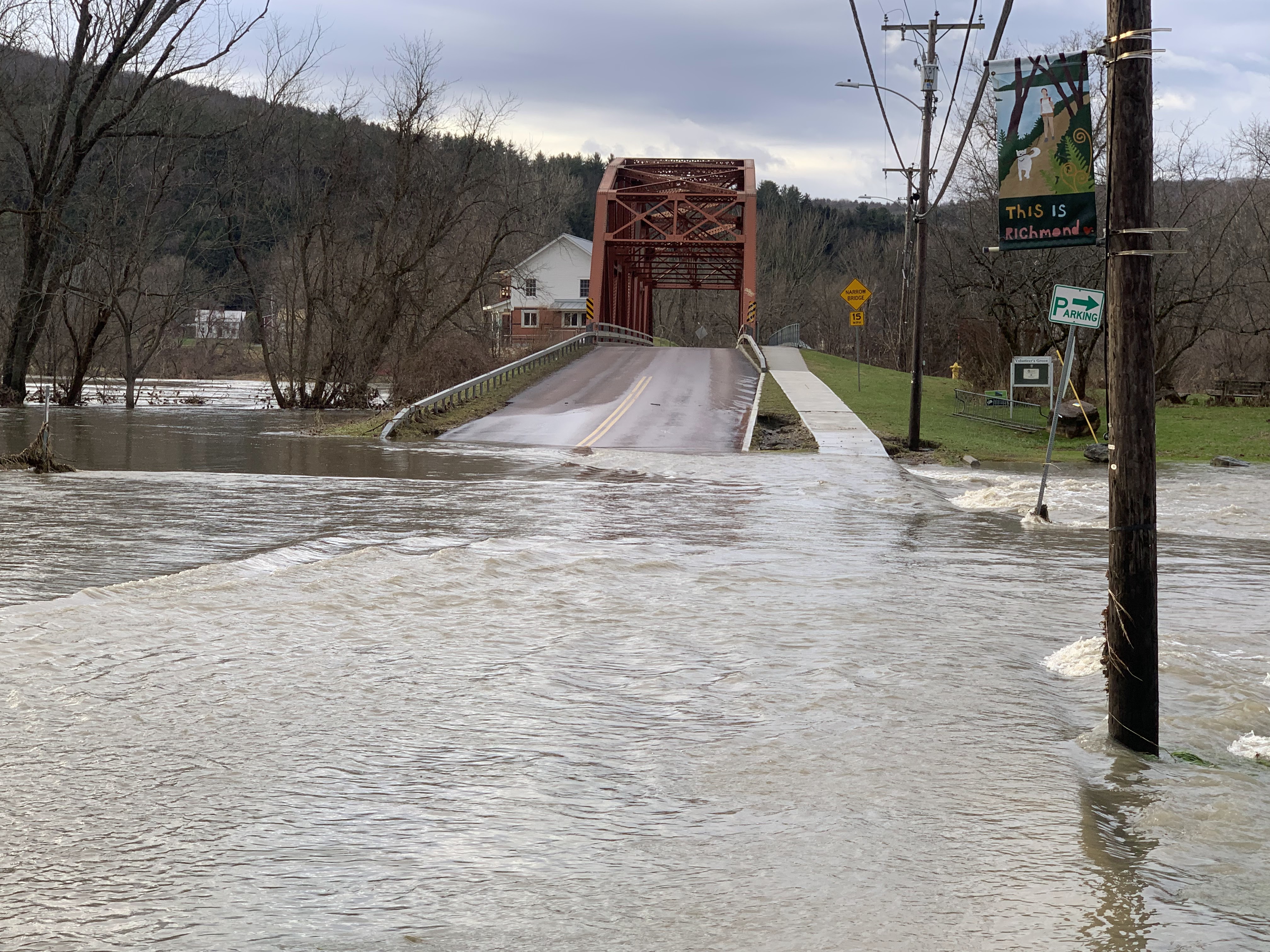
Flooding in Richmond, Vermont, December 19, 2023,
Heavy rain and warm temperatures in December made
groundwater sopping wet, but got rid of most of
Vermont's mountain snow cover. As things stand now
that leaves this spring's flood potential as "normal"
But a LOT can happen to change that one way
or another by March and April 
 Every year, starting in early January, the National Weather Service office in South Burlington, and other NWS offices, start to issue spring flood outlooks. 

Yeah, it's a little early to worry about spring floods, but I guess these early outlooks give us a baseline to start following trends.  

A lot can happen between now and spring to affect our chances of yet another unwelcome inundation around Vermont when it warms up in a few months. But it's OK to keep tabs.

For the record, the outlook issued last Thursday for spring flooding works out to normal, all things considered. As you are probably well aware, December in Vermont was sopping wet, so groundwater is definitely above average.

However, snow cover was far below average when the flood forecast was issued last week, so there's not a lot of moisture built up in the mountains to unleash as floodwater when temperatures rise in March and April.

That's one of the big wild cards, though. We know snow cover will increase this month from the paltry levels we saw last week.  Snow cover has already gone up in the past week, and might tonight. But it's still well below normal.   However, if the rest of the winter proves snowy, which is actually possible, that would change the outlook. 

Longer range forecasts indicate that starting about next Sunday, a new somewhat colder, and maybe (or maybe not!) somewhat drier weather pattern will take hold. I don't know if that will last all winter, or just be a brief blip, or something in between.  If it does hold for the rest of the winter, chances are snow cover will finally build up in the mountains. 

Which is one of the many reasons forecasting spring flooding is difficult to say the least in early January. 

Ice jams are a big hazard with spring floods in Vermont. River ice can get pretty thick during colder winters,  If a thaw breaks up that ice, those big chunks of ice can get stuck at barriers like bridges, creating a dam that results in a nasty upstream flood.

After the flooding and extraordinary warmth of December, there's almost no ice on Vermont rivers. So there's obviously no immediate threat of ice jams.

River ice will form as we get through January, but we don't know how thick it will get. Depends upon how cold it gets. The thicker the river ice, the greater the chances of ice jams that hold in place. Thinner ice breaks up into more small, slushy chunks that doesn't jam up so easily. 

In the immediate future, over the next week or so,  it's generally expected to be warmer and wetter than normal in Vermont.  As mentioned this morning, there is some threat of flooding with our storm tonight and tomorrow, but mostly in far southern Vermont. 

It's too soon to say whether the large storm expected Saturday will be warm and wet enough to create a flood threat. After that, as mentioned,  a cooler, somewhat drier trend is expected to take over. 

Another interesting wildcard is the Lake Champlain water level. It's much above normal for this time of year - only about half a foot below record highs for January. It has started to recede a bit from its late December peak though.  

The lake level will probably take another bump upward after the storm tonight and tomorrow, and another one expected on Saturday. After that, the lake will probably slowly recede during the rest of January and February,  unless it stays oddly warm and rainy.   ss it's especially warm and rainy. 

Still, if lake levels are still above normal in the spring, and there's a lot of snow that somehow accumulates in the mountains by then, we could have some real problems along the shores of Lake Champlain.  Especially if it's also a rainy spring. 

At this point, I'd say the risk is still low, but you never know. 


Friday, January 5, 2024

Great Lakes, And Lake Champlain Remarkably Ice-Free

St. Albans Bay on Lake Champlain was entirely ice free on
January 4. While large areas of the lake are often ice-free
this early in the winter, shallow, sheltered areas like
this bay are usually frozen by early January. 
After the second warmest December on record in Vermont, there's precious little ice on Lake Champlain. And many other lakes in the Green Mountain State for the matter.  

Shallow parts of Lake Champlain are often frozen by now. I live not far from St. Albans Bay, which is quite often frozen by January 1, but as of Thursday, it was wide open.   `

Of course, the weather patterns could change, and the lake could freeze up very nicely later this month and in February. 

But there is a risk that this year could become another year in which ice fishing - a big tradition on Lake Champlain - could become unsafe like last year 

Three people died last February when they fell through thin Lake Champlain ice during a remarkably warm winter.  The 43rd annual Islands Ice Fishing Derby in mid-February was called off due to the unsafe ice. 

This year, even smaller lakes in Vermont were ice-free as 2024 dawned. People on Lake Champlain are also fretting. WPTZ interviewed Valerie Hunter, owner of Keeler's Bay Variety Store in South Hero. She said:

"It's really sad because it cuts down on a lot of things, a lot of recreation things. A lot of people ice skate on the lake, they play hockey on the lake, they do a lot of other things on the lake that they're not able to do."

I can't predict what will happen later this winter, but climate change is making it more likely that we'll see thin or even no ice on Vermont lakes. Lake Champlain has only entirely frozen over once since 2016, and then only for a brief time in March, 2019. (It came close to freezing over in 2022).

It's not just Lake Champlain. 

The Great Lakes started 2024 with remarkably little ice, reports the Washington Post:

"The Great Lakes had the smallest amount of ice cover this New Year's Day in a least the past 50 years and are on track to see less than the seasonal average this winter, according to government data. The decline comes during a five-decade drop in ice cover that experts say is due in part to human-caused climate change."

Like in Lake Champlain, there's a lot of year-to-year variability in ice cover. And the amount of ice cover can increase in a flash if intense cold waves invade the Great Lakes region later this winter. 

Unusual for this time of year: A couple and their dog
walk along an entirely ice free St. Albans Bay with
no snow on the ground on January 4, 2024. 

Still, the amount of ice on the Great Lakes was remarkably paltry as 2024 began.  

It's true the Great Lakes don't start freezing in earnest until January, but this is ridiculous. On Monday, only 0.35 percent of the Great Lakes were under ice, says the Washington Post. Normally, about 9 percent of those lakes are ice covered on New Year's Day. 

Recent years have been pretty lame with Great Lakes ice on January 1. Last year, they were 4 percent ice covered. The year before that, it was 2.35 percent. 

Great Lakes ice cover is important for several reasons. Ice prevents storms from stirring up large waves that can batter the shoreline.  Open water means a greater likelihood of lake effect snowstorms on days when cold winds blow over the water and gain moisture from the lakes.

Lack of ice  can hurt tourism, as a lot of people like to go ice fishing. On the other hand, open Great Lakes water helps the shipping industry. 

Although some of the Great Lakes like Huron, Erie and Superior have entirely frozen over in some years, the entirety of the Great Lakes has never completed become ice covered. 

On average, the maximum ice coverage of the Great Lakes is 53 percent. The coverage since the early 1970s has ranged from a peak of 95 percent coverage in the frigid winter of 1979 to a low of 12 percent in 2002.

In the thirteen years since 2000, only five years saw Great Lakes ice coverage exceed the long term average. 

Thursday, December 21, 2023

Could Lingering Flood Echoes From Monday's Storm Spell Trouble Down The Road?

Severe, record breaking flooding along Lake Champlain
in May, 2011,  The lake is high now, but not quite flooding.
However, if heavy precipitation continues through the 
winter and spring, some shoreline flooding is possible
come next April and May 
 None of Vermont's rivers as far as I can tell are above flood stage anymore late this Thursday afternoon.

Yay! 

But the floods from early in the week are still causing lingering issues. Elsewhere in New England, and right here in Vermont. 

Down in Connecticut, the Connecticut River crested at moderate flood stage south of Hartford this morning. (It crested at Hartford yesterday afternoon at the highest level since Hurricane Irene in 2011).

The flooding had closed several roads and parks along the Connecticut River, but most homes and businesses are high enough to avoid damage.

In Maine, the Androscoggin River crested at major flood state Tuesday and Wednesday and was considered a 100 year flood. That means there's a one in 100 chance in a given year the flooding would get that bad. 

The flooding in Maine is likely the second worst in the state's history. 

Back here in Vermont, the only trouble spot remaining is Lake Champlain.  The lake level today had risen to 99.05 feet above sea level. It rose sharply as flooded rivers flowed in the lake Tuesday and Wednesday but seemed to be leveling off today. 

The lake level today is just under six inches below minor flood stage. It's also just a little under the record highs for this time of year, set in 1983.

With stiff north winds today, the lake was high enough to splash over onto roads near the shore, including the Route 2 Causeway connecting Colchester and South Hero.  That splash over froze onto the roadway, making conditions treacherous. There were probably other near-shore roads that suffered the same problem in today's chill.

Runoff from the flooding earlier this week made Lake
Champlain rise to just under six inches below minor
flood stage.  It appears to be leveling off now, 
There was also a minor version of something called a seiche on Lake Champlain today.  Steady north winds pretty much tilted the lake, making it a wee bit shallower on the north end and a little higher on the south end. On the far southern end of the lake, the minor flood stage of 99.5 feet might have been briefly reached today. 

The lake probably sloshed back northward as the sun set and the winds down down late this afternoon, and the lake level was very likely leveling off to something near horizontal.  

The current  high lake levels do raise questions as to what will happen when Lake Champlain reaches its typical yearly peak crest in the spring. 

The lake will surely begin to recede in the coming days, and typically slowly goes down or during January and February. Which means there's no immediate threat of any serious flooding.

Where trouble can arise is if the lake stays higher than normal through the winter. If deep snow eventually piles up in the mountains, and then we have a wet spring, the combination of snow melt and rain runoff could make Lake Champlain flood. Especially if it rises from a higher starting point in March or April than it usually does.

There's no real way to predict whether or not Lake Champlain will cause trouble in the spring. Ground water is certainly above normal as we head into the heart of winter, which could help encourage eventual flooding. However, mountain snow pack is far below normal at the moment. 

That said, nobody has any idea how much precipitation we'll get in the winter and spring. 

The National Weather Service in South Burlington usually starts a bi-weekly spring flood outlook in January and continues it into the early spring to give people an idea of whether there is much of a risk of another inundation. 

Yes, You Can Get Lake Effect Snows Off Lake Champlain

North winds created a band of lake effect snow off 
Lake Champlain this morning. Cold north winds picked up
moisture off the lake, and by the time those winds got
to a spot near Burlington, the snow began to fall a 
little over the lake.....
 The Great Lakes are famous for their lake effect snowstorms. Especially this time of year.

Cold air crosses the still relatively warm lakes. That warm lake water produces a lot of steam, which rises into clouds. The clouds head toward shore. 

The air once the cloud hit shore has to start rising to match the terrain. The rising air releases all that moisture in the clouds as snow. 

As we saw in Buffalo, New York last Christmas, these lake effect snow bands, when they're persistent, get quite scary. 

Smaller lakes can produce lake effect snows, too, if the wind is coming from the correct direction. Which is what was going on over Lake Champlain this morning.

The wind was coming out of the north, which is the same orientation as the long, skinny Lake Champlain. That kept the airflow over the lake long enough to produce those clouds, and eventually some lake effect snow.  A west wind wouldn't have worked. Lake Champlain is only 12 miles wide at its widest point. That's not a big enough fetch to create lake effect snows. A north wind is necessary.

You also need a pretty good sized contrast between the lake and air temperature. We had that this morning. The lake water temperature was 43 degrees and the air was close to 20 degrees. 

When the snow off Lake Champlain comes ashore, you rarely get those huge several foot deep storms. Lake Champlain lake effect is measured in just tenths of inches of snow, or sometimes a couple inches if you're lucky, 

The snow band kept getting a little stronger as you'd expect
as the clouds moved further south on the lake
and snow was falling over the lake and on the
shore. This is a view toward Shelburne. 

Radar images this morning showed lake effect snow falling from near Shelburne down into western Addison County.  

The people under the most intense - and that's being super generous - could see up to an inch of snow before the lake effect band breaks up by sometime this afternoon. 

There have been cases in which Lake Champlain lake effect snow has been impressive. 

On November 27, 1996, an oddly intense snow band of of Lake Champlain produced local snowfall rates of up to 1 or 2 inches per hour, with a total of 13 inches piling up in Cornwall, in Addison County. 

If you're going to see lake effect off Lake Champlain, it's most likely to happen in late November and December, and sometimes into January.  Later in the winter, much of the lake freezes over. The ice prevents that lake moisture from rising into the air to help produce our Champlain lake effect.

Monday, April 10, 2023

Satellite View Shows Diminishing Snow Cover In Vermont

Satellite photo from Sunday shows snow remaining
in the Green Mountains and Adirondack and in
much of northeastern Vermont.  Click on the map
to make it bigger and easier to view.
 Sunday was crystal clear and beautiful in Vermont, so it was time to take a sneak peek, via satellite photo, to trace Vermont's remaining snow cover. 

To nobody's surprise, there's been a big decline since April 1, when we last took a good look at satellite photos showing, among other things, the Green Mountain State's snow cover.  

Judging from the forecast, we'll lose a lot more snow in the coming days.

In Sunday's satellite photo taken in the morning before a little additional thawing got underway, areas along and east of the Green Mountains still have snow. You can see it as sort of that off-white hue.  

Unlike on April 1, if you look closely, you can see valleys in eastern Vermont are looking brown, meaning the snow is gone. You can really see it in the Connecticut River Valley south of St. Johnsbury, and to a somewhat lesser extent the White River Valley in east central Vermont, and the Winooski River valley in Washington County. 

The splotches that have the most brilliant white hue, compared to the rest, are mid and high elevations where snow cover is still pretty deep. As of Sunday morning, the high elevation town of Sutton in Caledonia County still had a foot of snow on the ground. Corinth, in Orange County, still had 14 inches. 

Mount Mansfield still had 73 inches of snow at the stake near the summit, just six inches less than it had on April 1.  I'm pretty sure you'll see decent declines in snow depth up there later in the week. 

That 73 inch snow depth up there is a little more than average for the date. Since mid-March, the Mount Mansfield snow depth has been somewhat above average, after spending the entire winter below normal. 

You can also see that north of the St. Lawrence River in Quebec, there is still a TON of snow on the ground.

On the very bright side, it seeming like we're escaping any substantial spring snow melt floods in Vermont. 

Locally heavy rains in northern Vermont on April 5, caused some minor flooding, but really, it was no big deal. 

This week, very little rain will accompany the melting snow.  Late in the week, high temperatures in higher elevations could reach well into the 50s and 60s, which would accelerate the runoff from the mountains. 

That'll probably mean river levels will remain on the high side, but nothing to really worry about.

As of Sunday, the Lake Champlain level was at 98.15 feet, a little less than two feet shy of flood stage. That level is also very close to normal for this time of year. 

The lake might continue to rise, but severe flooding on the lake is off the table, unless we somehow get record heavy rains in later in April and May, which seems pretty unlikely. 


Thursday, March 30, 2023

Satellite Photo Shows Vermont Snow Melt Progress

Visible satellite view of Vermont on Wednesday shows
many valley areas have lost their snow. Some interesting
areas in there, too. Click on the photo to make it 
bigger and easier to pick out details. 
 I came across an interesting visible satellite photo on the Burlington National Weather Service office web page yesterday, before the clouds rolled in. 

It gave a very clear view of how the snow has melted out of the Champlain Valley, and some of the lowlands in the Connecticut River Valley. 

The photo is in this post. Click on the image to make it bigger and easier to pick details out. 

One thing I noticed is the sharp line between no snow and snow in eastern Bennington, Rutland and Addison counties. 

The valley floors are virtually free of snow, but go up just a tiny bit in elevation along the western slopes of the Green Mountains, and you encounter solid snowpack. 

I noticed this as I drove through parts of Addison and Rutland counties on Sunday. Often during the spring thaw, the snow cover somewhat gradually goes from bare ground, to patchy to mostly snow to complete snow. On Sunday's trip,  I could see the abrupt change from no snow to complete snow cover,

This probably has a lot to do with the snowstorm on March 14-15. It was highly elevation dependent. The lowest elevations got modest amounts of snow, while elevations from about 900 feet and up got clobbered. That's probably part of what you see along those western slopes. 

If you also look closely, you can see the snow on the Taconic mountains in northwestern Bennington and western Rutland County. Again, you can discern the valleys. The little gap in the snow cover heading southeast to northwest in northern Bennington County and southwestern Rutland County is the Route 30 corridor in the Mettawee Valley.

By the way, that Mettawee Valley area of Route 30 is in my opinion the prettiest stretch of road in Vermont. Definitely worth a trip. 

Along another stretch of Route 30 in southeastern Vermont, you can see the snow free valley it travels heading northwest from Brattleboro, until the road encounters higher elevations and snow cover somewhere near Townshend or Jamaica. 

You can also see a gap in the snow cover in west-central Rutland County, with just a patch of snow to the north. That gap is the valley Route 4 takes toward Whitehall, New York. The small white patch to the north of Route 4 is Grandpa's Knob, and probably one or two higher peaks before the Taconics dwindle to nothing west of Brandon. 

A also think Grandpa's Knob is a wonderful name for a mountain. Or a senior citizen rock band. 

Looking much further north, if you squint your eyes,  you can sort of detect a narrow "crack" in the snow cover from far eastern Chittenden County through much of central Washington County. That's the Winooski River valley. The valley floor has little snow, but just slightly uphill from the river, you encounter a decent snow cover, 

Even further north, that patch of snow in central Franklin County just east of St. Albans is St. Albans Hill, just to the south of where I live.  My house is a third of the way up an adjacent, slightly smaller hill.  

I can attest that yesterday the bottom of the hill was snow free, my  yard still had patches of snow, and the top of the hill was almost totally snow covered. My hill is the tiny white dot north of the patch of white that is St. Albans Hill. 

You can also see that Lake Champlain is largely clear of ice, except the eastern part of the Lake from Malletts Bay in Colchester on up to St. Albans Bay.  The bays in the northern parts of the lake are usually the last to lose their ice in the spring. 

As we go through the next several weeks, on clear days, you'll see satellite images showing the snow cover retreating from both western and eastern Vermont, until only the summits of the Green Mountains. 

Friday, March 17, 2023

Just Like That, Two Big March Vermont Snowstorms Have Increased Spring Flood Threat

Snow-laden trees and deep snow this week around
St. Albans, Vermont.  A now much deeper snowpack
has somewhat increased the risk of spring flooding.
 Lo and behold, after pretty much an entire winter in which the snow pack in Vermont was well below average, the snow is now deep just as we're on the cusp of spring. 

That extra snow increases the flood threat in the coming weeks, but something like that is fortunately far from guaranteed.  It's still worth keeping an eye out on, though.  

The National Weather Service in South Burlington releases a winter and spring flood potential statement every other Thursday. Conveniently, the latest came just after the much larger of the two March snowstorms ended. 

Thursday's statement says the flood potential in northern and central Vermont is about normal. But it cautioned we'll have to start carefully watching weather patterns starting in about a week and a half. 

The amount of snow on the ground across Vermont - and the water in it - is now in many places above normal for this time of year.

The snow depth just below summit level on Mount Mansfield was  62 inches on Monday, just slightly below normal By Wednesday afternoon, the snow depth on the mountain had ballooned to 90 inches, which is roughly 15 inches above normal for the date.  

The snow water equivalent - the amount of "rain" available from the water in the snow and ice covering the ground is about 1.5 to 4 inches in the valleys, and four to eight inches at elevations between 1,500 and 2,500 feet.  I saw one measurement from Shrewsbury that showed 5.03 inches of "rain" locked up in the snowpack there. 

This week's snowstorm added one to three inches of snow water equivalent to the snowpack. Isolated areas in the high country of far southern Vermont added four inches of "rain" to the snow pack.

The snow cover in January and the first half of February was practically non-existent in Vermont. But much of the snow that has fallen since mid-February is still on the ground despite generally above average temperatures. That is in part because most of the above average temperatures have happened at night. Daytime readings have been closer to normal. So that limited much thawing so far. 

WHAT'S COMING

If you get the wrong kind of weather, that's a recipe for flooding.  The "wrong" weather is a sudden shift to much above normal temperatures combined with heavy rainfall.  

Jackson the Weather Dog is dwarfed by the big snow banks
he's inspecting for spring flood potential around
our house in St. Albans, Vermont. 

In the short term, that won't be a problem. Some light snow Thursday added a little tiny bit of potential flood water to the snow. 

Light rain causes some snow melt on Friday.  I noticed brooks and rivers rose somewhat with the thawing and rain, but nothing came close to flooding. And there's plenty of snow left to melt. 

A quick blast of chilly air will dump another dusting of snow in the valleys and a few inches in the central and northern Green Mountains. Again, just another small installment into the spring run-off potential from the mountains. 

Most of next week will have great sugaring weather, with highs near 40 and lows in the 20s. Great sugaring weather is also great flood prevention weather. A little snow melts each day, then things freeze up each night, so runoff isn't a problem.

Beyond that, it's beginning to look like we'll have a turn toward milder weather. The first shot at any spring flooding this year might be next weekend,  depending on the strength and path of the next storm system.  That storm is nearly a week away, so we don't know if it will be a warm, heavy rain, which would cause problem, or something more along the lines of what we had Friday, which wasn't at all scary.  

Even if the storm a week from now is warm and wet - again far from guaranteed - there will be plenty of snow left at mid-elevations and mountains to cause potential problems heading into April. Again, only if those spring rainstorms turn out to be hefty and drenching. 

Lake Champlain's lake level later this spring has gotten potentially more interesting, too. The lake level is around 96.4 feet, which is just slightly higher than normal for this time of year. 

Now, a lot of water has the potential to enter the lake from the surrounding countryside and mountains.  Especially if we have a lot of rain between now and May. 

Flood stage on the lake is 100 feet. I think we have a pretty good chance of achieving that. But minor flooding like that isn't a big problem. It's when we get up to 101 feet or so when trouble really begins. At this point, I don't think that will happen, but it is possible in a sort of low chance kind of way.

Whether we see any flooding this spring or not, I'm sure a lot of people will be relieved to see the snow banks around their homes gradually shrink and fade away under the warming rays of the sun.