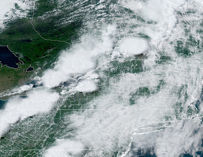
There had been a tornado watch out for all but eastern New York. It felt like tornado weather here in Vermont too, as winds became strong and gusty from the south, seemingly feeding into the line of storms and supercells over the St. Lawrence River Valley and near Montreal.
The storms caused flooding and wind damage around Montreal. Many trees and power lines came down in northwestern and far northern New York, too.
Radar showed one severe storm managed to make it all the way into far northwestern Vermont before dying out as it approached Jay Peak. That storm pounded Highgate with hail at least the size of quarter, and cars there are reportedly dented.
Just a little to the south and east was me, in St. Albans. The approaching storm looked menacing, a solid line of black to my west in New York State. By the time the storm was overhead, though, it was just a gentle thundershower. I saw a few cloud to cloud lightning strokes. Winds gusted to about 30 mph under the storm, which was actually calmer than the winds in the hours leading up to the storm. Rainfall was moderate.
By the time the storms reached Burlington, they could only muster 0.04 inches of rain.
Another couple of cold fronts are coming through today. They'll set off more showers and storms. Almost everybody will have at least a sprinkle. The showers were passing through northwestern Vermont this morning.
 |
| Storms looked ominous on approach to St. Albans, Vermont Thursday evening, but were rather gentle by the time they rolled into town. |
A few lucky devils might see some gusty winds and small hail, especially east of the Green Mountains. That's because there will be a few hours of heating before the showers get there. The sun's heat will help destabilize the air, giving a little extra energy to the showers and storms.
Then "winter" arrives.
COLD WAVE TO IMPRESS
After seasonable temperatures in the 70s to around 80, the second cold front comes through this evening, and that one will mean business.
Temperatures will crash this evening and overnight to the 40s to around 50 by dawn. That's not so bad, but then readings won't go up much tomorrow.
Saturday's weather is actually a classic winter upslope snow event. In those winter situations, cold northwest winds go up and over the Green Mountains dumping half a foot or a foot of snow on the mountains. The snow showers often back up into the Champlain Valley, so a couple to a few inches of snow pile up there, too.
But it's June. It's pretty hard to get snow near the Summer Solstice. That said, it's still looking cold enough for some wet snow flakes Saturday morning at the summits of the Adirondacks and northern Green Mountains. That's pretty unusual for late June.
The chill tomorrow is also impressive. Light rain now expected most of the day in the Champlain Valley will keep things particularly chilly. The record for lowest high temperature for Saturday is 56 degrees, and that might well be challenged.
Some colder spots in mid to high elevations and in the Northeast Kingdom might not get out of the 40s Saturday afternoon. Brisk north winds will make things feel even colder.
Though the coldest hollows might get into the 30s at night during this cold snap, it's good to know it won't get quite nippy enough to produce late season frost.
The strong upper level low causing this summer chill is looking like it will move out more slowly than earlier forecasts indicated. So Sunday is looking a little cloudier, and a little colder than first forecast. Western Vermont could see highs topping 60 degrees Sunday, while eastern Vermont, especially north of White River Junction stays in the 50s.
That's still very, very cold for June.
We're still looking at a slow warmup to seasonable weather once again by midweek, so summer ain't over, despite this weekend's very autumnal chill.


No comments:
Post a Comment