Meanwhile, this storm is also causing other types of very dangerous, and very weird weather elsewhere in the nation. We also have a brand new storm to talk about for later in this week.
I'll have more on that interesting stuff later this morning in a separate post. (I don't want to make this one too long and muddled).
Busy, busy times in the weather department!
THIS MORNING
As expected, the ice out there this morning is pretty patchy. As of dawn, we were starting a slow climb to above freezing temperatures, and some of us were there already.
Places like Burlington and Rutland and Springfield were barely above freezing as of 7 a.m. But surely, within just miles of those weather stations, the rain was still freezing in sub-32 degree temperatures.
If it's above freezing at your house when you read this, you're probably safe from more icing. But some unlucky places especially from the Green Mountains east could endure more freezing rain through the morning and possibly into the afternoon.
Also, as expected, power outages increased dramatically in the wee hours of the morning and continuing after dawn. As of 8:15 a.m. the trend line in power outages was still up, with more than 10,000 Vermont homes and businesses without power.
Almost all the outages so far have been very roughly within 25 miles either side of Route 4 all the way fro Fair Haven to White River Junction. That makes sense, as this general area was expected to see the thickest ice accumulation.
Scattered outages might well spread north east of the Green Mountains as rain continues to freeze to the trees and wires all the way to the Canadian border. I don't expect the outages to be super widespread as you head way north, as the ice accumulation won't get into the danger zone in most places. Just a few.
In the immediate Champlain Valley, the ice from overnight is pretty much over. I noticed a thin glaze of ice on the trees here at my house in St. Albans, Vermont. But as of 7:30 a.m. the temperature here was at 34 degrees, so we're getting no more ice accumulation. Melting snow was once again sliding off the roof.
Good riddance to the 5.9 inches of snow we received yesterday, frankly.
REST OF TODAY
 |
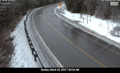
| Traffic camera image from Route 100 in Ludlow shows icy trees along the highway this morning. |
You'll be driving down a wet road with no noticeable ice on the trees, and suddenly, less than a mile down the road, the pavement is icy and the roadside trees are sagging under the weight of that ice.
Ice storm and winter storm warnings were in effect for most of Vermont early this morning. You'll probably see the National Weather Service in South Burlington remove these alerts piecemeal through the day as the ice danger slowly diminishes.
High temperatures today will actually come tonight. Readings will crawl upward through the 30s this afternoon, reaching the low 40s in the Champlain Valley and warmer western valleys by dark.
Temperatures will continue to slowly climb overnight tonight.
MONDAY
We're still looking at a big but brief surge of very mild air on Monday. Highs will reach well into the 50s with many of us getting pretty decently into the 60s.
The wintry, snowy, ice scenes of today in central and northern Vermont will quickly revert back to our early spring muddy, bare ground.
Continued showers, along with the rapidly melting snow and ice, should get the rivers and streams across Vermont rushing again. I can certainly see how this could cause some minor flooding, but all indications are we will thankfully escape anything serious.
At least some of our "usual suspect" Vermont rivers look like they'll reach flood stage on Monday. Current forecasts have the Mad River at Moretown cresting at half a foot above minor flood stage on Monday. The Otter Creek at Center Rutland should be getting pretty close to minor flood stage late Monday or early Tuesday.
It also looks like the Winooski River at Essex Junction will be very close to minor flood stage by Tuesday.
So be aware the next couple of days. Some roads right near Vermont's rivers might be closed or at least covered in water. But we certainly don't have to worry about yet another big flood disaster in Vermont with this storm. We've had enough, thank you.
A cold front will be approaching Monday afternoon, and there might well be some heavy showers along it, and perhaps a thunderstorm, too.
AFTER MONDAY
Monday night, it's back to winter as the cold front will bring us back down into the 20s by first thing Tuesday morning. There might be some icy patches on the roads Tuesday morning from the freeze. But at least the precipitation will be gone.
It'll only get into the 30s Tuesday afternoon, so pretty chilly for this time of year. Wednesday will be a little warmer, in anticipation of a storm toward Wednesday night and Thursday that might have some similarities to the one we're having now.
The big difference will be that if there is any snow or ice, it won't be nearly as much as we had this weekend. That new storm will probably also give us another very brief warmup and a decent shot of additional rain.
We'll have more details on that when we get closer to the event.


No comments:
Post a Comment