
 |
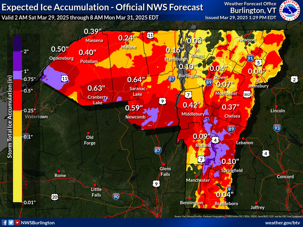
| Ice accumulation forecast map from the National Weather Service in South Burlington. This combines what's already' happened plus what's going. Areas in dark red, and especially lavender risk extensive tree and power line damage between now and Sunday. |
An ice storm warning is now up for most of central and southern Vermont through 8 p.m. Sunday. Expect very difficult travel - and much worse - likely pretty extensive tree and power line damage in some spots.
There's much more to talk about regarding the ice, but let's set the table with how today went.
Northern areas got the expected break. Once we got past 9 a.m. it was just light snow and flurries with no additional accumulation.
The big winner in the accumulation sweepstakes was Fletcher, with 10 inches. Johnson and South Hero had 8.8 inches. Burlington managed to tie today's daily record with 1954 for most snow on March 29 with 7.0 inches.
People near the Canadian border could actually see brighter skies just to the north late this afternoon. That does not mean the storm is over by any stretch of the imagination, but it's a break.
Road conditions across the north that were atrocious this morning and pretty good late this afternoon. They'll get worse again later, but we'll get to that.
OMINOUS ICE STORM
In parts of central and southern Vermont a few places already have a quarter to nearly a half inch of ice clinging to trees and power lines.
Power outages haven't been too bad - yet. All day, they've varied from near 100 homes and businesses without power to roughly 1,000.
I do think things will get much worse overnight.
As of 5:30 p.m. some renewed rain and areas of freezing rain were beginning to move back into far southern Vermont. That will spread northward overnight.
It's a complex temperature profile, so some places in the ice storm warning zone will only get a little freezing rain. Other spots will get a ton. And it will be incredibly variable. One area might be relatively OK, while a spot a couple miles up the road and a couple hundred feet higher or lower in elevation are absolutely slammed.
This is actually very typical of ice storms in mountainous places in Vermont. We saw this kind of thing in the Great Ice Storm of 1998. I remember in that storm driving up the hill on Interstate 89 between Richmond and Williston.
Halfway up the hill, it went from no ice on trees, to trees collapsing in a sharp line. Hardly no transition zone.
Our current ice storm won't be nearly as bad as 1998, but definitely bad enough.
ICE ACCUMULATION
 |
| Ice visible clinging to trees this afternoon in this traffic cam grab from Hartford, Vermont. Much more ice is possible tonight and that could cause some serious power outages and tree damage. |
And extending south a little into corners of Windham and Bennington counties and north into some pockets of Addison and Orange counties.
Between the ice on the trees now and what will hit tonight, everything in some spots by Sunday morning will probably be weighed down by a half inch to as much as an inch of ice in the worst hit areas.
I feel sorry for anybody who has a sugarbush or prized trees in the worst hit areas. If the forecast comes true, the damage will be extensive.
The power outages might be hard to fix, too, since there will probably be so much damage. Charge your devices now, those of you living in the ice storm warning zone.
The precipitation will hit northern Vermont again, too, later tonight and Sunday. It'll likely start off as snow and then go over the freezing rain. There won't be much additional snow, maybe an inch or so.
Places along and east of the Green Mountains in the northern half of the state will see up to a quarter inch of ice, which would cause some scattered power outages, but nothing like we expect further south.
The Champlain Valley will see a glaze of ice by early Sunday, too, but I don't think it will be enough to cause problems, other than dangerous road conditions.
As chilly temperatures slowly relax Sunday, any freezing rain will change to a cold rain. But in areas protected from any warming winds will hang on to more icing well into the afternoon. Luckily rainfall rates will decrease noticeably in the afternoon.
MONDAY
This still isn't the biggest deal of this storm, but we're still expecting a brief squirt of very warm, humid for the season air on Monday. Most of us will reach the 50s and 60s. Showers will continue, and as a cold front approaches in the afternoon, heavy showers and even a few thunderstorms look like they'll develop.
Flooding from melting snow and ice and the warm temperatures and the rain still looks like it will be minor, but we'll have to keep watching this. If rain ends up being heavier than expected, the flood situation could worsen.
I'm not too worried about that now, but it is worth monitoring.
No comments:
Post a Comment