Showing posts with label record temperatures. Show all posts

Thursday, August 22, 2024

Upper Level Cold Low Beginning To Depart, To Be Replaced By Weaker, Warmer One

Wednesday was as gloomy a Vermont summer day as you can get, as expected.

That pesky upper level low we've been talking about was right over us, ensuring the raw, wet weather continued all day.

You can see in the radar loop I've posted. 

Hard to see but focus on about St Albans in northwestern Vermont. You see all those numerous showers rotating around that point. 

Rainfall was pretty heavy in some spots, with waves of showers peaking during the early morning Wednesday, mid to late afternoon and again after midnight last night. 

It looks like Burlington got about two-thirds of an inch of rain out of this system, in addition to the three quarters of an inch that fell Monday.

Rainfall was really impressive here in St. Albans. My unofficial rain gauge collected 2.4 inches of rain.  The breakdown of that is the one inch of rain with the cold front Monday, then another 1.4 inches from Tuesday morning to this morning. 

Other spots reported very little rain. Montpelier had a half inch of rain with Monday's cold front, and about a tenth of an inch Tuesday and Wednesday,  It was hit and miss, as usual. 

There were a smattering of reports of ponding of water on some roads and minor flooding. A Facebook group showed a photo of water flowing across Leary Road in Jericho where it meets up with Nashville Road, for instance. 

All of Vermont rivers are far below flood stage and will cause absolutely no problems today. But they are still running pretty high for August. 

The thick clouds at night kept temperatures from crashing too much during this cool spell. Lows have been in the 50s, just a few degrees below average.

The clear skies southwest of this cold pool created record lows in the central Appalachians. There were even pockets of frost in the cold hollows of West Virginia Wednesday morning. Parkersburg, West Virginia reached 45 degrees, beat the record low for the date by six degrees.

Even though skies will be clearing over Vermont tonight, the atmosphere is warming, so it will only be kinda cool. Lows in the 48 to 55 degree range for most of us. 

Satellite view of the upper level low over northern
New England at around 6 p.m. Wednesday.  You
can also see a wisp of wildfire smoke wrapping 
around the outer edge of the system, extending
from Virginia and North Carolina to just off
the coast of Cape Cod, Massachusetts. 

The good news is this thing is now slowly on its way out. Today will be not great, but definitely better than yesterday. And Friday looks gorgeous.  

Some showers will still harass us today, but they won't be as numerous as they were on Wednesday, And we might even see some sun before the day ends. Especially in southern and western Vermont. 

It's back to summer tomorrow after our pre-autumn spell. It won't be THAT warm, but it'll be well into the 70s with quite a bit of sunshine. 

Going forward, the weekend and early next week look OK, but not perfectly sunny. We're still in a weird pattern that favors these cut off lows - pools of cool air in the upper atmosphere that are shunted away from the jet stream, so they don't move much.

It seems like another cut off low, one that will be far weaker and much warmer than the one that is currently departing, will make itself felt by Sunday night or Monday.

That just means we face another round of scattered showers during that period. Since this cut off low won't be bringing in a batch of cold Canadian air, temperatures will remain near normal for late Auset. That means highs in the 75 to 82 degree range and lows within a couple degrees of 60.


Wednesday, February 28, 2024

Record Warmth And Temperature Clash Caused Danger, Storms, Weirdness Across Much Of Nation

Screenshot of video taken through windshield as the
vehicle drove over a bridge with the Texas
wildfire beneath it. 
It's obviously not just Vermont going through strange weather, record highs, storminess and temperature swings. 

Other parts of the nation are getting either blasted or weirded out, too.   

TEXAS FIRES

Probably the most dangerous situation is in north Texas, where wildfires spun way out of control Tuesday amid rock bottom humidity and winds gusting to 70 mph.

 It didn't help that a cold front abruptly shifted the strong winds from the west to the north, making the fires especially erratic. 

One of the fires is the second largest in Texas history.  It's about half the size of Rhode Island and growing. That same fire also spread into Oklahoma and was 0 percent contained as of early this morning. 

The fires sent people fleeing from a series of rural towns and ranches north of Amarillo. 

Though details are still sketchy, the town of Fritch, population 2,000 appears to be hard hit, with an unknown number of homes lost, says the Associated Press. At one point, the city of Borger, population 13,000 was entirely surrounded by fire, so people couldn't flee. 

Several homes in the town of Canadian also burned, according to CNN.

Firefighting efforts and a wind shift kept most of the fire outside of Borger.

The wind has lightened up and cooler weather has arrived. There might even be a small amount of rain and snow Thursday. But dangerous fire conditions are forecast to return next week.  

MIDWEST TORNADOES

At least 13 tornadoes hit parts of northern Illinois, Ohio and Michigan yesterday and last night. That's very far north for tornadoes this time of year, especially that many. 

In late February, there is often an uptick in tornadoes, but those almost always occur in the Southeast during the last winter.  

Screenshot of tornado damage in Michigan this morning. 

In the Midwest, there were several reports of damage, but no serious injuries. Chicago's O'Hare airport was briefly under a tornado warning, but it appears no twisters touched down there. 

A few severe thunderstorms are possible today and this evening in a broad stripe along the Appalachians from Alabama to Vermont, but no additional tornadoes are forecast. 

TEMPERATURE WEIRDNESS

The cold front causing the severe weather and worsening the wildfires also caused lots of strange temperatures changes. 

Yankton, South Dakota was sunny and 70 degrees at 4 p.m. Monday. Exactly 24 hours later, it was 13 degrees and snowing. 

St. Louis reached 86 degrees on Tuesday, its hottest February day on record. Just 15 hours later, it was 60 degrees colder, at just 26 degrees. 

On Monday, Rockford, Illinois reached 73 degrees, breaking the record high for the entire month of February and for meteorological winter, which runs from December 1 through February 29.  That record lasted only one day, as Rockford reached  78 degrees Tuesday, incredible for that far north.

By 7 a.m. today, Rockford was down to 19 degrees with a north wind gusting to 51 mph and a wind chill of 2 above. 

It looks like at least 120 weather stations in the United States had their all time hottest February day over this past week. 

Record warmth hit parts of Canada, too. Ormstown, Quebec, about 50 miles northwest of Alburgh, Vermont,  reached 69 degrees, the hottest February temperature on record in the entire province of Quebec. 

Several cities in Ontario also had their hottest February day on record. The same cold front making temperatures crash in the United States is also hitting Canada. This morning, Sudbury, Ontario went from 41 degrees to 14 in an hour. 

SIERRA BLIZZARD 

A separate storm is set to cause one of the worst blizzards of the 21st century in the Sierra Nevada mountains. 

Between Thursday morning and Sunday morning, lower elevations near Lake Tahoe can expect two to four feet of snow with winds gusting to 60 mph. A little higher up, snow totals are expected to reach four to eight feet with winds gusting to 100 mph. 

Forecasters warn that travel will become virtually impossible for days, that stuck cars could end up being entirely buried in snow. Whiteout conditions will quickly disorient anyone out on foot. So it's a dangerous storm. 

One of the few bright sides to this storm is that total snow cover is lagging a little bit in the Sierra, and this will help them catch up. 

Saturday, December 10, 2022

Colder Regime Takes Over, Earlier Than First Thought

Frosted over leaves on a cold, but still snow-free
Saturday morning in St. Albans, Vermont.
Several days ago, I said the weather this December would be even more unpredictable than usual, and so far it's playing out that way. 

It looks like the guess work on how the rest of the month will go will remain extra tricky, too.

Long range forecasts issued in November suggested we'd have a cold December.  Those predictions flip flopped to warm as the month opened. 

But now that we're supposed to be in the midst of a warm spell, it has abruptly turned colder. Not super cold, but chilly enough.

Friday was the first day since November 29 that was cooler than average. Not by much, but it was on the chilly side. 

It was in the low to mid teens almost statewide this morning, and many of us won't make it out of the 20s this afternoon. It will sort of on the chilly side most of the upcoming week. But again, nothing that out of the ordinary. 

Even with the new chill arriving, the march into winter remains behind schedule. Friday was the first day this season that did not get above freezing all day. I checked back over the past 40 years and found only two years - 2015 and 1998 - that had a later first fully subfreezing day. 

In case you haven't noticed, there's not much in the way of snow out there, either. At least not yet. Meteorologists are still expecting a little light snow tomorrow afternoon and night, mostly south and west of Interstate 89. But nobodyi in Vermont  will receive more than an inch or two. 

Another storm might or might not come along at the end of the week. Some forecast models give us a snowstorm. Some give us a mix. Some give us nothing at all. Go figure.

All this unpredictability in the daily weather this month is ironically because of a rather well forecasted weather pattern.

It features a huge blocking high pressure system over and near Greenland that wants to help send cold air south into the eastern United States, and possibly provide an environment for snowfalls.

Meanwhile, a warm ridge of high pressure wants to make the eastern U.S. warm. Since I last wrote about this feature on December 4 the battle continues and the uncertainty remains. 

Record warmth has bathed the south  under that warm ridge that's causing the battle of seasons further north.

As the Washington Post's Capital Weather Gang reports, Mobile, Alabama (85 degrees), Macon, Georgia, (83 degrees)  and Savannah, Georgia (86 degrees) had their hottest temperatures for any December date on record.  

It's been in the 80s on six days this month in Houston already. The high temperature of 85 degrees on Tuesday. That would have been Houston's hottest December day on record, except for the fact it got up to 87 degrees just last December. 

Although we don't know whether this weather pattern will ultimately lead to storminess here in Vermont, it is leading to bad weather in swaths of the nation.

Much of the western United States is dealing this weekend with snow and wind. In the northern Plains, a winter storm watch is in effect for the first half of the upcoming week. 

Meanwhile, the Gulf Coast states are bracing for a possible tornado  and severe thunderstorm outbreak early next week


Monday, March 28, 2022

Another Cycle Of Fires, Wind, Tornadoes, Winter Weather Underway In U.S.

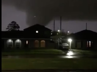
There might not be another destructive tornado in New
Orleans like last week, but the U.S. faces another week
of varied weather hazards through this week.
 After a lull lasting a few days, another big, lumbering storm is beginning its move across the nation, promising another round of just about everything imaginable.  

Up here in Vermont, the evolving pattern means kitchen sink weather this week. Meaning a little of everything, except the kitchen sink, but no guarantees on that. More on Vermont conditions in a bit.   

The kitchen sink weather isn't limited to Vermont. It's the whole nation, almost. 

Spring time is when we're most likely to see a wide variety of weather hazards and this spring is so far showing how true that is. 

WILDFIRES

The trouble started Sunday, well ahead of the storm. 

Wildfires are already breaking out once again in the warm air ahead of the system approaching from the Pacific Ocean.  This is continuing a trend of unusual wildfires this winter and early spring. 

A wildfire broke out near Boulder, Colorado over the weekend, right near the National Center for Atmospheric Research. 

Around 8,000 homes involving 19,000 people were evacuated because of this fire.  Thankfully no houses ended up seriously damaged. At least so far, as this wildfire is still burning. 

The area around Boulder is at the moment especially sensitive about wildfires after a blaze in late December burned about 1,000 homes. It was the worst wildfire in Colorado history. 

More fires broke out in Texas Sunday and those are forecast to increase today and tomorrow. It's been a rough year in places like Texas and Oklahoma as repeated wildfires have caused numerous evacuations, destroyed homes and ranches and killed at least one person.  

Still dormant vegetation, a long, intensifying drought, dry, strong winds and low humidity will ensure more fires today and tomorrow. 

TEMPERATURE WEIRDNESS

In some cases, the warm air in front of this evolving storm was downright hot. Las Vegas reached 93 degrees Saturday, the hottest day on record for the entire month of March. Death Valley, California also set the record high for the entire month of March with a reading of 104 degrees.

Record highs for the date including 79 in Salt Lake City, 87 in El Paso, Texas, 70 in Pocatello, Idaho and 84 in Pueblo, Colorado.

The buildup of warm air in the western and central North America has caused a corresponding dip in the jet stream over the Great Lakes and Northeast, as we well know.  It's frosty this morning in the Carolinas as a result, it's snowing around the Great Lakes and everybody has dug out their winter gear again. 

RAIN AND STORMS

The actual storminess made landfall in California Sunday night. Southern and central California are expecting the biggest storm since late December. Which unfortunately isn't saying much. 

After a very wet December, the rain and snow shut off in California in January and February, which is normally the peak of the wet season. Snow didn't build up in the mountains as it should, and low elevations dried out again. 

This storm will help,. but it's too little, too late.

The system will skip over to the east and redevelop in the central Plains tomorrow, then strengthen as it heads toward the Great Lakes by Thursday. 

This will set up a stripe of severe storms and possible tornadoes in Texas Oklahoma and Kansas tomorrow. The severe outbreak will peak Wednesday in the Gulf Coast states with more destructive storms and tornadoes.

The area in play for the greatest chances of tornadoes and severe storms Wednesday is almost identical to the area most affected by severe storms and tornadoes last Tuesday, including that destructive tornado in the New Orleans area

Thursday, the severe threat moves to the Middle Atlantic States as far north as New Jersey, which is unusually far north and east for this time of year.  

This whole storm system will probably also stir up a pretty decent winter storm in northern Minnesota and the northwestern Great Lakes. 

VERMONT IMPACTS

Hard to tell for sure, but web cam image of Interstate 89
bridge over Lamoille River in Milton looked icy.
Bridges and overpasses are especially troublesome today
The storm that will cause all this interesting national weather will, as I hinted at, give indirectly and directly give us a variety of weather the rest of the week. 

First, Snow, Cold

That dip in the jet stream I referenced above allowed the weather gods to grab a packet of Arctic air right from the North Pole and blast it down on us in Vermont today.

Um, yay?  

Temperatures were pretty uniform across Vermont early this morning, generally in the low to mid teens, with wind chills right around zero. It's actually a bit cooler than many of the already bone chilling forecasts had indicated.

There's still some disturbances rotating down from Canada in this air flow, so snow showers will continue off and on all day, especially in the central and northern Green Mountains. 

This is making some roads surprisingly slick this morning, or just giving motorists surprises. I was checking Vermont Agency of Transportation web cams this morning.  The ground temperature is relatively warm from the recent balmy weather. 

Narrow bands of heavier snow could develop here and there
today amid the cold snow flurries. Radar detected one such
band near Alburgh around 8 a.m. this morning and
this Vermont AOT web came along 
Route 78 in Alburgh seemed to confirm it. 
So in some spots, the light snow is partly melting.  Then re-freezing.  Or bridges and overpasses offer surprises As of 7 a.m. the traffic cam at the Lamoille River Bridge on Interstate 89 in Milton showed the pavement looking clear before and after the bridge, but the roadbed on the bridge itself looked really icy. Be careful! 

Since the snow showers will continue all day, and might actually increase a little this afternoon, the trip home could be a little interesting, too.

Not much snow will fall in the valleys, probably an inch or less additional, but a few more inches are likely in the already suddenly snowy central and northern Green Mountains. 

Highs today will only be 15 to 25 degrees, which for many of us will be near records for lowest "high" temperatures.  

Then what?

After a similarly frigid night tonight, a warm up will start. Sort of. Tomorrow will only get up to the low 30s, still way colder than normal for this time of year. 

It'll be a little better Wednesday afternoon as clouds increase, but it will still be a chilly 40 degrees.

From there we might have, yes, a little more snow or mixed precipitation Wednesday night with a warm front. 

Then, with the storm going by to our west, we'll have another temperature  swing upward - well into the 50s for most of us.  Don't get used to that, though.

Temperatures go right hack downhill next weekend.  It won't be nearly as bad as today is, but Thursday's foray into spring will be brief.  It'll only be in 30s and low 40s again for awhile after Thursday or possibly Friday.

They say April is a cruel month, and there you go, at least if that forecast is accurate.