
 |
| The general idea on accumulations with this huge nor'easter. The further east you go in New England the worse it will get. Click on the map to make it bigger and easier to see. Dark blue is four to six inches, rising to more than two feet near and southeast of Boston. |
Many of the little forecast changes I did see confirm what was already predicted.
As expected, the area covered by blizzard warnings has been expanded. In Massachusetts, where the blizzard warning this morning was just along the coast. Now, it extends inland to I-495 almost all the way west to Worcester, and all of Rhode Island.
Also included in the blizzard warning to southeastern Connecticut, the eastern two thirds of Long Island and parts of Delaware.
The blizzard warning was also extended inland in Maine, including Bangor.
In Vermont, the National Weather Service has settled on a winter weather advisory for the far southeast and northeast corners of state, with an expected accumulation of three to six inches in both places. Wind gusts of 40 mph will blow that snow around.
The rest of Vermont east of the Green Mountains could receive a badly windblown one to three inches of snow. Western Vermont, especially north of Rutland, can expect very little if anything. These figures could increase if the storm jogs further west, but so far, that's looking doubtful.
Interestingly, this snowfall scenario is what the American computer models were forecasting three days ago. Since them, all the models have flip flopped on how this will play out, but it's cool the American model had a good sense of things three days out with a very complicated system.
North winds gusting to 40 mph or so will make Saturday raw and miserable as actual temperatures stay in the single numbers.
Just as forecast, the storm started forming today off the northeast coast of Florida. It was amazing to see that the disorganized clump of light showers late this morning off of the coast between Florida and North Carolina will turn into this monster storm, but there you go.
This thing will develop explosively as it heads north tonight.
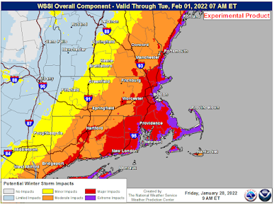 |
| Winter storm impact level is purple along the immediate New England coast, which is regarded as "extreme" Large area of red is "major" impacts |
I want to take a side excursion here and highlight something that really ticks me off. I've already brought up workplace safety issues in severe weather in previous posts.
I'm noticing, like in many dangerous blizzards that some employers are insisting workers show up in the midst of what will be a dangerous, life threatening storm in parts of New England.
Mostly these workers are in retail and fast food and that type of thing. Nobody in their right mind will shop or go out for a Big Mac in Boston or Providence or places like that tomorrow. Business will suck at these stores.
But, store owners and franchises can't lose the opportunity to make just a couple bucks. So what if the employees that they order to come in get hurt or even killed out on impassable roads right? They're regarded as replaceable cattle, so no great loss.
That attitude toward low wage workers in the U.S. is an abomination. But I guess I'm in the minority there.
OK, off the soapbox and back into the weather.
Needless to say, travel will be pretty much impossible in the areas under the blizzard warnings and in many areas under winter storm warnings. Snow in some places will accumulate at a rate of three or more inches per hour. The National Weather Service office in Boston says it's conceivable that snow accumulates in a few spots at a rate of five inches per hour, which is really off the charts.
That makes it impossible for road crews to keep up, especially since the strong winds will pile the snow into gigantic drifts.
Total accumulations of 1 to 3 feet will be common in eastern New England. I can easily see a few places getting three or more feet of snow with this.
Everyone in the blizzard area needs to stay at home during this. Totally safe there.
So far, at least 2,000 flights are canceled, including 85 percent of flights out of Boston's Logan Airport. By tomorrow, I'm guessing all Logan flights will be wiped out.
Back here in Vermont, we won't necessarily be out of the woods with winter storms, even as this giant nor'easter just barely glances us. Signs are beginning to point toward some sort of messy storm in the second half of next week for our area.
No comments:
Post a Comment