Showing posts with label Massachusetts. Show all posts

Tuesday, September 12, 2023

Vermont Getting Lucky With Storms, Rest Of New England, Not So Much

Severe flooding in Leominster, Mass.
Monday. Photo by Judy Jollimore.
If you live in Vermont, you might have been justified to complain a little about the gloomy, overcast conditions that lingered all day, or at least most of the day. 

You'll be pleased to know, though, we dodged another weather bullet. And more bullets flying in our general direction look destined to miss, too.

We've been dealing with a nearly stalled weather front over New England since last Thursday, which has caused round after round of storms in various parts of the region. 

The front settled just to the south and east of Vermont Monday, leaving us in the cool-ish damp murk.

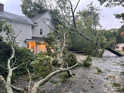
MASSACHUSETTS DISASTER

The southeastern half of New England was still on the warm,  humid side of the stalled front, and that's been causing flash flooding from torrential downpours since Saturday.

Yesterday, all hell broke loose in central Massachusetts, and to a slightly lesser extent in Rhode Island and Connecticut.

In Massachusetts, training thunderstorms, one after another going over the same spot, unleashed incredible downpours and flash floods, especially around Leominster, Fitchburg and surrounding communities. 

Leominster had 9.5 inches of rain in just a few hours. (The entire month of September there normally yields less than half that amount of rain).  Fitchburg, Massachusetts got a whopping 2.77 inches of rain in just one hour and a storm total of five inches. 

Numerous houses and businesses were flooded, at least one building collapsed in Leominster, and you basically couldn't get around town since all the roads were under water. This flood was on par with the inundation we got here in Vermont back in July, except yesterday's Massachusetts mess covered a smaller area. 

WEDNESDAY STORM

The next storm we have been talking about for days is still on track to hit New England tomorrow. NOAA's Storm Prediction Center continues to have most of the region, including Vermont, in a slight risk area for flash floods. 

I think the real danger zone might be southern New England again, which is most likely to get some torrential thunderstorms with this. 

A strong cold front will accompany this system. Here in Vermont, this thing should generally be well behaved, dumping less than an inch of rain on us through the day.  The isolated flash flood risk comes if any thunderstorms can get going just ahead of the cold front. The heavier downpours with those thunderstorms could cause a  high water problem here or there. It doesn't look like anything widespread will happen here. 

The cold front will give us a belated new introduction to autumn. In Burlington, Vermont it has been continuously above 60 degrees since the morning of September 2, which is a very strangely long time to stay that warm. 

This will end tomorrow night as both delightfully dry air with normal temperatures for mid-September finally arrive.

HURRICANE LEE

Though things could still change, it continues to look like Hurricane Lee won't be that big a deal here in Vermont. If the forecast track holds, it could end up being pretty breezy Saturday and/or Sunday, but beyond that, not much. Again, if the forecast track verifies, Vermont probably will get no rain, or at least very little rain from this hurricane.

For a few days now, the computer models, generally speaking have been making Hurricane Lee make landfall somewhere near western Nova Scotia. That the forecasts have been consistent on this gives me a little more confidence that this path will become reality. 

Again, though, hurricanes can always surprise. If the track of the storm goes much further west than expected, though, all bets are off. 

However, it looks like southern and especially eastern New England will take the brunt of this. As Hurricane Lee moves north, its top winds will weaken, but the area raked by strong winds will expand. That means coastal New England, especially Rhode Island on north to Maine, can expect high tides, large wages, beach erosion, and especially in eastern Maine, heavy rain.

The timing is still a bit of a question  mark, as some models bring Lee to near New England early Saturday, while some hold off until early Sunday. 

We still have to keep an eye on this, but if you have weekend plans for Provincetown, Nantucket or Bar Harbor,  you might want to reconsider.  

Saturday, August 19, 2023

Rare Rhode Island/Massachusetts Tornadoes Friday Morning

Screenshot from a Tesla video on I-295 in
Rhode Island shows the tornado crossing the highway. 
 While I was a post for this blog thingy early Friday morning and noticed quite a thunderstorm complex coming into Connecticut.  

At the time the forecast included a very low but not zero chance of tornadoes in New England, all the way into Vermont.  I wrote that I thought the Green Mountain State was pretty safe from a twister, but I wondered about far southern New England.

Well, I was right to wonder, as it turns out.  

A pretty concentrated area of tornadoes hit Rhode Island and southeastern Massachusetts a bit later Friday morning, causing quite a lot of damage, but no super serious injuries.

The most impressive tornado took an off and on path through Scituate, Johnston, and North Providence, Rhode Island. It was an EF-2 with top winds of 115 mph.  It was the strongest Rhode Island tornado since August of 1986,

Dramatically, the tornado crossed I-295 in Rhode Island, lifted a car several feet in the air, turned it around and then slammed it back down on the highway. The woman driving the car was taken to a hospital but her injuries were reported to be relatively minor. 

One house directly struck by the tornado lost most of its roof shingles, had windows blown in and the front door was dislodged from its frame. Hundreds of trees were uprooted or snapped off.

There were at least three other tornadoes in that general area, according to the National Weather Service office in the Boston area.

 An EF-1 with 80 to 90 mph winds caused damage in North Attleborough and Mansfield, Massachusetts. Another, higher end EF-1 with winds of up to 110 mph caused roof and tree damage in Weymouth, Massachusetts. A weaker, brief tornado, an EF-0 with winds of up to 90 mph, caused a little more damage in Stoughton, Massachusetts.

Meteorologists will be investigating other damage in Scotland, Connecticut to determine whether yet another tornado touched down there. 

So, four, possibly five tornadoes in southern New England. Like I said the other day, it's almost as if we have another tornado alley in that region.  

Here in Vermont, the weather Friday stayed well-behaved.  I saw no reports of any severe weather.  Although one or two instances of flash flooding had been considered possible, I have no reports of any high water or washouts. 

Today might not be the nicest Saturday ever, with clouds and plenty of light showers around, especially north. It'll be a cool one, too, as temperatures will barely make it to the low 70s in the warmer spots and many places will stay in the 60s. 

Autumn is coming!

Monday, February 14, 2022

Historic Cape Cod House Miraculously Survives Nor'easter, Will Live Another Day

This historic house teetering on the eroding dunes in Truro,
Massachusetts narrowly escaped falling into the Atlantic
Ocean during a late January nor'easter. It was moved
back from the brink shortly after the storm.  Photo
by David Ryan, Boston Globe. 
The day before a huge nor'easter struck New England on January 29, images of a house in Truro, Massachusetts made the rounds.  It was teetering over the edges of fast-eroding sand dunes. 

The house on outer Cape Cod would surely succumb to the waves the next day. 

It would have been a shame, really.  The house was built as long ago as 1850, (nobody is quite sure)  and nobody likes to see historic structures go.

Crews frantically reinforced the pilings under the house hours before the storm arrived and somehow, it worked! More of the sand dunes were swept away in the storm, and the only a small corner of the house was still on land.  But the pilings somehow held.

That would have been a brief victory. The next storm would have finished the house off. But more good fortune arrived. The house has been moved further back and is at a temporary spot firmly on sand dunes. They're looking for a permanent place for it. 

The Boston Globe reports the home is owned by the Dennis family, whoever they are, who could not b reached for comment.  The Dennises paid to move the house to its temporary spot off the stilts.  They'll need to obtain permits from the town of Truro to move it to a permanent location. 

I do hope that works out, as the historic house has gone through so much, so now we're left rooting for it. 

I mean, if walls could talk. The Boston Globe gives us a quick rundown of its history:

"Massachusetts Historical Commission records state that the building was constructed between 1880 and 1890, but Truro assessing records say it was built in 1850. It was originally built as a boathouse for the Pamet Life Saving Station, which had a full time staff that patrolled the beach for wrecks. The building housed rescue boats and eventually converted to a residential cottage after the station closed in the 1940s, according to Massachusetts Historical Commission records."

Cape Cod and the rest of coastal Massachusetts are dense with historic old buildings and houses. There's even an entire HGTV show called "Houses With History" which follows the exploits of three preservationists rescuing houses on parts of Cape Cod and the Massachusetts South Shore.

While many of the historic places in New England are very safe from any coastal erosion, some are not.  A combination of sinking land and rising sea levels due to climate change regularly endanger coastal landmarks. Two Massachusetts light houses had to be moved back from the shore back in 1996, and Nauset Light Bathhouse had to be moved in 2000.

The Boston Globe said many areas on the Cape lose three feet of land per year due to coastal erosion and a single bad storm can erase more than 60 feet of land.  This house in Truro is certainly not the last that will have to be moved inland from the shore on Cape Cod. Or worse, fall into the Atlantic Ocean. 

Cape Cod will continue to ever so slowly shrink as sea levels continue rising and the coastline erodes. Not only is this difficult for the people who have to move buildings, but for the entire communities affected.

Towns and cities in Massachusetts live or die by property tax revenue. Less property, less property taxes.  Plus, the beachfront homes are worth the most, so those create the most tax revenue. Get rid of those homes, and you leave a big hole in the budget. 

These are problems that will gradually keep getting worse as the years and decades go by.  The house in Truro this winter is just one symptom of that.  

Saturday, January 29, 2022

Blizzard Continues To Blast New England But Avoids Vermont- Early Afternoon Update

Blizzard conditions in Niantic,
Connecticut this morning. Photo
from Twitter
@New_EnglandWx1
As of early afternoon our New England blizzard is behaving as forecast, so kudos to all the meteorologists who have been keeping us up on this one. 

Gusts over hurricane force in some coastal locations, near zero visibility, bitter temperatures and such are all slamming eastern New England.

The storm has left a trail of broken power lines because of the wind. At last report, 100,000 people were without power in the Northeast. 

It is kind of a weird looking nor'easter, with one main center southeast of Cape Cod late this morning and a subsidiary storm trailing it off the Mid-Atlantic coast 

The storm might not look pretty from space but it sure is doing its job down here on the ground. 

 There was an unofficial report of a 98 mph atop a bluff in Truro.  So far, the highest official wind gust I've seen is 78 mph.  

As of 11 a.m., the most snow reported in New England was a foot in Attleborough, Massachusetts, but those totals will rise tremendously before all is said and done. 

One especially heavy band of snow has been parked along the Massachusetts South Shore for hours. That's where the highest snow totals will be reported - possibly near three feet.  It's also where meteorologists have said for a couple days said would be Ground Zero for heaviest snow.  That's an incredible forecasting feat to get that right a couple days in advance. 

In New Jersey, the snow was gradually diminishing as of noon, but there were plenty of reports of 15 or 16 inches of snow on the Jersey Shore. That area, along with parts of Long Island and Connecticut, officially had a blizzard, which is defined as at least three consecutive hours of 35 mph or greater winds combined with lots of falling and/or blowing snow. 

I'm sure Massachusetts will also soon go into the confirmed blizzard zone.

VERMONT UPDATE

There's certainly no blizzard in Vermont.

Satellite view of the big nor'easter. Click on the image
to make it bigger and easier to see. Note the bumpy
nature of the clouds near the coast, indicating heavy 
precipitation. Also note the clear skies just to the west
of Vermont in northern New York. The dry air is winning
out so far, preventing snow from getting much into Vermont.
The frigid, dry air from Quebec was winning out in Vermont as of noon. The light snow in southern and eastern Vermont was not advancing northwestward, at least so far, and where it was falling, it was light.

Up here in northwestern Vermont, the dry air victory is obvious. The overcast in St. Albans has thinned a bit. Clear blue skies are visible far off to the west. 

The cold air drainage from Quebec plus the overcast skies have kept temperatures from rising. Burlington reached 3 below at 5 a.m. and was still at that level at 9 a.m, and had only risen to 1 above at noon. .......

Winds, as expected, had increased, and probably will get even stronger as the afternoon goes on, so wind chills will continue to be miserable - in the teens and 20s below zero in most spots. 

Wednesday, October 27, 2021

Nor'easter Blasts Massachusetts Coast; Gusts To 94 MPH

The Duxbury, Massachusetts Fire Department posted
this photo of nor'easter damage in that town this morning.
Thank goodness the big nor'easter stayed off the coast.  

Had it come closer or moved just inland, virtually all of New England would have had an incredibly destructive blow.  

Since this one stayed offshore, most of the havoc is south and east of Interstate 95 in southern New England.

There's plenty of havoc, though! As many suspected,the storm really over-performed in terms of wind along and near the Massachusetts coast.  Edgartown, on Martha's Vineyard, gusted to 94 mph early this morning. Other wind reports include gusts to 87 mph in Scituate, 84 mph in Duxbury  and several gusts over 80 mph on Cape Cod.

The storm was rapidly strengthening when those high wind gusts hit. You tend to get the highest winds in a nor'easter when the storm is in its fast building stage. 

The National Weather Service was advising everyone along and east of Interstate 95 to stay indoors this morning because so many trees and wires were falling.  At last check, more than 400,000 people in Massachusetts had no electricity. 

Luckily, there was a fairly sharp cut off between destructive winds to the east and not so bad to the west. Gusts were mostly in the 40 to 45 mph range north and west of Interstate 95, so there weren't too many problems once you get inland. 

Even though astronomical tides were low, there was still storm surge flooding and immense, crashing waves hitting shore. 

Today's nor'easter hit just days before the 20th anniversary of the Perfect Storm, that famous storm depicted in the book and movie. Though this nor'easter isn't quite as bad as the Perfect Storm, it's still a powerhouse.

The winds will this nor'easter will slowly diminish through the day as the storm center lumbers gradually to the east and out to sea.  It might take on some tropical characteristics once it's way out there, but at that point won't be any threat to land.

Here in Vermont, the only effects we'll see from the nor'easter today are some gusty winds reaching at times to 30 mph.  That won't cause any problems other than ripping much of the remaining fall foliage from the trees. Some sunshine will develop today as well, giving us a break from two days of gloom.

The next storm comes along Friday night and Saturday. Unlike some forecasts that were made earlier in the week, this next storm doesn't look all that scary.  I guess no spooky weather moments for Halloween this year.

We'll get a decent slug of rain Friday night and Saturday, but it will be a typical storm. Maybe a half to three quarters of an inch of rain.  There had been some fears that the upcoming storm might carry the risk of damaging winds, but now we see that won't happen. 

Just plan your indoor stuff for Saturday and your outdoor stuff for Sunday, as the storm will have pretty much departed by then.