Showing posts with label Louisiana. Show all posts

Tuesday, January 27, 2026

Death Toll Rising From Winter Storm; Stubborn Deep Cold Raising The Stakes

The city of Oxford, Mississippi continues to post
photos of the ice storm destruction. Another example.

The death toll from the massive winter storm has risen to at least 34 in 14 states as the severe lingering effects of the snow and ice barrage continues to threaten more lives. 

As of mid-morning today, more than a half million homes and businesses remained without power, mainly in Louisiana, Mississippi and Tennessee. This, as temperatures reached record cold levels in the region this morning. 

In devastated northern Mississippi, temperatures are forecast to rise into the still-colder than average low 40s. At least that will melt some of the us. But a new, intense cold snap is set to hit by the end of the week, sending overnight temperatures back down into the single digits. 

Ice storm damage in Mississippi was even worse than in a historic 1994 storm. In 1994, it took 23 days for power to be fully restored. Officials said modernization could somewhat shorten the repair timeline this time, but probably not by all that much. 

In Tennessee, Nashville residents were told some parts of the city could remain without power for a week. Outlying areas will probably wait even longer. 

While the electricity is off in and around Nashville, the frigid weather continues, which is bad news for the thousands of people shivering without heat. High temperatures in Nashville should only reach the 20s and 30s through next Monday. This is a city where afternoon temperatures are normally around 50 degrees this time of year. 

Later on, the question of where to put the debris from millions of shattered trees in hundreds of communities in the South.  Right now, mountains of tree debris lines roads and streets. In some of the hardest hit cities, it looked like nearly every tree sustained at least a little damage. A lot of those trees are entirely destroyed. 

Roads in northern Mississippi are still coated in
thick layers of ice and snow even
though the storm ended late Sunday. 
They're not equipped to remove snow and
the thaws that usually follow winter storms
in the region have failed to arrive.
North of the ice zone, people are still clearing snow from a massive area from New Mexico to Maine and Canada. 

On Monday. 56 percent of the Lower 48 of the United States was covered in snow. At least a foot of snow fell in 18 states, including here in Vermont. Toronto, Canada endured its largest single day snowfall with about 22 inches of new snow. 

Travel problems continue to reverberate even after the storm has passed. 

American Airlines said this was their most disruptive storm in the company's 100-year history. American canceled 9,000 flights in the storm.  More cancelations and delays are possible over the next couple of days. 

Flight Aware showed about 2,300 flight canceled today, even after the storm has passed. Lingering ice and snow on the ground, and the disarray caused by the tens of thousands of cancellations during the actual storm, are helping to cause the problem.

In much of the South, highways are today still covered by thick layers of snow and ice. They don't have the equipment down there to remove all that ice. Usually, southerners wait for it to melt. Normally the melt doesn't' take long. This time, it is. 

The weird, extended Arctic weather is affecting most places east of the Rockies. 

Usually - at least in recent years and decades -  a severe winter cold wave lasts only a few days, and then it's largely over.   

This time, the frigid air is staying put. 

In Minneapolis, all but one of the past 11 days have gotten below zero. The next above zero daily low temperature is not expected until this coming Sunday.   

The cold weather pattern is forecast to last well into February. New York City's longest streak of consecutive below freezing days is 16, set in 1961. Given the forecasts, that record could be broken. 

Even Florida is enduring the chill. They've already had a couple hard freezes this winter and another is due tonight. Another, strong cold wave is forecast later this week. Temperatures could get down into the low and mid 20s around Orland and mid-30s as far south as Miami. 

Even worse, a nor'easter is expected to form off the East Coast. It's still unclear whether the storm will come close enough to shore to cause a blizzard. But even if the storm misses, it's almost certain to reinforce the cold air over the eastern United States.  


Wednesday, January 22, 2025

Gobsmacked By Incredible Gulf Coast Snow; Dangerous, All-Time Record Cold This Morning, Travel Paralyzed In Region.

Screen grab of web cam showing snowball fights and
dogs playing on snowy Bourbon Street, New Orleans.
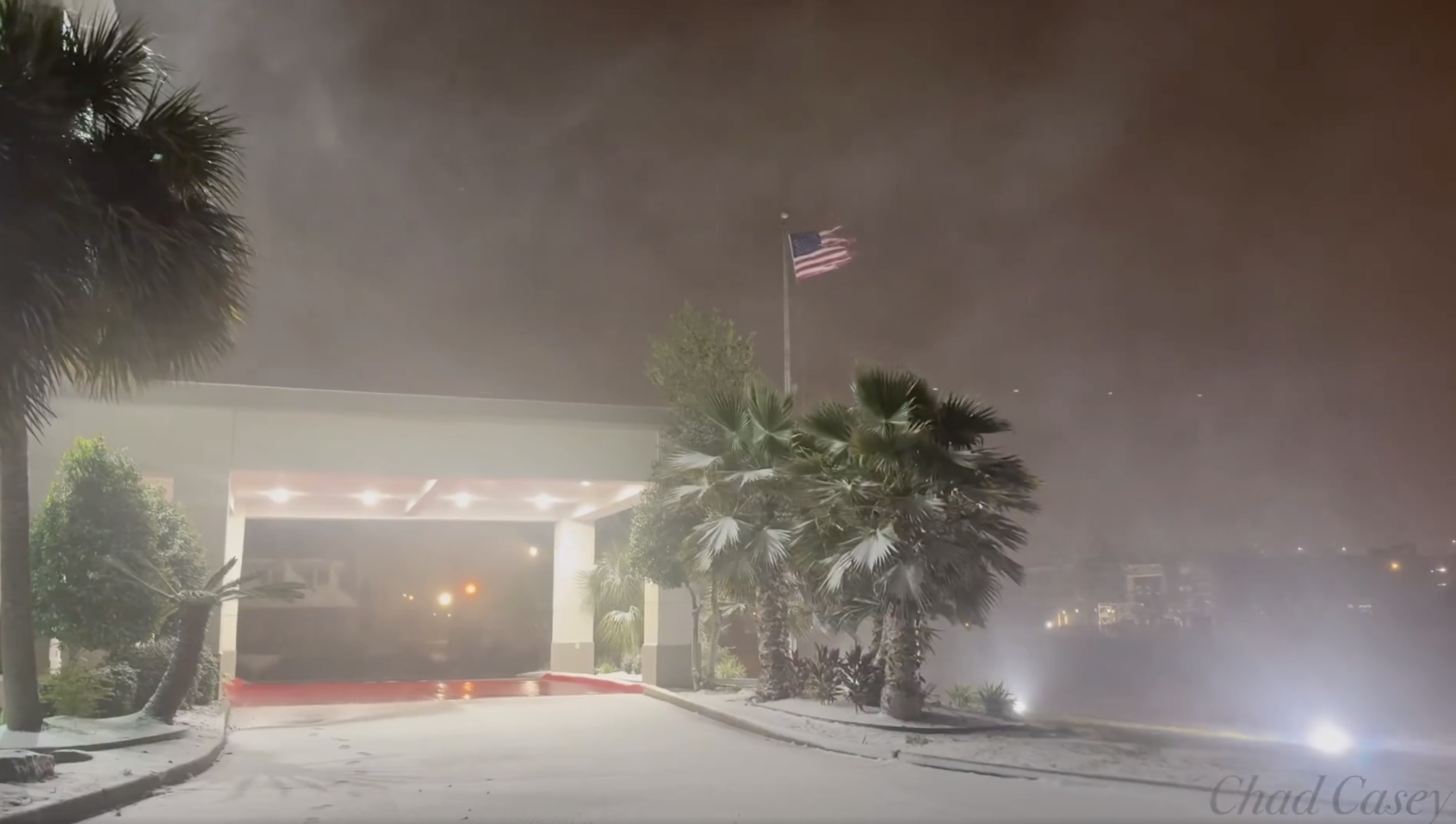
The incredible snowstorm that hit the Gulf Coast Tuesday is easily one of the most incredible weather events I've ever seen. 

Snowfall records were shattered as near blizzard conditions swept what are normally balmy, palm tree-lined beaches. 

New Orleans was buried beneath an official eight inches of snow, its largest snowstorm on record. Some sections of the city had more. Photos of a measurement in New Orleans' Garden District showed a solid foot of new snow. 

The Washington Post was as gobsmacked as I was when I saw these weather observations out of New Orleans.   

"A late morning observation from Louis Armstrong New Orleans International Airport reported a temperature of 27 degrees, heavy snow, 1/8 mile visibility - and three inches of snow on the ground. Two inches fell in one hour."

For at least seven consecutive hours heavy snow fell on New Orleans.

I saw one video showing a highway with zero visibility in snow and blowing snow.  I thought I was watching one of those lake effect blizzards in Buffalo. It was a highway in southwest Louisiana.  

Milton, Florida, not far from Pensacola, had 8.8 inches of snow, more than doubling the old record for largest snowstorm in Florida history. (The old record was four inches, also set in Milton). Pensacola, Florida and Baton Rouge, Louisiana each had 7.6 inches.  Mobile, Alabama clocked in with 7.5 inches. 

These shattered all-time records for snowfall in those cities. 

For comparison, the 24 hour snowfall in Milton, Florida of 8.8 inches is much more than double   the largest 24-hour snowfall in Milton, Vermont so far this winter, which was just 3.4 inches. 

Many northern parts of the United States have had less snow this winter than parts of the Gulf Coast, which is insane. 

Sioux Falls, South Dakota has had 6.2 inches of snow this entire winter so far, less than many Gulf Coast beach towns. Since December 1, Anchorage, Alaska has had 3.8 inches of snow (though to be fair, Anchorage did have some hefty snowfalls in late October)

DANGEROUS AFTERMATH

The Gulf Coast and Southeast snow zone is massive, running through most of the Texas coast, all the way through northern Florida and up into coastal Georgia and South and North Carolina. 

Somebody's Florida vacation photo
from Tuesday. 

The storm was departing and the last of the snow was departing the Southeast Coast, but the Gulf Coast is not out of trouble.

Tuesday was the fun day for most, as big and festive snowball fights broke out on Bourbon Street in New Orleans. Airboats that normally cruise through marshlands were pressed into service as snowmobiles. 

Families marveled at a snowstorm that they've never seen before and probably never will again unless they move north. 

But all that snow is now sitting there.  You can't drive anywhere. The Gulf Coast has elaborate and detailed emergency plans on what to do if a hurricane hits. Not so much with a snowstorm. 

It's obviously seriously cold on the Gulf Coast, and they're not equipped to handle it. What if there's a fire or medical emergency? How will ambulances and fire trucks get to the scene?

As of last night, a 150-mile stretch of Interstate 10 was closed. New Orleans borrowed 14 snow plows from an Indiana company.  Bucket loaders that normally shove sand off roads after hurricane storm surges were also pressed into service as snow plows in the region. 

The snow is not going to immediately melt much.  The forecast high temperature today in New Orleans today is 31 degrees. Clear skies, lighter winds and a snow covered ground brought the temperature in Mobile, Alabama down to a record-shattering 11 degrees this morning, with an expected "high" temperature today of 32 degrees. 

Even more extreme, Lake Charles, in southwestern Louisiana was down to just 6 degrees above zero this morning.  The previous record low for the date there was 18 degrees, so that's just incredible for them. 

Lafayette, Louisiana, where nine inches of snow fell yesterday, was at just 4 degrees above zero early this morning.  That is the coldest temperature on record for any date in Lafayette. New Iberia, Louisiana also set its all-time record low temperature at 3 degrees. So far, Beaumont, Texas has tied its all time low at 10 degrees. 

That's what a clear night sky with snow cover will do to you. That's never happened before in these cities, hence the extreme cold. 

Already, four deaths have been reported in the cold wave and snow, and I'm afraid that toll will rise. 

Temperatures are forecast to rise into the low to mid 40s across the Gulf Coast Thursday and Friday, which will melt some of the snow. But streets will still be in rough shape with overnight freezes.

Finally, temperatures this weekend will be back in the normal upper 50s and 60s, which should make the last of the snow disappear. 

WHY IT HAPPENED

You really need an exacting setup for this kind of weather event and it just so happened this time. 

Big Arctic cold blasts come all the way down to the Gulf Coast from time to time. But usually. that frigid air crosses the coastline and enters well into the Gulf of Mexico. Any storms that try to form on the leading edge of the cold air usually are too far south to bring any kind of precipitation to places like New Orleans.

Or, the cold air stops just short of the Gulf Coast, so it's warm enough for rain, not snow. 

This time, the leading edge of the frigid air stopped a short distance south of the Gulf Coast. As is often the case, a storm formed along the leading edge of the cold.  The storm pumped humid air northward over the frigid air near the surface in just perfect alignment with the coastline. 

The best moisture aloft and the best cold, moist air along the coast aligned perfectly to set up the snow. 

I won't blame climate change for this.  It was all probably a fluke. But some scientists say climate change does make the jet stream meander more, which can sometimes bring cold air oddly south, like in this case.  

Also, the Gulf of Mexico waters are still unusually warm, which can be blamed on climate change. The warmer waters probably boosted the amount of moisture available to the storm, which increased the amount of snow that could fall. 

Videos:

Blowing and drifting snow on the beaches of Louisiana and Texas, along with road havoc in the region. Click on this link to view, or if you see the image below click on that. 


The music doesn't stop in New Orleans just because it snows. Here's a trumpet player in the city's blizzard. Click on this link to view, or if you see the image below, click on that. 


Tuesday, January 21, 2025

An Absolutely Bonkers Winter Storm Is Striking Gulf Coast. Blizzard Warning In Coastal Louisiana!

Screen grab of video showing strong winds, snow and
blowing snow early today in Lake Charles, Louisiana,
which is, of all things under a blizzard warning.
 The National Weather Service home page weather map had things today I don't think I've ever seen before. 

Winter storm warnings are up from far southern Texas all the way across the entire Gulf Coast to the Big Bend area of Florida. Forecasts for the winter storm intensity have gone way up since I first reported on this storm on Sunday.

A blizzard warning, of all things, is in effect right along the Gulf Coast in extreme northeastern Texas and southwestern Louisiana, including the cities of Port Arthur and Lake Charles.

I'm certainly used to seeing tropical hurricanes come ashore in this area, but a blizzard?

The criteria for a blizzard warning in the Deep South is different than for places like, say, North Dakota, but this is still impressive. 

The Louisiana blizzard zone is getting bands of heavy snow and blowing snow with gusts of at least 35 mph, so that's an impressive winter storm. Total snowfall will run the four to eight inch range in that area today.

The area under the blizzard warning normally has a high temperature in the low to mid 60s this time of year with lows in 40s. It would be like Vermont having a full-blown blizzard in mid-May. 

We'll have plenty of for-examples of how bizarre this has gotten on the Gulf Coast today. I'm already seeing a few. 

Port Isabel, Texas, a near-tropical city along the southern Texas Gulf Coast right on the border with Mexico early this morning, had arguably worse winter weather than we're currently having in Vermont. At 5 a.m. it was 36 degrees, light snow with north winds of 36 gusting to 52 mph and a wind chill of 22 degrees. 

Normally, this time of year, Port Isabel has highs in the upper 60s and lows in the mid 50s. 

A wild National Weather Service home page this morning.
All that pink you see on the Gulf Coast is
all winter storm warnings 
Five or six inches of snow is forecast for New Orleans. That would make it easily the biggest snowstorm there since eight inches fell in February, 1895. The modern record for deepest snow in New Orleans is 2.7 inches in December, 1963. 

Pensacola, on Florida's Panhandle near the Alabama border, is anticipating two to four inches of snow today, with the possibility of five inches. The biggest snowstorm on record in Florida is four inches, so we might be rewriting history here.  

Winter storm warnings in Florida extend as far south as Gainesville, where freezing rain, sleet and snow could collapse trees and power lines. 

The winter storm is expected to continue today and tomorrow on up the coastlines of Georgia, South Carolina and North Carolina

DANGEROUS

This winter storm is obviously quite the novelty, but it's extremely dangerous. 

To be Captain Obvious here, the Gulf Coast isn't built for winter storms. They're much better at handling full-fledged hurricanes than this type of weather. 

The six inches or more of snow that could fall in Louisiana could collapse roofs, since they're not built for snow loads like they are here in New England. 

The Deep South isn't used to such cold weather, either.  Pipes aren't insulated, so they'll freeze.  The epic freeze in Texas in February, 2021 caused billions of dollars in damage as frozen pipes burst, flooding homes, condos and commercial buildings. 

Snow on the ground makes frigid nights even colder. A snow-covered Deep South could end up with record temperatures in the single numbers and teens tonight or tomorrow night. 

Travel is - or will soon be - impossible in the Gulf Coast winter storm zone. It's not exactly like they have armies of snow plows and sanders to clear the roads. People there also understandably have no clue how to drive in the snow.

As of the pre-dawn hours, Houston freeways were already an icy disaster and parts of Interstate 10 in Louisiana were already closed. 

Airports are shutting down in the region, too.

The governors of Florida, Georgia, Louisiana, Mississippi and Alabama have all declared states of emergency because of this weird storm.  

The silver lining to this storm is the weather along the Gulf of Mexico should return to normal by the end of the week. Which is good, because they'll have to wait for the snow and ice to melt before anything can be done about the situation. 

Daytime temperatures should rise into the 40s by Wednesday. By Sunday, New Orleans expects a high temperature of 65, Houston should get to 68, and Pensacola is anticipating a Sunday high of 62.

Saturday, December 28, 2024

Dangerous Tornado Outbreak Lurks In Southern United States Today

There's a risk of tornadoes, some strong and long lasting
in the South today and tonight. The greatest risk is in
the orange and red zones of this map. 
 A year-end tornado outbreak seems like it's about to blossom in the South today, throwing one more potential disaster as a United States to close a year that brought us far too many destructive storms.  

NOAA's Storm Prediction Center says most of the Gulf Coast states from eastern Texas to Georgia, and as far north as Tennessee are under the gun today.  The most threatened area is in central Louisiana and southern Mississippi, 

The bad weather was getting off to an ominously early start. At least five tornado reports came in from right along the Gulf Coast in Alabama and Mississippi yesterday.

Already as of mid-morning, a tornado watch has been issued for most of Louisiana, along with far eastern Texas and southwestern Mississippi.  A smattering of tornado warnings have already been issued in Louisiana, and severe thunderstorm watch is added to the mix in northeast Texas and southwest Arkansas.

It's only going to get worse as the day goes on, apparently. 

There is enough spin in the atmosphere to create the risk of a few isolated twisters this morning where there's that tornado watch. That there's already a small risk before the main show arrives feels ominous to me, like all hell might break loose this afternoon.

We have no guarantee that will happen of course. But forecasters do say that this afternoon, that same area will see dramatically worse atmospheric condition.  

THE SETUP

A strengthening storm will pass north and west of the main tornado risk area later today and tonight, dragging a cold front towards the region.  The cold front should contain lines of severe thunderstorms with some exceptionally strong winds and some embedded tornadoes.

Worse, in the warm, humid air ahead of the cold front, powerful, rotating supercell thunderstorms are expected.  The changing wind speeds and direction with height near these storms could help them produce strong, cycling tornadoes. 

That means a long lasting supercell would put down a strong tornado that would blast through a region for several miles. Then it would lift, only to drop another intense tornado and so on and so forth. 

That's the kind of storm that produced a series of tornadoes in and near Kentucky in December, 2021 including one that virtually destroyed the small city of Mayfield. 

If this type of storm happens with this episode, a lot of it would happen at night, just as it did in December, 2021

These tornadic storms are especially dangerous at night, since people are not awake to receive warnings. Also, despite warnings on TV and weather radios, human nature, being what it is, makes people want to rely on visual cues that a tornado is coming. 

You don't have those visual cues at night. So people might not take shelter until it's too late.

For now, there's a moderate risk of tornadoes in parts of the South, which is the second highest of a five point alert level.  The Storm Prediction Center considered raising the alert level to the highest level, which is rare for winter, but there's still a little uncertainty about how the storms will take shape. 

Of course, as of this morning, we don't yet know how many tornadoes we'll see, or how strong that might be. We also don't know whether they'll blast through populated areas, or remain relatively harmlessly over open fields or in dense southern forests. 

Tomorrow the tornado and severe weather threat will move into the Southeastern U.S, with areas from Georgia to southern Virginia at risk.

WINTER TORNADOES

Spring and early summer are the peak times for tornadoes, but winter outbreaks do happen sometime.

If those winter tornado swarms do happen, it's most likely in the Gulf Coast states. That's because that area is in close proximity to the muggy air over the Gulf of Mexico, which can be drawn inland by some storms. That oppressive air is a key ingredient for tornadoes. 

One of the most notorious winter tornado outbreaks of the past is that December, 2021 episode I've already mentioned.  The tornado that hit Mayfield was the nation's deadliest December tornado on record its 165-mile path was among the longest for any tornado on record. 

Another tornado outbreak on January 21-22 1999 unleashed 129 tornadoes from Missouri to Texas, causing nine deaths and 39 injuries. 

While there has been no big overall change in the number of U.S. tornadoes over the decades, they are increasing somewhat in the winter.   

Cold weather this tine of year usually squashes the possibility of tornadoes. But some scientists think that because winter warm spells are getting toastier, that opens the door to more tornadoes than we once had during the cold seaoosn


Sunday, November 10, 2024

It's Winter Somewhere! Surprisingly Strong Snowstorm/Blizzard Strikes New Mexico/Colorado

Aftermath of the big snow over the past
few days in North Colorado Springs,
Colorado. Photo by Matthew Soifer
via Facebook.
 The nation's first big disruptive snowstorm of the winter season is hitting New Mexico and Colorado, and we are starting the winter with a doozy. 

Widespread travel disruptions hit areas Thursday  from Albuquerque to Denver and beyond.  Snow totals were impressive to say the least.

Fort Garland, Colorado reported 53 inches Trinidad, Colorado came in with 44 inches. Beulah, Colorado and Angel Fire, New Mexico had 40 inches. 

The interesting thing is some of the biggest snow totals were out in the High Plains east and south of Colorado Springs and Denver, and not necessarily so much in the mountains. 

Colorado Springs had at least 20 inches.

Denver's 20 inches of snow was their 11th biggest snowstorm on record and third biggest in November. 

Luckily, the snow totals in the cities situated in some of relatively lower elevations sound worse than they are. The snowfall was spread over several days  

The still-warm ground melted some of the snow from below. The snow in Denver fell over the course of five days and the snow depth peaked at 13 inches. The multi-day duration was mostly because this was really two storms in one. 

The snow depth in Colorado Springs never really got deeper than eight inches. 

However the snow did manage to pile up on elevated surfaces like roofs, and trees and sheds, causing some damage. 

The drawback to having the snow fall over several days is that flight delays and cancellations really ramped up at Denver Airport. It has since stopped snowing, so the airports in the region are clearing the backlog of flights. 

  New Mexico's governor declared a state of emergency Thursday for much of the northern part of the state as the early season wet snowstorm cut power from Albuquerque to Santa Fe, cutting power to thousands of people.

The leaves were still on the trees in many areas, which made the situation much worse. The snow clung to the leaves, pulling down trees and branches that might otherwise have withstood the snow had the trees been winter bare. 

At least 100 vehicles were reported stranded on highways in northeastern New Mexico, where a blizzard warning was in effect until 5 p.m. Friday.  

The snowstorm followed what had been up to now an unusually warm autumn in Colorado, which means that, like in New Mexico, some of the leaves are still on the trees. Especially in urban and suburban areas of Denver and other areas outside the mountains.

That contributed to a bunch of power outages that are now being repaired. Electricity appeared to be almost completely restored in Colorado  and in New Mexico as of Sunday morning.  

The storm has departed Colorado. The forecast for cities like Denver and Colorado is for sunshine the entire week with highs in the 50s to near 60, so the snow should melt pretty fast. 

As a parting shot, the storm's cold front eventually grabbed some moisture from dying former Hurricane Rafael in the Gulf of Mexico. That ended up dumping torrential rains and creating lots of flash flooding in Louisiana this weekend. 

The storm system that caused the Colorado snow and contributed to the Louisiana flood is the same one that is coming through the Northeast with some needed rain on Monday. 

However, the storm is now much, much weaker than it was and still getting weaker. So the Northeast won't get all that much rain out of this system.

Sunday, September 15, 2024

Followup: Hurricane Damaged Louisiana High Rise Imploded, Is Gone

 Back in June, we told you about the 22-story Capital One Tower in Lake Charles, Louisiana, that sat vacant and boarded up since Category 4 Hurricane Laura trashed it back in August, 2020.  

The old Capital One skyscraper in Lake Charles, Louisiana 
comes down on September 7 after sitting vacant for
years. It was badly damaged when 
Hurricana Laura struck in 2020.

Much or even most of its green reflective glass windows were blown out. Offices inside the tower - the tallest in Lake Charles - were severely damaged or destroyed. 

The building sat boarded up, sad, ugly and untouched since then, as insurers, property owners and developers wrangled over its fate. 

Finally, with the help of the mayor of St. Charles putting his foot down, it was decided to just get rid of it. The mayor said the damn thing had kind of outlived its usefulness even before the hurricane. 

On September 7, demolition crews imploded the building as people in the city gathered to watch. It came down in a matter of seconds. This might well be the largest building-  or at least the tallest - in the United States that had to be demolished due to damage from a weather disaster

The area where the building was will be redeveloped. 

Videos

News crew guides us through the demolition. Click on this link or if you see the image below, click on that:

Another video: Again, click on this link, or if you see the image below, click on that. 


Thursday, September 12, 2024

Francine, No Longer A Hurricane, Still Spinning Off Flooding, Twisters

True to form The Weather Channel's Jim Cantore
reports from near the eye of Hurricane Francine
on Wednesday in this screen grab 
from the Weather Channel. 
 Then Hurricane Francine did what forecaster said it would do last evening, pummeling hurricane-prone Louisiana with another blow.   

Though this one won't go down in history as among the worst, its 100 mph winds, storm surges and blinding rain, smashing through an area not fully recovered from even stronger hurricanes in 2020 and 2021.

So far, fingers crossed, I haven't heard of any deaths from this storm in Louisiana. But damage reports are just emerging. At least 390,000 homes and businesses were without power in Louisiana, reported the Associated Press, with another 46,000 in Mississippi.

Video emerging on social media show mobile homes blown apart, trees snapped, roods damaged, power lines down and a lot of flooding. 

New Orleans streets were flooded after the city was battered by 7.33 inches of rain and wind gusts as high as 78 mph. 

Francine has moved well inland, and as of 7 a.m. today was a tropical depression over central Mississippi with top winds of just 35 mph. 

As you can tell, winds are no longer a factor with Francine. But its remnants are spreading heavy rain and a real flood risk over parts of the Southeast. The byproducts of Francine might also spin up a few tornadoes today in the Florida Panhandle and Alabama. 

The remnants of Francine are trapped over the Southeast by strong high pressure over New England snd southeast Canada. That will prevent us here in Vermont from seeing any effects from the former hurricane. 

Another disturbance way out there in the eastern Atlantic Ocean is likely to become Tropical Storm Gordon later today. It's far away and expected to develop only slowly.  It's days away from any threats to land, and we are not quite sure where wannabe Gordon will go as it develops. 

A storm might also form in the coming days off the Southeast coast and possibly become a subtropical or tropical storm next week. If it forms, it could head into the Carolinas. Also, again, if this system does become something, the same high pressure that is keeping Francine at bay would also keep this thing well south of Vermont, so it wouldn't bother us. 

Wednesday, September 11, 2024

Hurricane Francine To Smack Louisiana This Evening With Intense Winds, Storm Surge, Flooding

Satellite view of Hurricane Francine late this morning.
UPDATE: 5:30 p.m. EDT

Hurricane Francine managed to strengthen a little bit late this afternoon shortly before making landfall in Louisiana. 

Top sustained winds were 100 mph as of the 5 p.m. advisory from the National Hurricane Center.

This despite increasing upper level winds which tend to weaken hurricanes.

The storm should come ashore this evening, with those 100 mph. Francine has pretty much run out of time to either strengthen or weaken. 

As of late this afternoon, winds were increasing and storm surges were moving in along the Louisiana coast. 

Expect a rough evening in Louisiana.

PREVIOUS DISCUSSION

The forecast for Hurricane Francine has so far turned out to be accurate as the storm bears down on Louisiana today. 

At last check, top sustained winds were at 90 mph.  Francine has a brief opportunity to strengthen before stronger upper level winds prevent further gains in power right before landfall. 

Still, this storm will be a big problem for much of Louisiana. Storm surges will rise to as much as ten feet right where the storm comes ashore and just east of that spot. Landfall looks like it will be somewhere near Morgan City, Louisiana late this afternoon or evening. 

Luckily, Francine is no Katrina, so main levees in the most flood prone areas like New Orleans should hold.

However, smaller levees in somewhat less populated areas, or smaller levees elsewhere might get overwhelmed, so there certainly will be some coastal flooding. 

Winds at landfall should still be around 90 mph, but those will diminish quickly once the storm moves inland. However, the risk of flooding won't disappear once Francine is inland. 

The upper level winds that are forecast to hit Francine just before landfall might change the shape of the storm from something circular to more of a comma shape. Areas within that expected "comma" with a feeder band coming in from the Gulf of Mexico, will be most at risk for flash flooding and tornadoes. 

Both New Orleans and Baton Rouge could see rainfall rates of up to four inches per hour in the worst of it.  People in both cities spent Tuesday filling sandbags to at least try and ward off the expected floodwaters. 

Once inland, Francine or its remains will sputter out in the lower to mid Mississippi Valley, spreading the risk of some flash flooding in that region later today and tomorrow. 

As I mentioned in an earlier post today, Francine won't have any effect on us up here in Vermont. 

Monday, September 9, 2024

Tropical Storm Francine Forms; Will Be A Hurricane

Tropical Storm Francine was beginning to have
"that look" that suggests a potential formidable
hurricane as it organized early Monday afternoon
off the northeastern coast of Mexico.
 That Gulf of Mexico system I mentioned in this morning's post did what I said it would do: It became Tropical Storm Francine.    

It was organizing pretty fast off the coast of northeastern Mexico as of early afternoon. It will head north to northeast while gaining muscle.  It might actually strengthen pretty fast, given the near record hot waters of the Gulf of Mexico that are feeding the system. 

There's not much in the way of strong winds high in the sky over the top of Francine, either, which will help it blossom further. Stronger upper level winds, called shear, tends to interfere with hurricanes.  Since there's not much shear, Francine is free to gain more power. 

The pace at which Francine was strengthening and organizing early this afternoon seems a little faster than earlier forecasts, which feels a little ominous. 

Francine should end up along the coast of southwestern Louisiana, probably around Wednesday evening. Determining how strong a hurricane will be at landfall a couple days in advance is always a chancy proposition. 

Current thinking has it maybe with top wind speeds of 90 mph.  One potential saving grace is that stronger winds aloft are forecast to develop at the time Francine is approaching the coast. That, hopefully, would squelch its efforts to intensify.  

Still, people in Louisiana had better stay on their toes with this one, as damaging winds, dangerous storm surges and inland flooding are all very much on the table.

Once Francine goes inland, its strong winds will diminish quickly, but it will remain a flood threat with heavy rains in the lower Mississippi Valley. 

At this point, the strong high pressure I highlighted this morning over the Northeast should deflect the remnants of Francine away from Vermont. Not a guarantee on that, but that's really the way it looks now.

Francine ends a long pause in tropical storm and hurricane activity that had been unexpected. Atlantic hurricane season this year has been widely expected to be a doozy. 

It certainly got off to rousing start with three hurricanes by mid-August. Beryl was the earliest Category 5 on record. Debby caused damage in Florida and on up the East Coast. The remnants of both Beryl and Debby caused flood and/or wind damage here in Vermont.

Ernesto hit Bermuda in August.  It eventually died on August 20 over the cold waters of the North Atlantic, and there had strangely been no tropical storms or hurricanes in the Atlantic until Francine formed this morning. 

The National Hurricane Center is also watching two other disturbances that have a pretty high chance of turning into tropical storms. One of them is in the central tropical Atlantic Ocean, and another one seems like it might get going in a few days off the western African coast.

It's still way too early to figure out what those two systems might end up doing or where they'll go. Despite the long, welcome lull in tropical storms that just ended, this could still end up being a pretty busy hurricane season. 


Thursday, April 11, 2024

Followup: Cleanup Begins After Southern Tornadoes, Floods, Ohio Under The Gun Today

Tornado damage in Slidell, Louisiana on Wednesday
As expected, the South was swamped by severe weather and flooding Wednesday, and more storm damage was spreading eastward and northward today. 

No extreme tornadoes are known to have touched down, but several twisters caused quite a bit of damage in some towns from Texas to Florida, shredding businesses and smashing homes along the way. 

Much of the worst damage was right along the Gulf Coast rather than further inland. Tornadoes usually hit somewhat further north.  Usually when Gulf Coast towns are trashed by storms, it's almost always a hurricane or tropical storm instead of tornadoes. 

Some examples: An EF-2 tornado packing winds up to 120 mph hit parts of Port Arthur, Texas before dawn Wednesday. At the same time, a flash flood emergency was in effect in the area due to torrential rains. Those came both from the thunderstorm that caused the twister and a series of storms that preceded it. 

The same situation hit Slidell, Louisiana, a city sandwiched between Lake Pontchartrain and the Gulf of Mexico a little northeast of New Orleans. Like Port Arthur, Slidell also simultaneously dealt with a tornado that trashed buildings in town and widespread flash flooding that invaded other homes and businesses.

Inspections of the damage are just starting so we don't yet have a determination of how many tornadoes touched down yesterday. 

New Orleans, caught between the two tornadic storms, escaped any twisters, but ended up being overwhelmed by flooding. More than four inches of rain fell there within three hours and a total for the day of 6.24 inches. 

FLORIDA

The storms continued on overnight, causing additional damage in the Florida panhandle.

The line of storms extended into the Gulf of Mexico since yesterday.    That line headed steadily eastward and has been making landfall on the central west coast of Florida this morning and early afternoon. There have already been reports of possible tornadoes and severe wind in western Florida. The threat continues all afternoon. 

OHIO AGAIN

For some reason Ohio and surrounding areas  has been repeatedly raked by tornadoes and severe storms since mid-March. 

They might do it again today.

Especially if some clearing can take place this afternoon to help destabilize the atmosphere, more supercells and possible tornadoes could strike eastern Ohio, western West Virginia and maybe southwestern Pennsylvania today. 

The tornado threat should ebb temporarily in the United States Friday through Sunday. A new storm will greatly revive the threat of severe storms and tornadoes starting next Monday in the center of the nation. 


Friday, September 15, 2023

The Stats Are In: Summer 2023 Was Brutal For Much Of The United States

Much of the nation had a warmer than normal to '
hot summer this year, but the Ohio Valley was on
the cool side. The higher the number, the higher
the ranking for the state for heat compared to
other summers. The 129 in Louisiana means
they had their hottest summer in all
of the past 129 years. 
Heat waves were in the news all summer, including August. The United States numbers are in, revealing that overall the nation had its ninth hottest August on record. This is out of the past 129 years. 

The data comes from NOAA's National Centers for Environmental Information. That issue monthly reports on national and global climate data. 

The global report is just coming out today, Friday, September 13. Spoiler:  It'll tell us it's the world's hottest August on record. I'll have a much more detailed report on global August temperatures soon.


If that scenario plays out, it won't be weird, really. The United States comprises just 1.867 percent of the world's surface.  

Even in record hot months or years, a minority of areas are cooler.   So the U.S. can have a warm, but not record hot period while the rest of the world does.  

Ground zero for United States heat was Louisiana.  August was the warmest on record for Louisiana and Florida by a whopping 1.5 degrees. (Usually, if you break a monthly heat record, it's by a couple tenths of a degree. Mississippi was a strong runner up, also breaking is August record by half a degree.

Louisiana also recorded its driest August on record and its hottest summer on record. Yuck!

Vermont's August wasn't spectacularly warm or cold in either direction. Out of the past 129 years, Vermont's August was the 56th warmest. So I guess we escaped a lot of the heat that other places had. Of course we sort of paid for it with that torrid week earlier this month. 

Meteorological summer goes from June 1 through August 31, so now the data for the entire summer season is in. Over all, the United States had its 15th warmest summer out of past 129 years. Louisiana (surprise!) had its hottest summer on record.

Baton Rouge, Louisiana is the poster child of how awful the summer of 2023 was. Of course it was the hottest summer on record, with a mean temperature between June 1 and August 31 of 87.5 degrees.

Almost always, when a new seasonal record is set like that, it beats the old mark by only a couple tenths of a degree or so.  But Baton Rouge beat the hottest summer record by an incredible 2.9 degrees. Baton Rouge also set the record for the hottest month in the city's history with a mean temperature of 87.8 degrees. But that record was broken in August, with an average temperature of 90.3.

Baton Rouge also had the most days reaching at least 100 degrees (30 of 'em); most night staying at or above 80 degrees (27 total) and most consecutive days at or above 100 degrees (10 days, which happened twice this summer) 

Consider the Baton Rouge summer of '23 the next time you complain it's 90 degrees in humid here in Vermont. 

Elsewhere, Texas, Florida and New Mexico had one of their top two or three hottest summers. Mississippi, Washington and Oregon had one of their top 10 warmest summers in 2023.

At least some people got a break, though. Areas in and around the Ohio River Valley had a rather cool summer overall. West Virginia had its 32nd coolest summer out of the past 129 years. Kentucky had its 35th coolest summer. 

Vermont statistics for the summer were weird.  The summer of 2023 in Vermont was the 22nd warmest overall. But the average high temperature for the summer was the 50th coolest on record. Yet, more bizarrely, the average low temperature was the second warmest out of the 129 years they've been keeping track.  

Large parts of the nation had a wetter than normal 
summer (states in blue) The darkest blue in Wyoming,
Vermont and New Hampshire mean those states had
their wettest summer on record. States in brown
had an unusually dry summer

These odd stats are a reflection of what an oddly cloudy, humid summer we had. 

Cloudy, humid afternoons don't get very warm due to the lack of sun. Cloudy, humid nights tend to be warm, because the clouds hold in the heat. And humid air tends to prevent temperatures from dropping much, too. 

Speaking of clouds and humidity, Vermont as a whole had its wettest summer on record. Two other states, New Hampshire and Wyoming of all places also had their wettest summer. 

The rain wasn't that evenly distributed in Vermont. Looking at specific towns,  Montpelier certainly had its wettest summer, but Burlington didn't even make it into the top ten wettest. 

On top of all these hot summer statistics, it turns out the whole year so far has been a hot one in the United States. By my count hrough August, 28 states, including Vermont, are so far having one of their top 10 hottest years on record. (So far, Vermont's is third hottest). 

September so far has come in hot for Vermont, so we might move up in that hottest year ranking, depending upon how the rest of the year goes. 


Friday, September 3, 2021

Northeast Ida Death Toll Now 46; Billions In Damage, Hurricane Season Not Over

Satellite view of many of the hundreds of houses flooded
in Manville, New Jersey Thursday.
OK, the headline on this post is quite the opposite of cheery, but what can you do? 

The incredible rainfall and flooding associated with former Hurricane Ida in the Northeast is as grim as it gets. 

Deaths in disasters are always tragic to say the least and the 46 reported so far is no exception.  It's an overwhelming disaster, so all I can do is give just some of the many thoughts I've had about this horrible storm.

BY THE NUMBERS

9.64.  Inches of rain in from the storm in Staten Island

10.  Number of tornadoes confirmed in the Northeast so far in this storm

150 mph: Strength of wind in strongest of the tornadoes, an EF-3 in New Jersey, likely the strongest in state history

113 Number of people confirmed rescued by FDNY.  The actual number is likely much greater than that. 

500 Minimum number of cars and trucks towed from the Major Deegan Expressway in the Bronx after water receded and revealed the destroyed vehicles.

27.66 feet: Record high crest on the Raritan River in Manville, New Jersey.

4 Number of tropical systems that have already affected the Northeast this year. We're only half way through the hurricane season. 

DEATHS AND WARNINGS

Most victims were in cars that were swept away. I wonder about the messaging pre-flood that might have saved lives. I know this is Monday-morning quarterbacking.

People were warned days in advance that this flooding could be particularly severe. The National Weather Service offices in Philadelphia, New Jersey and New York areas did an excellent job and issued flash flood emergencies.  Calling it an emergency is supposed to be a kick in the pants.  You're never supposed to be out driving in a flash flood anyway, but broadcasting an emergency is a hair on fire moment - this is really serious.

I think the problem is in an urban environment, people think they are safer.  Sure, the car might stall in sudden high water, but you can get out. People picture truly dangerous flash floods as those walls of water, rock and mud that pour out mountains and into canyons out west, or rage through creek beds in the Appalachians.  

They don't think the Garden State Expressway or the Major Deegan Expressway in the Bronx  can become a death trap. 

I also think people understood a lot of rain was coming, but didn't realize it would be in such a short period of time. After all, eight inches of rain over the course of a day is bad, but not as bad as eight inches of rain in six hours. 

I read an article in Vice this morning that disturbed me.  A lot of those gig outfits, think Uber, Door Dash, etc. offer bonuses to these gig workers if they work in very bad weather.  So, looking to make extra money, a lot of these gig workers were out in the flash flood emergency working, and putting themselves in danger .

While these gig employers say they evaluate whether to continue to deliver in dangerous weather, I'm not buying that they do enough.  And please, if you are under any kind of weather emergency or warning, please don't contact those food delivery outfits.

You are hunkering down to avoid going out in a flash flood, blizzard, tornado, whatever. Please don''t make delivery people go out in hazardous weather. Just stay in your house and cook your own goddamn dinner.

NYC/NEW JERSEY TRAGEDIES

In New York City itself, most of the deaths were people in basement apartments. The water burst through doors and walls, and people couldn't fight the extreme torrents to get out.  

I really feel for the rescuers in New York who, as always in an extreme emergency, saved who knows how many lives.  Think about how overwhelmed they must have been.  FDNY wrote on Instagram:

"We were operating and getting numerous calls nonstop all night. We had everything from people trapped on their roofs, people trapped in completely submerged cars, trapped in basements with the doors stuck and water rapidly rising and with heavy currents of water everywhere."

Response times were slowed not only by the widespread flooding, but because the FDNY encountered lots of unreported emergencies on their way to the calls they received.

The news was horrifying to say the least, and you know there's going to be tens of billions of dollars in damage.  Aerial shots of Somerset, New Jersey showed hundreds of flooded homes in just one neighborhood.

In other areas the flash flooding came and went, with water marks left behind reaching the first floor ceilings in some buildings.

CLIMATE CHANGE

One after another, elected officials and emergency officials in the affected Northeastern states went on camera Thursday and brought up climate change.

As always, that immediately turned into a political football. Against the backdrop of this disaster, Congress is struggling with a $3.2 billion infrastructure bill that would include a lot of funding to help mitigate climate change.

Republicans and conservatives panicked. Fox News desperately worked to downplay the issue, saying Democrats are "grifting" on the issue of climate change. Another Fox pundit went so far and ridiculous to say that data proving climate change is "never there."

Um, try a simple Google search, Fox bros!

LOUISIANA

Meanwhile, we can't forget Louisiana.  The death toll there has risen to 11 and 900,000 people still don't have electricity.

More deaths are inevitable down there as stifling heat and humidity and the long-lasting lack of electricity are combining to make things deadly.  The heat can kill people, generators can create deadly carbon monoxide and people can get hurt and killed trying to clean up with chain saws and whatever tools they're using. 

Once again, as in Katrina, and in so many disasters in the United States, the poor, vulnerable and elderly seem targeted for abuse by profiteers or crooks just trying to save a buck.

In one incredibly infuriating case, more than 800 residents of seven  evacuated nursing homes in Louisiana were literally warehoused.  They were brought to a decrepit warehouse where they were put on mattresses on the floor, not fed and not socially distanced to protect against Covid. So far four of those elderly people died.

According to NBC: "The (Louisiana) Health Department...alleged that when health inspectors visited the center two days after Ida hit, they were 'expelled' and prevented from assessing conditions."

A lot of facts still need to come out, but why did the operator of the nursing homes put these people in the warehouse, try to cover it up, and not reach out for help to move the people in their care to safer places? To not lose money, probably. Hell, who cares of some old people die, as long as I keep my cash, right?

That seems to be the prevailing attitude in some circles today.  The 843 people who were brought to that awful warehouse have since been moved to safer locations.  

I worry more said crimes against disaster victims will surface. The vast majority of Americans are super generous toward people hit by these weather extremes. Too bad a few cheats want to dismantle that aid. 

Monday, August 30, 2021

Hurricane Ida: Now Awaiting Word On Just How Bad Things Got

Roofing and other material littered New Orleans'
French Quarter during Hurrcane Ida. Photo: Eric Gay/AP
 When a big, disastrous storm strikes, it often takes a day, or more often several days, to understand just how bad things got. 

We're in that mode right now with Hurricane Ida.

As we all know by now, Ida crashed ashore in Louisiana with top winds of 150 mph.  We know of one death already, but that toll will surely rise as people get out to the hardest hit areas to check and see who made it and who didn't.

Judging from the social media posts and videos, we know there's huge storm surge damage, never mind what the wind did. New Orleans is entirely blacked out as the power grid basically blew away in Ida. People were pleading on social media for help as storm surges inundated the homes they were in, but nobody could come get them. The weather was too harsh in the midst of Ida.

Early images of New Orleans this morning shows collapsed buildings, windows blown off, and parts of facades ripped off of high rises.  We haven't even gotten much out of areas closer to the landfall area yet. I'm sure the updates will show plenty of devastation. Again. 

Ida's winds have now diminished, as that happens with all hurricanes that move inland. But it looks like it will continue creating a long stripe of flooding, some of it severe, all the way to New Jersey over the next couple of days.  The potential zone of nasty flooding includes Tennessee, where a devastating flash flood earlier this month killed about 20 people.. 

I can't even begin to imagine how stressful things were in Louisiana hospitals Sunday, and how stressful they'll continue to be. The hospitals are filled to the brim with Covid patients, and they all had to ride out the Ida Sunday.  

The roof of one Louisiana hospital is seen being ripped away in video posted on social media. No word yet on what's going on with the people who were in the hospital at the time.

These same hospitals will be slammed in the coming days with Ida-related injuries and illnesses and probably lots more  Covid cases. I don't even want to think about that anymore. 

One question I keep hearing is, "Why didn't people in harm's way evacuate? They knew Ida was coming.  Yes, there were some stubborn people that didn't leave despite warnings of unsurvivable storm surges and 150 mph winds.  

Hurricane Ida ripping the roof off of a hospital in
Louisiana Sunday. 

The bigger tragedy is that a lot of people didn't have the means to leave. They were essentially abandoned.  

If you don't have a car, or money to put gas in the car or money to get a hotel room or other shelter, you don't evacuate. All you can do is sit and hope for the best. Seems like there should have been some sort of system in place to give low income people the same chance at hurricane survival as those with more means.

But I guess poor people are dispensable.   I know that's harsh, and I shouldn't talk since I myself don't have a good plan in mind to help in these situations. But it just feels like we could do better.

Meanwhile, as Ida departs, people in Louisiana have a rough few weeks ahead of them.  Power will be out for weeks in some areas, which means no air conditioning. That's dangerous in a humid place like the Deep South.

The flood damage alone has to be immense, and will take months or even years to repair.  That's on top of the ongoing rebuilding from destructive hurricanes that hit Louisiana last year. Luckily, Hurricane Ida did not directly hit the areas that got nailed by three hurricanes last year. 

VERMONT IMPACTS

I wouldn't worry too much about Ida around here, at least at this point. 

Torrential showers that rolled through northern Vermont this morning had nothing to do with Ida, by the way.  The air has gotten very humid ahead of a cold front, so the pooled moisture made things ripe for downpours.  A disturbance ahead of the approaching cold front triggered those heavy showers.

The remains of Ida, as noted, will spread flooding rains through the Tennessee Valley and on into the Middle Atlantic States and probably southern New England. 

There's a lot of questions as to how far north those rains will get Wednesday night and Thursday.  Far southern Vermont in particular could get some drenching downpours from Ida, so we'll have to watch that.  The southern end of Vermont is still prone to flooding after a wet summer there.

Computer models are all over the place about the amount of rain and whether any of it gets as far as northern Vermont. Stay tuned. 

Saturday, August 28, 2021

Hurricane Ida As Bad As It Gets; Enormous Trouble For Louisiana

UPDATE 2:15 pm. Saturday

Compare this satellite view of Hurricane Ida taken
early this afternoon compared to the early morning
image below and you can see that it has strengthen
and organized a lot since then
As expected, Hurricane Ida is gaining strength pretty rapidly. 

I wrote the post you see below at around 8 a.m., and in the six hours since, the hurricane has looked a lot more organized and symmetrical, and a well-defined eye formed.  An increase in strength usually lags a little while after an eye forms and a hurricane gets more organized.

That strengthening trend has definitely begun.  As of 1 p.m., strongest sustained winds with Ida were estimated at 100 mph.   Ida was moving over very warm Gulf water and upper level winds, or lack thereof, would encourage further strengthening, possibly rapid strengthening. 

This remains a huge, devastating threat to Louisiana. Hurricane Ida's track is now just a little bit east of where it was forecast, which is potentially bad.  If it keeps on that slightly more easterly track, it'll come ashore closer to New Orleans, and make things there worse.

However, strong hurricanes tend to wobble a bit in a subtle zigzag pattern, so it might sneak back west a tad. Who knows?

Wherever Ida hits, there will be real danger. To emphasize things, here's what the National Weather Service office in New Orleans tweeted this afternoon (capital letters theirs, not mine): "We once again stress that if you are under evacuation order or can leave, PLEASE LEAVE., DEVASTING conditions WILL happen." 

The evacuation itself is beginning to worry me. 

 Highways in the area are bumper to bumper, with some accidents and vehicle breakdowns making things worse. You want everybody off the highways before the rough weather arrives. People can be sitting ducks for real danger if they're on the road and the hurricane arrives.

There's still a little time to get everybody out of the way, so this piece is not a crisis yet.  But it's looking a little too chaotic for my tastes.

PREVIOUS DISCUSSION, 8 PM

Meteorologists for the past day or two have been filled with dread over Hurricane Ida.

For good reason. 

Hurricane Ida already looking ferocious early this morning
on this satellite image. It will only get stronger as the day
goes on and poses an enormous threat to Louisiana.
Everything is set up for it to be an extremely powerful hurricane as it roars northward through the Gulf of Mexico today and tomorrow with its sights set on Louisiana.

It's the worst kind of hurricane. It's expected to be a Category 4 storm at landfall and will be strengthening probably all the way to the coast.  There is going to be huge destruction in Louisiana, which has already been battered by several hurricanes in the past year or two

You could by yesterday that Ida was going to be in trouble. You could see it blossom from a disorganized tropical storm to a well-organized hurricane in just hours.  The center of Ida crossed the rugged terrain of western Cuba. You'd expect that land interaction to really disrupt Ida's circulation.

Instead, Hurricane Ida just seemed to hiccup, and this morning was rapidly developing once again.  After Ida emerged into the Gulf of Mexico early today, two extremely intense thunderstorm complexes formed on opposite sides of the eye and started to swirl around the center. That setup is usually a sign that a hurricane will intensify quickly.

So far, 150,000 people have been ordered out and away from the expected path of Ida in Louisiana. There really isn't time to evacuate all of New Orleans, but people there are being urged to go today.

New Orleans erected a $20 billion levee system after the extreme devastation of Hurricane Katrina in 2005. I guess this will be a test of whether these levees can hold back Ida's expected 11-foot surge. Meanwhile, more than a foot of wind-driven rain is expected to fall on New Orleans.  Will the pumps be able to at least partially keep up with the flooding rains, or will power fails and such silence the pumps, with extreme flooding resulting? 

Unfortunately, that's the question right now. 

By the way, Hurricane Ida is forecast to make landfall on the exact 16th anniversary of Katrina's strike on Louisiana.

Other parts of Louisiana and Mississippi are going to get bulldozed by this, too.  Remember, hospitals in this region are already overwhelmed with Covid cases.  Dozens or hundreds of injuries and other emergencies from Ida won't be managed as well as usual.  This problem will extend well inland, as torrential rains will spread dangerous flooding all the way to Tennessee and probably beyond.

I know a lot of this seems like hype. After all, didn't the last one -Henri in the Northeast - turn out to be not as bad as advertised?

Sure, there's a chance Ida might not strengthen as much as forecast. Perhaps the Gulf Coast will get lucky and some dry air will get sucked into the circulation, causing Ida to falter.

Don't count on that.  Hurricane Ida will travel over super warm Gulf of Mexico waters. Such hot water is jet fuel for hurricanes. Upper level winds will be light, so the thunderstorms that surround Ida's center will continue to get stronger, thereby boosting the hurricane further. 

A lot of it comes down to exactly where Hurricane Ida comes ashore. The hurricane will be catastrophic no matter where it lands. So I guess you want it to come in where it will affect the least amount of people.

The worst case scenario is if it comes in just west of New Orleans. That would put NOLA into the most extreme push of storm surges, and the strongest winds.  

People in Louisiana don't have much time left to prepare or get out of Dodge. The weather will start going downhill this afternoon or tonight in southern Louisiana. Gasoline, drinking water and other supplies are probably going fast.

People who are sheltering in place will face no electricity and even worse gas and supply shortages in the days immediately after the storm, so that will be an issue.

Even if everybody heeds warnings and gets out of the way, many of the deaths and injuries from hurricanes comes after the wind dies down.  People get hurt chain sawing their way out of a sea of fallen trees, they have heart attacks and strokes from the stress, come down with heat-related illnesses since there's no air conditioning, or get hurt or injured in a myriad of ways during the immediate post-hurricane cleanup.

And, as mentioned, there's Covid, and the highly contagious Delta variant of that virus. Put a bunch of unvaccinated people in emergency shelters and that just makes the wave of Covid hospitalizations and deaths that much worse.

So yeah, I'm absolutely dreading this storm. We'd be crazy not to.

Friday, August 27, 2021

A Weird, Flooding Vermont Storm Thursday and Ida

Yesterday's stalled thunderstorm over central Vermont
made a spectacle of itself and was seen far and wide in the
Green Mountain State. This is the storm as seen through
the windshield of a car traveling southbound on 
Interstate 89 in Winooski, about 55 miles from the storm.
UPDATE SATURDAY AFTERNOON

It turns out there were a couple late breaking damage reports from this storm. 


I'm not surprised given the torrential rains in the area and the steep terrain at that locale. 

It also looks like wind associated with the storm uprooted some trees on Patterson Hill Road in Granville. 

I'm not surprised by that, either 

The storm became warned as severe for a time late Thursday afternoon when it was intense enough to cause strong winds. That was about the time the photo in this post was taken, and those were when the storm's updrafts were strongest, and most likely to produce some downburst type winds. 

UPDATE: 3:30 pm


The nearest town to the storm that reported was Rochester, which reported 0.25 inches of rain.  Rochester was outside the area where the storm stalled, so that makes sense.  Braintree, a little east of Granville, also got 0.25 inches of rain, but they were also outside the footprint of the stalled storm.

I also don't see any confirmed storm damage reports.  That's because this dangerous storm luckily hit a pretty remote area.  Imagine the damage if this storm stalled a little further north over Waitsfield, or a little further south over Killington! 

PREVIOUS DISCUSSION

 A small, strange, strong and potentially dangerous thunderstorm developed over the central Green Mountains Thursday and made quite a spectacle of itself.  

It wasn't big in area, but just sat over the mountains near Granville and Hancock for hours, likely unleashing a damaging flash flood in a relatively small area and befuddling any weather geek that was witnessing it. 

Weather is strange and there goes your proof. 

As we all know, it was hotter than hell in Vermont Thursday. Heat indexes in the Champlain Valley were in the upper 90s and the humidity was unbearable.

With a cold front slowly approaching from Canada, it seemed like we were ripe for thunderstorms. But forecasters were correctly unimpressed.  The cold front wasn't close enough to fire up a lot of thunderstorms and there were few other triggers for them. 

There was a thick layer of very warm air in the atmosphere, and any updraft would have to poke through that warm layer to erupt into a thunderstorm. That would be hard to do.

The only thing that could trigger a storm would be if terrain created a decent enough updraft to get things going.

Sure enough, storms Thursday were few and far between and weak and short lived. Except in the mountains east of Middlebury. 

An updraft against the slopes of the Green Mountains managed to break through that layer of warm air and triggered a thunderstorm after 3 p.m.  

And there it sat over that mountain. And sat. And sat. It finally moved out of its position shortly before 9 p.m. and drifted slowly south before eventually dissipating.. 

Radar estimated two to six inches of rain, possibly even more, fell under that stalled thunderstorm. The area where it hit is pretty remote, so reports haven't really filtered in yet as to how extensive the flooding was. 

We know it had to cover a rather small area, because the storm itself did.  The downpours were over steep and rugged terrain, with plenty of small streams and vulnerable gravel back roads and such.  So the flash flooding could have caused some real damage. We'll just have to watch the news later.

Meteorologists and weather geeks will puzzle over this storm for awhile, as it was a strange one, but the National Weather Service in South Burlington was very kind and clued me in on a lot of what was going on when I asked last night 

The wind through a deep layer of the atmosphere was all coming from the same direction.  So that updraft that started with the mountain sustained itself and helped the storm "back build."  That meant as the original storm began to move off the mountain it was anchored to, a new storm took its place on the mountain and the process repeated itself over and over again. For hours. 

The storm was isolated and surrounded by generally clear skies, so it was visible from great distances, often 70 or more miles away.  Residents of the Burlington and Plattsburgh areas had an awesome view of it. 

At sunset, the towering cloud glowed bright orange.  As darkness settled in, the cloud crackled with lightning, providing probably the best natural light show of the summer. The cold front approaching from the north was finally able to nudge the storm off the mountains near Granville around 9 a.m. as mentioned, and the flash flood threat eased.

That well anticipated cold front was limping through Vermont early this morning.  It is already less humid in the north and will turn less humid south during the day.

That's only a temporary reprieve, as the humid floods back in Sunday and Monday.  Luckily that bout of oppressive weather won't last long as a stronger push of drier air will come in for the middle of next week

FUTURE  HURRICANE IDA

Tropical Storm Ida was strengthening steadily as it approached western Cuba this morning.  Its sustained winds were up to 60 mph at last check.  

Forecasters are really, really worried about Ida. At this point, all signs point toward it strengthening rapidly and striking somewhere in or near Louisiana Sunday night. The exact path is still in question, but it looks inevitable that it will hit somewhere on  the central Gulf Coast with devastating winds, storm surges and inland flooding.

Louisiana was hit by three hurricanes last year, two of which were quite powerful, and the state hasn't recovered from those. Now it looks like another hurricane disaster is headed their way.  They can't catch a break. 

Current National Hurricane Center forecasts have top winds of 115 mph with storm surges exceeding eight feet in many coastal locations, so this will be a $1 billion plus disaster yet again.  Gulf of Mexico waters are extremely warm, which is jet fuel for hurricanes. 

Ida could even be worse and stronger than the NHC's gloomy prediction.