Showing posts with label Hurricane Laura. Show all posts

Sunday, September 15, 2024

Followup: Hurricane Damaged Louisiana High Rise Imploded, Is Gone

 Back in June, we told you about the 22-story Capital One Tower in Lake Charles, Louisiana, that sat vacant and boarded up since Category 4 Hurricane Laura trashed it back in August, 2020.  

The old Capital One skyscraper in Lake Charles, Louisiana 
comes down on September 7 after sitting vacant for
years. It was badly damaged when 
Hurricana Laura struck in 2020.

Much or even most of its green reflective glass windows were blown out. Offices inside the tower - the tallest in Lake Charles - were severely damaged or destroyed. 

The building sat boarded up, sad, ugly and untouched since then, as insurers, property owners and developers wrangled over its fate. 

Finally, with the help of the mayor of St. Charles putting his foot down, it was decided to just get rid of it. The mayor said the damn thing had kind of outlived its usefulness even before the hurricane. 

On September 7, demolition crews imploded the building as people in the city gathered to watch. It came down in a matter of seconds. This might well be the largest building-  or at least the tallest - in the United States that had to be demolished due to damage from a weather disaster

The area where the building was will be redeveloped. 

Videos

News crew guides us through the demolition. Click on this link or if you see the image below, click on that:

Another video: Again, click on this link, or if you see the image below, click on that. 


Tuesday, June 11, 2024

Hurricane Season Beginning, As Fate Of Landmark Hurricane-Trashed Louisiana Skyscraper Is Sealed

The Capital One Tower in Lake Charles, Louisiana will
be demolished later this year after sitting abandoned
and seriously damaged for four years after Hurricane Laura.
At around 1 a.m. August 27, 2020,  Hurricane Laura smashed into the coastline of of southwestern Louisiana as a powerful Cat 4 hurricane with winds of 150 mph. 

It was the strongest hurricane to strike that section of coastline since records began in 1851.

As you can imagine, coastal towns and cities like Cameron, Sulfur, and Lake Charles in Laura's eyewall, where the winds were strongest suffered catastrophic damage. 

One of the iconic images after the hurricane was the Capital One Tower, the tallest building in Lake Charles. A majority of its green reflective glass windows were blown out. Most of the offices inside were badly damaged or destroyed.

The building oddly has just sat there, wrecked and untouched ever since the hurricane blew threw nearly four years ago. Now, something that seems like a bit of a waste, the Capital One Tower is going to be torn down.

According to local news reports:

"Following a long battle between the owner, Hertz Investment Group and its insurance company, and many attempts to find a developer to restore the tower, Mayor Nic Hunter announced that the "eyesore" will likely be torn down late this summer.

'Ultimately, private industry was not able to save this building," Hunter said" 

Although floods, hurricanes and tornadoes routinely destroy buildings, it's rare, maybe unprecedented for entire skyscraper to completely fall victim to a storm.

This building was completed in 1982 and went through a bunch of name changes before becoming the Capital One Tower not long before Hurricane Laura. 

The 22-story building was completed in 1982.  After the hurricane, there was a long insurance process. A bit of repair work was started, but then it was announced the building was up for sale. Nothing came through.

Mayor Hunter said through the building was iconic, it kind of started to outlive its usefulness for downtown Lake Charles even before Hurricane Laura. He'd like to see the area redeveloped in a way that brings fresh energy to the city. 

A large parking garage on the site will remain. A boatload of communications equipment atop the skyscraper that's still servicing the Lake Charles area will need to be moved before demolition.

 The closest other example I've seen to a skyscraper being torn down from storm damage was The Tower, a 35-story building in downtown Fort Worth, Texas.

Fort Worth was hit by a powerful tornado in March, 2000.  Most of the Tower's windows were blown out, and the interior suffered extensive damage. Water damage from ruptured sprinklers made it worse, and black mold developed. 

The Tower was still structurally sound, but the damage was so great that developers decided to implode it. But costs and dangers to that idea became prohibitive. 

A developer ended up buying the Fort Worth building and converted it into luxury condominiums. 

A 20-story Tulsa, Oklahoma high rise was heavily damaged in a 2017 tornado and sat vacant for several years. Like the Fort Worth building, it was sold and redeveloped into luxury apartments. Residents started moving into the building this year.   

Recently a severe storm blew out hundreds of windows in Houston skyscrapers, but those buildings are expected to be repaired and reopened if they haven't already.    

Thursday, August 27, 2020

Southwest Louisiana Reeling From Hurricane Laura

 As I write this, dawn is breaking on coastal southwestern Louisiana as Hurricane Laura pushes deeper inland toward Shreveport and southern Arkansas.  

Most of the windows in the Capital One building
in downtown Lake Charles were blown out
Photo by Stephen Jones

There's not a lot of confirmed news out of the hardest hit area yet. It's still early. But from what little I've seen so far, it's terrible to say the least.   

Laura crashed ashore in Cameron, Louisiana last night with top winds of 150 mph. That's just shy of Category 5 status, but the categories don't matter much here. 

This was one catastrophic hurricane.  The population center in the area that seems to have taken the biggest hit is Lake Charles, Louisiana, population about 78,000.

Video on social media show large sections of the roof at the Golden Nugget Casino and Hotel blowing off. At least half of the windows of the 22-story Capital One building in downtown Lake Charles blew out, and there is surely extensive interior damage to that building. 

I'm not sure on this yet, but the expected storm surge might not have been quite as high as some forecasts suggested. But nobody as of this writing has been able to report yet out of coastal locations hardest hit by the surge. 

I suspect, due to the track of Laura, ,that the highest storm surge was east of Lake Charles. That's a good thing, since the area with the suspected highest storm surges are very sparsely populated.

Probably the best way to see and follow what happened with Hurricane Laura is to follow hurricane chaser Josh Morgerman (@iCyclone) on Twitter.   As always with his hurricane chasing, Morgerman, is releasing some amazing footage and reporting.

One thing that concerns me the most is people who couldn't evacuate.  A big proportion of the people in the worst hit areas are living in poverty.  

Hurricane Laura was huge and scary as seen
in this satellite view Wednesday afternoon

Lucky people like me, if I had lived in Lake Charles, would have easily been able to collect my dogs, important papers, medications, devices, momentoes and such to get in the truck and drive away well before the storm hit.  I can afford to stay in a hotel or whatever in safety until the storm passed.

What about people who had no car, no money, no way to move out of the way?  I imagine some people were bused out, but I don't think everyone was helped.  I wonder how they fared in possibly flimsy house. 

Ferocious hurricane force winds will continue in western Louisiana and southern Arkansas this morning, as it will take a few hours for Laura to weaken as it pushes inland.  

The governor of Louisiana just told MSNBC that he was aware of one death from the storm, that of a 14  year old girl.  I'm sure the death toll will rise as search and rescue people head out into the worst of the hurricane zone.

As always, Covid-19 complicates things, especially in terms of putting people in evacuation centers if their houses are destroyed or damaged. The Lake Charles area currently has the highest Covid transmission rate in Louisiana.

I'm sure there will be news updates as we go through the day.   

Tuesday, August 25, 2020

Laura Could Blast Houston; Evacuations Already Under Way; Severe Weather North

Now-Hurricane Laura finally got away from land masses overnight and is now in the open waters of the Gulf of Mexico.  

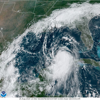
Visible satellite shot of Hurricane Laura 
has the look of a new, and strengthening
and dangerous storm

Without land to disrupt its circulation, satellite images of Laura have "that look," by which I mean the appearance I've seen tropical storms have right before they explode into a major hurricane.

That's the fear right now. As soon to be Hurricane Laura takes aim at the upper Texas coast, it has a very good  chance of becoming a major Category 3 hurricane, with winds over 115 mph and destructive storm surges.

It's very hard to predict future hurricane strength, but there are signs Laura could become an even more dangerous Category 4.  

Worse, at least so far, is that various predictions keep nudging projected landfall Wednesday night further and further west, closer and closer to Houston. 

 The greater Houston metropolitan area has close to 7 million residents.  To some extent, Houston is still reeling from the extreme Hurricane Harvey floods that devastated the city in 2017.

Nobody needs a major hurricane, and Houston in particular does not. 

That's not to say Houston is guaranteed to take the worst of it.  So far at least, the projected path would be far enough east to spare Houston the worst, but we don't know that for  sure. Everybody in that area should be preparing for a major hurricane right now, and hope it hits a little further up the coast toward Louisiana, which has a much lower population density.   

That's not to say I want people near the border of Louisiana to suffer.  And it's not like nobody lives there. For instance, Beaumont, Texas, population about 118,000 could take a direct hit. It's just that avoiding a major hurricane landfall with Laura is now probably a lost cause, so you need to hope for the least bad options

People along the upper Texas coast, especially in low lying areas near the beaches, should be getting out of Dodge now before the weather starts to deteriorate during the day Wednesday. The storm surge from Laura looks like it will be especially nasty. That's especially true for any coastal area just to the east of where Laura makes landfall, because the winds would really shove the water onshore .

STORMS IN NORTHERN UNITED STATES

While not nearly as dire as a major hurricane, the northern United States roughly from Minnesota to Maine and down as far south as the Mid-Atlantic States have been dealing with rounds of severe thunderstorms.  That state of affairs looks to continue through Thursday in at least some places.

Yesterday, here in Vermont and surrounding places, there were pockets of severe storms. The worst of it hit around Whitehall, New York, just over the border from Rutland County, Vermont. 

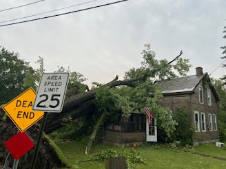
Storm damage in Whitehall, NY Monday

There, rounds of severe storms - one after the other - produced damaging winds and extensive flash flooding around Whitehall. About 20 buildings suffered at least some flooding and some homes in town were damaged by falling trees.

As the storms pushed east into Vermont, that flooding extended into the neighboring towns of Poultney and Fair Haven, Vermont, where several streets and roads were blocked by high water and washouts.  

Elsewhere, quarter sized hail cracked windshields and strong winds blew down trees around Lincoln and Buels Gore, Vermont.  Another strong storm tossed down trees in Grand Isle.

Today that strong cold front we've been talking about will come through, but too early in the day to produce much severe weather in northern Vermont. The more you  head south and east, the greater the chances of damaging winds from storms today. 

The best chances of severe storms today run from around Washington DC up through New Jersey and into southern and possibly central New England. 

The western half of the cold front that's coming through here today will stall from the eastern Great Lakes to the Mid-Atlantic states, prompting a severe weather threat from northern Michigan and down through western New York and Pennsylvania. None of this will affect us here in Vermont.

On Thursday, a wide band of severe weather potential runs from South Dakota all the way to southern New England and the Mid Atlantic States.  Southern Vermont might get into the act, depending upon how far north a warm front manages to come.

So yes, that's rough and tumble, but nothing like Texas and Louisiana are about to go through with Laura  Months ago, they warned us that this would be an active and possibly destructive hurricane season, and it looks like those predictions are coming true.