Matt's Weather Rapport

Vermont weather geek's hodgepodge of weather and climate news and opinion. Often Vermont focused, but taking a national and global approach, with sometimes an appropriate dash of fun, outrage, cynicism and compassion.

About Me

My photo
mjsvta@gmail.com
View my complete profile
Showing posts with label evacuations. Show all posts

Thursday, July 16, 2026

Weather Evacuations: What Can Go Wrong (And Right) When Storms Disrupt Big Outdoor Shows

People being hastily moved from an outdoor venue
to an indoor venue during a high school graduation
ceremony in Orono, Minnesota in early June.
A strong thunderstorm prompted the hasty change in
plans. The move went smoothly, as the school had
 a plan in place for severe weather .
 I attended a high school graduation during early June   in Minnesota for our grandnephew Jonas, who is moving on to college in September.  

We were there for Jonas, of course, but I also got a weather moment, and a weather lesson. It involves evacuations of outdoor events when the conditions get, or threaten to become dangerous. 

The graduation was disrupted by an early summer storm. The school did almost everything right and kept everyone safe and orderly. More on that in a bit. 

Outdoor events are tricky when the weather goes bad.

Weather emergencies have always been a threat to outdoor concerts, festivals and ceremonies. 

Climate change is making this worse, like it's making so many other things worse.

As CBC reports: 

"More and more major cultural, social, business and arts events around the world are being disrupted or canceled by extreme weather events caused by climate change, according to a new study published in the International Journal of Disaster Risk Reduction. 

The study, Mapping the impact of extreme weather on global events and mass gatherings, trends and adaptive strategies details that from 2004 to 2024 more than 2,000 mass gatherings were reportedly disrupted around the world."   

Most of these events happen in the summer, when sudden, fast moving storms often require even faster evacuations. 

Lightning strikes, falling trees and branches, falling debris, collapsing stages and flash floods can happen in a blink of an eye. You need coordinated, well developed plans for this type of thing. 

It doesn't always work out that way. 

WASHINGTON FOURTH OF JULY

Severe thunderstorms forced the evacuation of the 
National Mall during the Fourth of July, creating
chaos as President Trump's team were 
incompetent planning for the event.
It's not always so safe and orderly, as we saw on the National Mall in Washington DC on July 4. 

After a day of dangerous, baking, record breaking heat, severe thunderstorms loomed over the Mall as evening settled in.  

The National Parks Service, fearing lightning strikes, high winds and flying debris, ordered a hasty evacuation of the National Mall. 

Some of the MAGA types in the crowd resisted, predictably arguing that the whole thing was woke liberals in the NPS trying to ruin Donald Trump's big night. 

It was a mess, to put it mildly 

Given the circumstances, NPS wanted everybody to call it a night and cancel Trump's speech and fireworks. 

Per the Washington Post: 

"A senior White House official said Sunday that 'all the entities involved' had recommend calling the festivities off altogether after storms forced the exodus from the Mall.

'When POTUS heard this, he told all involved to invite everyone back in and the speech would take place, even if it meant waiting until 2 a.m,' said the official, who spoke on the condition of anonymity to discuss private deliberations." 

As WaPo notes, the National Weather Service had forecast the record heat days in advance. The severe storms were deemed likely by forecasters three days before the big day. So, the Trump people should have planned for the extreme weather. They did not.  

It appears the National Parks Service did have contingency plans, but moving 100,000 or more people as a storm bore down is not easy. Especially if some of them are unruly.  

However, the whole shebang was designated a National Special Security Event, because the president was making an appearance there.  The designation put the Secret Service in charge of security and emergencies. 

Since management of all federal agencies, including Secret Service, have been reduced to haphazard, incompetent groups because they're run by Trump lackeys and not professionals, things were bound to take a bad turn. 

Especially since the designation meant added layers of security screening for those entering and exiting the Mall.

National Parks Officers were left to deal with the disaster. 

WaPo paints a picture of how it all went: 

"....as skies darkened, lightning flashed and gusting winds swept through the Mall just after 7 p.m., crows of people refused to heed the calls to evacuate. Many had already waited for house in security lines in the heat. 

'Show is over. Pleas keep moving,' one officer shouted to stragglers. 'Rally canceled.' shouted another. Exits back up. Some people complained that it was unclear where they should head, and the scene grew increasingly tense. Social media showed people yelling back at security personnel and National Guard troops flipping over a table to persuade people to flee."

As noted, it would have been better to call it a night. But due to Trump's directive, people had to go through security again. Many people didn't bother.   The whole event was a disappointment, and several people were taken to the hospital, mostly for heat-related illnesses. 

GRADUATION

The Minnesota graduation I attended about a month ago was a completely different world. The crowd was much smaller than at the Mall on the Fourth of July. The weather wasn't broiling hot as it was on July 4 in Washington. 

And the people making decisions on what to do with the weather and the crowds knew what they were doing. 

The high school graduation was held in Orono, Minnesota, an outer suburb about 17 miles west of downtown Minneapolis. 

Before the graduation even got underway,  I checked the radar and found a band of thunderstorms west of Orono, Minnesota. I questioned the decision to go ahead with the outdoor ceremony.

The school decided to go ahead with the outdoor ceremony.  

It was a no-win decision, really. The storms could have dissipated or veered off to the north or south leaving Orono in the clear. That  would have angered participates who preferred a much more accessible outdoor ceremony. 

Or, as how it turned out, the storms kept marching toward Orono strengthening as they did so. As we watched the graduation ceremony, we also saw a walk of dark clouds approaching steadily from the west.  Soon, we saw the storm's shelf cloud, with flashes of lightning flickering beneath it.

That's when the call came to stop the proceedings and move inside. That was about halfway through the ceremony.

This was a modest-sized event with maybe a couple thousand people in a pleasant Minneapolis suburb with sturdy buildings nearby. 

 Pretty much everybody got inside, to the gym, and the graduation continued, almost seamlessly picking up where it left off.

But it did remind me of other outdoor events with larger crowds, bigger storms and poorer planning. Any outdoor event, no matter how mellow, can turn into a deadly fiasco. Even worse than the National Mall Fourth of July mess. 

Some examples:

SUGARLAND

On August 13, 2011,  the popular country band Sugarland was set to play at the Indiana State Fair. As a severe thunderstorm arrived, wind brought down a large portion of the 62-foot tall, 32-ton stage structure. Steel beams and rigging crashed on the crowd, killing 7 and injuring more than 100. 

Forecasters had said severe thunderstorms were expected. However, fair and entertainment officials ahead of the Sugarland did not discuss public safety, just the timing of the show and the fact it was going to rain. 

Sugarland band members were told about the impending rain, and Sugarland said they would go ahead and play, since they often performed concerts in the rain. However, they were not told of the risk of strong winds.

By the time it came apparent a severe thunderstorm with powerful winds was about to hit, it was too late to evacuate Sugarland fans in time before disaster struck.

GLASTONBURY

In other instances, there is not much you can do, The roughly 170,000 people at the 2005 Glastonbury Festival endured an intense heat wave, followed by the most intense storm locals had seen. in 15 years. Lightning cut power, and torrential rains flooded much of the site. In fact, a river burst its banks and sent a torrent of water across a field full of tents.

Somehow, there were few casualties back at that festival, but it really could have been a fatal day.  

Unfortunately, as the Fourth of July National Mall fiasco indicates, some event organizers will not always plan for extreme weather. Or, the allure of revenue might make them make some poor choices.

Next time you go to an outdoor concert, or fair, or festival, check the weather forecast yourself. If it looks really, really iffy, you might want to cancel your plans to be on the safe side. 


Posted by mjsvta@gmail.com at 1:24 PM No comments:
Email ThisBlogThis!Share to XShare to FacebookShare to Pinterest
Labels: danger, evacuations, Fourth of July, graduation, National Mall, outdoors, public events, safety, safety plans, Secret Service

Thursday, January 29, 2026

It Rained Rocks In Hawaii

Tephra or light weight volcanic rock and ash,
covers this car in Hawaii after a Kilauea 
eruption sent debris into populated areas.
 OK, this isn't really a weather or climate story, but close enough. It involves rain, but not the type of rain made up of water, frozen or otherwise. 

This rain, in Hawaii, was rocks. 

The uber-active Kilauea erupted again last Saturday, pushing fountains of lava 1,000 feet into the air. 

But what goes up must come down. And people around the park ended up enduring a tephra storm. 

Tephra is rocks and ash ejected from a volcano. Kilauea regularly discharges both lava and tephra, but the material usually lands on areas that are too dangerous for people. Saturday, unusually light winds made the tephra fall in populated areas near the volcano.

The debris fell on summit overlooks, trails, roads and even some residential areas. A section of Route 11 was closed. 

According to Hawaii News Now

'Some debris close to the size of a grapefruit was reported in Hawaii Volcanoes National Park, including at Uekahuna, the Steam Vents, Volcano House and Keanakako'i, where the rocks were reported to be still hot when they fell.

'I haven't seen this one yet. This is uncharted territory for the Volcano Village,' said Eli Schonbrod, general manager for the Lanikai Brewing Company. 

Colleen Gifford, a cashier at the Kilauea General Store, has lived on Hawaii Island for 40 years, and she she has 'never, ever seen it like this.'"

Some very small tephra - basically bits of ash - was spotted as far away as Hilo, more than 25 miles away. 

Video showed what looked like a black hailstorm, thunking down on car roofs, and littering roadways, parking lots, lawn and roofs with what looked like millions of pieces of crumbled black paper.

Tephra is more light weight than rocks, so it wasn't smashing cars and roofs. It was kind of remotely a storm of falling Brillo pads. But tepha can be sharp, pointy enough to scratch paint. A few people who were out in the tephra storm were scratched enough to bleed slightly. 

Of course, the tephra made a big mess. The day after the eruption, people were seen sweeping and shoveling piles of it away. Plows had to clear one section of a road as if there were a tropical snowstorm. Many roofs remained littered with the stuff. It'll probably come down from the roofs the next time it gets windy or it rains. 

Although more Kilauea eruptions are inevitable, the tephra is unlikely to be a problem again. Almost always, trade winds veer this stuff away from people, as mentioned. This was basically just a one-off. 

Videos

News report of what it all looked and sounded like. Click on this link to view, or if you see the image below, click on that.


Cleanup from the eruption looked like it was quite a chore. Again, click on this link or if you see the image below, click on that. 


Posted by mjsvta@gmail.com at 2:52 PM No comments:
Email ThisBlogThis!Share to XShare to FacebookShare to Pinterest
Labels: evacuations, Hawaii, Kilauea, precautions, tephra, volcano, weird news

Thursday, December 11, 2025

Washington State Flood Update: Record River Crests As Unrelenting Rain Finally Starts To Diminish

A mudslide closed part of Interstate 90 in Washington 
State, hitting some vehicles in the process. Record
flooding continue in Washington today. 
The Great Flood of 2025 is peaking in western Washington today after days of torrential rain from a series of atmospheric rivers have swamped vast areas of the states. 

This is one of those disasters that have so much going on that it's hard to keep track. A network of rivers flow out of the Cascades and Olympic mountains. Within that large river network, numerous areas in these hills got more than 10 inches of rain over the past five days. I saw one report of more than 16 inches.  

The area most under the gun is roughly the size of New England, excluding Maine. Major flooding is occurring or forecast on 17 rivers in the region. Some of those will reach record crests.

The flood in Washington also reminds of the big flood we had here in Vermont back in 2023. All those torrents coming down from those hills and mountains, the river valleys with their small towns and cities filling up with water, landslides obliterating parts of roads.

The only big difference is this is a winter, not summer flood. And I'd say more people are being affected than that horrible Green Mountain State disaster in July, 2023.

Up to 100,000 people in Washington have been evacuated in the Skagit River valley alone. It's a densely populated area about an hour north of Seattle. 

In the town of Mount Vernon, the Skagit River is forecast to rise two feet above the previous record high level. "This is a flood we haven't seen before.....The potential for catastrophe flooding is real," said Mount Vernon Mayor Peter Donovan, as reported by KUOW an NPR-affiliated station in Seattle. 

A flood wall was built around Mount Vernon in 2018. Residents are nervously watching to see whether that wall will be enough. 

There is no good time for a catastrophic flood, but one coming in the weeks before Christmas, especially people whose homes and businesses are destroyed by the high water. 

The good news so far is I haven't seen any reports of deaths, but I fear at least a few people have lost or will lose their lives as more information comes in from flooded areas. There have already been some close misses. 

Two people - one clinging to the roof of a vehicle, another in a tree - were rescued via helicopter in eastern King County, as seen on dramatic video posted on X

Video from Live Storms Media shows water from the Snohomish River overtopping levees and flowing into already flooded roads, homes and businesses. 

Another video by Jonathan Petramala shows residents and business owners of Sultan, Washington rapidly sandbagging and evacuating as water rose rapidly from a nearby river. 

Road travel in western Washington today is trying at best. Even part of Interstate 90 shut down due to a mudslide. Amtrak trains between Seattle and Vancouver are suspended due to flooding. 

Atmospheric rivers hit the Pacific Northwest every winter but this one is a doozy. It originated southeast of China and stretched 1,700 miles to Washington. Atmospheric moisture content over Washington broke December records.  

The atmospheric river is so strong it was able to trigger flooding and flood alerts all the way over into northern Idaho and extreme western Montana. Severe flooding was report in Lincoln County, Montana. 

Despite crossing several mountain ranges, the moisture plume from the atmospheric river is setting off a snowstorm in central Montana.

Remaining moisture from the atmospheric river will ride the jet stream southeastward in a long, narrow path from southwestern North Dakota all the way to southwestern Virginia. 

Back in Washington, the short-term forecast is pretty good  Rainfall is much lighter today. Only scattered showers are in the cards for Friday. Saturday will actually be fairly sunny, which is an infrequent occurrence in western Washington.

But the good news is temporary. Rain will restart Sunday and continue all week. It won't be as heavy as what they just saw, but the daily grind of rain will probably prolong the flooding. 

This is also your reminder that climate change has led to more intense rainfall.  We don't know - at least not yet - how much climate change had to do with the Pacific Northwest flood. But it is consistent with the effects of a warmer world. 


Posted by mjsvta@gmail.com at 1:53 PM 1 comment:
Email ThisBlogThis!Share to XShare to FacebookShare to Pinterest
Labels: atmospheric river, disaster, evacuations, flood, news, Washington

Thursday, November 13, 2025

California Storm Season Off To An Early Start: Flood, Mudslide, Debris Flow Fears Rise

Satellite view this afternoon that is menacing
 California with the threat of heavy rains and floods
Southern California in particular will see very
heavy rain for so early in its wet season
Debris flows near the sites of recent wildfires
are the biggest threat. 
 It's not just the eastern United States having an early start to winter. 

Storms coming off the Pacific Ocean this week are giving California an early start to their annual winter wet season.

The storms over the next few days are raising fears of urban flooding, mudslides and debris flows. Especially near the sites of large wildfires in recent years. 

The fun started today. Flood advisories were up in San Francisco along with coastal and slightly inland areas north to Fort Bragg and south all the way down to Santa Cruz.

 The heaviest rain was moving out of coastal northern California late this afternoon, so some, but mot all  of those advisories have been lifted. 

However, inland, near Sacramento and the rest of the Central Valley, flood advisories were still in effect late this afternoon. 

The heavy rain was moving inland to the Sierra Nevada foothills, where flood watches are in effect. 

Areas of northern California might see two to as much as six inches of rain through tonight. Higher up in the Sierra Nevada mountains, it's obviously colder, so winter storm warnings are up for parts of the Sierra. Some areas could get as much as a foot of snow.

That's not huge by Sierra Nevada standards, but it's pretty good for this early in the season. 

SOUTHERN CALIFORNIA

The real show starts later tonight and tomorrow and continues all week in southern California.

A huge ridge of high pressure is parked over the middle of the U.S. That will make a storm the storm that is trying to move eastward to affects southern California to do so only at a snail's pace. That means sunny L.A. and the rest of southern California are going to feel more like Seattle. 

Which isn't a good thing especially for the fire-scared hillsides of California. 

Los Angeles County has issued evacuation warnings for thousands of people who live near areas burned in recent wildfires. That includes last January's massive Palisades and Eaton fires. The warning is in effect from this evening through late morning Sunday. 

An evacuation warning means people should be ready to evacuate at a drop of a hat. They should spend today gathering documents, medications, important records, and supplies for a possible mandatory evacuation, and have arrangements made for children and pets. 

People who move slowly, like the elderly and disabled, should consider getting out of Dodge today before the rain really starts to fall. 

This all proves that a wildfire disaster isn't over after the last flames are extinguished. There's the risk of further damage - maybe extensive - months or years after the fire. I'll hate to see people whose homes survived the fire only to be wrecked by flash flooding and debris flows. We'll see how that goes. 

The National Weather Service this afternoon hoisted flood watches for all of southern California except for the extreme southeast corner. Most of the watches go into effect late Friday night and continue through Saturday night. 

Some forecasts predict the storms could dump up to seven inches of rain on the mountains north and east of L.A. For lower elevations, two to four inches of rain could fall, but those forecasts could change pretty radically up or down over the next day or two.

Most of the rain would come in two bursts, one tonight and part of tomorrow, the other focused on Saturday. 

At least the early onset of rainfall in southern California is tamping down the risk of more huge early winter firestorms like the region had last year. A very early season southern California rainstorm in mid-October helped. 

October ended with 0.8 inches of rain in L.A., which is above the normal of a half inch. 

Normal rainfall in Los Angeles in November is about 0.8 inches. It hasn't rained there yet this month, but this storm could really get the rainy season off to a good start. Total rainfall tonight through Sunday could reach two to as much as four inches in the Lost Angeles Basin.

The bulk of southern California's rain comes in December through the first part of March. It's obviously too early to know whether this rainy pattern will continue through the winter.

If not, and December and January turn dry, the risk of wildfires could return. In Southern California, it always seems likes it's either too little or too much rain.  

Posted by mjsvta@gmail.com at 2:06 PM No comments:
Email ThisBlogThis!Share to XShare to FacebookShare to Pinterest
Labels: alerts, burn scars, California, debris flows, evacuations, flooding, snow, storm, warnings watches, weather

Monday, August 18, 2025

Hurricane Erin Update: It Maintains Its Power. North Carolina Evacuations As Storm Surge, Tropical Storm Watch Issued

This afternoon's satellite view of Hurricane Erin,
Tropical storm and storm surge watches just
went up for coastal North Carolina. 
Hurricane Erin continues to cause a lot of headaches and worries, especially for a storm that will not make landfall.  

As of 5 p.m. today, Hurricane Erin's top winds were still at 140 mph, up from 125 mph on Sunday. It was catered about 815 miles, south, southeast of Cape Hatteras and moving toward the northwest at 10 mph.

A tropical storm and storm surge watch were issued late this afternoon for much of Cape Hatteras/the Outer Banks as winds there should reach at least 39 mph when Erin makes its closest approach Wednesday night and Thursday.

To nobody's surprise, evacuation orders went up for the Outer Banks of North Carolina.  Hurricane Erin will not make direct landfall in the United States. But the power of Erin, and its expanding wind field, will stir up enormous waves.

Under a Dare County, North Carolina emergency order, tourists to the outer banks were told to start getting out by 10 a.m. today. Permanent residents need to start leaving by 8 a.m. tomorrow.  Long lines of cars could be seen today on Route 12, heading north off Hatteras Island to destinations inland. 

The problem for North Carolina is that Hurricane Erin is already larger in size than most hurricanes, and it's getting even bigger.  As of late this afternoon, hurricane force winds of 74 mph or more extended out 80 miles from the center and those tropical storm winds go out 230 miles from the center. 

Although Erin is generally moving in the direction forecasters have said for days it would, the hurricane will pass a little closer to Cape Hatteras than meteorologists thought a few days ago. So that makes the impacts a little worse than originally thought. 

All these factors mean waves of 15 to 20 or more feet are forecast to slam into the Outer Banks, which would cause terrible erosion, flooding and destruction of coastal homes and other buildings,

The only real way in or out of the Outer Banks is Route 12. Emergency managers are sure the road will be inundated and impassable as Erin blows by.   If anybody stays behind, emergency responders won't be able to reach them. That's why they're kicking everybody out of the Outer Banks. 

In Rodanthe, North Carolina, at least two homes are in grave danger of collapsing into the ocean when Erin passes through. More than a dozen homes have fallen into the ocean since 2020, including six last year. 

Sea level rise and increasingly ferocious storms due to climate change are at least partly to blame for all this. Additionally the land in the region is slowly sinking as well.

There are unconfirmed reports of 50 rescues at Wrightsville Beach, North Carolina today already due to high surf and rip currents. 

Erin might be weakening a tiny bit late this afternoon, thanks to some dry air the hurricane gulped in today from the north. But the weakening will either stop, or be so slow as to not make a difference on how it affects North Carolina, or anyplace else for that matter. 

Tropical storm conditions are already hitting or soon will hit the Turks and Caicos, and much of the Bahamas. It'll also eventually get stormy in Bermuda. 

In Puerto Rico, the outer rain bands of Erin were enough to bring winds and rains heavy enough to cut power to 50,000 customers. The Virgin Islands also dealt with gales and flooding Sunday.

Dangerous surf, rip currents and waves are expected up and down the entire United States East Coast and most of Canada's east coast as well this week.  


Posted by mjsvta@gmail.com at 2:18 PM No comments:
Email ThisBlogThis!Share to XShare to FacebookShare to Pinterest
Labels: Bahamas, Bermuda, danger, East Coast, evacuations, flooding, forecast, Hurricane Erin, news, North Carolina, waves, wind

Sunday, January 12, 2025

California Fire, Week 2: More Wind, More Fire, More Heartache,

A firewhirl forms this week in
the giant Palisades fire in
Los Angeles County, CA.
Lately this blog feels like it's turning into all California wildfire, all the time.

But this is such a big deal, such a wide ranging, incredible national disaster that you can't ignore the updates, the changes, the effects it has on all of us.  

Nobody can cover everything in one article or a few, of course. But it's important to stay at least a little informed about what's happening.  

At last check this morning, the death toll from the ongoing California fire calamity keeps climbing, and at last report was up to 16.

As the fires continue to rage, they'll find more bodies in many of the hard hit areas. Now that the ashes are beginning to cool in some hard hit areas, search teams say they will bring in cadaver dogs to do systematic grid searches in destroyed neighborhoods.

The above paragraph is easily among the most grim I've ever had to write in this blog. 

NOW WHAT?

Meanwhile, an incredible number of people are watching and waiting to see what the fires do next. At least 150,000 people are still under mandatory evacuation orders. Naturally, pretty much all of those evacuees want to go back to either see the ruins, or if they're lucky, return home. 

That desire has led to frustration as people are blocked from going back due to the dangers.  Authorities said there are downed power poles, live electrical wires, smoldering fires and unstable debris. 

Police initially worked with people to provide police escorts for those who wanted to go back to retrieve medications and pets. But they're stopping that because the number of people requesting the escorts is overwhelming. 

Which of course doesn't help for people worried about pets potentially starving to death in evacuated homes, or people skipping necessary medications. 

I hope that gets straightened out soon.

A Volkswagen bus appears to be the only thing left in
this California neighborhood in this Associated Press photo.
Winds temporarily diminished Saturday afternoon, though they picked up again early this morning. Another lull is in the forecast later today, and that should help firefighters with containment efforts ahead of the next blast of wind. 

The forecast for strong, arid winds in the fire zone over the next several days continues to look bad, possibly even worse than previous forecasts.

 At least now, there's more resources in place. Armies of firefighters from as far away as Idaho, Washington, New Mexico and the nations of Mexico and Canada are in southern California battling away. 

According to the Associated Press:

"Crews from California and nine other states are part of the ongoing response that includes 1,354 fire engines, 84 aircraft and more than 14,000 personnel."

I noticed in one threatened Brentwood neighborhood on Saturday, there was a fire truck parked in every third driveway.

The firestorms are likely the costliest and U.S. history. One estimate from AccuWeather pegged damages so far at between $135 and $150 billion. 

The strings of disasters - made worse than they otherwise would be by climate change - are likely a drag on the United States economy. 

The U.S. suffered 27 weather disasters in 2024 each costing more than $1 billion, with a total cost of $182.7 billion, the fourth highest on record, according to the National Centers for Environmental Information. Assessments of these disaster are still ongoing, so that figure could rise. 

Everybody is of course watching what's going on in California, and there's obviously a market for video of this terrible event. I keep posting videos of the fires, so there you go.

Unfortunately, there's always people who want to monetize the disaster. Some people are flying drones into the fire zone, which is both illegal and dangerous. Unauthorized drone incidents into the fire area are now "well into the double digits," a FBI official said. 

One drone hit one of those big Super Scooper planes from Quebec. They're those big planes that you might have seen skimming the Pacific Ocean off of Santa Monica to fill tanks with water, then flying into the disaster zone to dump the water onto the flames. 

These planes are pretty damn cool. Unfortunately, the drone that hit the plane put that critical piece of firefighting equipment out of commission. I'm just glad the crew on that plane were able to land it safely.  

There's so much more to report and update, and watch this space for some of the more interesting and pertinent ones. 

VIDEOS

The best sources of news about the California fires is local.  Los Angeles television station KTLA has been an especially excellent source. This Saturday evening newscast is a master class in useful information, insights, emotion and comprehensive reporting. Click on this link to view or if you see the image below, click on that. 


A sad, post-fire drive down the Pacific Coast Highway in Malibu. You see pockets of intact buildings, but most of them for  miles are gone. Click on this link to view or of you see the image below, click on that:


Posted by mjsvta@gmail.com at 11:40 AM No comments:
Email ThisBlogThis!Share to XShare to FacebookShare to Pinterest
Labels: California, deaths, dry., evacuations, forecast, high winds, news, tragedy, wildfires

Tuesday, October 8, 2024

Tuesday Evening Hurricane Milton Update: Grim Monster Continues Push Toward Florida

 Hurricane Milton remains a monster. 

Visible satellite view of Hurricane Milton late Tuesday
afternoon. Click on the pic to make it bigger and easy to
see. The main central swirl around the eye looks like a buzzsaw.
After re-arranging its eye during the morning and losing just a slight bit of steam,  Hurricane Milton reasserted itself and gained almost all of its previous power. Plus, it's a larger storm now. 

As of late this afternoon, the National Hurricane Center said Hurricane Milton was a Category 5 with top winds of 165 mph. It was 480 miles southwest of Tampa, Florida and heading in that general direction. 

Yeah, it sucks to put it mildly. 

The forecast track has shifted southward by the tiniest smidge. That raises some tentative hope that it will pass a little south of Tampa Bay. 

If that were to happen - and there is absolutely NO guarantee that it will - the storm surge in Tampa Bay would be a little less than the current dire 10 to 15 feet. But don't count on it. Plus, "a little less" is still a huge danger. 

The "cone of uncertainty," which is the zone in which Hurricane Milton could make landfall, could be as far north as a spot 60 miles north of Tampa. Remember, a path over or just north of Tampa Bay would yield the worst storm surge possible in Tampa Bay, due to the topography of the land around the bay. 

On the other hand, Hurricane Milton could come ashore as far south as Cape Coral, about 100 miles south of Tampa.  

In other words, anybody who is in an evacuation zone in Florida and hasn't left yet should flee now if not sooner. 

If this evening's projected path is spot on, it would come ashore near around metro Sarasota, which has a population of about 835,000.

Also remember that Hurricane Milton is expanding in size, and that trend will continue. As of late this afternoon, tropical force storm winds extend out 140 miles from Milton's eye. That area could double by the time Hurricane Milton is approaching Florida. 

Late Tuesday afternoon forecasts have tropical force winds of 39 mph or more, and the beginnings of a storm surge should be starting not long after noon tomorrow on Florida's Gulf Coast. It will be too late to get out of way of the storm tomorrow. 

By the time Hurricane Milton reaches the Florida coast, upper level winds and an approaching front from the north will be trying to weaken the storm. But it will be too little, too late. Top winds are forecast to be 125 mph with higher gusts at landfall..

And a last minute reduction in wind speeds won't translate to a lower storm surge. 

Often when a hurricane is beginning to weaken, the south side of the storm has the higher winds. This time, it might be the north side that has the most ferocious winds. So even if the center of Milton passes a little south of Tampa, the winds would be super destructive, even if the storm surge ends up being a little less than the more dire forecasts.

So Tampa really can't win here. 

Hurricane force winds will blast across all of central Florida coast to coast overnight Wednesday and into Thursday. 

WHAT THIS MEANS FOR PEOPLE

Like I mentioned, people who did not evacuate from the storm surge area are in deep, deep trouble. 

Much like in Helene, Florida officials told people who choose not to evacuate from vulnerable areas to mark their names and date of birth on their arms with permanent marker so officials can identify their bodies later. 

Emergency managers said they were able to conduct a few water rescues in Florida during Hurricane Helene's storm surge. That won't be the case with more powerful Hurricane Milton. They told residents if don't leave by noon Wednesday, they are on their own. Nobody will come to rescue them when the water rises. 

Of course, I have to wonder about the welfare of some of the people who heeded warnings and evacuated. Some people don't have the means to evacuate from danger zones are doing. What if you don't have a car? How do you escape?  Just the cost of travel, accommodations in an evacuation can easily cost $500 or more.  A lot of  people don't have that kind of money lying around. So do they hunker down and hope for the best? 

Do people deserve to die in a hurricane for the "sin" of not having enough income?

There are shelters that have opened in public buildings on high ground for some of these storm surge refugees, but is there room for all of them?

Much of Florida is now shutting down as the storm bears down.

Tampa International Airport closed this morning. Orlando's airport shuts down tomorrow morning. Walt Disney World and Universal in Orlando as of this afternoon were staying open, perhaps unwisely, though campgrounds in wooded areas are closing for fear of falling trees.

As of this evening, nobody is allowed access to barrier islands off the southwest Florida coast.  If there are any stragglers still in homes on the barrier islands, they'll still be allowed to flee. But time is running short. 

President Biden canceled planned trips to Germany and Angola to monitor the hurricane. 

Downtown Tampa looked like a ghost town by Tuesday afternoon. The normally bustling area was almost devoid of cars and pedestrians, and businesses were either closed or shutting down operations until after the storm. 

I haven't mentioned climate change in most of these updates as I'm mostly focusing on the immediate impacts of this storm. But many aspects of Hurricane Milton are at least consistent with climate change. I'll get into that in a future post, once we catch our breath for this latest sure to be deadly and expensive calamity. 


Posted by mjsvta@gmail.com at 3:27 PM No comments:
Email ThisBlogThis!Share to XShare to FacebookShare to Pinterest
Labels: category 5, danger, evacuations, Florida, Hurricane Milton, path, Sarasota, storm surge, Tampa, updates, warnings, worries

Today Is Last Chance For Floridians To Flee Or Button Down From Hurricane Milton Onslaught

Screen grab of video by Jonathan Petramala of residents
jamming Tampa area freeways to flee Hurricane Milton.
 Hurricane Milton overnight has taken its expected turn toward the Northeast and is now ready for its final approach between  now and Wednesday night to strike hard against the Gulf Coast of Florida.

You're going to hear a lot about how Hurricane Milton has "weakened" or "is weakening" as it approaches the Florida coast. 

That gives a false sense of safety regarding this extremely dangerous storm.  I prefer to say that Hurricane Milton is "transforming."

We've already seen the first phase of that near-constant transformation process overnight. 

Last evening,  Hurricane Milton had incredible top winds of 185 mph surrounding a teeny tiny pinhole eye that was only maybe three or four miles across. Hurricane force winds extended out only 30 or so miles from that eye, with tropical storm force winds extending out 80 miles from the center. 

So it was an extremely powerful, but tiny storm by hurricane standards. 

By 7 a.m. today, top winds with Milton were "only" 145 mph.

Um, yay?

Not really.

Hurricane Milton was going through what is known as an eyewall replacement cycle, which is extremely common with intense hurricanes. 

What happens is, the ring of intense storm and winds immediately surrounding the tiny eye of Milton began to collapse, while a new, larger ring of those intense storms began to form. This ring of chaos is called the eyewall. 

Winds might be a little lower but still intense with
Hurricane Milton this morning, but the storm is larger
in size than yesterday.  A larger storm can create
bigger storm surges.

The end result is an eye that is much larger in diameter than before.  The highest winds usually end up being a little lower after this process, sometimes only temporarily. That's because the energy and wind distribution is larger after this eyewall replacement cycle. 

As of the 4 a.m., this cycle was just going on. Hurricane force winds still extended just 30 miles from the center of Milton, but tropical force wind now extends out 105 miles.

The expansion of Milton has begun.

This has long been expected by forecasters and it's bad news.  A larger storm means it can push more water toward the Florida coast. The more water the storm pushes, the worse the storm surge would be. 

Since Hurricane Milton is expected to keep getting bigger until landfall, you can see why forecasters are still worried about a unsurvivable storm surge in or near Tampa Bay when Hurricane Milton makes landfall Wednesday night.

The surge will start well before the eye of the hurricane arrives, so that will cut off evacuation routes pretty early. 

This is all why you saw a stampede of people and cars wisely leaving the Florida coastline Monday, and you will continue to see that today. 

ON THE GROUND

If there was any benefit to Hurricane Helene nearly two weeks ago, is it put the fear of God into Florida residents. 

Areas in and near Tampa Bay were devastated by Helene's storm surge, and that surge wasn't even nearly as bad as the forecasts for Milton.

With the memory of Helene still fresh, people are getting out of Dodge in a hurry. Or at least trying to. There were massive traffic jams as people fled, and gas was starting to get in short supply.

Truckers and government agencies are rushing gasoline and diesel fuel to the Tampa region to make sure everybody has enough gas in the tank to flee.

Another huge problem with Hurricane Milton is actually a Hurricane Helene hangover. There are massive piles of debris lining the streets where the prior storm surge struck.  Crews are frantically trying to remove this debris before Milton hits, but there's no way they'll get rid of a lot of it. 

This debris will become destructive missiles in Milton's high winds, or become battering rams when the storm surge hits, causing even more damage to existing buildings than a storm surge alone. 

Demographic changes and existing topography are making this storm dangerous too. This might be the worst storm to hit the Tampa Bay region in about 100 years. Not many people lived there a century ago, really. Now it's changed

As the Washington Post explains:

"Tampa Bay has seen massive development in recent years. Census records show that from 1970 to 2020, the Tampa-St. Petersburg-Clearwater metropolitan area grew by more than 187 percent. Other nearby urban areas also saw substantial expansion. 

The region is at particular risk to storm surge because of its topography. Experts have warned that if a storm pushed water into Tampa Bay, it could essentially get trapped into too small a space, sending storm surge levels higher."

The Tampa metropolitan area has about 3.3 million people. A lot of them have to get out of the way of Milton.  That's why it's so chaotic there.

Some people are reluctant to evacuate.  But Tampa Mayor Jane Castor had some blunt words for residents during a CNN interview: "If you choose to stay....you are going to die," she said. 

 Here's another complication for the region: A large number of elderly people live around Tampa, Clearwater, Sarasota and those areas.  It's Florida after all, where so many people go to retire.  It's a lot harder to move an elderly person with major health issues out of the way than it is to move others.  So that's a problem that will have to be overcome today. And quickly. 

WHAT'S THE TARGET?

We know Hurricane Milton is almost guaranteed to be a formidable storm once it reaches Florida. But who gets it the worst?

The general consensus is still that it will arrive somewhere near Tampa. But it could still strike further north, like above Clearwater. Or the eye could make it ashore near Sarasota, Port Charlotte or even Cape Coral.

The whole central Gulf Coast of Florida is in for a terrible storm surge. But it matters where it will be the nastiest.

All the scenarios are bad, but the worst case is if Hurricane Milton comes ashore right over Tampa, or just a little north of that. The middle and points immediately south of the eye at landfall will be in for the roughest ride of all, and the worst storm surges. 

Of course, the storm surge is the biggest but not the only hazard with Hurricane Milton. Destructive winds will slash across all of central Florida all the way to the Atlantic in places like Daytona Beach and Melbourne. 

Inland Orlando is anticipating gusts to at least 95 mph if Hurricane Milton stays on its expected track. Flooding unrelated to storm surges is inevitable, too, given that up to a foot of rain might fall across central Florida with this hurricane.

Once Milton crossed over Florida, it will blast eastward out into the Atlantic.  Somewhat surprisingly, it's expected to fall apart once it gets well off the east coast of Florida.  Strong upper level winds, which will begin to degrade the hurricane just as it starts to reach Florida Wednesday night, will really go to town and destroy the storm once it's past Florida.

For the Sunshine State, that is unfortunately too little, too late. 


Posted by mjsvta@gmail.com at 5:26 AM No comments:
Email ThisBlogThis!Share to XShare to FacebookShare to Pinterest
Labels: changes, danger, evacuations, forecast, Hurricane Milton, news, storm surge, update, warnings

Monday, October 7, 2024

Monday Evening Update: Monster Milton Has Floridians Fleeing Grave Danger

Satellite view of Hurricane Milton late this afternoon.
If you click on the image to make it bigger and
easier to see, you'll notice a tiny eye, which is
often what you see in extremely strong hurricanes.
The clouds around the eye are arranged like a 
stadium would look like, another sign of a powerful storm
Hurricane Milton spent the day making history and also making Floridians, emergency managers and meteorologists quake in their boots.  

By late this afternoon, Hurricane Milton has strengthened to a monster Category 5 storm with top winds of 180 mph. (A hurricane needs to be at least at 157 mph to reach Category 5, so Milton is there by a long shot.

Only five Atlantic Ocean hurricanes on record have had stronger winds than Milton and three others were as strong. And Milton could get stronger yet before factors come together to cause a gradual weakening.

Again, I hate to use the word "weakening" because this is an enormous threat to Florida's Gulf coast. Just ask the experts: 

"If the storm stays on the current track, it will be the worst storm to impact the Tampa area in over 100 years," the National Weather Service office in Tampa, Florida warned.

"Unless we get extremely lucky, Milton will be one of the biggest hurricane disasters in history," said Bryan Norcross, one of the nation's leading hurricane experts. 

Meteorologist John Morales, with decades of hurricane forecasting under his belt, became emotional when explaining the hurricane to viewers today. It's that bad.

The overall forecast for Hurricane Milton hasn't really changed since this morning, despite it being even stronger than almost any forecast had anticipated.

It's going to scrape by the northern Yucatan peninsula tonight, raking that coastline with hurricane force winds.

Milton is just about making its turn toward the northeast for its eventual destination in Florida. At the strength it's at now, we can expect some variations in its strength before a weakening trend begins Wednesday.

The storm does have an opportunity tomorrow to get even more intense than it is now.

Hurricane Milton as powerful as it is, is relatively small in size. Hurricane force winds late this afternoon only extended out 30 miles from its tiny intense eye.

After Hurricane Milton peaks in intensity and begins to weaken a bit, the storm will also grow much larger. That's bad, because it will be able to push more Gulf of Mexico water into the Florida as a giant storm surge ahead of and during its expected landfall Wednesday night. 

If Milton goes over or a wee bit north of Tampa, the storm surge could be up to 15 feet tall. That's double what Helene managed less than two weeks ago, causing over a $1 billion in damage in Florida and causing 12 deaths. 

If Milton goes a little south of Tampa, the storm surge there will be still be catastrophic, and those potentially 15 foot storm surges could instead hit places like Sarasota or Fort Myers. 

One small piece of news about Hurricane Milton that's at least vaguely gratifying. News footage today has been showing a mass exodus out of the Tampa metro and nearby areas under the greatest threat from the storm.

Almost all those outbound vehicles represent potential lives saved because their occupants are driving away from the unsurvivable storm surge zone.

MILTON STATS

Some stats I've come across that explain why meteorologist were agog at how fast Hurricane Milton strengthened and how strong it got.

Milton's top wind speed increased by 90 mph within 24 hours. Only Felix in 2007 (100 mph in 24 hours) and Wilma in 2005 (105 mph in 24 hours, were faster, said hurricane and storm surge expert Michael Lowry. 

Milton is the second Category 5 hurricane this year (Beryl was the first one). It's only the 8th hurricane season to have two such strong storms. The others were 1932, 1933, 1961, 2005, 2007, 2017 and 2019, reported hurricane researcher Michael Ferragamo

Notice how four of those years were pretty recent. Makes you think those increasing water temperatures out there due to climate change might be one reason (but probably not the only reason)why we have such strong storms.

Another oddity about Milton is its the only known Category 5 hurricane since at least 1851 that moved toward the southeast. noted atmospheric scientist Tomer Burg. All the others headed in other directions, mostly toward the west or northwest.  

This is already a historic storm, and will very likely be one of the worst on record for the United States. It's a scary thought that perhaps by Wednesday or Thursday, we will have had two of the worst hurricanes hitting the U.S. within two weeks of each other. 

Posted by mjsvta@gmail.com at 3:29 PM No comments:
Email ThisBlogThis!Share to XShare to FacebookShare to Pinterest
Labels: danger, evacuations, Florida, forecast, Fort Myers, Hurricane Milton, intense, news, records, Sarasota, storm surge, Tampa

Monday Morning Hurricane Milton Update: Florida Screwed, But Exactly Where?

This morning's visible satellite view shows dawn breaking
on incredibly intense Hurricane Milton. Click on the pic
to make it bigger and easier to see. That bumpy swirl
in the middle is a sign of an extremely powerful storm
 Hurricane Milton continue to power up in the Gulf of Mexico overnight, with top winds this morning  reported at 150 mph.

That's up from 80 mph Sunday afternoon.  

Veteran hurricane watchers are stunned by how fast Milton has been strengthening. I'm barely able to keep up with it. I started the morning saying top winds were 100 mph. By 7 a.m. I had to change that to 125 p.m. By 9:15, just before posting this, I had to say 150 mph. 

It should reach Category 5 soon before it brushes the northern coast of Mexico's Yucatan peninsula to get disrupted ever so slightly. But it will bounce back for awhile and just be amazingly strong

This will go down in history as one of the strongest hurricanes on record in the Gulf of Mexico. 

Hurricane Milton is still forecast to weaken a bit on approach to the Florida peninsula on Wednesday, but that's not saying much.  As we said yesterday, that weakening toward the time of landfall shouldn't make anyone relax.

It'll still be a super dangerous hurricane when it smacks into Florida.

 Exactly when will it hit?

The consensus has been Wednesday, but there's variations on the expected forward speed of Milton. Will it be midday Wednesday? Or will it slow down and not come until night or even early Thursday? We're not sure, and that has implications as to how fast coastal residents need to be moved out of harms way because of the expected storm surge. 

Also, where will landfall in Florida hit? Hurricane Milton seems to be getting more influence from various dips and bumps in the overall upper level wind flow. 

It's been actually moving toward the east-southeast, and is now expected to brush past the northern Yucatan Peninsula in Mexico. If these southward trends continue, its interaction with land in Mexico might briefly disrupted Hurricane Milton's strengthening process,

A nice hope, but don't count on it. Plus, Milton would recover as it turns northeastward starting tomorrow. 

That slight southward shift in Milton's path today is actually complicating forecasts on how far north it will turn as it sets its sights on Florida. 

A southward dip in the upper level wind flow in the western Gulf of Mexico wants to create a corresponding northward bump in that wind field near Florida. That's why Hurricane Milton will take a turn toward the northeast.

How big will that northward bump get? We don't really know. For now, the forecast landfall is for near Tampa, but could be as far north as Cedar Key in northwestern Florida or as far down as southwestern parts of the state south of Naples. 

For those who are worried, any northward deviation in the forecast track still won't affect the flood disaster zones of north Georgia, South Carolina, Tennessee and especially North Carolina. Those areas should expect no effects from Milton. In fact, that region mercifully will have very little or no rain for the next seven days. 

We shouldn't focus too much on the exact Florida landfall spot.  A wide area of Florida's Gulf Coast will be engulfed in an intense storm surge. Much of the rest of Florida can expect very damaging winds, made worse by all the debris left over from Helene blowing around. Oh, and expect lots of inland flooding, too

In other words, at least part of Florida is screwed. Again.

When Helene blew by less than two weeks, a highly destructive and deadly storm surge reached seven feet in Tampa Bay.  Current forecasts in Tampa Bay indicate Milton would create 8 to 12 feet of storm surge. 

Tampa Bay is oriented such that if Hurricane Milton goes over or a slight bit north of Tampa, surges would be forced by topography to really pile up in that bay, hence the worry. If Milton goes south of Tampa, it won't be nearly as bad.

But then if that happens, places like Fort Myers Beach, flattened by Hurricane Ian in 2022 and damaged by Helene at the end of September, would be devastated again. 

Anywhere in Florida where there's a storm surge risk, people ought to be getting o

In any event, this will be the third time this year Florida has been hit by a hurricane. They can't take much more. 

Posted by mjsvta@gmail.com at 6:31 AM No comments:
Email ThisBlogThis!Share to XShare to FacebookShare to Pinterest
Labels: danger, evacuations, flooding, Florida, forecast, Hurricane Milton, storm surge, wind

Sunday, February 4, 2024

California Floods/Wind Much Worse Than The Usual Winter Storms Out There

Satellite photo this morning shows the massive 
storm plowing into California. Severe flooding 
and wind damage is likely out of this one, 
 As of this morning, California was just starting to endure perhaps the worst storm in years.

Practically the entire state is under the gun for either life-threatening flooding and mudslides, very damaging winds, and in the mountains, feet of snow. 

Winter storms and atmospheric rivers regularly smack into California, causing flooding, mudslides, wind damage and mountain blizzards. 

Most of the state is receiving heavy rain from this, but the worst of the downpours will probably hit southern California. 

"All systems are go for one of the most dramatic weather days in recent memory," the National Weather Service office in Los Angeles wrote in their Sunday morning forecast discussion. 

 NOAA's Weather Prediction Center has put large parts of southern California, including all of the Los Angeles basin and pretty much all the nearby mountains are under a high risk of flash floods.

That's a rare designation that only happens a handful of times a year anywhere in the nation. A high risk of flash floods designation is typically issued on only about 4 percent of the days out of the year. But high risk days yield 39 percent of all annual flood deaths and 83 percent of all annual flood damage in the U.S.

An example: Vermont was under a high risk flood designation this past July 10 and look what happened.

Lower elevations around Los Angeles were expecting three to six inches of rain with six to 12 inches in the foothills and mountains. 

This is way more than enough to trigger mud and rock slides and debris flows, especially near areas that had wildfires. Santa Barbara County is expected to get some of the heaviest rain, and several neighborhoods there were evacuated ahead of the storm because of the dangerous risk of debris flows.

The evacuations include parts of the ritzy small town of Montecito, where a 2018 mudslide killed 23 people and destroyed at least 100 homes. 

Although flooding is possible in central and northern California, the bigger risk there is high winds. Officials were anticipating many power outages, downed trees and some structural damage as winds gust over 60 mph. Stronger winds were forecast near the coast.

The first-ever Hurricane Force Wind Warning has been issued for the California coastal waters near Big Sur. 

The National Weather Service office in Sacramento had this forecast and advice for people in the Sierra Nevada range:

"For the Sierra, snow accumulations of 2 to 4 feet are expected, with up to 6 feet at the higher mountain peaks. Southerly winds gusting as high as 65 mph will be possible......Heavy mountain snow and strong, gusty winds are expected to bring difficult to impossible mountain travel with snow-covered roads, chain controls, road closures and whiteout conditions at times."

Considering the strength of the storm and the large population its hitting, I  have a feeling this storm will end up being yet another storm that causes at least $1 billion in damage. 

 By the way, longer range forecasts so far have this storm falling apart well before reaching Vermont. It might eventually produce clouds and perhaps a little light rain or snow next weekend. 

Of course, I'll  have more on this California storm as it develops. 


Posted by mjsvta@gmail.com at 9:20 AM No comments:
Email ThisBlogThis!Share to XShare to FacebookShare to Pinterest
Labels: California, danger, debris flows, evacuations, forecast, heavy snow, high winds, news, risk, severe flooding, storm, warnings

Tuesday, August 29, 2023

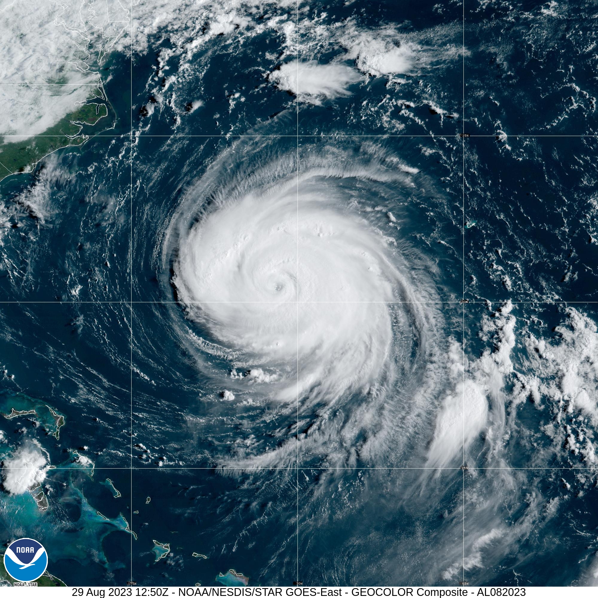
Florida Bracing For Hurricane Idalia, Evacuations Ongoing Ahead Of Destructive Storm Surge

Satellite photo of Hurricane Idalia this morning shows
it beginning to take on "that look" of a potentially
very powerful storm.
Thousands of people are fleeing western and northern Florida today, and for good reason. 

What was Tropical Storm Idalia has strengthened into a hurricane, with top winds of 80 mph as of 7 a.m. this morning. Now, the meteorological ingredients have come together that could further strengthen this thing into a monster. 

Thunderstorms have consolidated around the center of Idalia. There's a lot of lightning in those storms. Upper level winds above the hurricane have relaxed. The water beneath the storm is at near record warmth. The combination sets the stage for rapid intensification today from a middling hurricane to a powerful, dangerous one. 

Forecasters expect Idalia to become a major Category 3 storm with top winds of 120 mph by the time it hits land tomorrow. It could even get stronger than that.   That's unquestionably bad, of course, but the worst part of any big hurricane is the storm surge. 

The low air pressure of a hurricane lifts the water, and the intense winds shove the water onshore like a massive bulldozer, taking down anything in its path. Huge waves with the surge just make everything that much worse. 

The National Hurricane Center warnings concerning the storm surge are worrying to say the least: They warn of "widespread deep inundation, with storm surge flooding greatly accentuated by powerful battering waves. Structural damage to buildings, with many washing away. Damage greatly compounded from considerable floating debris. Locations may be uninhabitable for an extended period."

I found it a bit disconcerting that already there was minor coastal flooding in communities like St. Petersburg, Florida on Monday, well in advance of the storm. The storm center was a full 175 miles west of Key West this morning and there was quite a bit of coastal flooding going on there. 

Officials are urging people to high tail it out of danger zones now if not sooner, before escape routes are cut off by rising water. 

All this while the sun is still shining on the Hurricane Idalia danger zone.  But the sun won't shine for long. Outer rain bands and squalls from Idalia should start moving over the area by this afternoon and evening. 

The area under a storm surge warning is huge, running from south of Sarasota in southwestern Florida, all the way northward along the rest of the west coast of Florida and on into the state's panhandle to a little east of Panama City. Evacuation orders are in effect for 21 Florida counties. 

The center of the hurricane, and its worst destruction is still expected to hit land where the coast of Florida starts curving westward into the panhandle. But there's still questions about whether it will shift east or west, so Idalia could strike closer to Tampa or closer to Panama City. 

It's always important to note that even if Hurricane Idalia tracks exactly where forecasts now think it will go. The storm surge will hit a broad area of coastal Florida. As I mentioned yesterday, the geography of the coast line and the path of Idalia will ensure that a storm surge is shoved into Tampa Bay, and the water will have nowhere to go with all that pressure from the southerly gales as Idalia blows past.

In the hardest hit zones, the storm surge could go up to 12 feet. Tampa Bay is expecting a four to seven foot storm surge. 

Torrential rains will also add to the mix, causing inland flooding. Water trying to drain from the land into Tampa Bay will have nowhere to go because of the storm surge blocking the way. 

President Biden has already approved an emergency declaration for Florida. Everyone is battening down. Tampa International Airport closed at midnight last night, and won't reopen until after the storm and damage is assessed. 

The hurricane warning affects 13 million people. Forty-six of Florida's 67 counties are in a state of emergency.  Schools are unsurprisingly closed throughout the western  half of Florida.  You can tell people there are expecting a biggie.   

Meanwhile, Hurricane Franklin swirls off the southeast
U.S coast, and west of Bermuda.

After striking Florida, Idalia will cruise through Georgia and South Carolina as a tropical storm, then head out to sea off the southeastern North Carolina coast by Thursday. From there, its future is uncertain.

HURRICANE FRANKLIN

We have to mention Hurricane Franklin, which as of this morning was very roughly half way between Bermuda and the southeastern coast of the United States.

 It's a monster that I think peaked yesterday, thankfully without hitting land.  Its top winds reached to nearly 150 mph and in satellite imagery took on the look of a classic powerful hurricane.

Its center will miss land and Franklin will eventually die in the cold waters of the North Atlantic. But being such  powerful storm, it's causing and will cause dangerous rip currents from Miami, Florida all the way north along the U.S. and Canadian east coasts to Newfoundland. 


Posted by mjsvta@gmail.com at 6:10 AM No comments:
Email ThisBlogThis!Share to XShare to FacebookShare to Pinterest
Labels: danger, disaster, evacuations, Florida, Franklin, hurricane, Idalia, news, warnings

Friday, August 18, 2023

Latest Canadian Wildfire Nightmare: Yellowknife NWT Evacuated, British Columbian City Endangered

A long line of vehicles on Highway 3 leading out of 
Yellowknife, Northwest Territories, Canada. The 
entire city of 20,000 was evacuated due to an
advancing wildfire. Photo by Pat Kane/Reuters.
 Canada's year of wildfire devastation just keeps going on, as major new fire crises are hitting the nation's northwest corner and also its westernmost province.  

The last of the 20,000 or so residents of Yellowknife, Northwest Territories were on their way out of town Friday as a huge wildfire bore down on that city. 

Yellowknife is known for its frigid winter climate, but the story now, like most of Canada has experienced at one time or another this year is fire.

As the massive fire bore down on Yellowknife, and local authorities this week decided the best course of action was to get everyone out by Saturday, when the wildfire is expected to arrive. 

As you can imagine, abruptly evacuating a city of 20,000 is pretty chaotic.  Plus, it's a major hub for all the little villages up in that corner of Canada.  It looks surprisingly large for the population in photos, complete with a busy downtown and high rises. A huge region does its commerce in Yellowknife. So the evacuation is incredibly disruptive  to say the least, even if ultimately, no homes there are destroyed by the fire. 

A majority of Yellowknife residents have been able to drive out of the city despite the nearby fires and areas of dense smoke. The traffic was stop and go, however, as motorist made their way through smoke, and carefully had to pick their way through areas already burned over. 

People without easy access to cars, and the elderly or those with health problems and some families were scrambling to get flights out of Yellowknife.

Flights out of Yellowknife got bogged down by smoke and other weather conditions and not everybody who wanted to leave on planes Thursday could.  So people who waited for hours at the airport were told to go home and come back Friday morning. About 21 flights with room for about 2,000 people were scheduled to depart Yellowknife on Friday. 

Weather conditions are ominous for Yellowknife. A passing storm system might produce a couple of scattered rain showers today and tonight, but those won't be nearly heavy enough to disrupt the fires.

Strong winds behind the storm gusting to 30 mph from the northwest and west, would drive the fire toward Yellowknife. 

Officials were trying to save the city by bulldozing fire breaks around neighborhoods and turning on as many sprinklers as they could.

The whole situation is reminding people of the massive fire that destroyed large sections of Fort McMurray, in northern Alberta back in 2016.

To add to the chaos, after you evacuate people, where do you put them? The larger cities of Edmonton and Calgary, Alberta are doing their best to accommodate as many fire refugees as they can. 

They might have to find room for more. 

Another large fire is threatening a much larger city than Yellowknife. Kelowna, British Columbia with a population of over 130,000 is also under siege from an immense wildfire. So far, there's no need to evacuate that entire city, but at least 2,400 people have been evacuated.  Already an unknown number of homes have been destroyed. 

A wildfire looms above houses near Kelowna, British
Columbia this week. Phot by Ben Nelms/CBC.

Evacuations were also underway around Lytton, British Columbia. If the name of that tiny town rings a bell, it's because in June, 2021, the community record Canada's hottest ever temperature - 121 degrees. The next day, a wildfire destroyed most of Lytton. 

Fires have been burning much of the summer in British Columbia. The blazes got more intense this week as record heat enveloped much of the province. 

This has easily been the worst year on record for Canadian wildfires. As the Washington Post reports:  

"More than 1,000 active fires were raging across Canada on Friday as a combination of record-challenging heat, climate change and long term drought has exacerbated the wildfire season. This year's fires have burned twice as much land in the country as any previous season - an area equivalent to Alabama."

I can't get through this post without mentioning climate change.  Sure, summers are variable and entire huge nations like Canada can have dry and warm years as well as chilly, wet ones. 

But the dry, warm year of 2023 has been made worse by climate change. What might have been routine warm spells and scattered wildfires decades ago have evolved now into record heat and huge conflagrations. 

At this point, the only thing that will firmly put an end to Canada's wildfire hell is winter. 


Posted by mjsvta@gmail.com at 2:35 PM No comments:
Email ThisBlogThis!Share to XShare to FacebookShare to Pinterest
Labels: Canada, Climate change, danger, destruction, evacuations, Kelowna, news, wildfires, Yellowknife
Older Posts Home
Subscribe to: Posts (Atom)

About Me

My photo
mjsvta@gmail.com
View my complete profile

Blog Archive

  • ▼  2026 (388)
    • ▼  August (1)
      • Flood Threat In Vermont Diminishes For Next Storm,...
    • ►  July (45)
    • ►  June (41)
    • ►  May (43)
    • ►  April (45)
    • ►  March (63)
    • ►  February (70)
    • ►  January (80)
  • ►  2025 (757)
    • ►  December (86)
    • ►  November (74)
    • ►  October (71)
    • ►  September (56)
    • ►  August (79)
    • ►  July (48)
    • ►  June (47)
    • ►  May (43)
    • ►  April (53)
    • ►  March (64)
    • ►  February (62)
    • ►  January (74)
  • ►  2024 (720)
    • ►  December (70)
    • ►  November (68)
    • ►  October (65)
    • ►  September (51)
    • ►  August (52)
    • ►  July (53)
    • ►  June (51)
    • ►  May (46)
    • ►  April (65)
    • ►  March (65)
    • ►  February (57)
    • ►  January (77)
  • ►  2023 (602)
    • ►  December (61)
    • ►  November (41)
    • ►  October (37)
    • ►  September (43)
    • ►  August (49)
    • ►  July (60)
    • ►  June (42)
    • ►  May (37)
    • ►  April (42)
    • ►  March (64)
    • ►  February (61)
    • ►  January (65)
  • ►  2022 (537)
    • ►  December (56)
    • ►  November (42)
    • ►  October (36)
    • ►  September (36)
    • ►  August (35)
    • ►  July (35)
    • ►  June (32)
    • ►  May (36)
    • ►  April (37)
    • ►  March (48)
    • ►  February (67)
    • ►  January (77)
  • ►  2021 (480)
    • ►  December (51)
    • ►  November (42)
    • ►  October (32)
    • ►  September (33)
    • ►  August (39)
    • ►  July (40)
    • ►  June (34)
    • ►  May (32)
    • ►  April (38)
    • ►  March (46)
    • ►  February (45)
    • ►  January (48)
  • ►  2020 (161)
    • ►  December (35)
    • ►  November (31)
    • ►  October (31)
    • ►  September (30)
    • ►  August (32)
    • ►  July (2)

My Twitter Feed

Tweets by mattalltradesb
Powered by Blogger.