
 |
| The raging Winooski River drew a crowd in Winooski, Vermont Tuesday morning. |
Yeah, I know, it's going to be a slow trip back from the devastation of the Great Vermont Flood of '23.
At least along the Winooski River, flood waters were slow to recede today but by late afternoon, the water levels were inching down, except in the Burlington Intervale, where flooding was worsening.
The slow pace of the Winooski River's ebbing has to be frustrating for everybody affected by it.
Elsewhere in Vermont, the first tiny steps toward disaster recovery had begun this afternoon.
Those were aided by a return to our regularly scheduled weather for the uncomfortable summer of 2023. The sun came out, which definitely helped, although it was very warm and humid, and of course there was wildfire smoke in the air. As usual. Sigh.
A LITTLE GOOD NEWS
At least we had flashes of good news today here in Vermont.
As far as I can tell, the unconfirmed report of a death in Londonderry, Vermont was false. So far, knock on wood, there have been no fatalities in Vermont from this calamity. Which is amazing, considering how extensive it was.
This week's flood is arguably a little worse than Irene in 2011. Irene's Vermont death toll was seven. Do remember, though, the aftermath and cleanup of a disaster can be just as dangerous as the actual event. Let's be careful out there.
Some other bits of good news. Tentatively, at least, it looks like they won't need to do any major releases from the Wrightsville Dam above Montpelier. That would mean the Capitol City would avoid an even worse inundation.
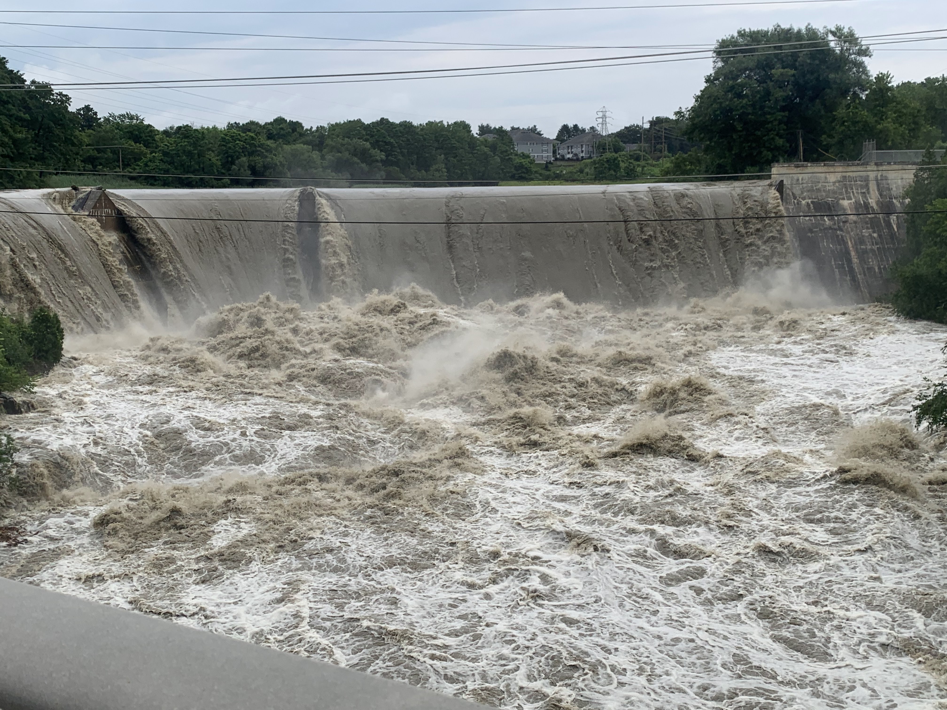 |
| The dam on the Winooski River in Essex Junction, Vermont on Tuesday. |
This morning, officials had also announced they would release water from two dams in southern Vermont, which would exponentially worsen flooding. It turns out, the will only release a little water, and additional flooding will be minimal.
THIS AND THAT
I'm so impressed by how heavy and widespread the rain was. All but one county in Vermont had at least one town with a minimum of four inches of rain.
Highest totals included 9.2 inches in Calais and 9.05 in Plymouth. Widespread 4 to 8 inch totals were reported along the whole length of the Green Mountains, from Massachusetts to Canada. Valleys on either side had a little less.
For the record, my place in St. Albans, Vermont had a comparatively modest 3.75 inches of rain from Sunday night to this morning. That's still about the amount that should fall in an entire July.
There's a huge pent up demand now from Vermonters wanting to help. Which is both expected and awesome. It was really too soon on Tuesday to figure out where to put people and what they should do. Expect to see more information on that starting tomorrow and increasing through the week.
We are Vermont Strong, so I know we'll all help out as best we can. Watch this space for volunteer opportunities.
It's best if you avoid Vermont's hardest hit areas for now, unless you are there with a specific job to help with recovery, or media trying to inform the public. Gawkers are like the rest of the disaster debris: They're in the way and have to be moved.
LOOKING AHEAD
The only couple of good things I see in the weather forecast is the chances of showers, thunderstorms and downpours are low through Wednesday. The chances are not zero, and a handful of places might get unlucky, but most of us will be fine.
Except for the heat and humidity. It's relentless. one sign of this is in Burlington's low temperatures. If it stays in the 60s, it's probably humid. It has not been below 65 in Burlington since June 30. Daytime highs will remain stubbornly in the low to mid 80s.
A very, very weak cold front might briefly knock the humidity down a peg Wednesday night, and we might actually get down to the low 60s. But that's about it for relief.
 |
| Flooding in Richmond, Vermont Tuesday. |
The humidity will surge back in Thursday and stay with us for an extended period. Probably through much of next week.
Humidity means the risk of more heavy downpours. Which we need about as much as a submarine needs a screen door.
The best chances of heavy downpours are Thursday afternoon into Friday.
I know emergency officials and people from Governor Phil Scott on down have been emphasizing the danger from renewed downpours. And they're right.
A hint of optimism is these downpours won't be as horrible as what we just went through. They also won't be as widespread as they were Sunday night through Tuesday morning.
But even in the best of times, without us being completely waterlogged like we are now, these expected downpours would be capable of generating local flash floods.
With the ground saturated and roads, river beds and landscape left unstable by the floods early this week, the effects of any local downpours late this week would be magnified.
Shower chances last into next week, but it's too soon to figure out how light or heavy those might be.
A slight change in the weather pattern might - and I emphasize might - make us slightly cooler and slightly drier during the third week of July.
I don't know for sure that will come to pass. But a man can dream, right?
No comments:
Post a Comment