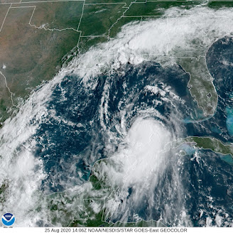
Now-Hurricane Laura finally got away from land masses overnight and is now in the open waters of the Gulf of Mexico.
 |
| Visible satellite shot of Hurricane Laura has the look of a new, and strengthening and dangerous storm |
Without land to disrupt its circulation, satellite images of Laura have "that look," by which I mean the appearance I've seen tropical storms have right before they explode into a major hurricane.
That's the fear right now. As soon to be Hurricane Laura takes aim at the upper Texas coast, it has a very good chance of becoming a major Category 3 hurricane, with winds over 115 mph and destructive storm surges.
It's very hard to predict future hurricane strength, but there are signs Laura could become an even more dangerous Category 4.
Worse, at least so far, is that various predictions keep nudging projected landfall Wednesday night further and further west, closer and closer to Houston.
The greater Houston metropolitan area has close to 7 million residents. To some extent, Houston is still reeling from the extreme Hurricane Harvey floods that devastated the city in 2017.
Nobody needs a major hurricane, and Houston in particular does not.
That's not to say Houston is guaranteed to take the worst of it. So far at least, the projected path would be far enough east to spare Houston the worst, but we don't know that for sure. Everybody in that area should be preparing for a major hurricane right now, and hope it hits a little further up the coast toward Louisiana, which has a much lower population density.
That's not to say I want people near the border of Louisiana to suffer. And it's not like nobody lives there. For instance, Beaumont, Texas, population about 118,000 could take a direct hit. It's just that avoiding a major hurricane landfall with Laura is now probably a lost cause, so you need to hope for the least bad options
People along the upper Texas coast, especially in low lying areas near the beaches, should be getting out of Dodge now before the weather starts to deteriorate during the day Wednesday. The storm surge from Laura looks like it will be especially nasty. That's especially true for any coastal area just to the east of where Laura makes landfall, because the winds would really shove the water onshore .
STORMS IN NORTHERN UNITED STATES
While not nearly as dire as a major hurricane, the northern United States roughly from Minnesota to Maine and down as far south as the Mid-Atlantic States have been dealing with rounds of severe thunderstorms. That state of affairs looks to continue through Thursday in at least some places.
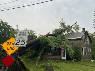
Yesterday, here in Vermont and surrounding places, there were pockets of severe storms. The worst of it hit around Whitehall, New York, just over the border from Rutland County, Vermont.
 |
| Storm damage in Whitehall, NY Monday |
There, rounds of severe storms - one after the other - produced damaging winds and extensive flash flooding around Whitehall. About 20 buildings suffered at least some flooding and some homes in town were damaged by falling trees.
As the storms pushed east into Vermont, that flooding extended into the neighboring towns of Poultney and Fair Haven, Vermont, where several streets and roads were blocked by high water and washouts.
Elsewhere, quarter sized hail cracked windshields and strong winds blew down trees around Lincoln and Buels Gore, Vermont. Another strong storm tossed down trees in Grand Isle.
Today that strong cold front we've been talking about will come through, but too early in the day to produce much severe weather in northern Vermont. The more you head south and east, the greater the chances of damaging winds from storms today.
The best chances of severe storms today run from around Washington DC up through New Jersey and into southern and possibly central New England.
The western half of the cold front that's coming through here today will stall from the eastern Great Lakes to the Mid-Atlantic states, prompting a severe weather threat from northern Michigan and down through western New York and Pennsylvania. None of this will affect us here in Vermont.
On Thursday, a wide band of severe weather potential runs from South Dakota all the way to southern New England and the Mid Atlantic States. Southern Vermont might get into the act, depending upon how far north a warm front manages to come.
So yes, that's rough and tumble, but nothing like Texas and Louisiana are about to go through with Laura Months ago, they warned us that this would be an active and possibly destructive hurricane season, and it looks like those predictions are coming true.

No comments:
Post a Comment