
 |
| Here's something you don't see everyday. A low, but definitely not zero chance of a tornado or two in this region today. |
If things come together just so, there could be some severe storms later today, especially in northern New York and perhaps western Vermont. Then there's Tropical Storm Isaias.
First the storms. I warm front blew through Vermont this morning with some no-big-deal showers. The question is, what happens this afternoon?
Some of the ingredients will come together for severe storms: These include unstable air ahead of a cold front, along with strong winds aloft which could produce clusters of strong storms or even a few rotating supercells.
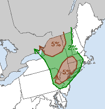
That's why NOAA's Storm Prediction Center has a low, but not zero chance of a tornado or two across the northern New York and the Champlain Valley of Vermont. The forecasters think that's the most likely location of a couple of supercells, of all things.
Already, early this morning, a cluster of storms in eastern Pennsylvania had already started rotating a little bit, and there is some risk that a tornado could spin out of this as it heads toward the Northeast.
Arguing against severe weather is the possibility there won't be much sunshine in our neck of the woods this afternoon. Sun is crucial, as it would heat the surface, increasing the contrast in temperature between down here on the ground and the temperatures several thousand feet overhead.
That would create stronger updrafts in storms, and thus, stronger overall storms. The key will be how much sun breaks through the clouds after the warm front gets up into southern Quebec. It seems like there's going to be a lot of cloud cover left over after the warm front blows by. That would limit the potential for scary storms.
In Vermont, the storms probably won't get here until evening as the sun is setting. That would be a start of a weakening trend in any storms, which is good.
For right now, the National Weather Service in South Burlington is going with scattered hit and miss storms this evening, and maybe a couple could be severe.
TROPICAL STORM ISAIAS
Tropical Storm Isaias is struggling along the east coast of Florida. It keeps firing off the intense thunder storms needed to maintain a tropical storm, but strong upper level winds keep ripping those storms away from Isaias' center.
So, it's down to tropical storm. It still is creating or will create dangerous wind gusts, even more dangerous storm surges and heavy rain in some parts of the Southeast.
Isaias is still likely to head up the coast, and probably take a slightly inland track. That minimizes the chances of destructive winds, but there will still be quite a bit of rain along its path.
At this point, at least, it still looks like the heaviest rain would hit the southeastern half of Vermont. There could be one to three inches of rain with this in those areas. Which is actually a good thing, since it's been so dry.
Northwestern Vermont will get some rain, but probably not the decent downpours we truly need.
One wild card is the possibility of that predecessor rain event, or PRE, that could take shape somewhere in the Northeast late Monday and Tuesday. A PRE is an area of very heavy rain that forms well to the north of a northbound tropical storm or hurricane.
They're hard to predict, and especially tricky to establish in advance where they might set up. So it's possible somebody in our region might get a round of heavy rain sometime late Monday or Tuesday in advance of Isaias, which would come through New England later on Tuesday.
No comments:
Post a Comment