Showing posts with label Isaias. Show all posts

Tuesday, August 4, 2020

Isaias Now A Big, Dangerous Threat To Vermont, Northeast

UPDATE 3 PM   
The area depicted in the pink cloud
like feature in this map is an area
most at risk for flash flooding this
afternoon and evening from Isaias.

We're now just beginning to get into the thick of it in Vermont now with Tropical Storm Isaias.

Heavier rain bands are starting to move northward across the state.  Rotating storms are starting to appear in far southern Vermont.  As of 2:35 p.m., there was a tornado warning just north of the Massachusetts border for areas around Jacksonville and Wilmington, Vermont.  The warning has since expired.

Other potential spin ups are possible in southern Vermont. 

I'm starting to think that the track of Isaias will move even slightly further west than we thought this morning. Perhaps up the western shore of Lake Champlain? I'll want to keep watching that. 

If this slightly more western track happens, there would still be a real flash flood threat , especially over western Vermont.  But it would increase the danger of flash floods in eastern New York.  Remember, the heaviest rain usually falls along and west of at tropical storm's track through the Northeast.

NOAA in a flash flood "Mesoscale Precipitation Discussion just issued around 3 p.m. said flash flooding is likely in most of Vermont and eastern New York over the next several hours.  Highest risk areas are in mountainous terrain like the Catskills and Adirondacks of New York and the entire Green Mountain chain in Vermont, along with urban areas like Albany, New York.  I'd add places like Burlington, Rutland and St. Albans as at risk areas for urban flooding.  

Earlier this week, I was looking forward to perhaps a beneficial inch or so of rain in Vermont from Isaias. Instead, we're in for too much too fast.  I still don't think this will be as bad as Irene, but I DEFINITELY think we should take the flash flood threat very seriously. 

The most torrential rains will ramp up starting in far southern Vermont any moment now and work northward.  There area also already some pretty heavy rain bands in central Vermont, too. 

Again, the heaviest rain will be in western Vermont, but all of the state is at risk of heavy enough rain rates to create local flash floods, road washouts and culvert collapses. This situation should go on until, I'd say, about midnight. 

A slightly more western track could open up a little bigger chunk of eastern and southern Vermont into a tornado threat zone. The threat is low, but by all means NOT zero.   It's also going to be hard for any tornado warnings to go out.  This type of tropical storm creates situations in which rotation spins up really fast, even before any forecaster can eye trends and see the rotation starting.

By the time the tornado warning goes out, chances are the rotation, or even a tornado, has come and gone. 

There is a tornado watch in effect for far southern Vermont. What really blows my mind is that this is the second time in three days parts of Vermont have been under a tornado watch, and it's the third time that's happened this year. 

So far, there have been no confirmed tornadoes in Vermont this year.  Let's keep that record going!

We're still looking at strong winds in many areas as this develops into the evening. All of Vermont can expect some gusty winds early tonight, and possibly overnight. The strongest winds still look like they will be over eastern Vermont and the western slopes of the Green Mountains.

Be prepared for scattered power failures as winds ramp up to 55 mph gusts in a few spots. The strongest winds will come after the heaviest rain has arrived and the winds will taper off after the heaviest rain ends, as it looks now. 

I'd continue my advice to stay home this evening, unless you're in a flood prone area.  Keep an ear out for any new warnings that might be issued, be there for strong winds, flash flooding, or even, possibly, a tornado warning or two. 

PREVIOUS DISCUSSION

Tropical Storm Isaias continues to be impressive and a big threat to the Northeast including Vermont. 

It's time for a deeper dive into this storm, since it's now on its way into the state this afternoon and evening.   
Heavy rains are coming with Tropical
Storm Isaias. Two to five inches
 of rain could easily cause flash flooding.

As of 11 a.m., Tropical Storm Iasais was over Maryland, and the forecast calls for it to be about over Albany, New York this evening, then go right up the Champlain Valley to a position near Montreal by early Wednesday morning. 

That's an odd track for a tropical storm, but whatever. This year has been supremely weird so nothing surprises me any more. 

Isaias was causing all kinds of problems along the East Coast today, as you'd expect. Like most tropical storms that move northward up the coast, the heaviest rain tends to be along and just west of the path. Highest winds are usually along and just east of the path. 

Tornadoes are often possible with tropical storms and Isaias seems to be good at producing tornadoes.  I think this is mostly because Isaias is an "inland runner," as opposed to most tropical systems that go over or just off the East Coast. 

Isaias' path puts heavily populated areas of the Northeast under threat of high winds, severe thunderstorms and tornadoes.  As it moves north, the tornado threat will increase over much of New England.

There's only a very low chance that any particular spot would be hit by a twister, but I'm just saying those are a possibility. This includes southeastern Vermont.  It actually looks like NOAA's Severe Storms Center will issue a tornado watch any minute for southern and central New England, including far southern Vermont. 

Because of mountains and terrain, it's hard to pick out rotation in storms via radar in southeastern Vermont, so a brief spinup could really come as a complete surprise to a handful of people down there. 

Already, a rotating storm did produce a brief tornado warning early this morning near Brattleboro

However, the principal threats from Isaias in Vermont is wind and flash flooding. The forward speed of Isaias is a little faster than expected, so it has slightly less time to weaken before reaching Vermont. More importantly, its track further west than we thought at this time yesterday puts most of Vermont at a wind and flash flood risk.  
Shaded areas on this map, especially zones
in pink and red, are at risk for flash
flooding from Isaias.

The rain will be heavier with this path, especially in the western half of Vermont.  Yes, it's been dry, so I"m still not expecting another Irene. 

However, this is important: Rainfall rates will be intense this evening, notably across the western half of Vermont and eastern New York.  The storm isn't even here yet and there have already been bursts of heavy rain

Urban flooding and dangerous flash flooding is likely, especially in hilly terrain. Watch out for road washouts, and be prepared to move to higher ground if floods threaten. 

For gawd's sake don't drive through flooded roads. You could easily either stall out, or the road beneath could be washed away. 

With Isaias now apparently going to target Vermont directly, expect higher winds,  All of Vermont is now under a wind advisory, with gusts in some areas of 55 mph likely.  The strongest winds are likely in southeastern Vermont and along the eastern slopes of the Green Mountains. 

We sometimes get winds of this strength in the winter, and those tend to only cause minor damage. But here's the difference:

Leaves are on the trees. It's summer, after all. Each leave acts like a little sail in the wind. These thousands of little "sails" on each tree will tug branches and tree trunks much further sideways than if the trees were leafless.

That increases the chance that some branches and trees will break, taking power lines down with them. 
Winds could easily gust to 50 mph in eastern Vermont and along the western slopes of the Green Mountains. Scattered power outages are a good bet. 
Shaded areas are at 
risk of a few tornadoes
from Isaias today. 
Highest risk in
yellow, lower risk
in brown, lower yet
in green.

One thing I've noticed with rare Vermont tropical storms is that as the storm passes through and as it begins to depart, strong north winds develop in the Champlain Valley. I noticed that during Tropical Storm Irene in 2011.  Most of Vermont had devastating floods but really not that much wind.  The Champlain Valley though, experienced strong winds and tree damage. 

Forecasters are looking at that possibility later tonight. 

So here's what to do:

1. Charge up your devices now, in case the power goes out.  It would't hurt to charge up the flashlights and LED candles, too.  No real candles, please. It's a fire hazard.

2. If you haven't already done so, get your lawn furniture and other stuff that can blow around inside, RIGHT NOW. 

3. Stay home later this afternoon and tonight.  We should be used to that, with our self-quarantining we've done for months over the coronavirus. 

4. If you must go out, don't drive through flooded areas.  Be very careful driving at night. It's really hard to see washouts and flash floods ahead of you until it's too late to stop the car.

5. Listen to trusted sources for the latest updates and warnings.  The National Weather Service office in South Burlington is superb.  All the local TV stations in Vermont have excellent, talented meteorologists, so we're blessed there. The Eye in the Sky people in St. Johnsbury are top rate also.

Don't bother with a lot of those apps you can get for phones. They're terrible. Also, have more than one way to get weather warnings.   For instance, if the power is out, you won't get warnings from the TV.  But if you also have a battery operated weather radio, you're still good. 

6.  I've said this before and I will say it over and over again.  Do NOT whine when a weather warning for a town dozens of miles away interrupts your viewing of the season finale of "Real Housewives of Enosburg Falls" or whatever you're watching.  

The TV stations don't have the ability to tailor warnings to just the few people that are affected by the warning. Be glad the TV meteorologists are warning people of danger, and know they will do the same for you if you're threatened by a storm. 

7. Sit back and enjoy the storm.  There's something sublime about listening to a downpour roar on the roof on a humid summer night. 

By the way, this storm will be out of our hair quickly on Wednesday morning. From there, we'll have a long period of tranquil weather. 


Sunday, August 2, 2020

Iffy Storm Threat Today; Isaias Questions Remain

Forecasters are facing some challenging forecasts for the next few days in and near Vermont.  
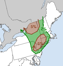
Here's something you don't see
everyday. A low, but definitely not
zero chance of a tornado or 
two in this region today.

If things come together just so, there could be some severe storms later today, especially in northern New York and perhaps western Vermont. Then there's Tropical Storm Isaias.

First the storms. I warm front blew through Vermont this morning with some no-big-deal showers. The question is, what happens this afternoon?

Some of the ingredients will come together for severe storms:  These include unstable air ahead of a cold front, along with strong winds aloft which could produce clusters of strong storms or even a few rotating supercells.

That's why NOAA's Storm Prediction Center has a  low, but not zero chance of a tornado or two across the northern New York and the Champlain Valley of Vermont.  The forecasters think that's the most likely location of a couple of supercells, of all things.    

Already, early this morning, a cluster of storms in eastern Pennsylvania had already started rotating a little bit, and there is some risk that a tornado could spin out of this as it heads toward the Northeast.

Arguing against severe weather is the possibility there won't be much sunshine in our neck of the woods this afternoon. Sun is crucial, as it would heat the surface, increasing the contrast in temperature between down here on the ground and the temperatures several thousand feet overhead.

That would create stronger updrafts in storms, and thus, stronger overall storms.  The key will be how much sun breaks through the clouds after the warm front gets up into southern Quebec. It seems like there's going to be a lot of cloud cover left over after the warm front blows by. That would limit the potential for scary storms.

In Vermont, the storms probably won't get here until evening as the sun is setting. That would be a start of a weakening trend in any storms, which is good. 

For right now, the National Weather Service in South Burlington is going with scattered hit and miss storms this evening, and maybe a couple could be severe. 

TROPICAL STORM ISAIAS

Tropical Storm Isaias is struggling along the east coast of Florida.  It keeps firing off the intense thunder storms needed to maintain a tropical storm, but strong upper level winds keep ripping those storms away from Isaias' center.  

So, it's down to tropical storm.  It still is creating or will create dangerous wind gusts, even more dangerous storm surges and heavy rain in some parts of the Southeast. 

Isaias is still likely to head up the coast, and probably take a slightly inland track.  That minimizes the chances of destructive winds, but there will still be quite a bit of rain along its path. 

At this point, at least, it still looks like the heaviest rain would hit the southeastern half of Vermont. There could be one to three inches of rain with this in those areas. Which is actually a good thing, since it's been so dry. 

Northwestern Vermont will get some rain, but probably not the decent downpours we truly need.

One wild card is the possibility of that predecessor rain event, or PRE,  that could take shape somewhere in the Northeast late Monday and Tuesday. A PRE is an area of very heavy rain that forms well to the north of a northbound tropical storm or hurricane.

They're hard to predict, and especially tricky to establish in advance where they might set up. So it's possible somebody in our region might get a round of heavy rain sometime late Monday or Tuesday in advance of Isaias, which would come through New England later on Tuesday.

Friday, July 31, 2020

Hurricane Isaias Now A Threat To U.S. East Coast

Now-Hurricane Isaias is yet another over performer, taking advantage of the jet fuel warmth of this
Hurricane Isaias is looking a little 
disorganized this morning due to 
strong upper level winds interfering
with it. 
year's tropical Atlantic Ocean waters to intensify.

This, despite a tussle with the mountains of the Dominican Republic, which should have at least kept Isaias somewhat in check. 

But as the mountains there tried to disrupt the system, a new center seemed to form just north of that island and away we went. 

At last check Isaias was packing winds of 80 mph and will probably keep strengthening as it hits the Bahamas today.  Not good, since the northern Bahamas were trashed by Category 5 Hurricane Dorian last year, so another blow from a hurricane is not needed.

The future track and intensity of Isaias is still a little questionable, as it is for all tropical systems. But the hurricane is a United States threat from Florida all the way to Maine and possibly beyond. As of this morning, Isaias was waging a battle with some strongish upper level winds, which were messing with its organization and ability to strengthen rapidly. 

The water ahead of Isaias is super warm, though, so that should help the storm at least maintain itself, if not get more powerful.

Once Isaias reached a point near the East Coast and starts moving northward, a couple dozen miles either way east or west in its track can make a big difference. Isaias is now expected to take a track parallel or even possibly over the Eastern Seaboard.  If it stays well offshore, that's a good thing. Then it won't be too bad.  Close or over the coastline, then you have a real problem. 

If it makes landfall anywhere between Florida and North Carolina south, it will be a HUGE mess for those regions between now and Tuesday or so.  Or, Isaias could stay just off the coast until it crashes into Long Island mid week or so, causing havoc there and in eastern New England.  Or it could stay off the coast and give just a glancing blow.

All of those potential scenarios are on the table right now. 

Intensity is a question too.  The waters along the entire East Coast are much warmer than average. Hurricanes tend to weaken as they approach the Northeast because of chillier water up there.  But this year's bathwater would tend to slow that weakening trend with Isaias. 

If Isaias makes a solid landfall in North Carolina or points south, the main threat in the Northeast would not be really be wind but torrential rains instead. 

 If it goes directly at Long Island or New England,  that neck of the woods could have a full-fledged hurricane, perhaps similar to Hurricane Bob in 1991 which actually made landfall in southeastern Massachusetts that year as a Category 2 hurricane with top winds of 100 mph with higher gusts. That storm caused $680 million in damage in New England.  

The best case scenario would have Isaias make a good right turn and stay off the coast altogether.

Even before Isaias gets near the Northeast, if it does, something called a Predecessor Rain Event or PRE's that can occur ahead of a hurricane or tropical storm along the East Coast. 

This is an area of very heavy rain that sets up well north or northwest of a tropical storm moving up from the south.  They are often located 500 miles or more north of the actual storm. They can cause tremendous flooding and definitely should be taken seriously. 

PRE's are hard to forecast. They're especially hard to figure out where they will set up.  On Sunday, some type of storm will head northeastward out of the Ohio Valley toward the eastern Great Lakes. It's possible the combination of this and Isaias could set up a PRE, although we don't know yet if that will happen, or if it does, exactly where.  

It just means there's potential for trouble even for locations away from the coastline.  

Florida is a real concern if Isaias hits there.  If any evacuations or damage occurs, it will be more complicated this time in Florida than it was with Dorian. 

Already, the state has decided to close coronavirus testing centers due to the threat from the hurricane.  That will affect the level of care people get, and assessments of how its spreading. The Florida state government has already done an abysmal job with this pandemic, and this will only make things worse. 

As I already noted, Isaias is a threat to a very big and very populated East Coast, so this could be a nightmare of evacuations, damage and fear mixed in with the coronavirus. They'd said we might be in for a bad hurricane season this year, which is never a good thing.  The timing this year with the pandemic could not have been worse.

Let's hope the computer models that keep it further off the coast are correct. But of course it's too early to know that yet. 

VERMONT EFFECTS

We have no good idea yet how, or even if, Isaias will affect Vermont. At this point, at least, it's looking more like a 1991 Hurricane Bob than a horrible 2011 Irene, but we still have to be alert, as that could change. 

Vermont escaped the worst of Hurricane Bob. All we got was a day of rather heavy rain and gusty, but not super damaging winds in southeastern Vermont and light rain in the northwest.  Of course we all know what Hurricane Irene did to us. 

Forecasters don't yet have a good handle on what kind of effects Isaias would have on Vermont.  Unlike the wet summer leading up to Irene in 2011,  most of Vermont is abnormally dry or even in a drought, so there's more capacity to soak up heavy rains than there was in 2011.

Of course, the heaviest rains fall to the northwest of a hurricane or tropical storm track, so it's possible we could have some flooding.  Especially if we are unlucky enough to fall under one of those PRE's I mentioned above. 

As you've seen and heard me say several times, just stay tuned on this one.  Before we even get to the middle of next week, we have Sunday's inclement weather to deal with. 

Early indications are the most rain Sunday will fall to our west.  Also, if a warm front moves far enough north on Sunday, there could be a severe storm or two. Before that, things will be benign, with just a low chance of a shower or garden variety thunderstorm this afternoon.