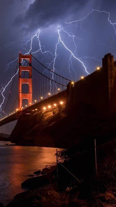
Two days of rare northern and coastal California lightning have sparked a bunch of new wildfires as a record heat wave rolls on.
It's certainly rough going out there this week.
The thunderstorms only produced a little rain, but created lots of lightning strikes. The vegetation is bone dry, so even the bits of rain that came with the storms failed to prevent fires.
Summer lightning storms like this are extremely rare in the San Francisco Bay area and Napa Valley, so this is another example of weather off the rails.
As the Los Angeles Times reported: "'Wild night in the San Francisco Bay Area. This is probably the most widespread and violent summer thunderstorm event in memory for the Bay Area, & it's also one of the hottest nights in years,' tweeted Daniel Swain, climate scientist with UCLA and the National Center for Atmospheric Research."
These types of thunderstorms are rare in California because the air is dry over land. The nearby ocean water is cool, which stabilizes the atmosphere. But moisture from a dying tropical storm made it northward all the way to the Bay Area. The heat wave added to the unstable air mass, and thunderstorms blossomed.
Water temperatures along the coast of California are still cool, but warmer than normal, so that might have contributed as well.
By 4:30 a.m, Sunday, firefighters were at seven brush fires in the Bay Area caused by lightning, the L.A. Times reported. More storms and dry lightning hit on Monday. A video compilation of the lightning is at the bottom of this post. It's pretty cool.
This comes in the middle of a strong, long heat wave. Records highs have been set all up and down the West Coast in recent days. After what might be a world heat record of 130 degrees Sunday in Furnace Creek, California, the town had a chillier day Monday as the high only reached 127 degrees.
Today, heat warnings and advisories are up for a huge area of the West from central and southern California, Arizona all the way up to Idaho and Montana.
Red flag warnings for high wildfire risks cover most of these same areas.
TROPICS HEATING UP
Right on cue, the Atlantic tropical storm machine is cranking up right about now, as forecasters have been telling us they would at this time.
Last week we had tropical storms Josephine and Kirk, both of which were really nothing burgers that didn't affect anybody on land to any extent.
Right now, though, there are two storms brewing that seem to to warrant being put on the watch list.
The first is a disturbance just about to head westward into the Caribbean Sea. Its forward motion is so quick that the disturbance can't get its act together, so it's unimpressive now. The National Hurricane Center thinks this batch of showers will slow down and encounter better conditions to develop into something more serious in the western Caribbean in a few days.
Further to the east out in the open Atlantic, an impressive cluster of storms moved off the coast of Africa a few days ago. This patch of storms is getting more organized, and a tropical storm should form out of this within a few days.
It's way to early to know how, or even if, either of these wannabe storms will affect the United States or other populated areas. However, both do show signs that they could hit land eventually. The National Hurricane Center is certainly monitoring all this. The two wannabe storms will probably be featured in future posts of this here blog thingy.
Video:
Different views of the California lightning:


No comments:
Post a Comment