Showing posts with label predictions. Show all posts

Tuesday, February 24, 2026

Are Pennsylvania Ice Jams A Glimpse Of Vermont's Early Spring Future?

An ice jam in Swanton, Vermont after a rainy, warm
January thaw in 2018. This will be the first early
spring in a few years in which ice jams are
a real concern However, there's no
evidence that there's anything imminent. 
 Rain and a spring thaw in parts of Pennsylvania last week caused several potential dangerous ice jams.

Luckily, the Pennsylvania jams either broke up fast enough to prevent serious damage or hit in rural areas where there was little to damage. But those jams last week prompted some flash floods warnings and evacuations. 

It was a reminder, though, that a winter with lots of cold and snow can really create trouble when the spring thaw arrives in earnest. 

The same thing could happen here in Vermont later this spring. 

After a bitterly cold late January and early February. the weather abruptly turned in western Pennsylvania last Thursday and Friday. Thunderstorms dumped bursts of heavy rain on that region last night. By noon Friday, Pittsburgh's temperature was up to 63 degrees. 

That kind of late winter weather is a recipe for ice jams. Thick ice on rivers broke up in that weather, and the chunks of ice got stuck on river beds, bridge abutments and other obstacles. 

 It has temporarily gotten colder in Pennsylvania, so the risk of ice jam floods has eased. But if there are still frozen waterways there or anywhere else, there's a risk of ice jam floods as we head toward spring.

"Anywhere else" includes here in Vermont.

Pennsylvania's experience makes me wonder what might happen in Vermont later this spring. Ice on the rivers is thicker than it's been in years. There's a fair amount of snow on the ground ready to melt.

No real thaws or heavy rain is in the forecast. But a little more snow is in the pipeline. Thankfully no big storms, though. The later we get into March without a thaw, the more likely the weather could change abruptly to something warm and rainy. Which would set us up for ice jams. 

As prepped as Vermont seems for ice jam floods, we have a more than decent chance of avoiding trouble. In Vermont's history, we've had winters that were much colder, much snowier and much icier than this one. After most of those winters, the spring melt was gradual enough to only give us the usual minor spring lowland flooding. 

I'm only bringing this up because this is the first winter we've had in awhile in which river ice has gotten thick enough to build strong ice jams if the weather is right for them. 

To avoid trouble, we'll want perfect sugaring weather. That means mild, thawing afternoon and chilly subfreezing nights with only light precipitation. Under those conditions, the snow and ice softens and  gradually melt. . 

If we have a sudden, rainy warmup later in March, and the ice jams do develop, we can still be just fine.

Much like in Pennsylvania, our ice chunks under this fast thaw scenario would get hung up on river bends and other obstacles. The ice jam would then create flooding just upstream fro where the stuck ice is.  

Where these ice jams set up would spell the difference between slight inconveniences and real trouble. The unlikely but worst case scenario would be an ice jam just downstream from Montpelier. That would back the water up into the downtown, like it did so devastatingly in 1992.

Since Montpelier is to some extent recovering from the even worse July, 2023 flood, we don't need that. 

Bottom line: Don't panic, since there's absolutely no reason to. Instead just be aware if we have a spell of warm, rainy weather coming up over the next month.  

Saturday, August 9, 2025

Just Calm Down Already About Those Wild Hurricane Forecasts

Despite the hype, we'll go to the National Hurricane 
Center. There's a low chance (in yellow) a tropical
storm might form in the central Atlantic, and a
medium chance (orange) that a storm or huricane
will form further south 
 It's that hazy, crazy time of year when you see those wild hurricane forecasts for a week or two in the future. 

A powerful hurricane will hit Florida! Wait, there will be two giant hurricanes attacking Florida from either side!  Whoops! New England is about to get blasted by the worst hurricane since 1938!  Oh, we lose New Orleans and Houston again!

Of course, it's almost guaranteed we will not see any of the scenarios later this month.  But these forecasts are all over social media, even if they're accompanying by a disclaimer that they're not an actually forecast. (Duh!). 

It's all about clicks and revenue for whoever is posting, you see. 

The forecasts are grounded in just the faintest glimmer of reality. The computer models that meteorologists rely on spit out new scenarios every six hours or so. (Some more frequently).  I've seen all the above scenarios in recent model runs, all happening around August 20 or 21, give or take.

I've written before about these "phantom hurricanes" in computer models. Now that we're getting into peak hurricane season, we've also entered into peak phantom hurricane season.

Despite the fact that the hurricanes depicted a couple weeks down the road won't play out like that in reality, these model runs are still useful.

They're all consistently telling us that the Atlantic Ocean is about to get pretty active with tropical storms and possible hurricane activity.  The model runs are a shot across the bow, warning us to pay attention starting now. 

Nobody can tell you for sure if a hurricane will form, and if it does, where it will go, but something will probably form. If you live in a hurricane prone area, you should finish stocking up the supplied you'll need if you ever receive a hurricane warning 

The fact that we're suddenly seeing hurricanes in the long range forecast is right on schedule. Disturbances  start coming off of the west coast of Africa in the July or the first half of August. Some of those disturbances turn into hurricanes. 

One of them is now in the central Atlantic and has a low chance of turning into a tropical storm or hurricane. If it does, the National Hurricane Center broadly thinks it will head north and not hit land, but again, no promises.

Another disturbance just came off the African Coast and is in the eastern Atlantic. The National Hurricane Center is a little more bullish on this one, so far giving it a medium chance of developing into something. 

This is the one those computer models are depicting, the one that would destroy, Florida, New England, or hell, North Dakota for all I know. 

Again, nobody knows whether this thing will come anywhere near the United States, and if so where and at what strength. As you can see in the map of this post, the National Hurricane Center brings it west to northwestward, ending up somewhere in the tropical Atlantic in several days. The general area they think it might end up is the orange shaded area. 

From there, who knows?  Stay tuned

OVERALL SEASON

The National Hurricane Center this past week updated its forecast for the rest of the season. They're predicting 13 to 18 named storms, including the four tropical storms we've already had. An average season has 14 named storms, meaning tropical storms or hurricanes with sustained winds of at least 39 mph. 

The NHC expects five to nine hurricanes (winds of at least 74 mph) and two to five major hurricanes, with winds of 111 mph or greater. 

Those figures are slightly busier than an average season.

What matters most is where those storms go.  There's some indication the United States East Coast might be a little more vulnerable to hurricanes than usual this year. 

As the Washington Post explained on Thursday, a marine heat wave has developed in the western Atlantic Ocean and Gulf of Mexico. A marine heat wave is when an area of the ocean warms up dramatically to or near record levels. 

If a hurricane encounters those warm waters on the way to the United States, chances are they'll grow to be much stronger than a similar storm that encounters somewhat cooler water. In general, the hotter the water, the greater they chance a hurricane will grow stronger. 

Marine heat waves were a major reason why Hurricanes Helene and Milton proved so destructive when they hit the United States last year. 

Certain weather patterns steer hurricanes toward the East Coast and we seem to be trending toward ingredients that would do that. These include a strong Bermuda High with a westward extension toward the United States that would prevent a westward moving hurricane from the tropics from turning northward, out to sea.

Another ingredient is a strong blocking high pressure system over eastern Canada, which again would steer a hurricane up the coast rather than letting it curve eastward, out to sea

The third ingredient is a dip in the jet stream over the Appalachians. That dip might or might not develop in the coming weeks. But such a jet stream arrangement becomes a little more likely in September, which coincides with what is usually the worst of hurricane season. 

So, when you see those maps into the future on social media, the ones that tell you that your city will be wiped out by a major hurricane within two weeks, honestly just relax.

But don't ignore it. 


Thursday, January 2, 2025

Winter Hype Vs Reality: Yes It Will Get Cold, But No Storm Of The Century

On December 30, the American computer models
depicted an intense storm over the Northeast on
January 11. This won't happen, but this type of 
thing doesn't stop the people hyping extremes
on social media from highlighting it for clicks
and revenue. Then the update.......
With the forces of Arctic air gearing up for an invasion into the United States, the social media hype on the weather corners of social media are gearing up for maximum clicks and hoped-for revenue.  

You know the drill

Worst Cold Wave Ever, Millions Will Die Of Hypothermia!!

Entire East Coast To Be Buried In Worst Blizzard Ever!

Huge Florida Snowstorm! Blizzard To Hit Cuba!!

OK, I'm exaggerating, the hype isn't quite that extreme, but you get the point.  

The social media weather weenie click addicts are taking advantage of an upcoming cold wave to really drum up the revenue efforts by telling you the End Of The World Is Nigh, and it's in the form of extreme winter weather. 

If you believe any of this crap, Me and Jackson the Weather Dog are here to calm you down.  The Storm Of The Century is not looming, so we can all take a chill pill.

The weather hype gang is cherry picking some of the more exciting computer model images. Every day, there are dozens and dozens of models and model runs forecasting what might happen a week or more down the road.

These long range models are useful in telling us overall trends. Will it be generally stormy or calm 10 days down the road? More than a week from now, will it be generally warm or generally cold? The long range models can help with those questions.  

What those models can't do is tell us specifically where a storm will be say, ten days from now, how intense it would be and what type of weather it would bring. 

The maps in this post illustrate how both the hype and reality work. 

This morning's American model for the same date as
above, January 11, shows benign weather over
New England. If this came true, we'd have a 
chilly northwest breeze and mountain snow showers.
It's too soon for either map on this page to fully,
accurately predict what will actually happen Jan. 11.

 For fun, I cherry picked one version of  the American model, issued December 30, which shows a super intense, probably destructive storm in the Northeast on January 11. 

If this came true, which it almost certainly won't, New England would face damaging winds, coastal flooding, inland flooding and deep, disruptive snow and ice inland. 

This is precisely the type of image the click bait people jump on. Stuff like this was all over social media. 

Then I took a look at one run of the latest American model, issued this morning, to see what they have planned for January 11. 

The answer? Not much. It shows a moderate, cold northwest wind over New England with some mountain snow showers and a nippy high pressure system approaching. 

Since January 11 is still more than a week away, we probably won't exactly have either of these scenarios, though the calmer version of the two is more likely.  This long range forecasts indicate it  will probably be cold, and a perhaps a bit unsettled on January 11, but it can't give us more details than that. 

What follows is the bottom line. 

Here's what we know:

 It's going to get cold here in Vermont, and in most of the eastern two-thirds of the nation sooner rather than later.  In most places, the cold won't be extreme for the middle of winter, but might intensify some once we get into the second week of the month. 

This won't be the tropical type winter month that we've seen too often in recent years. But it won't be the coldest ever. Not by a long shot. 

It's definitely going to snow in a lot of places, but for the most part it's too soon to say who will really get nailed with deep snow.  Places prone to lake affects snows near the Great Lakes are getting hammered, as you'd expect in this type of weather pattern.

It looks like some sort of storm will spread snow, ice and rain from Kansas to the Middle Atlantic States Sunday and Monday.  Exactly who gets the worst weather and how much they get is still TBA. It looks like it might end up being  a rather disruptive storm in those areas, but, hey, it's winter in the Grand Old U.S. of A.

Here's what we don't know: 

There will be other storms in the next couple weeks, and some places will get nasty amounts of snow, ice, schmutz, wind and cold.   But unlike some breathless things I've seen on YouTube and elsewhere, nobody's getting a repeat or worse of the Blizzard of 1993.

Computer models are also all over the place beyond a few days from now as to how intense the cold will get, where it will be at its worst and how long it will last.  True, the eastern  half of the nation will be nippy for sure..

But it remains to be seen whether this will be a run of the mill January wave or something worse. Winters have generally gotten milder, so even a moderately intense cold snap might feel pretty bad.

Here in Vermont, aside from persistent mountain snow showers, we seem safe from any big winter storms for awhile. The one I mentioned above for Sunday and Monday should pass by well to the south. 

Beyond about five days, it's virtually impossible to tell whether anything will come by to bring us substantial snow.  For what it's worth, the computer models aren't pretty much not showing anything dire for awhile, other than it'll be cold.  

Bottom line: The next time you see somebody tell you that a week from ten days from now, we will have some sort of dire, once in a lifetime weather event, ignore it, and move on. These people don't need the attention. 

The National Weather Service and your reputable local television meteorologists, or people like the Eye on the Sky folks in St. Johnsbury will have a much better handle on things. 

Tuesday, October 29, 2024

It's That Time Of Year For Winter Forecasts. Not That They'll Actually Come True, But......

NOAA is leaning toward a milder than normal winter
in the South and East. Here in Vermont, I doubt
it will be as toasty as last winter, which was
the warmest on record. 
 Every year, countless people and organizations try to read the tea leaves to tell us in advance what kind of winter we'll have.  

The forecasts are very often wrong, but whatever. I guess it's fun to try.

For a change, there's one certainty in the winter forecast for Vermont that we haven't seen in other years: I almost guarantee this winter will be colder than last. 

That's because last winter was the warmest on record, and in much of the Champlain Valley, it never even got below zero last go around. 

But will it be just a tiny bit cooler than last winter, but still warm? Or will the bottom drop out of the thermometers in December, January and February?

Dunno, since long range forecasts are often super unrelaible.

But let's see what the pundits have to say.

NOAA/NATIONAL WEATHER SERVICE 

NOAA is forecasting a La Nina winter, which is a cold phase for water in the eastern Pacific Ocean that influences much of the weather around the world.

That means says NOAA, that chances in general favor warmer than average temperatures in the southern and eastern United States and with colder than average weather in the Northwest.

Precipitation under NOAA's scenario would be on the light side across the southern United States and leaning perhaps above normal in the Pacific Northwest and near the Great Lakes.

For us in Vermont, NOAA is leaning toward warmer than normal, but not as strongly as they are for the southern United States. As for whether it will be wetter or drier than average, NOAA says it's a tossup for us, maybe leaning sort of toward the wet side.

Of course, the other question is whether that precipitation would be mostly in the form of rain or snow. La Nina winters slightly favor above normal snowfall in northern New England, ,so we shall see.

Last year, NOAA predicted we'd have a warm winter and they were right. They'd said that winter precipitation would be a tossup and it kind of was. December was very wet, January was sort of wet and February was dry.  A mixed bag there.

THE OLD FARMERS ALMANAC

This publication is not going for the wild winter weather it so often predicts. Says the Almanac: 

"'This winter, temperatures will be up and snowfall down through most of the United States, reports Carol Conner, the Almanac's editor-in-chief. 'While there will still be plenty of chilly temperatures and snow for most slopes, the high heating costs associated with the season shouldn't hit so hard. We're predicting a temperate, uneventful winter - potentially a welcome reprieve from the extremes of recent years.'" 

Unlike NOAA, The Old Farmer's Almanac has the South getting the bulk of the precipitation this winter. They expect the most snowfall relative to average in southern and central Appalachia, parts of the Ohio Valley and the Rockies.  

The Old Farmer's Almanac is calling for a winter that
will not be as dramatic as many recent winters.

The Old Farmer's Almanac map is kinda weird. It describes the upcoming winter here in New England and extending out to the northern Great Lakes and northern Plains as "mild, dry."

 But they have these odd little pockets of "cold, dry, stranding the Ohio/Pennsylvania border and in an area around souther Lake Michigan.

That doesn't really make meteorological sense, but whatever.  

Last year, the Old Farmer's Almanac was partly right for what happened in the winter 2023-24. They correctly said it would be mild, and it was certainly that. They also said it would be snowy, but snowfall was below normal last winter. 

THE FARMERS ALMANAC

Not to be confused with the Old Farmer's Almanac, about, this publication is just the Farmers Almanac. Sure, a little redundant maybe, but we'll deal. 

This outfit seems to be anticipating more drama than most of the other prognosticators. Most other forecasters limit the extent of persistent cold in the United States this winter, but the Farmers Almanac kind of goes for broke. 

They call for a cold winter in the Northwest and a vast part of the nation's middle, except the southern Plains. 

The Farmers Almanac predicts most of the South and East would generally be on the mild side, but with some intrusions of cold.

This group also is pushing a lot of storminess this winter.   The only place they anticipate lighter precipitation is in the southern Plains.

For us in Vermont, they have us somewhat on the mild side with very frequent bouts of rain and/or snow. 

THE WEATHER CHANNEL

The folks at the Weather Channel are pretty much in line with NOAA/The National Weather Service. They're predicting a warmer than average winter for pretty much the eastern and southern two thirds o the United States, including us up here in New England,

They're forecasting things to be on the chilly side in the northwestern part of the Lower 48.  It does seem the Weather Channel is a little more bullish on the eastern warmth than NOAA, We shall see! 

ACCUWEATHER

AccuWeather is in general agreement with most forecasters, predicting more or less warmer than usual conditions across the South and East.

They're focusing largely on snow, and are saying the heaviest snow, relative to average, would hit in the interior Pacific Northwest, northern Rockies, the western Great Lakes and northern New England. Their forecast of variable temperatures this winter, including thaws, means that ski slope snow might be icy or partly melted at times.

But that's pretty much par for the course in our neck of the woods. 

It it does prove to be an overall snowy in New England, AccuWeather is hinting that the bulk of it would hit late in the winter.

Last year, AccuWeather predicted a snowy winter in the Northeast. That didn't really come to pass.

THE BOTTOM LINE

Most forecasts agree with each other about what will happen with the weather this winter, and it's a bit unusual for almost everybody to be on the same page with these long range forecasts. By the way, I'm ignoring the click bait prognosticators on line who always predict ridiculous extremes to attract eyeballs and revenue, but don't actually know what they're doing. 

In any event, winter surprises are always possible. I'd say perhaps even likely.

And remember, even if the overall winter does turn out to be warm, that doesn't mean we won't have intense cold spells. For instance, the winter of 2022-23 was the fourth warmest on record. But we did have a quick spell of record cold in New England in the beginning of February that year. 

Whatever happens, winter will keep us Vermonters on our toes like it always does. 

My winter prediction is the same as it is every year. I'll let you know at the beginning of March, when it's pretty much over. Other than that, it's anybody's guess. And given what I've written above, anyone and everyone is indeed making guessing as to what winter will bring. 

 

Thursday, August 8, 2024

Some Cautious Optimism This Morning Regarding Debby, Flooding And Vermont

 I'll make one thing clear: 

Expected rainfall with Debby. One to two inches expected
in most of eastern Vermont, with two to four
inches northwest and mountains. Note that this is
a broad brush map. Locally higher amounts could
be embedded in some areas. 
There's definitely still a flood risk here in Vermont as we await the arrival of what will then be former Tropical Storm Debby.  Chances are more than decent there will be at least some damage around somewhere in Vermont. 

But - fingers and toes crossed big time - this is looking less like the wholesale new big disaster for Vermont than it did two or three days ago.

OVERALL TRENDS/NEWS

Forecast trends continue to keep remnant Debby zipping by and heading to Canada really quickly, which would limit the time the storm has to dump torrential downpours. And while those downpours are likely in at least part of Vermont, the biggest focus for them should be in the Adirondacks.

Not that I want that to happen. I'd  hate to see the kind of destruction in New York that we saw in Vermont earlier this summer.  But Vermont can sure live without another big flood, too. 

NOAA's Weather Prediction Center still has almost all of Vermont in a moderate risk zone for flooding with this. That's level 3 of 4 on the risk scale and definitely a sign of potential trouble. That said. it's possible that moderate risk in Vermont might be trimmed back later today in some areas if relatively happy forecast trends continue. We shall see! 

We're not completely out of the woods, of course. As mentioned, we're going to get some pretty stiff downpours. And there's still a few question marks regarding the exact track of what will be former Debby. 

For now, the National Weather Service in South Burlington is confident enough about heavy rain in the Adirondacks to issue a flood watch there.  No flood watch is in Vermont, at least not yet. There's some high resolution data that was just coming in early this morning they wisely want to take a look at first before making any decisions on whether to hoist any flood watches in the Green Mountain State. 

I notice flood-spooked Vermonters are taking no chances, which is a smart move. The city of Barre, repeatedly hit hard by recent floods, is making sandbags available for residents and businesses. 

Let's walk you through what meteorologists think will unfold as this thing goes by. As you're reading, remember, the forecast is subject to change. The paths of tropical storms and former tropical storms can be really unpredictable.

TODAY

Another nice one as the humidity remains low and bright sunshine bathes the state. At least for awhile. You'll notice increasing high cloudiness this afternoon, as what will be former Debby begins its charge toward us. 

It'll be a seasonably warm day with highs in the 77 to 83 degree range most valleys

TONIGHT

The burst of high humidity that tropical systems always bring along with them will ooze quickly in, turning the night from refreshing to muggy by morning. This blast of humidity will trigger a band of rain with a few embedded heavy downpours and thunderstorms. 

This won't be enough to trigger any flooding, but could prime the pump for flooding that might come with later bursts of downpours from Debby.

FRIDAY

It's going to be kind of a weird, tropical day. That band of initial rain will move out.  You'll notice the oppressive, awful humidity we had through most of July and the opening days of August will be back. Don't worry, this outbreak of air you can wear will be brief.

Especially on the Vermont side of Lake Champlain, there could be fairly long periods during the day with no rain at all. Or, there will be fitful, quick hitting showers that might not amount to all that much.

At first.

But especially if we see a fair number of breaks in the clouds, that could destabilize the air and trigger some torrential thunderstorms. We'll have to watch those for the risk of any isolated instances of afternoon and evening local flash floods. There won't be anything widespread, if anything at all, but it will be worth watching.

FRIDAY NIGHT

The heart of the storm, and when the greatest risk of flash flooding might happen. The steady, heavy rain should continue all night in the Adirondacks. Debby is actually using Vermont as sort of a meet up spot with a cold front coming in from the west.  

The two will team up to come through Vermont probably with a band of heavy downpours. (Latest projections from the National Hurricane Center has the center of former Tropical Storm Debby about over Morrisville at 2 a.m. Saturday)

The band of storms will be moving fairly fast, but since the rain will come down so hard, in many cases on already sopping wet soil, the risk of flash flooding goes up. Note that nighttime flash floods are dangerous, as they're hard to see and you might be sleeping when warnings go up. Have a way to wake up to warnings if you live in a flood-prone area.

 There's cautious optimism on main rivers like the Mad, Winooski and Lamoille, and the Otter Creek. All those waterways will have sharp rises, but so far, only minor flooding at worst is in the forecast. That could change if rainfall amounts and patterns change from what is now in the forecast, but for now, again, fingers crossed. 

There might also be a problem with wind in spots overnight Friday. Even though former Debby will be rather weak by the time it gets here, there will still be a fair amount of energy with it. Strong winds aloft could mix down to the surface overnight. That's especially true perhaps along the western slopes of the Green Mountains and maybe the Champlain Valley.

We won't have any ferocious windstorms like we did this past January, but gusty winds hitting trees on soggy, unstable soil could topple a few of them, causing some scattered power outages.

SATURDAY AND BEYOND

The remnants of Debbie should quickly scoot away, so most of the day should be rain-free. We'll need to watch how high main rivers get during the day, but as noted, I think we might be OK. We could really end up with a nice summer day on Saturday. 

Beyond that, a weak dip in the jet stream might promote scattered showers and rumbles of thunder, mixed with periods of sun Sunday through Tuesday. The showers will be light and widely scattered, and pose no flood threat. 


Saturday, February 10, 2024

Category 6 And Cones Of Uncertainty: Changes In Hurricane Forecasting Coming

With some hurricanes getting stronger under the influence
of climate change, should a new Category 6
be designated for the strongest ones?
 Category 5 hurricanes are probably the worst storm anybody could experience. 

These monsters have winds of at least 157 mph.  As the National Hurricane Center describes a Cat 5: 

"A high percentage of framed homes will be destroyed, with total roof failure and wall collapse. Fallen trees and power poles will isolate residential areas. Power outages will last for weeks to possibly months. Most of the area will be uninhabitable for weeks or months."

And that's not even talking about the monster storm surges with Category 5 hurricanes that can push tides to 20 feet higher than normal, with huge, battering waves.  

Gosh, if a Category 5 hurricane is that bad, what would a Category 6 do?

So far there's no such thing. Or is there such a thing?

Researchers suggest it might be time to create that category.

It's not close to hurricane season in the Atlantic Ocean yet. That starts June 1. But people spend all year thinking about these dangerous storms.  Which means changes could be in the works. 

So, the new hurricane category is bubbling out there. 

Category 1 through Category 4 hurricanes have a specific range of wind speeds. For example, category 3 hurricanes have winds of 111 to 129 mph.

Some hurricanes have been getting stronger in recent decades. That's all  thanks to climate change, which is making oceans and air temperatures warmer. That adds to atmospheric toasty water vapor, which is jet fuel for hurricanes. Especially when that water vapor is super warm. 

Cat 5s, have no upper wind range. Just 157 mph or more.  I would put the upper limit of Category 5 storms at about 175 mph.

Given the rising potential for stronger hurricanes, the question is should there be such a thing as a Category 6 hurricane?  We've already had a few hurricanes, or typhoons with sustained winds of 175 mph or more.

Typhoon Haiyan in 2013 had maximum sustained winds of 175 to 195 mph, depending on which meteorological agency was doing the measuring.

Hurricane Patricia had top sustained winds of about 210 mph off the west coast of Mexico in October, 2015. Patricia was a very weird hurricane, a very small in area storm that went from a nothing burger to extreme in a very short period of time, then rapidly weakening as it approach landfall. 

Hurricane Dorian in the Bahamas back in 2019 might also have qualified as a Category 6, with winds close to 200 mph. 

These type of super storms look like they're going to be more and more common with climate change. 

As Axios explains:

"(The study) also finds that human-caused climate change has more than doubled the res, of Category 6-strength storms since 1979, buy investigating shifts in metric called potential intensity."

I'm not going to get into the weeds on potential intensity, but the bottom line is some hurricanes are going to get a lot stronger than such storms used to be. 

The researchers suggest Category 6 hurricanes should have winds of at least 193 mph, but that figure is not cast in stone. 

While studies are ongoing, there's no word yet as to whether the World Meteorological Organization will sanction category 6 hurricane designations, or when that might happen 

CONE OF UNCERTAINTY

Another big focus is not so much on hurricane intensity but rather the prediction of those storms. 

A cone of uncertainty map for Hurricane Ian in 2022.
Changes are proposed for this type of map to help
the public better understand the dangers they face. 
Those who have ever seen hurricane forecasts have seen the "cone of uncertainty." That's the range of paths the center of a hurricane might take. 

For instance, a forecast might have a hurricane making landfall in say, Charleston, South Carolina.

 But at the point you see the prediction, the range of possibilities for landfall is as far south as Savannah, Georgia or as far north as Wilmington, North Carolina. That question are is known as the cone of uncertainty.   

It turns out, though, that this forecasting method can confuse or mislead some people in the possible path of danger. So the National Hurricane Center is coming up with a potential fix.

The Washington Post reports:

"The hurricane center will issue an experimental version this year that will depict watches and warnings for inland tropical storms and hurricanes, superimposed on top of the forecast cone, aiming to communicate not just the storm path but the extent of its potential impacts. 

It could prevent a repeat of Hurricane Ian, when many Floridians said the cone was a reason they underestimated the 2022 storm's widespread and severe effects."

 NHC always includes this disclaimer with a hurricanes cone of uncertainty: "Note: The cone contains the probable path of the storm center but does not show the size of the storm. Hazardous conditions can occur outside of this cone."

But as the Washington Post noted in an article not longer after Hurricane Ian in 2022:

"But the disclaimer is often stripped off versions of the cone displayed on television, and research has repeatedly shown that a minority of people understand what the cone does and does not depict.

Of 2,847 Floridians surveyed, almost half incorrectly believed that areas outside the cone were safe from hurricane damage."

Even if the cone of uncertainty turns out to be correct, damaging winds, destructive storm surges, and dangerous inland flooding routinely occurs outside that area. 

The new maps will depict the locations of hurricane and tropical storm warnings to better convey where the hazard risks are. A shortcoming to this is there isn't a good way to also include risks posed by storm surges and inland flooding without making the  cone of uncertainty maps confusing and too cluttered.

The National Hurricane Center does have separate graphics for storm surge and inland flood warnings. But that cone of uncertainty is what usually makes it on the evening news.  

Conveying the risks from hurricanes to the public will always be a challenge, but I'm glad people are trying to improve things the best they can. 


Wednesday, September 20, 2023

After Rough Summer, How Will Vermont Fall Foliage Fare?

A fungus brought on by Vermont's extremely wet, humid
summer afflicts these sugar maple leaves in Richmond,
Vermont. Though the fungus won't harm the trees, it 
could somewhat mute fall colors this year. 
UPDATE: I should have mentioned when I first wrote this post that people who visit Vermont this fall should have no trouble seeing the sights and the beauty and getting around. 

There's been questions from out of staters as to whether they can actually come up to Vermont, given the devastating floods we had in July.

The answer of course is a resounding yes.

The roads are back open, the vast majority of businesses that cater to tourists visiting Vermont were either undamaged by the flood or have re-opened. 

That's not to minimize the continued suffering and uncertainty for the thousands of people directly affected by the flood.

But visitors will see our usual beautiful landscape intact

PREVIOUS DISCUSSION

The first fall colors of the season are starting to pop up in Vermont, a little late, but still noticeable in just a few isolated pockets.    

The swamp maples have really started to turn red, and some of the more precarious sugar maples out there are showing some isolated pockets of  color.  Even so, it's still mostly green out there. Once again, it looks like fall foliage season in Vermont tis running a little late. 

So, will this season be a vibrant one, or a bust?

 First of all, predicting the timing and especially the vibrancy of fall colors is harder than forecasting the weather, so expect some misses on this issue.  

Maybe more importantly, you'll definitely find a lot of beauty this fall. It might or might not be as vibrant as the past couple of years, but it will still be stunning. 

The last two years brought perfect summer and early fall weather that led to brilliant foliage seasons. However,  I'm personally leaning toward a prediction of a somewhat more muted autumn show in 2023.  I suspect some of the more vibrant reds that really make the colors pop might be missing this year. 

As we well know, it was an incredibly rainy, incredibly humid summer, even if it wasn't exactly the hottest one in memory. All that moisture lingering everywhere encourages fungi and other issues on leaves.

I've noticed in many locations, many of the leaves on sugar maples are turning yellow with spots of black, and falling prematurely. That's a fungus caused in large part by the rainy summer weather. This ultimately won't hurt the health of the trees, but it could well mute the autumn show.  At least i some areas. 

Another wild card is the intense, record breaking freeze Vermont suffered on May 18.  The freeze destroyed new oak, sumac and ash leaves. They shriveled up, turned black and fell off. By the end of June, these trees put out a new set of leaves, but the foliage was thinner than we otherwise might expect. 

Most of the cold hardy leaves, like on maples, beech, poplar and such, but I don't know whether there was hidden damage that could affect fall color.  

The Vermont landscape still looks really green now that
we're into mid-September. Warm weather this summer
and September so far appears as if it might make 
for a somewhat late fall foliage season. 

There's another more permanent foliage disappointment starting now. The emerald ash borer long expected to go on attack against Vermont's numerous white ash trees, is really going on the attack  now. 

This summer, I saw big swaths of dead and dying ash trees, all victims of the emerald ash borer. Over the coming few years, this awful bug will decimate Vermont's ash trees, as it has in other states.

This is a big disappointment, of course. Ash trees add variety to the fall foliage pallete,  They punctuate the reds and oranges of hillsides with pops of gold and purple.   So their loss will be hard to take.  

On the bright side, another forest-wrecking bug, the spongy caterpillar, once known as gypsy moth caterpillars failed to make an appearance this year after a couple years of these little buggers defoliating big swaths of Vermont forest. 

Leaves usually grow back after the caterpillars leave for the season in mid to late summer, but the returning foliage tends not to be as thick or prone to great fall colors had the trees not been touched. 

This year, a short but intense Arctic outbreak in early February killed many of the overwintering caterpillar eggs. The humid summer encourage a fungus that kills the caterpillars. So I guess there was one small benefit to all that rain through June, July and August. 

In general, it's thought that a bright, dry September with chilly nights and mild days encourages a better fall foliage season. So far this month, the pattern has been mostly wrong for that. We had a midsummer style heat wave between September 3 and 8.  Nights have ranged from sort of on the warm side to downright muggy and toasty.

As of Tuesday, the temperature in Burlington had yet to fall below 50 degrees this month.  These warm conditions appear to be making fall foliage season late. As of this past weekend, many hillsides in Vermont looked as green as they do in July, with no hints of color yet. 

As climate change has made conditions warmer, there has been a general trend toward a later fall foliage season. I remember growing up as a kid that fall foliage season was largely over by October 10.  Now, most years, you can find good color in the warmer valleys during the third week of October. 

Two years ago, there was still pockets of pretty fall colors in the opening days of November. 

Temperatures have turned decidedly cooler over the past couple of days as we inevitably head deeper and deeper into autumn. 

Long range forecasts continue to call for generally above normal temperatures into early October, but above normal doesn't mean the same as it did a few weeks ago. Even these warm spells will feature chilly nights and shorter days that will encourage the leaves to turn color pretty fast between now and mid October. 

Video: Taken over the past few days, it shows fungus afflicting sugar maple leaves and causing them to drop prematurely.  It also includes a view of hillsides a few days ago around Richmond, Vermont still looking very green for mid-September. Click on this link to view, or if you see image below, click on that: 


Thursday, February 2, 2023

Quebec Groundhog Found Dead. What Does THAT Mean For The Rest Of Winter?

Fred la marmotte, seen here in 2018 was Quebec's 
answer to the groundhog Punxsutawney Phil. Fred
was found dead Thursday morning before he could
make his prediction, so what does that mean?
 Yes, yes, I know, the silly traditional Groundhog Day we had today is not scientific.

Supposedly, if the groundhog sees his shadow, we'll need to endure six more weeks of winter. The most famous one, Punxsutawney Phil in Pennsylvania, saw his shadow on Thursday, supposedly meaning spring is a far away dream. 

Never mind the output from meteorologists lately that suggest a possible early end to winter. I see NOAA's latest 8 to 14 day forecast, for what it's worth, predicts warmer than normal weather through mid-February.

Longer range forecasts also call for a warm February overall. NOAA also slightly favors a warmer than normal spring in the Northeast, too.

I don't entire trust these long range forecasts. A lot can go wrong. However, I'm quite sure the scientists at NOAA are much better at weather forecasting than some random rodent. Sorry Phil!

Which leads me to some tragic news from Quebec.  

The Canadian province's answer to Punxsutawney Phil, named Fred la marmotte, in Val-d'Espoir, Quebec, was found dead just before he was scheduled to come out of his burrow to predict how late winter would go. 

Perhaps Fred had heard that the Polar Vortex was about to settle into Quebec,  leading to an intense, but brief Arctic cold snap. 

But Yikes! What kind of prediction to you get when a groundhog is found dead? Sounds like the apocalypse. 

Death seems drastic, after all. Will the next six weeks be worse than just cold, or hazy, hot and humid, like summer?  Does this mean unprecedented storms?  Thirty feet of snow in a week? Something like the Great Quebec ice storm of 1998? Locusts? Noah's flood?

We don't know the cause of Fred's death, but it appears to be from natural causes. Maybe Fred was just depressed because his meteorological knowledge was not as great as, you know, real meteorologists.

Event organizers in Quebec figured Fred would have wanted a child to take his place if he had died  So a child was selected from the crowd on Thursday. For the record, that child, wearing a groundhog hat, predicted six more weeks of winter.

The kid was probably just hoping for more snow days that would close schools. So he could go to the sledding hill behind the school instead of hitting the books. 

For next year, we're told that Fred's son will take over the Groundhog Day leading role. It's a family business. Fred took over for his father several years ago when his dad died. 


Friday, October 21, 2022

Time For That Stupid "What Will This Winter Be Like" Parlor Game

Winter driving in St. Albans, Vermont a couple winters
 ago. It's virtually impossible to accurately predict 
what the upcoming winter will be like, but that's not going
to stop people from trying! 
 Right about now, it's peak frenzy time to predict what the upcoming winter weather will be like. 

I'm frankly not a big fan of this parlor game. There's so many factors that can influence the weather a couple, few months from now that it's almost not worth predicting. 

Besides, pretty much every winter here in Vermont is highly variable. Sure, some are cold, some are warm, some are snowy, some are rainy, whatever. But it's totally subjective. You might remember that horrible cold wave in January. Somebody else might remember a big February thaw.

The bottom line is, I'll tell you how the winter of 2022-23 will turn out. The catch is, I'll tell you in March, 2023. By then, we'll be out of winter and I can give an accurate accounting of it. 

For the record, the National Oceanic and Atmospheric Administration (NOAA) on Thursday came out with their prediction of what winter will be like for the United States.  

Their thinking is that chances are better than equal that it will be warmer than average across the southern tier of the United States, and up along the East Coast, east of the Appalachians. Chances are, according to NOAA, that it will be chillier than average from the Pacific Northwest, through the far northern Rockies into the northern Plains. 

NOAA is also suggesting it will be drier than normal across the southern tier of the United States, and perhaps wetter than normal in the Pacific Northwest, far northern Rockies and around the Great Lakes.

Everywhere else, it's a tossup.

If you look at NOAA's map, most of Vermont has an equal chance of being warmer or colder than normal, with a slight edge toward warmer than average in the southeastern part of the state. Also, most of Vermont has equal chances of being wetter or drier than average, with a slight edge toward wetter in northwestern Vermont. 

NOAA is predicting a generally warmer
than normal winter in the South and a cooler
than average one in the northwest. White
areas in map are a tossup. 

This tells us nothing as to whether most of the precipitation we get will be rain or snow. 

NOAA based its prediction on the fact that this will probably be the third winter in a row in which the world is in an El Nina weather pattern.

This pattern features cooler than normal ocean water in the eastern Pacific Ocean off of South America. On average this pattern makes the southern third of the United States warmer and drier than normal. La Nina doesn't really tell us squat about what kind of winter we'll have in Vermont.

There's plenty of other factors that might weigh in. So it's anyone's guess. Just like it always is. 

Since it's a persistence forecast, another La Nina winter, you'd think that we could just look at the past two winters in Vermont and figure out what this season will bring. 

Nope. As always, last winter and the winter before were different from each other. Both were somewhat on the dry side in Vermont.  However, last January was quite a bit colder than normal while the January before was on the warm side. 

However the Decembers and Februaries of both seasons were vaguely similar, I suppose. This February was slightly wet, the February before, a little dry. 

So comparing winters doesn't help.

And forget about relying on the Farmers Almanac, wooly caterpillars, squirrel behavior or anything else. The almanac is an entertaining read, but its winter forecasts do little better than coin tosses. Squirrel behavior depends more upon food availability this time of year than anything else. The black and brown bands on the caterpillar are just a function of how it's been feeding, how old it is and its species. 

My official winter forecast is the same as it is every year: It will be warm unless it isn't, wet unless it isn't, and snowy unless it isn't. 

There's a 100 percent chance it will snow in Vermont this winter, and there will be lots of changes from cold spells to mild spells, stormy periods to calm periods. Just like every winter we Vermonters have experienced. 


Wednesday, November 24, 2021

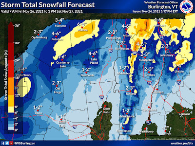
Update: First Friday/Saturday Snow Accumulation Forecasts

The National Weather Service in South Burlington this 
afternoon took their first crack at expected snowfall Friday
through Saturday. Yellow areas can expect at least six
inches. High elevation spots in darker orange could
get a foot or more. 
It's beginning to look like the spine of Vermont's  Green Mountains, and to some extent the western slopes of the Greens, the Northeast Kingdom and perhaps the northern Champlain Valley are in for a pretty good snowfall, especially Friday night and Saturday.  

The ingredients are still coming together for an upslope snow event. That's when winds are forced to glide up the western slopes of the Green Mountains, combined with lots of moisture wrapping around a storm to our northeast, will unleash a lot of snow. 

The thinking from the National Weather Service in South Burlington is that the spine of the Green Mountains from about the Sugarbush resort in Warren on north through Mount Mansfield and Jay Peak are in for a good 12 to 18 inch dump.

The western slopes - towns like Lincoln, Huntington, Underhill, Jeffersonville, Bakersfield and Montgomery might get a good six to 10 inches of snow. 

The Northeast Kingdom and perhaps the northern Champlain Valley away from the immediate shore of Lake Champlain could easily get four or five inches of snow out of this as well. 

If you're around the Burlington area, at this point it looks like you're going to see quite a gradient of snow accumulation. At Burlington's Waterfront Park, they'll probably barely manage a dusting to an inch. By the time you get out to Williston, we're talking about a possible four or five inches, if things work out as they now appear.

Note that forecasts can change. This is just an early read on the situation. 

Anyone who does get a lot of snow will see it stick around for quite awhile. It will stay too cold for any substantial melting at least through next Wednesday.