Showing posts with label flood risk. Show all posts

Saturday, August 1, 2026

Flood Threat In Vermont Diminishes For Next Storm, But Does Not Entirely Disappear.

More rain on the way, but it doesn't look like enough
to cause more flooding. Most places should see an
inch or less Sunday night and Monday, though a 
couple places could see locally higher amounts. 
Weather forecasters are a little more relaxed about the chances of flooding with the Sunday night and Monday.  

We're still going to get a bunch of rain Sunday night and Monday. And we hope you like humid weather because we have plenty of it coming up. But overall, we're in the midst of a decent summer weekend. We've been lucky with these weekends. 

REST OF TODAY

A good summer day is underway once again. We've had a lot of Saturdays like this. The sun will be out most of the time. As far as rain goes, there's the slightest of chances of an isolated showers over the mountains, but that's it. 

Highs will top out in the mid-80s for most of us. It is kind of humid out there, but it won't be as oppressive as it could be. 

SUNDAY

We should make it through most of the day without rain or thunderstorms. Especially if you're in the southeastern half of Vermont. A slow moving "cold front" will be coming approaching grudgingly fro the west. A have "cold front" in quotations because it won't really drop our temperatures and the drop in humidity when it eventually comes through will be barely noticeable, 

It will get close enough to set off some scattered showers and non-severe storms late in the afternoon north and west, but not everyone will get wet. It'll be in the 80s again, and you'll notice the humidity getting worse. 

SUNDAY NIGHT/MONDAY

This is when the bulk of the rain and downpours come through.  There had been some concerns that a sluggish, weak but very wet storm would stall nearby, giving parts of our area another drenching and flood, like what happened in New York's Hudson Valley earlier this week, 

Instead, it looks like things will slowly progress through, so that - fingers crossed - it doesn't rain hard enough or long enough to set off any flooding. There's still a chance some locally heavy downpours cause problems, but overall, the chance of anything major look low, 

The rain should be more good than bad.  Some places, especially in the Northeast Kingdom didn't receive all that much rain this past week. As it stands now, it looks like almost everybody in Vermont should receive a decent half inch to an inch, with maybe locally higher amounts. 

I supposed there's a slight chance the forecast could once again flip flop back to a rainier, somewhat more dangerous scenario. So far, I don't see that, but of course, we'll update as necessary.

REST OF NEXT WEEK

The dog days of summer I've been talking about will continue. The weather set up with an offshore Bermuda high means very warm and humid air will keep coming at us. Tuesday will be the nicest day with a slight dip in the humidity and low to no rain chances.

The rest of the week will be partly cloudy, humid, with an ever-present chance of showers and storms. It's hard at this point to pick out which day will be the rainiest. It depends on the location of any little disturbances in that muggy flow of air. 

The clouds and showers should keep us under 90 degrees (with possibly one or two odd exceptions) But the humidity will more than make up for the lack of super hot air. Um, enjoy, I guess?  


Wednesday, July 29, 2026

Flood Threat Continues Today In Southern Vermont And Southern New England

Forecast map for additional rain this morning through 
tomorrow. Some areas in far southern Vermont could
receive five or more inches of rain (dark red shading)
Amounts taper off dramatically as you head north. 
 If there's flooding in Vermont from this rainy episode, it will be today. And there's still a high chance of at least some trouble in southern Vermont. 

Late yesterday and overnight, the moisture flow went south to north, up through western Vermont and the Champlain Valley.

The rainfall was beneficial, especially in northwestern Vermont. More than an inch of rain fell in many areas as far north as St. Albans. 

So far, there's been no big flooding in the Green Mountain State, though street flooding occurred in Bennington yesterday afternoon. That town had received a storm total of 2.33 inches of rain as of 7 a.m. today. 

Flash flood warnings were in effect just to the southwest, especially around the Albany Capitol District.

Hardly any rain has fallen in eastern Vermont, especially the Northeast Kingdom. Up there, some places have only had a trace of rain.  

The moisture feed this morning is going to shift and intensify. The fire hose of deep moisture that was going north to south will rearrange itself to a southeast to northwest flow. That will direct the very wet air smack into the eastern slopes of the Green Mountains. The air rising up over the mountains will probably unleash periods of heavy rain. 

It still looks like the far southern Green Mountains will receive three to as much as five inches of rain today. There might be pockets that get a little more than that.  

Far southern Vermont remains under a moderate risk, alert level three out of four for flooding today. Even in places that through dawn had received little rain. The potential danger zone encompasses pleasant far southern Vermont villages like Wardsboro, Wilmington, Halifax, Readsboro, maybe Brattleboro and Newfane. 

Larger waterways to watch are Whetstone Brook around Brattleboro and the Deerfield River around Wilmington. A lot of the trouble today will come from small creeks and streams whose high water could demolish culverts or steep gravel roads.

Again, this won't be on the level of July, 2023, as rainfall rates shouldn't be as intense as they were then.  But it's still something to take seriously. 

The rainfall in southern Vermont will peak this afternoon into this evening, so I'd say the best chance of flooding would start from mid-afternoon and go well into the night.  Rainfall rates during the heaviest downpours could be in the one to two inch range. 

It helps that it's been dry recently. But rainfall at that rate in steep terrain can easily set off flash floods. I'm not suggesting everyone in far southern Vermont will see a flood today. But those areas bullseyed by the heaviest rain might. It's impossible to tell in advance who that will be,

People in far southern Vermont who live in a flood prone area should have a to-go bag ready, in case they need to bid a hasty retreat from rapidly rising floodwaters. Have more than one way to receive flash flood warnings so you know right away if trouble is looming. 

CENTRAL VERMONT

The fire hose of moisture will hit the Green Mountains in central Vermont, too, especially in Rutland and Windsor Counties. The flow wet air from the Atlantic Ocean might not be as intense or long lasting there. But we could see enough to touch off some flash flooding there. 

NOAA has this area under a slight risk - level two out of four on the alert scale for flash flooding. 

So you'll want to keep an eye out on small streams and brooks in towns like Ludlow, Cavendish, Springfield, Shrewsbury, Mount Holly, Chester, Weston, those kinds of areas.  Once you head north toward Northfield, Barre, Montpelier, and that area, there's a slight chance of a local flash flood, but I'm pretty much doubting anything will happen there, unless there's some sort of tremendous surprise. 

NORTHWEST VERMONT

That south to north flow of humid air yesterday and last night surprised us with some decent rains. Which were badly needed. As of 7 a.m. Burlington had scored 1.49 inches of rain. As noted, the orientation of the rain band is going to shift. 

Starting mid-morning or so, rain will turn  more sporadic and lighter. I don't see a flood threat up in the northwest, despite the heavy rain last night and early this morning,  some rain today and tonight, of course, but nothing to worry about. 

NORTHEAST KINGDOM

You need the rain and you're not really going to get it. So by the end of this episode, part of Vermont will see flooding, and part of Vermont will be desperate for rain. It'll rain a little up there in the NEK today through Thursday, but total amounts look to be less than a quarter inch in many areas.

SOUTHERN NEW ENGLAND

Widespread urban and small stream flooding is expected today in much of that region. 

Tuesday, July 28, 2026

Vermont Remains On The Edge Of Wild Weather Pattern; Slight Flood Threat But Not As Bad As Further 'South

The first rains of our wet period are seen yesterday
over Lake Champlain near Alburgh. Some areas of
Vermont will see a couple inches or more of rain, with
a localized flood threat. The Northeast Kingdome
looks like it will largely miss out
 As you've seen in the headlines, there's been a lot of rough weather in the United States this summer. 

One long stripe of the nation has really gotten nailed. It goes from Minnesota and Wisconsin, through the Great Lakes, into the Ohio Valley and finally the Mid-Atlantic States.

That zone has repeatedly gotten some horrible thunderstorms and even tornadoes. Repeatedly. With no real end in sight.

Yesterday, a nasty tornado swept through parts of northeast Wisconsin, trashing large sections of Menasha, Neenah and Appleton.  Also Monday, severe thunderstorms packing 80 mph winds and possible tornadoes harassed the Chicago area. Flooding was also reported. 

Today, severe thunderstorms will hit the Mid-Atlantic states again. More flash flooding is a risk, too, especially in the New York City metro area. 

 Here in Vermont, we've mostly gotten glancing blows from all this wild, weird summer weather. Sometimes, it does mange to hit us, like when we had that pair of tornadoes in June, or those destructive microbursts in the Northeast Kingdom and southern Vermont earlier this month. But we haven't gotten the worst of it in the Green Mountain State. 

This time around, we're on the edge of the "fun" today and tomorrow. We don't have to worry about severe thunderstorms. Flash flooding is a bit of a threat, especially in southern Vermont, but - fingers crossed - this doesn't look like it will be anything widespread or super destructive.

Though I'm pretty relaxed about the forecast, this kind of weather system can pull surprises. Things won't turn out exactly as the current predictions. I'll give it a go as to what will happen, based on what the National Weather Service is telling us this morning. 

TODAY

Forecasted rain fall through Friday morning, from the
National Weather Service. Note that rainfall 
amounts will be more variable than depicted here. 
There were some showers and thunderstorms and downpours yesterday, mostly in the Adirondacks, bu they were pretty widely scattered. 

That kind of stuff will be more widespread today. Especially the further west and south you go.

Based on radar images at 9 a.m. today. you'd think a big dose of needed rain would be starting in Vermont very soon. There was a big stripe of rain, with a few embedded downpours in the central Adirondack, extending down to places just west of Albany, New York.

But this stuff was just barely crawling eastward. And it looks like it will weaken as it does so.

However, more showers and thunderstorms will develop this afternoon as that slow weather system continues to press grudgingly eastward today. 

It will probably rain most places today, though showers and thunderstorms will be especially hit and maybe mostly miss in the Northeast Kingdom. 

Areas south and west of Interstate 89 have the best chance of seeing rain and downpours, possibly multiple hits. That's especially true down in far southern Vermont and up toward  Albany/Glens Falls/Lake George, New York and on its the Adirondacks, 

This area has the best chances of local flash floods today, though I'd emphasize that the chances of that happening are pretty low. Mostly because it's been so dry lately. Still, if any one place gets nailed by numerous downpours, one right after the other, then there could be a local high water problem

TONIGHT

Showers and storms will continue off an on. Since the wet airflow will come from the south and east, off the Atlantic, the best chance of heavier rain is on the east slopes of the southern Green Mountains and in the east slopes of the Adirondacks. 

Again, no widespread flooding, but there could be a pocket here or there the could have a creek or small stream overflow enough to damage a gravel road or driveway, or possibly damage a particularly unlucky  house. 

WEDNESDAY

By tomorrow morning, the center of our sluggish storm will be somewhere in the general vicinity of New York City, give or take. That set up will keep sending waves of showers northward into Vermont.  Again, the best chance of heavier rain is in southern Vermont. And maybe the eastern slopes of the Green Mountains maybe as far north as Sugarbush. 

If any flooding happens, it'll be in southern Vermont, especially in the steep slopes of the southern Greens. Again, so far at least, we're not expecting anything widespread. Definitely not a repeat of 2023, as it looks now. Even so, the creeks, small streams and brooks in southern Vermont especially will need to be watched. 

A saving grace is it looks like it will be too cloudy and too cool to allow any torrential thunderstorms to develop. So rainfall rates won't be as likely to produce flash flooding as we would see with a lot of thunderstorms. 

Once again, he Northeast Kingdom looks like it will be more protected from the rains. The White Mountains of New Hampshire might help block some of the Atlantic Ocean moisture that will be flowing into New England. 

THURSDAY

The stupid, slow, meandering storm will begin to depart. We'll still have some showers around, but the risk of heavy rain will diminish.

As noted, the rainfall will be super variable. One town might see more than two or even three inches of rain out of this, while a few towns over will see maybe a half inch to an inch. 

Broad brush, many areas south of Route 4 should get more that two inches of rain between now and Thursday. Some spots in the southern Green Mountains could easily go past three inches, maybe even approach four inches in isolated spots.

Central Vermont in general would receive one to 1.5 inches. Most of northern Vermont should receive an inch or less. Some places in the Northeast Kingdom could easily receive less than a half inch of rain, 

So, some places in Vermont will get too much rain, while other places not enough, It's still very dry in  northern Vermont, so a half inch of rain won't cut it. We'll need more, But at least the rain will cut back a burgeoning fire hazard. Brush fires were reported in recent days in Essex Junction and Fairfax. There probably were a few other small blazes breaking out in other parts of the state. 

Fortunately for the north and unfortunately for soon to be soggy southern Vermont, the weather pattern looks pretty active, though slow moving.  There's another potentially wet system that might come at us later Sunday or Monday. 


Sunday, July 26, 2026

Will The Vermont Rains Coming This Week Be Just What The Doctor Ordered Or Too Much Of A Good Thing?

Summer flowers this morning in St. Albans, Vermont.
The gardens are a bit parched and need rain. We'll
get some, but will it ultimately be too much?
Vermont is in for one more gorgeous summer day today. As previously advertised, this is one of the best weather weekends of the year. 

Today will be almost the same as yesterday, with highs in the 80s under generally sunny skies. There's a bit more wildfire smoke in the air than on Saturday ,but it shouldn't be thick enough to be hard on our lungs or dim the sun much. 

It looks like rain chances will slowly increase between tomorrow and Tuesday. But the showers and thunderstorms will be slow to work into Vermont. And there are big questions as to whether we will have a lot of rain or practically nothing. 

Even though the bulk of the rain will come between Tuesday and Thursday, we still don't know the outcome. We will have one of these three options: 

1. At least parts of the state get cheated, and needed rain doesn't materialize to any great extent So far,  this looks like the least likely scenario

2..Repeated showers and thunderstorms, and possibly a period or two of just steady rain comes through over the course of three days. But the downpours are not too excessive. So we get a nice soaker, but no threat of flooding. This is exactly what we want, and the forecast is leaning slightly toward this scenario. 

3. Too much of a good thing. The downpours linger and become frequent and heavy. There's so much rain that we end up with flooding problems. At this point, if this scenario does happen, it looks like southern Vermont has the highest rise. 

Here's how forecasts think things will happen, including the questions. 

MONDAY

Some scattered showers and thunderstorms might develop during the afternoon.  They're most likely to focus on the Adirondacks. Over here in Vermont, most of us won't see any rain. Perhaps 20 to 30 percent of us will see some at least some rain. It will stay very warm, with highs probably well into the 80s. It'll be slightly more humid than today, but not insanely oppressive.

TUESDAY

Here's where the question marks in the forecast really start. Tuesday through Thursday, it will depend on whether an upper level area of low pressure forms and nearly stalls. And exactly where it happens. 

For Tuesday, it looks like it will be more humid, with a greater chance of showers and storms than on Monday. If the weather system comes in as just a disturbance, we'll have a fair number of afternoon and evening showers and thunderstorms, but nothing incredible.

 If a an upper level low pressure system forms, the rain will be more widespread and the downpours heavier.  That could lead to isolated instances of relatively minor flash flooding. 

For now, Vermont, and most of New England for that matter, is under a marginal, level one out of four level risk of isolated flash floods

WEDNESDAY

This is the big question mark day. It'll pretty much definitely rain, at least somewhere in Vermont. The question is, will that upper level storm form, and if so, where will it meander?

If the upper level low does form and stall, somebody under or near it or could receive some flooding rain. Some weather models don't predict this storm to form. Others say it will, but it will happen south and east of Vermont, so no real trouble for us. A few other models have this thing over or near Vermont, opening the door for potentially torrential rains. 

I'm not sure which scenario will unfold. In fact, nobody is sure. So we'll have to wait and see.

For now, southern and central New England, including southern Vermont, is under a slight risk, level two out of four level risk of flash flooding. It's unusual to have that level risk three days in advance, so we'll have to watch this. 

I'm not raising flood alarms yet, but we'll have to watch this.

THURSDAY

Still some lingering showers, but whatever weather system will be harassing us will be starting to move out.  

As always, we'll see how this develops.  It is one of those situations in which we won't know how this will play out until we get much closer to the event. 


Saturday, June 20, 2026

Surprisingly Heavy Vermont Rainfall Raising Some Flood Concerns.

Just a few hours after the main band of strong 
thunderstorms departed on Thursday, the first in
a series of rain showers arrived that evening, as
seen here in St Albans. Several rounds of showers,
some heavy have come through since then. More
showers and possible downpours are
due today and Sunday.
An odd risk of some scattered flooding as developed in northern Vermont despite cool northwest winds that usually prevent that sort of thing. 

That big storm we had Thursday, the one that gave Vermont two tornadoes and other damaging wind storms, is  now lumbering around eastern Quebec into the Canadian Maritime provinces. 

 The storm is sending bands of showers southeastward out of the Canadian Maritimes into mostly northern and central Vermont. 

Rain has been maldistributed in Vermont most of this month anyway. Northern Vermont, especially the Northeast Kingdom, has been getting lots of rain. The southeast corner of Vermont, which was still facing lingering dryness from last year's drought, has not gotten all that much rain at all.

During Thursday's storm, the Northeast Kingdom was drowned again. Several towns in north central and Northeast Vermont received more than two inches of rain from Thursday's storms. Meanwhile, the southeast corner of the state had some damaging thunderstorms Thursday, but they were quick hitters that only deposited a third to a half inch of rain. 

Yesterday, bands of rain, some of it heavy, sank slowly southward through the northern half of Vermont. Each individual shower in the band moved fast, but the showers were all following one another, like boxcars on a freight train, so surprisingly heavy rains fell. Southern Vermont got nothing.

Through midnight last night, Burlington has already received 4.3 inches of rain so far this month. The normal for the entire month of June is 4.26 inches, so we're already above normal for June. More rain fell early today. Some of it was heavy. 

Around 1:30 a.m. today, the National Weather Service office in South Burlington issued a flood warning  for much of Chittenden County, parts of Addison County, and the western slopes of the Green Mountains roughly between the Middlebury Snow Bowl an Smuggler's Notch due to a heavy period of overnight rain. 

The warning has since expired, and I haven't seen any flood reports yet, but I image some steep gravel roads or driveways might have suffered some damage.  

Usually, the amount of rain that falls in this type of weather situation with a west to northwest wind is quite light. But the disturbance rotating around the backside of that storm and into northern New England are pretty dynamic and energetic, and able to produce some locally heavy rains. 

TODAY

An interesting satellite photo shows a band of
heavy showers across north central Vermont Friday
while the south remained mostly clear. Those
showers produced locally heavy rain. 
This state of affairs will continue today. One area of showers was coming through northern Vermont as of 7:30 this morning. 

It contained brief downpours but the area of rain wasn't big or intense enough to set off any flooding. But it kept wetting the soils and helping rivers stay elevated. 

If we get more downpours today, I don't expect any serious river flooding, but there could be some local washouts, erosion things like that. 

The larger rivers are running high, which should make you think twice about taking a kayaking trip along those waterways. 

More disturbances will rotate through today. It'll be rather cloudy, especially north, but enough sun will get through to increase the instability in the air. This will create numerous showers and garden variety thunderstorms, but some of them might contain heavy rain. 

In general northern Vermont will see between a third and three quarters of an inch of rain today. But places in the mountainous terrain mostly north of Route 2 could see locally more than that, which could trigger isolated instances of flash flooding today. 

Highs will only be in the upper 60s and low 70s under the clouds and showers.

SUNDAY

Same old, same old. More rounds of showers and storms, mostly central and north. Highs will be a little warmer with temperatures getting into the 70s for most places. It'll still be a few degrees cooler than average. 

Once again, some showers or storms could produce some downpours in the northern mountains, so isolated flash flooding is possible again. Under normal circumstances, I wouldn't worry about flash flooding tomorrow, but the ground is so saturated in the north that it could happen. Like today, if any flooding happens, it will be very localized. This weekend will be no means be a replay of the horrible summer floods in 2023 and 2024.

Rainfall this morning through Sunday evening will range from two inches or a little more in a couple spots in northern Vermont to less than a tenth of an inch near the Massachusetts border. 

The U.S. Drought Monitor lists an area of Vermont south and east of a line from Bennington to roughly White River Junction as abnormally dry, so the rain misses down there are annoying. But there's hope.

MONDAY

A small, fast moving but very wet little storm is forecast to scoot by to the south of Vermont on Monday. There's still some questions about how far north its heavy rain will extend. But chances are far southern Vermont could receive a really good soaking out of this. 

If everything works out right, Bennington and Windham counties could receive a couple inches of rain ou of this little storm. 

Amounts will taper off the further north you go.  This could change, but central Vermont could get moderate amounts of rain out of Monday's system. The sopping wet north would only get a little bit of rain. Which is great because that scenario would mean no risk of additional flooding. 

Long range forecasts can never be trusted, but predictions through the end of the month in indicate a slow warming trend and frequent chances of showers and thunderstorms through June 30 

Friday, June 6, 2025

Friday Vermont Early Afternoon Update: "Locally Significant Flash Flooding" Possible in Southern Vermont This Afternoon, Evening

Forecasters are now saying "locally significant flash 
flooding" is possible this afternoon and evening
in parts of southern Vermont, along with much 
of New Hampshire and northern Massachusetts. 
UPDATE: 2:30 PM FRIDAY

Concern is rising in far southern Vermont for the risk of flash flooding this afternoon and evening.  

By 2:15 p.m, pockets of heavy rain and thunderstorms had already developed over the southern Green Mountains.

A large patch of drenching rain, meanwhile, was moving in from the west, beginning to affect most everything south of a Burlington to Newport line,

The part of this drenching patch of rain heading into southern Vermont should intensify as it hits humid, more unstable air there. 

Plus, more torrential thunderstorms should develop, mostly south of Route 4. 

Early this afternoon, NOAA's Weather Prediction Center, put out a statement warning of the risk of "locally significant flash flooding" in steep and hilly terrain of the southern Green Mountains,

This potential significant flash flooding extends into the Berkshires of Massachusetts and much of southern New Hampshire, especially the Monadnock Mountains. 

In these areas - again including the southern Green Mountains - local areas might see as much as three to five inches of rain of rain in just a few hours. Rainfall rates could briefly reach two inches per hour, which is a big indicator of a flash flood risk, 

The ground is also very wet already in southern Vermont, so it can't absorb all that much water.

Some flash flooding is possible as far north as central Vermont, but it won't be potentially as severe and widespread as in the south. 

Take this one serious, especially if you live in southern Vermont, the southern half of New Hampshire and the western half of Massachusetts. 

There were no flash flood warning in effect yet as of 2:30 p.m., but the worst of the rain hadn't arrived yet. The threat will peak between roughly at between roughly 3 to 8 p.m., but could linger beyond that.

If you live in an area prone to flash flooding, have a to-go bag ready now, and a planned route to escape.  Also, some of you in southern Vermont might be temporarily trapped behind washed out back roads, 

It's honestly too late to run out and get food and stuff in advance of any flooding. You don't want to be caught out on the roads, especially ones near small creeks and streams when the rain really hits. Those streams can go from placid brooks to roaring rapids sometimes within minutes.

Not every town in southern Vermont will see a flash flood. But it's time to be on your toes through the rest of the afternoon and evening. Just in case. 
 
PREVIOUS DISCUSSION FROM THIS MORNING
Once again, some localized flood risks have popped
up today. In Vermont, southeastern parts of the 
state especially have a chance of local but
to widespread flash flooding. 

Thunderstorms in Vermont were fewer and further between on Thursday than expected, though some of the some of the widely scattered storms eded up being pretty strong. 

We have no reports of any damage so far, so it doesn't look like any of the storms achieved severe status. 

A couple strong storms originated in or near Addison County and crossed over the Green Mountains to areas north White River Junction. I'm sure some of those towns along the way did experience a rambunctious storm. 

90 DEGREES

The relative lack of thunderstorms Thursday also meant more sun, allowing Burlington to achieve its first 90 degree day of the season. 

That was a day later than expected.  Some forecasts called for 90 degrees on Wednesday, but the city didn't quite make it, stopping at 88 degrees.  The mostly sunny skies that lasted until at least mid-afternoon Thursday let Burlington briefly sneak up to 90 degrees in the mid-afternoon. 

The first 90 of the season has been coming earlier in the season recently, compared to, say a generation ago. That's owing at least in part to climate change. The first 90 of the season on Thursday was earlier than historically common. But compared to the last 20 years, it was sort of so-so early.

In the past decade, four of Burlington's first 90 degree day of the season came at a later date than June 5.  In 2015, the first 90 didn't hit until July 28.

The earliest in the season first 90 came on April 17, 2002. Burlington has had a handful of years, like 1998, 2000 and 2004 with no 90 degree days at all. 

TODAY'S STORMS

We're going to have two very different Vermonts today and tonight. Southern Vermont will be stormy and wet. With even a risk of some flooding and severe storms.

Northern areas, not so much, though a little rain should creep in. Right near the Canadian border it might not rain at all, or it does, it won't amount to much.

Which means all eyes are on southern Vermont.  Yesterday's weak cold front stalled and has become a warm front, which will drift ever so slowly into central parts of the state.

South of the warm front, the air is humid and unstable, which suggest lots of showers and thunderstorms. Especially this afternoon.

The principal threat is local flash floods. There's a level one marginal risk of flash flooding in central and southern Vermont, with a somewhat more substantial level 2 slight risk of flash floods in extreme southeast Vermont. (And in western Massachusetts and the southern half of New Hampshire.)

A few spots in southeast Vermont could see two to as much as three inches of rain in a short amount of time this afternoon, which suggests flash flooding is a possibility there.  It won't be widespread, but a few places are at risk.

I'd say the steep terrain of the eastern slopes of the extreme southern Green Mountains, and the lowlands just to the east where the water will flow has the best shot of flash flooding. 

I'd keep an eye on Whetstone Brook in and near Brattleboro today, and nearby streams, just to be on the safe side. No guarantees of flooding there, but if you've got stuff that can be easily moved away from the brook or those surrounding streams, do it this morning, just in case. 

There's no flood watch currently in Vermont, but flood watches are in effect immediately adjacent to the Green Mountain State in Massachusetts and New Hampshire. 

Another secondary problem in far southern Vermont is severe storms. A few could contain strong damaging winds, maybe a couple of microbursts. Nothing at all like Austin, Texas had on May 28, but a couple towns in far southern parts of the state could suffer some localized tree and power line damage. 

A level one marginal risk of severe storms, meaning isolated damaging winds at most, is in effect for areas along and south Route 4. As of early this morning, level 2 slight risk is up for central New England, just barely creeping into southeastern Vermont around Brattleboro and Guilford.  

SATURDAY

Believe it or not, Saturday is looking....OK. At least in the afternoon and evening. I'm not holding my breath, given our recently history, but at least some of us might enjoy some sun as the afternoon wears on and evening approaches.

At least it won't be a complete washout like last Saturday was. 

Southern Vermont will still have the worst weather in the state, just as they will today. It'll be a rainy morning, as Saturdays in Vermont now seem to be required to have rain. But skies should brighten by mid to late afternoon. Except maybe in far southeast Vermont, where it could remain cloudy all day. 

The further north you go, the less rain and the less chance of rain you'll see.  In fact, it's possible parts of Vermont close to the Canadian border might break the sacred Saturday "rule" and see no rain at all!

Bottom line. If you have outdoor plans Saturday in Vermont, the later in the day they start, they better off you'll be,

The only fly in the ointment later in the afternoon is a secondary cold front will come through. That could touch off a few isolated showers and storms, but nothing widespread at all.

SUNDAY

Another miracle might hit Sunday.  At least some of us in Vermont should end up with a Chamber of Commerce kind of day. You know, perfect for the tourists. After a comfortable night for sleeping overnight Saturday, Sunday's highs should reach the mid 70s, at least in the valleys. The humidity should stay nice and low. 

 Places away from the mountains should have mostly sunny skies, with just some puffy clouds around over the mountains, to make the photos and background for your selfies that much prettier. 

There will probably be still some Canadian wildfire smoke in the atmosphere, so the sky might not be a brilliant deep blue on Sunday. The blue might have that bit of a slate gray tint to it because of that smoke. I guess not everything can be perfect. Still, the smoke shouldn't be as thick as it was earlier this week, and I don't anticipate anything serious enough to prompt air quality alerts. 

If you're in the mountains, the skies could get a little cluttered with those puffy clouds in the afternoon, so the sun won't be consistent there. But it will still be nice. No rain!


Thursday, May 8, 2025

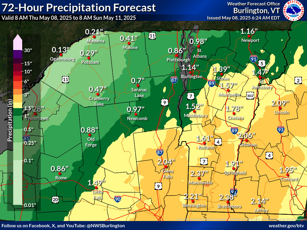
Super Soaker Coming For Vermont/New England Before Weather Pattern Change

Forecasts for Friday and Saturday have taken a turn 
toward a real soaking.  One to as much as three
inches of rain could all. This is one forecast
map for rainfall. Results will vary, of course. 
 Those forecasts for rain Friday and Saturday definitely escalated, and now we're due for a real drenching here in Vermont and the rest of New England over the next couple of days. 

Not that it hasn't already been wet.  The first week of May featured rain every day, some of it heavy in southern Vermont.

Woodstock, Vermont has already had 2.43 inches of rain so for in May. Normal for the entire month there is 3.61 inches. 

They'll be above their normal May installment of rainfall by the time Saturday evening rolls around. 

One to three inches of rain is coming to most of Vermont between late tonight and Saturday night.  The fact that this drenching is falling on sodden ground, especially in southern Vermont, raises the possibility of flooding.

So far, though, it looks like any flooding that does hit should be on the minor side. So, knock on wood, I didn't jinx our "Vermont escapes dangerous weather in 2025" pattern I waxed so poetic about in yesterday morning's post.

Which I wrote before forecasts changed from "we're going to get light rain," to "prepared to get very, very wet."

TODAY

The low pressure area that's been tormenting us all week isn't giving up without a fight. Light rain showers continued to roam at least northern Vermont this morning. It's also going to be cooler than we've gotten used to. Under cloudy skies, highs should stay in the 50s north, near 50 in the Northeast Kingdom. Southern Vermont should reach the 60s 

FRIDAY/SATURDAY

As expected, a brand new upper level low is replacing the one we've been dealing with all week.  What's changed is both the path of the this thing, and a corresponding sort of nor'easter that will be forming. 

This nor'easter-ish thing will slowly meander from around New Jersey to eastern New England between Friday and Saturday, all the while throwing ton of moisture from the Atlantic Ocean into the Northeast.

It looks like the heaviest rainfall with this will be in central New England, including southern Vermont. There 1.5 to 3 inches of rain seems likely

Since the ground is already wet, not much new rain will soak into the soil, so it will run off.  This might be enough to set off some minor flooding along rivers in southern Vermont. 

The rain forecast is enough for the National Weather Service to hoist a flood watch for Bennington and Windham counties in Vermont, along with parts of Massachusetts and the Capitol District of New York.

The good news is the rain will be spread out over a couple days. That means we won't see the sort of short, sharp downpours you get in thunderstorms. So the risk of sudden flash flooding is really low. 

Central and most of northern Vermont should get about an inch of rain out of this, maybe close to two inches in a couple spot. This won't be enough for flooding. 

It will just make for a damp, chilly and soggy Friday and at least part of Saturday.

From this vantage point, Saturday does not look like a nice day, but it will be on an improving trend din the afternoon and evening.

MAJOR PATTERN CHANGE

If you're tired of the rain, I have some news for you!

The weather pattern looks like it wants to flip to  a summer-like one for next week. 

Sunday will be nice and sunny and seasonable, but after that, it'll get noticeably warmer.  And, eventually, kinda humid, too. Here comes summer.

We won't be breaking high temperature records, but next week will feel a bit like July. Highs will be within a few degrees of 80. Lows early in the week will be in the comfortable 40s and 50s.

But from midweek on, you might notice it'll turn a little muggy. Not oppressive and awful, but more like typical summer.  You'll hope for breezes coming in through open windows at night.  

It won't be a rain-free pattern.  Sure, Sunday and probably Monday and maybe next Tuesday look dry But scattered showers and thunderstorms should enter the picture by midweek.   

Sunday, March 16, 2025

Sunday Morning Storm Update: Death Toll Up To At Least 34, Tornadoes To Wind Down; Vermont Still Expecting Flooding

Tornado destruction his weekend in
Diaz, Arkansas, Photo via Facebook
by Ronnie Burgess 
The death toll from the storms that rolled through the United States rose to 34 as of early this morning.

Twelve of the deaths were caused by tornadoes in Missouri. In Mississippi, six people are dead, three are missing and 29 are injured. 

In Kansas, eight people lost their lives, not in tornadoes, but because they got caught in blinding dust storms on highways, causing numerous crashes. 

The bottom line is this was the most U.S. deadly disaster so far this year. The January wildfires in California caused 29 deaths. 

More tornadoes swept through the South Saturday, causing more destruction.  Today, more tornadoes could strike in a stripe from western Pennsylvania to Florida. A tornado warning was already effect early this  morning a little north of Augusta, Georgia. 

So far there have been at least 58 reports of tornadoes from the Midwest to Southeast Friday and Saturday. 

After today and tonight, the storm should finally depart the United States after leaving that trail of wildfire destruction, dust storm debris, tornadoes and flooding. 

New storms will cross the nation in the coming weeks with more packets of severe storms, tornadoes and wind, but these next storms so far do not look as intense as the one the U.S. has just endured.

VERMONT WARMTH/FLOODING

The "Woof River" what I call the tiny stream running
by my St. Albans, Vermont home, was running high
and muddy yesterday amid rapid snowmelt and
temperatures in the upper 60s. If you look closely
at the black soil on the left, you can see daffodil
shoots starting to come up. The area in this
photo was buried in snow and ice just three days ago. 
After a very warm Saturday and overnight last night, water levels in rivers are starting to rise.  Those water levels were still well below flood level this morning, but will continue to come up today as the snow continues to melt away.

High temperatures Saturday reached 67 degrees in Burlington, and 69 degrees in Bennington, and all the way to 70 degrees in Rutland.  As of 7 a.m. this morning, the temperature had not gotten below 50 degrees in Burlington. That's warmer than I've seen on some July early mornings. 

The expected rainfall has been postponed just a bit until the end of today.  That will allow temperatures to hit 70 degrees in the warmer towns today. That's a good 30 degrees above normal for this time of year, so it's pretty incredible. 

The bottom line to all this is remaining snow will continue melting very fast and contribute to the risk offloading. 

So far, flood forecasts call for a few rivers to reach at least minor flooding.  The Mad River is expected to get to 10.5 feet tonight, which is just a little under moderate flood stage.  The Otter Creek in Center Rutland, and the Missisquoi River in North Troy are also forecast to reach flood stage.

Other rivers - so far - are forecast to not quite reach flood stage.  However, water levels this morning were generally a little higher than predicted. Which means it's possible that flood levels could get a little higher than this morning's flood crest predictions. 

We'll also have to keep an eye on smaller streams and creeks.  Rapid snow melt can turn a small stream into a torrent pretty quickly.  We could see local washouts and culvert damage. Especially since things are still unstable from last summer's flood. That could make things a little more susceptible to damage. 

One bit of good news is predicted rainfall tonight in Vermont is a little less than previous forecast. Still, it will be briefly heavy, with a chance of a rumble of thunder.  Expect a third of an inch to an inch of rain in most place in the Green Mountain State between now and midday Monday. 

As of this morning, there's still ice on some of the river.  We still might see some ice jams, which can cause some rapid local flooding.  I think the most likely river to see any ice jams is the Missisquoi.

Needless to say, a flood watch remains in effect for all of Vermont through Monday evening. 

It's actually going to stay on the warm side this coming week.  Not as warm as this weekend, but still balmy for March. It looks like we might get a little more rain, too.  However, by then, so much snow will have melted that I'm not too worried about renewed flooding.

By the way, the water level of Lake Champlain is starting to rise, and will continue to do so.  But the chances of ever reaching flood stage are iffy.  It depends on how much snow and rain falls the rest of this spring, and how intensely it falls.

Flood stage is 100 feet. As of yesterday, the lake level was at 95.44 feet, up about half a foot in the sag week. That pace of lake water rise will accelerate the next few days, but will stop short of flood stage.

Lake Champlain probably won't flood significant this year unless the rest of the spring is particularly rainy and snowy.  

Wednesday, August 21, 2024

A Summer Of Upper Level Lows Creates Strange Weather, We Are Experiencing The Latest Now

Upper level forecast map from NOAA for this
evening. One upper low spinning over northern
New England, and another northwest of Washington
State heading southward toward northern California.
 This is ending up being the summer of odd upper level cut-off low pressure systems that are all promoting strange, and sometimes dangerous weather here and elsewhere in the nation. 

An upper level cut off low is a storm in the upper levels of the atmosphere that's separated - or cut off- from the jet stream. 

Since the jet stream isn't there to push them along, these upper level lows - which are really pools of cool air aloft - tend to meander and move slowly. That, in turn, causes sometimes extended periods of unsettled, bad, or even dangerous weather. 

The latest of these upper lows is over us now.  I wouldn't say what we're experiencing this time is especially dangerous, though it does have its hazards.

Our current upper low is over-performing, as so many weather systems have lately. It's stronger and more persistent than many previous forecasts indicated. It's producing more rain than prior predictions hinted at too.  It's pretty damn chilly under this thing, too. 

Some places around Vermont will have near record low high temperatures today. Burlington missed that record by just two degrees Tuesday, as it only reached a high of 62 degrees. Burlington won't break that record today.  The lowest high temperature on this date was 58 degrees in 1982.  It was already 58 degrees as of 

I had said for the past several days that the rain with this system would fall far short of creating any flood risks. 

It turns out that it actually might cause issues, but the risk is pretty low. The upper low is pretty much right over us, which means any showers that get going today will move very slowly. 

This afternoon, the contrast between the meager (and I do mean meager) warmth near the surface and the very cold air aloft will give the showers a convective feel. Instead of the bland gray overcast with light rain we had this morning, things will evolve into tall billowing clouds which could produce local downpours. 

NOAA's Weather Prediction Center has actually put us under a marginal risk of excessive rains or local flash floods today. 

I still don't think this will end up being a major issue, though. There might be local, minor problems, but as you've surely noticed, we're lacking the deep tropical humidity that can lead to torrential downpours. So we're not going to have flood havoc today. 

Satellite view of a cut-off low centered over central
New England on the evening of July 29. This 
system would go on to cause a devastating flood
in the Northeast Kingdom of Vermont
several hours after this pic was taken. 

But since scattered afternoon downpours might have such a slow forward motion, we'll have local issues with ponding of water on roads, and minor washouts here and there, especially where recently repaired roads and driveways haven't been packed down and stabilized yet after prior flood damage. 

OTHER CUT OFF LOWS

Other upper level cut off lows have caused strangeness, and worse, scary danger here and elsewhere this summer. 

It was a meandering upper level low that tapped into deep tropical moisture that unleashed horrendous downpours on the Northeast Kingdom back on July 30.  We all know the calamity that caused. Don't worry, nothing like that will happen today in Vermont. This is a completely different situation. 

A more recent upper level low (related to the one we're dealing with now) contributed to dangerous flooding in and near Toronto last Saturday and deadly flooding in Connecticut on Sunday. 

Yet another cut off low is heading southward along the Pacific Northwest coast. It promises to briefly interrupt a very hot, dry summer in California and probably will lead to a very rare summer snowfall up high in the Sierra Nevada mountains. Snow levels could go as low as 7,600 feet above sea level.

Strong, dry winds ahead of this system are likely to stir up California, Nevada and Oregon forest fires today, making them especially dangerous. 

I'm not sure whether these upper lows are related to climate change or not.  Likely not. But the torrential rains associated with some of them probably are. As the atmosphere warms, it can hold more moisture. Meaning that when you get "perfect" setups, like July 30 over the Northeast Kingdom, it means the downpours end up being heavier than they would have been decades ago. Meaning bigger disasters. 

As for our that upper level cut off low meandering overhead in Vermont today, it will get a push to move slowly to the northeast and out of our hair by Thursday night. By Friday and the weekend, we should be back to our regularly scheduled, late summer warm but not hot weather. 

Monday, August 19, 2024

Intense Flash Flooding In Northeast, And Ontario, Some Vermont Flood Risk Today

Extreme flooding again, this time in Connecticut on
Sunday. Photo from WINY Radio via Facebook. 
 While we in Vermont were harassed by scattered, mostly light showers and overcast skies on Sunday, new outbreaks of intense flash flooding hit other areas not too far from the Green Mountain State. 

Parts of Connecticut were under a flash flood emergency when up to ten inches of rain deluged the southwest parts of the state in a matter of hours. That led to a disaster on par with what happened around St. Johnsbury and Lyndonville on July 30 when eight inches of rain fell in a few hours there. 

The flooding in western Connecticut Sunday was described as a one in a thousand year flood event, which means the chances of what happened yesterday in any given year is 0.1 percent. Of course, in the age of climate change, I think this percentage chance need to be altered.

Up to ten inches of rain fell in just a few hours. In some western Connecticut towns, up to six inches of rain fell in just three hours. 

Unfortunately, reports are two people were swept away in the Connecticut flooding but deaths had not been confirmed as of this morning.

As you'd expect damage is severe, with many roads washed out. Homes and businesses are trashed. The same story we've heard way too often this year.

Meanwhile, in Ontario, five inches of rain drenched Toronto Saturday, setting off new rounds of flooding in a summer that has already seen intense flooding in Ontario.  Once again, people had to be pulled from cars suddenly stranded in rapidly rising water. 

This will be Toronto's wettest summer on record, according to Environment Canada.   The wettest summer on record in Toronto was previously 15.6 inches of rain, but already this summer, they've had 18.73 inches and counting. 

Here we go again. Vermont under a slight
risk for flash flooding today. 

I'm struck by how frequently the floods have been in the Northeast and southeastern Canada this summer. Central and northern Vermont on July 11. Vermont's Northeast Kingdom on July 30.  Toronto, Canada on July 15 and August 17. Montreal on August 2. Now Connecticut.

MORE FLOODS?

Today brings one last day for awhile for some flood threats in New England, including here in Vermont. 

The cold front that promises to bring in that chilly air we've been advertising is set to come through today.  NOAA's Weather Prediction Center has upgraded us from a marginal to a slight risk of excessive rain and flash flooding across Vermont today.

That is level two out of four-point scale. 

These risks are always tricky to assess in advance.  Sometimes, the heavy rain moves right along and doesn't linger over one area, minimizing the flood threat. Other times, heavy downpours hit the same area over and over again, and you have a local flash flood.

Today is kind of a tossup, so we'll have to wait until this afternoon to see how everything behaves. 

We know the line of storms ahead of today's cold front will have some torrential downpours. It's just a question of whether they linger over a particular spot for a couple or few hours.  Especially if it lingers over the Green Mountains, that could cause trouble, as the rainwater would gush down the steep slopes and cause some flash flooding.  

If we get any flash flooding in Vermont today, it'll happen between 1 and 8 p.m., says the National Weather Service in South Burlington.  Any flash flooding would take the form of washed out culverts, gravel roads and ditches, flooding of the type of small streams that rise quickly in heavy rains, and street flooding in urban areas. 

I don't think flash flooding today will be super widespread. Most of us should only get 0.75 to 1.5 inches of rain, which is manageable. But a few unlucky spots could get much more. 

The National Weather Service said this morning the ground is still so soggy that we can only handle 1.5 to 2 inches of rain in an hour before flash flooding would probably begin. Some towns that get hit by the heaviest downpours today could see that much rain in such a short time period. 

Seek higher ground very quickly if your area goes under flash flood warning.

We won't have to worry about flooding along main rivers like the Winooski, Lamoille, Missisquoi, Mad rivers and Otter Creek.  Those rivers will see sharp rises overnight, but won't go over their banks or cause anything scary or really damaging. 

I always hate to talk about flash flood risks because we Vermonters are so jumpy now when it comes to floods.  It's happened so much and so frequently, any forecast that mentions flooding probably triggers PTSD in more than a few people.

But, it will be over by this evening, so at least we don't have to sit and worry for very long.

COLD SNAP

As the chilly air pours in this evening, any Vermont flood risk will evaporate for the foreseeable future. The cold air in the atmosphere will probably trigger a fair number of rain showers Tuesday, Wednesday and possibly part of Thursday.  But all those showers will be light and pose absolutely no flood danger. 

After that, it should stay dry until at least next Sunday, or possibly even longer. 


Thursday, August 8, 2024

Thursday Evening Update: Flood Risk Continues In Vermont/New York With Debby; Rather Weird Weather, Too

Expected rainfall amounts through Saturday with
the remnants of Debby. Less rain is expected in
Vermont than earlier forecasts, which will help prevent
another big flood disaster. But local flash loods
are still a real risk. 
As advertised, clouds increased this afternoon across Vermont and surrounding areas as now ex- Tropical Storm Debby makes its way towards us.  If it isn't raining where you are when you read this, it will soon.  

THE BIG PICTURE

Already, as of 5 p.m. rain had moved into far southern Vermont and in northwestern New York. There were a few heavy downpours embedded with that rain. A sign of things to come. 

The overall forecast for its track, timing and duration hasn't changed much since this morning. The 5 p.m update from the National Hurricane Center actually has it moving a little faster than they predicted this morning. 

This morning, the projection was former Debby would be over northern Vermont as of 2 a.m. Saturday. Now, it's expected to be just north of the northern tip of New Hampshire at that hour.

The faster former Debby moves the better, as it would have less time to dump a bunch of rain on us. 

Heaviest rain is still expected to be across northern New York with this thing with somewhat lighter totals in Vermont. 

The National Weather Service office in South Burlington has updated its flood watches, expanding the watch across all of the northern half of Vermont except the Champlain Valley. 

Although trends have continued to minimize the threat of another mega-flood disaster in the Green Mountain State, instances of flooding, washouts, that kind of thing are still definitely in play. 

That northern Vermont flood watch was put in place largely because areas hard hit by the two other big floods this summer are especially vulnerable to heavy rain. 

The State of Vermont, and towns affected by that flooding hurriedly patched up washed out roads and culverts just to get the roads open. More permanent repairs come later. 

Since a lot of those quick repairs are ad hoc, they're not particularly  resilient against heavy rains. So downpours associated with ex-Debby that in normal times wouldn't be that big a deal are. Ex-Debby might undo a lot of the work that's been done in the past month. 

STEP BY STEP OUTLOOK

Tonight

Overnight, chances are you'll hear the occasional roar of quick downpours on your roof, interspersed with periods of lighter rain or no rain. Overall, radar has rain coming in quicker than I thought, so you might see a shower even before sunset. 

Overnight, rainfall will only amount to maybe a quarter of an inch in southern Vermont, with locally higher amounts. Northern Vermont can expect maybe a half inch to an inch. 

This won't be enough to trigger flooding but will prime the pump for possible flooding later, as I noted this morning. 

Friday/Friday Evening

A weird, tropical day. There might be a lull in the rainfall early in the morning, but it should pick up in the form of numerous showers and thunderstorms in the afternoon.  The day will feel incredibly humid and south winds could get a little gusty with this, too.

 Former Debby is still expected to cross over northwestern Vermont. With tropical storms and former tropical storms thunderstorms tend to develop along and east of the path, with a steady, heavy rain west.

So the steady, heavy rain will mostly stick to New York. 

The more sporadic nature of the numerous showers and storms will make things a bit challenging for forecasters. Areas of flash flooding - and flash flood warnings - won't become apparent until the actual flood is underway, or the flooding is just minutes away.

Though we know that most of us will receive one to two inches of rain, there could be much higher totals in a couple spots if storms hit the same spot over and again.

If we do see any flash flooding with this, the best chance of it hitting are between early afternoon and midnight Friday.

Definitely be ready to hear any flash flood or severe thunderstorm warnings that might be issued tomorrow. It will be an active day and evening .

Some of the storms could end up being severe, with a few reports of damaging gusts definitely possible.  Vermont is now in a marginal risk for severe storms Friday and Friday evening, meaning there could be isolated instances of damage. I do wonder whether that risk level will be upgraded to slight tomorrow, which is a slightly higher risk of severe weather. 

Tropical systems can be prolific tornado producers. There have already been several in the Southeast. There is a low, but not zero chance of a brief spinup with former Debby in Vermont tomorrow and tomorrow evening. Could happen anywhere in the state. If it does happen, the best chance is in southwestern Vermont. 

Outside of those severe storms, winds could gust to 40 mph in spots Friday afternoon and evening. That could be enough to push over a few trees. Remember, wind can uproot trees more easily if the soil is wet and soggy. So expect a few widely scattered power outages, even if no severe thunderstorms develop.

Saturday

Since this ex-Debby thingy will be rocketing by so fast, it now looks like Saturday will be a nice day. Although the chances of serious river flooding in Vermont appears low, we'll have to watch those water levels, especially Saturday morning if the rain we get Friday and Friday evening turns out to be heavier than expected. 


Some Cautious Optimism This Morning Regarding Debby, Flooding And Vermont

 I'll make one thing clear: 

Expected rainfall with Debby. One to two inches expected
in most of eastern Vermont, with two to four
inches northwest and mountains. Note that this is
a broad brush map. Locally higher amounts could
be embedded in some areas. 
There's definitely still a flood risk here in Vermont as we await the arrival of what will then be former Tropical Storm Debby.  Chances are more than decent there will be at least some damage around somewhere in Vermont. 

But - fingers and toes crossed big time - this is looking less like the wholesale new big disaster for Vermont than it did two or three days ago.

OVERALL TRENDS/NEWS

Forecast trends continue to keep remnant Debby zipping by and heading to Canada really quickly, which would limit the time the storm has to dump torrential downpours. And while those downpours are likely in at least part of Vermont, the biggest focus for them should be in the Adirondacks.

Not that I want that to happen. I'd  hate to see the kind of destruction in New York that we saw in Vermont earlier this summer.  But Vermont can sure live without another big flood, too. 

NOAA's Weather Prediction Center still has almost all of Vermont in a moderate risk zone for flooding with this. That's level 3 of 4 on the risk scale and definitely a sign of potential trouble. That said. it's possible that moderate risk in Vermont might be trimmed back later today in some areas if relatively happy forecast trends continue. We shall see! 

We're not completely out of the woods, of course. As mentioned, we're going to get some pretty stiff downpours. And there's still a few question marks regarding the exact track of what will be former Debby. 

For now, the National Weather Service in South Burlington is confident enough about heavy rain in the Adirondacks to issue a flood watch there.  No flood watch is in Vermont, at least not yet. There's some high resolution data that was just coming in early this morning they wisely want to take a look at first before making any decisions on whether to hoist any flood watches in the Green Mountain State. 

I notice flood-spooked Vermonters are taking no chances, which is a smart move. The city of Barre, repeatedly hit hard by recent floods, is making sandbags available for residents and businesses. 

Let's walk you through what meteorologists think will unfold as this thing goes by. As you're reading, remember, the forecast is subject to change. The paths of tropical storms and former tropical storms can be really unpredictable.

TODAY

Another nice one as the humidity remains low and bright sunshine bathes the state. At least for awhile. You'll notice increasing high cloudiness this afternoon, as what will be former Debby begins its charge toward us. 

It'll be a seasonably warm day with highs in the 77 to 83 degree range most valleys

TONIGHT

The burst of high humidity that tropical systems always bring along with them will ooze quickly in, turning the night from refreshing to muggy by morning. This blast of humidity will trigger a band of rain with a few embedded heavy downpours and thunderstorms. 

This won't be enough to trigger any flooding, but could prime the pump for flooding that might come with later bursts of downpours from Debby.

FRIDAY

It's going to be kind of a weird, tropical day. That band of initial rain will move out.  You'll notice the oppressive, awful humidity we had through most of July and the opening days of August will be back. Don't worry, this outbreak of air you can wear will be brief.

Especially on the Vermont side of Lake Champlain, there could be fairly long periods during the day with no rain at all. Or, there will be fitful, quick hitting showers that might not amount to all that much.

At first.

But especially if we see a fair number of breaks in the clouds, that could destabilize the air and trigger some torrential thunderstorms. We'll have to watch those for the risk of any isolated instances of afternoon and evening local flash floods. There won't be anything widespread, if anything at all, but it will be worth watching.

FRIDAY NIGHT

The heart of the storm, and when the greatest risk of flash flooding might happen. The steady, heavy rain should continue all night in the Adirondacks. Debby is actually using Vermont as sort of a meet up spot with a cold front coming in from the west.  

The two will team up to come through Vermont probably with a band of heavy downpours. (Latest projections from the National Hurricane Center has the center of former Tropical Storm Debby about over Morrisville at 2 a.m. Saturday)

The band of storms will be moving fairly fast, but since the rain will come down so hard, in many cases on already sopping wet soil, the risk of flash flooding goes up. Note that nighttime flash floods are dangerous, as they're hard to see and you might be sleeping when warnings go up. Have a way to wake up to warnings if you live in a flood-prone area.

 There's cautious optimism on main rivers like the Mad, Winooski and Lamoille, and the Otter Creek. All those waterways will have sharp rises, but so far, only minor flooding at worst is in the forecast. That could change if rainfall amounts and patterns change from what is now in the forecast, but for now, again, fingers crossed. 

There might also be a problem with wind in spots overnight Friday. Even though former Debby will be rather weak by the time it gets here, there will still be a fair amount of energy with it. Strong winds aloft could mix down to the surface overnight. That's especially true perhaps along the western slopes of the Green Mountains and maybe the Champlain Valley.

We won't have any ferocious windstorms like we did this past January, but gusty winds hitting trees on soggy, unstable soil could topple a few of them, causing some scattered power outages.

SATURDAY AND BEYOND

The remnants of Debbie should quickly scoot away, so most of the day should be rain-free. We'll need to watch how high main rivers get during the day, but as noted, I think we might be OK. We could really end up with a nice summer day on Saturday. 

Beyond that, a weak dip in the jet stream might promote scattered showers and rumbles of thunder, mixed with periods of sun Sunday through Tuesday. The showers will be light and widely scattered, and pose no flood threat. 


Wednesday, July 31, 2024

Wednesday Evening Vermont Flood Update: So Far, Mostly So Good, But New Flash Flood Warning St. J/Lyndonville

Threatening clouds, but so far very little rain in St. 
Albans, Vermont so far today. Can't say the same for
some areas of the state that faced some pretty good 
downpours. Spotty flash flood risk lasts into the
evening, even though we've dodged a bullet so far.
UPDATE 7 PM

OK, bullet NOT dodged.

Just as I feared in my evening update an hour ago, enough rain has fallen in the Northeast Kingdom to prompt a flash flood warning.

The warning includes towns hit super hard yesterday, including St. Johnsbury and Lyndonville.

Up to two inches of rain has already fallen, and up to another 1.5 inches is anticipated soon.

The ground is so soggy and unstable there, that that amount of rain is more than enough so set off flash flooding.

So far, the flash flooding in the Northeast Kingdom doesn't appear to be as extreme as it was Tuesday. However, any added damage and trouble is just more misery for a Northeast Kingdom population that has already been through far too much. 

PREVIOUS DISCUSSION 

As of 6 p.m. this Wednesday evening all the flash flood warnings so far seem to be focused on New Hampshire.  Not good for them, but so far, Vermont has mostly dodged a bullet. 

However, a few more bullets might fly our way before the evening is over.  We'll still have to wait and see for the next few hours. 

Slow moving downpours are still crawling through the Green Mountain State. The risk of flash flooding is still there, especially in the Northeast Kingdom.

We have seen quite a few downpours around.  Very hit and miss, though. Some pinpoint places have received more than an inch of rain, while others, like here in St. Albans, had seen just a trace of rain and some rumbles of thunder through 6 p.m. 

The downpours that have limped southwest to northeast across Vermont have further "primed the pump" for possible local flash flooding if they get hit by more torrents of rain.  A flood advisory was hoisted this afternoon for parts of Bennington County, where one to two inches of rain fell in a short period of time. 

I'm noticing some pretty heavy rain has moved into Caledonia and Essex counties as of 6 p.m., so that will need to be watched closely. That's the zone that was so hard hit by Tuesday's floods. Which means even relatively brief downpours can set off more trouble and more damage. 

I'm also watching a heavy area of rain in eastern Addison County, which was moving quite slowly over steep terrain. That could cause trouble. 

Even though we haven't really had any major problems yet, the risk is probably peaking between now and about 9 p.m. as the day's rain - at least where it really poured - is beginning to add up. 

No guarantees we'll have flash flood problems. We might well get lucky.  But it's too soon to let your guard down. Let's wait and see what the next few hours bring.  

Friday, June 21, 2024

Heat Is Flushed Out, Humidity Not So Much, Weekend Storm/Flood Threat?

Roiling storm clouds over Milton, Vermont Thursday.
 Just as expected, some powerful thunderstorms formed over much of Vermont yesterday, with scattered reports of damage here and there.  

The worst of it was probably across the pond in Plattsburgh. The airport there measured gust of 61 mph.  There might have been higher gusts on those grounds, given the fact a small plane was flipped over and a few other planes moved around. 

Here in Vermont, it seems the strongest storms were in Chittenden County, where some trees came down in the North End of Burlington, along the lake in spots and in Charlotte.  The National Weather Service office in South Burlington reported a 48 mph gust. The storms extended into central Vermont, as Stowe reported some tree damage.

With that extremely humid air in place, the storms had a lot of moisture to work with and boy, did they take advantage of it! One report had an inch of rain in Burlington in just 15 minutes. We saw quite a bit of street flooding in parts of Burlington and South Burlington. 

Some local flash flooding was also reported in far southeastern Vermont. 

The good news is the heat advisory that had been in effect for three days has been dropped. It is a little cooler out there, and the humidity has diminished a little, too. At least in northern Vermont. 

We're by no means in the clear, though. We have more humid weather to get through, and the risk of storms and heavy rain/flooding through at least Sunday.  The weather is still going to be pretty active, folks! 

Let's take a walk through what's lined up next. 

TODAY

Dew points, a rough measure of how sticky it feels, were in the 60s this morning across Vermont. That's rather humid, but not quite as bad as this past week has been. 

Storm clouds loom over Colchester, Vermont
Thursday afternoon.

Dew points are in the more comfortable 50s up in southern Quebec and a little bit of that drier air might bleed briefly into far northern Vermont, which will be nice.

Yesterday's cold front is hung up in central New England. That means new rounds of showers and storms today, mostly in the the southern half of Vermont.

 Some of the storms could produce local deluges, and there might be some isolated instances of flash flooding.

The showers will be more scattered the more north you go, with not much excitement at all north of Route 2.

SATURDAY

That stalled front will start to lift back north through Vermont Saturday.  The humidity will become more and more noticeable during the day. But clouds will keep temperatures mostly in the 75 to 82 degree range, so the heat's not coming back. At least not here. It'll be torrid in the Mid-Atlantic states and Ohio Valley this weekend, but not really here. So that's good. 

The risk of showers and storms will last all day in the south, and there will be increasing chances through the day north. Saturday night looks pretty rainy, too.

With all the humidity around, we once again have the risk of heavy rainers in some of these showers and storms, so isolated flash flooding is again a risk.  This time statewide, not just in the south. 

SUNDAY

Depending on how things arrange themselves, Sunday could have its dangers. If that slowly moving front stalls across northern Vermont, the risk of flash floods would ramp up.  Storms will train along the front. You know what I mean, those proverbial boxcars following each other one after another. 

You could get inches of rain out of such a situation. 

Storms create chaotic looking skies over
St. Albans, Vermont late Thursday afternoon.

The computer models keep subtlety changing their minds on this, but the early bets are leaning toward the front stalling in far southern Quebec instead.

 If that happens, it would shift most of the flash flood risk across the border and not here. So stay tuned.

We're not completely out of the woods if the front stalls in Quebec. If it does, that puts all of Vermont in warm, soupy air. 

With a front and storm system approaching from the west, that would put us in play for strong, possibly severe storms. 

We'll have more on Sunday as we get closer to the event, stay tuned.

In central and southern Vermont, all this storminess might do more good than harm. Despite the storms yesterday, it's still pretty dry in those parts of the state, and more rain would come in handy. 

NEXT WEEK

Instead of one big heat blast, we're going to have pretty changeable weather.  Things could change, but Monday looks showery, Tuesday looks nice, Wednesday could be warmer and more humid with possible storms. 

But here's something you'll like. A cold front Wednesday or Wednesday night looks like it means business.  If that really does happen, we might get a nice, cool, dry blast from Canada. Bonus: There's far fewer wildfires up there than last year, so when we do get some refreshing air from Canada this summer, it's not full of smoke. 

However, even if we do get that nice cold front, hot air will be lurking not far to our south, and it would probably have an easy time oozing back into our neck of the woods.