
 |
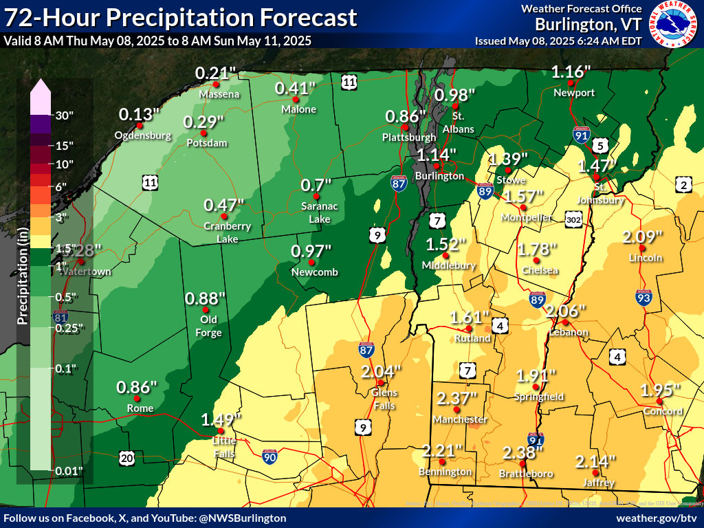
| Forecasts for Friday and Saturday have taken a turn toward a real soaking. One to as much as three inches of rain could all. This is one forecast map for rainfall. Results will vary, of course. |
Not that it hasn't already been wet. The first week of May featured rain every day, some of it heavy in southern Vermont.
Woodstock, Vermont has already had 2.43 inches of rain so for in May. Normal for the entire month there is 3.61 inches.
They'll be above their normal May installment of rainfall by the time Saturday evening rolls around.
One to three inches of rain is coming to most of Vermont between late tonight and Saturday night. The fact that this drenching is falling on sodden ground, especially in southern Vermont, raises the possibility of flooding.
So far, though, it looks like any flooding that does hit should be on the minor side. So, knock on wood, I didn't jinx our "Vermont escapes dangerous weather in 2025" pattern I waxed so poetic about in yesterday morning's post.
Which I wrote before forecasts changed from "we're going to get light rain," to "prepared to get very, very wet."
TODAY
The low pressure area that's been tormenting us all week isn't giving up without a fight. Light rain showers continued to roam at least northern Vermont this morning. It's also going to be cooler than we've gotten used to. Under cloudy skies, highs should stay in the 50s north, near 50 in the Northeast Kingdom. Southern Vermont should reach the 60s
FRIDAY/SATURDAY
As expected, a brand new upper level low is replacing the one we've been dealing with all week. What's changed is both the path of the this thing, and a corresponding sort of nor'easter that will be forming.
This nor'easter-ish thing will slowly meander from around New Jersey to eastern New England between Friday and Saturday, all the while throwing ton of moisture from the Atlantic Ocean into the Northeast.
It looks like the heaviest rainfall with this will be in central New England, including southern Vermont. There 1.5 to 3 inches of rain seems likely
Since the ground is already wet, not much new rain will soak into the soil, so it will run off. This might be enough to set off some minor flooding along rivers in southern Vermont.
The rain forecast is enough for the National Weather Service to hoist a flood watch for Bennington and Windham counties in Vermont, along with parts of Massachusetts and the Capitol District of New York.
The good news is the rain will be spread out over a couple days. That means we won't see the sort of short, sharp downpours you get in thunderstorms. So the risk of sudden flash flooding is really low.
Central and most of northern Vermont should get about an inch of rain out of this, maybe close to two inches in a couple spot. This won't be enough for flooding.
It will just make for a damp, chilly and soggy Friday and at least part of Saturday.
From this vantage point, Saturday does not look like a nice day, but it will be on an improving trend din the afternoon and evening.
MAJOR PATTERN CHANGE
If you're tired of the rain, I have some news for you!
The weather pattern looks like it wants to flip to a summer-like one for next week.
Sunday will be nice and sunny and seasonable, but after that, it'll get noticeably warmer. And, eventually, kinda humid, too. Here comes summer.
We won't be breaking high temperature records, but next week will feel a bit like July. Highs will be within a few degrees of 80. Lows early in the week will be in the comfortable 40s and 50s.
But from midweek on, you might notice it'll turn a little muggy. Not oppressive and awful, but more like typical summer. You'll hope for breezes coming in through open windows at night.
It won't be a rain-free pattern. Sure, Sunday and probably Monday and maybe next Tuesday look dry But scattered showers and thunderstorms should enter the picture by midweek.
No comments:
Post a Comment