 |
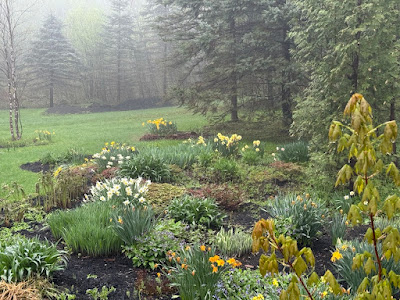
| A foggy, very wet garden in St. Albans, Vermont this morning after the drenching rains of yesterday and last night. Drier weather is coming. |
As of dawn Saturday, it had been raining continuously in the state for about 24 hours. It was still raining, though the trend was beginning to get more showery. There were bursts of fairly heavy rain here and there, mixed in with periods of just very light drizzle.
Rainfall totals are over an inch statewide. As of 6 a.m., Burlington was one of the "dry" spots with a mere 1.23 inches so far.
Not many reports have come in from elsewhere yet. That'll happen later this morning. But we already have a report of 2.1 inches out of Elmore. I've added up totals at reporting stations and came up with 1.7 inches in both Bennington and Rutland as of 6 a.m.; about 1.5 inches in Montpelier and around two inches Springfield.
We do have one flood warning to report, and that's from the usual suspect, the Otter Creek in Rutland County. Flood stage along the Otter Creek in Center Rutland is eight feet. The river is expected to crest at 8.6 feet later this morning.
Low lying roads along Otter Creek from about Clarendon north into Addison County might go under water, so keep an eye out for that.
The Mettawee River at Granville, New York, just over the border from southwest Vermont is in minor flood stage too. Since part of the Mettawee runs through extreme western Vermont, around Pawlet, there's probably some high water there, too.
 |
| Raindrops gather on a magnolia bloom in St. Albans Vermont this morning after a drenching rain. |
The Winooski River at Essex Junction will probably peak just a little under minor flood stage. Just be wary that rivers will run high and swiftly for a few days, so if you go out for some early season kayaking or whatever, currents could be dangerous.
The National Weather Service in South Burlington will keep the flood watch going in southern Vermont through this evening. Even though the rain will be tapering off today, runoff could keep rivers high through the day.
WHAT'S NEXT
The thick clouds and rain kept temperatures in the 40s for many of us Friday. So if you thought the day was remarkably chilly for May, you were right.
Since the clouds might thin a bit later today, it'll get a little warmer, but not much.
Sunday will be quite a different day than it's been, except for one thing. It'll still be on the cool side. The sky will be blue, the sun will shine brightly on our newly green landscape. But a stiff north wind will keep temperatures in the 50s to low 60s.
That coolness might make you worry about frost Sunday night. I think some places well away from Lake Champlain could see some frostiness by Monday morning. But the Champlain Valley looks safe.
We're still forecasting basically a week of summer coming up next week. We aren't exactly going to see a heat wave. But many with highs in the 75 to 82 degree range and lows in the 50s to low 60s, it'll basically be a nice week in July. Except in May.
Sunday, Monday and Tuesday look like they will be rain-free. If that happens, it'll be the first time since mid-March we've gone a full three consecutive days without a drop of rain. At least as measured in Burlington.
That doesn't mean the entire week will run without the risk of some showers. As we get into the second half of next week, we'll have a rising chance of scattered showers and thunderstorms.
It's too soon to say how much, but I don't expect a drenching like the one we just had yesterday and last night.

No comments:
Post a Comment