Showing posts with label mountains. Show all posts

Thursday, May 28, 2026

Yes, It's A Cold Shot Coming To New England, But Not THAT Cold

I always post National Weather Service snowfall prediction
maps in the winter. I couldn't resist posting their snowfall
forecast for this weekend. As you can see, an inch or less
is expected in the high elevations, with maybe a couple
inches atop Mount Marcy, New York. 
 I've been hyping up the so-called cold snap and mountaintop snows coming Friday night and Saturday morning, but we actually should't complain. The weather over the next few days in Vermont really won't be that awful. 

Even Saturday won't be a total disaster. 

It's true that yesterday was the last warmer than normal day we'll see in Vermont for awhile. But this time of year, it can get dreadfully hot and humid.  We don't have to worry about that! 

In the past, it's also gotten much colder than what we're expecting this weekend.  For instance, the record low high temperature on Saturday in Burlington is 50 degrees. The forecast high is 59. 

Instead of all that, outdoor temperatures will be comfortably in 60s daily today through next Tuesday, except for Saturday. And there's no chance of frost except maybe in the coldest hollows of the Northeast Kingdom

We'll call today and tomorrow partly to variably cloudy with just a chance of isolated showers. It will be dry most of the time. Later Friday afternoon will tend to cloud up with a rising chance of showers north as our fast moving "bowling ball" of cold air comes toward us, fresh from the  Arctic Circle. 

THE COLD AIR

The pool of cold air will be over us mostly overnight Friday and Sunday morning. That's when the bulk of the rain (and snow!) will fall. There will probably be a dusting of snow at elevations above 3,500 feet and in higher elevations of the Northeast Kingdom. 

Rainfall for us valley dwellers will vary a lot, with less than a quarter inch south, a third of an inch maybe in the Champlain Valley, a half inch north and east of Interstate 89 and maybe more than three quarters of an inch in the Northeast Kingdom.

Saturday morning will certainly be cold and raw, but some breaks of sun will make things OK in many areas by mid to late afternoon.

SUNDAY-TUESDAY AND BEYOND

Those highs in the 60s during this period will be about five to 10 degrees cooler than average, but well take it. We'll have periods of sun, but also the risk of showers. So it will be the run inside when the rain hits, and a half hour later, it's back outside into the sunshine. t's hard to time out when, those showers might arrive, but the best chance is probably Sunday night and Monday. 

For those of you who like warm summer weather and dislike this cool stuff, there's hope for you, too. The weather pattern will start to change during the middle of next week, and it looks like we'll have at least spells of average to somewhat warmer than average temperatures starting the second half of next week. 

The usual caveat applies: Long range forecasts are iffy, so no promises! 

Saturday, December 13, 2025

Snow Continues To Set Records In Vermont's Green Mountains

A snowy view of Vermont's Mount Mansfield from
January, 2021. This year, it's especially wintry up
there. As of Friday, there was 63 inches of snow on
the ground near the top of the mountain, a record
for so early in the season. 
 The ski and riding season is off to the best start in memory over Vermont's Green Mountains with another boatload of snow up there this past week. 

There is a hiccup looming in the snow parade, but for now (more on that in a minute) But for now, it's pretty wild up there. 

The snow depth near the top of Mount Mansfield, Vermont's highest peak, reached 63 inches on Friday, breaking the old record depth for the date of 56 inches. 

The 63 inch snow depth is the earliest in the season on record for so much snow.  Until Friday, the snow depth up there had never gotten to 63 inches any earlier than December 26. 

In a typical winter, there's 21 inches of snow on the ground up there this time of year. Mount Mansfield usually doesn't have 63 inches of snow piled up until early February.   

The folks up at Jay Peak near the Canadian border, said they received about two feet of snow in the 36 hours ending early this morning. Snowfall so far this season up there is 185 inches. Their Saturday snow report says that's the most they've ever seen for so early in the season. 

That Jay Peak report also gave us this statement:  "The amount of snow is starting to feel borderline terrifying, but it skis like a dream." 

It's rare for ski areas in Vermont to have all their terrain open this season, but all of Jay Peak's alpine and Nordic trails are open as of this morning. 

Elsewhere, both Smugglers' Notch and Stowe have already had more than 100 inches of snowfall this season so far.

This has really been a mountain snow blitz, with Vermont valleys kind of sitting this one out. Snowfall so far this season has been a little more than average in northern Vermont valleys and definitely nothing special in the low lands of southern Vermont. 

So far this season, Burlington has had 18.9 inches of snow, which is 6.7 inches ahead of normal as of Friday. St. Johnsbury has had 13.4 inches of snow so far this month, which means they're running a little ahead of average 

What makes the snow even more remarkable in the northern Green Mountains is the lack of thaws since Thanksgiving.  That's a rarity for December, especially in recent years when record or near record warmth has often hit during the last month of the year. 

This year's cold December weather has contributed to the deep snow cover in the mountains. In the valleys, snow cover is pretty substantial for this time of year, but not record-breaking. Two towns near Jay Peak, Westfield and Montgomery, had 20 inches on the ground as of Friday, which is a lot. 

Greensboro had 16 inches, but I couldn't find any other towns listed by the National Weather Service as having more than a foot of snow covering the landscape. 

OUTLOOK

There might be a little more snow today, but most places around Vermont should receive an inch or less. The mountains could pick up two or three inches, but this will be a minor little event. 

A few more light snow showers look like they'll come through Monday night.  But for the most part, nature's snow hose is temporarily just a dribble. 

The powder party in the mountains looks like it'll finally get interrupted around Thursday. By then, a well-anticipated weather pattern change will have gotten established. Instead of pushes of cold air from Canada, we'll have a  really fast, west-to-east flow across the United States.

This will allow squirts of warm air to come up ahead of storms zipping along in that flow. The first of these will probably come through here around Thursday, as mentioned. At this point,  it's looking like some rain will come with it, even in the high elevations. 

Details on this forecast are still a bit iffy, and subject to change, as always. But for now, it does look like the fast motion of the storm will mean the rain and the thawing won't last long enough to melt a huge amount of snow, and it probably won't really rain hard.  Plus, I imagine there will be a little snow at the tail end of the storm as a parting gift. 

After a brief cooldown, there might be another system next Sunday sort of similar to Thursday's zipping on through. 

Some of the computer models are hinting at a larger storm probably just after Christmas. But it's way too soon yet to figure out if there will indeed be a storm, and if so, what type. 

It seems there's some sort of good sized storm somewhere around Christmas almost every year. So this is a good reminder to bank extra time if you're traveling over the holiday in case the weather goes south. 


Sunday, December 7, 2025

Vermont Sunday Morning: Back To The Slowly Deepening Snow Pack Amid Cold December

The next round of snow this afternoon and tonight
looks light and fluffy, but will add to the deep snow
in the mountains. As you can see in this National
Weather Service map, many places in northern
Vermont can expect a good two inches of new
snow by tomorrow morning, while southern
Vermont valleys get very little. 
It snowed a little again last night in much of northern Vermont, part of a slowly deepening snowpack that has been really piling up in the Green Mountains since early November. 

Most places got an inch or less last night, with a few places receiving nothing at all. But a couple more inches hit the central and northern ski areas.

The difference between valley and mountain in terms of snow cover is always wide. This year, it's extreme. 

In the Champlain Valley, Burlington has had 13.3 inches of snow this season as of yesterday, which is 4.4 inches above normal. Respectable enough, but some of the Green Mountains are absolutely bonkers with snow.   

Jay Peak is always basically a snow globe, but this year it's ridiculous. The ski resort there reports 22 inches of new snow in the first week of December for a total so far of 141 inches. 

Even if you factor in ski resort snow report inflation, they've had an impressive early winter so far. Jay Peak has  definitely dropped the warning, "early season conditions exist" from their snow report, since conditions are more like midwinter.

Up on Mount Mansfield, there was four feet of snow at the measuring stake just below the summit. That's close to a record depth for this time of year. On average, snow cover at the Mount Mansfield stake does't reach four feet until late January. 

Between the persistent cold weather that's been great for snowmaking and the manna from the snow gods, this is Vermont's best start to ski season in years, maybe even decades. 

NEXT UP

Coming up: A, little more snow. 

This afternoon will only make it into the 20s - maybe upper teens in the high elevations north. If you saw glimpses of sun this morning, that's it for bright skies today as that next wave of light snow moves in this afternoon.  

This will be another mostly northern Vermont thing, with two to as much as four inches of fluff overnight. Even northern valleys should get at least two inches of snow. Amounts will taper off once you get into the valleys in southern parts of the state. Those places will get a dusting at best.

The cold regime we've been enduring will continue big time as we start the week, too. Burlington - and numerous other valley towns - managed to sneak above freezing briefly Saturday. That was our big thaw, I guess.

The snow should pretty much end before dawn in most spots. But that new snow, and blowing snow, and temperatures plummeting into the single digits means we'll once again deal with a crappy morning commute on the roads Monday morning. I know. Sigh. 

Monday itself will be another frigid day as we only make it into the teens during the afternoon. That's about 20 degrees colder than average for this time of year.  Then, tomorrow night, it's back below zero for many of us. 

Tuesday looks quiet and cold, as temperatures recover into the 20s. 

The next storm comes along Wednesday. Again, it'll be a not-that-big affair. And since it's going by to our west, it'll push another brief squirt of warmer air into the region. By "warm" I mean near normal for this time of year. 

Since the warmer valleys might get into the 30s, some rain might mix in during the day. But the mountains will pretty much remain snow through the entire storm.

Starting Wednesday, a gigantic blast of Arctic air will come into the U.S., eventually affecting everyone north and east of a line from Montana to Georgia. 

Yesterday I mentioned we might get a second storm on Friday. It's beginning to look possible that the g huge gush of frigid air might be so strong that it would suppress that second storm to our south, and we'd miss out. It's a little soon to tell for sure. 

We do know that temperatures will be heading downhill later in the week once again. Plus, there will be disturbances in that icy air flow that will trigger more snow from time to time, especially in the northern Green Mountains. So the snow will continue to deepen in those mountains through the entire upcoming week. 


Tuesday, November 18, 2025

Vermont Mountains Buried In Snow, But Weather Now Going Quiet

We weren't able to get all of the flower pots and deck 
furniture put away before winter weather arrived a 
little over a week ago here in St. Albans, Vermont. 
There's still snow on the ground, and forecasts
indicate it won't melt away quickly. 
Most of the snow that kept falling and falling and falling on many of Vermont's mountains is finally pretty much over as of this morning. 

The snow depth near the top of Mount Mansfield reached 38 inches by late Monday afternoon, the deepest on record for the date.

 There have only been six other November dates since 1954 with more snow on the ground on than on Monday. 

Those six dates were all in the Novembers in 1990 and 2018.  

This doesn't predict what kind of winter we're going to have. In Burlington, the winter of 1990-91 was the ninth least snowiest  on record in Burlington. The winter of 2018-19 was the tenth snowiest on record, 

On Sunday and Monday, the mountains collected almost all the snow, with valleys pretty much avoiding almost everything. True, many towns in the Northeast Kingdom managed a few inches, but everyone outside of the Green Mountains and their western slopes.

On the western slopes, Underhill Center saw 9.8 inches of new snow, and Fletcher got 8 inches. Most places got less than an inch. 

The almost daily snows we've seen in the Vermont mountains are pretty much shutting off for awhile. 

Instead, we're going to have a probably sort of brief interlude of boring weather. Which is par for the course for November, and, frankly a bit of a relief from the admittedly badly needed storminess we've recently experienced.  Drought relief is still welcome

Actually, the whole nation is getting a break from recent storminess. Only modest storms will cross the United States for the next few days. 

For us, we'll have quiet weather today through Thursday. There might even be a little bit of sun each day, especially on Wednesday. How about that for a change?  

It's been chilly, and unfortunately, or fortunately, depending on your perspective, it's not going to warm up much over the next three days. It'll get to 40 degrees in some of the broader valleys, which I suppose is an improvement over the past week or so. 

If you still have snow on the ground, it's not going to go away quickly.

One of those "meh" storms will come through us here in Vermont around Friday. Since it will be somewhat warmer than it's been lately, most of the precipitation with this thing will come down as rain. Even in the mountains. 

This won't be a big storm at all, so no flooding, no drama. Just a little wet weather for the end of the week. 

Computer models have been hinting it might really warm up around Vermont in the closing days of November, at least for a little while. But some of those forecasts are backing off on that idea. I'm doubting we'll see any truly balmy late autumn weather in the foreseeable future. 

Meanwhile, we still have some uncertain signs of a return to more exciting weather once we get into December.  That just means a more active weather pattern. It's too soon to tell what "exciting" will mean once we get past the Thanksgiving weekend. 

Sunday, November 16, 2025

Green Mountains In Vermont To Get Buried In Snow By Monday

National Weather Service snowfall prediction map.
Practically nothing in some valleys, but closing in
on two feet on some mountains by Tuesday.
 The first part of our storm is over, the one that dumped a cold rain, and in some areas freezing rain overnight. 

All the was expected, and was the easy part of the forecast for this storm. And those forecasts were pretty accurate.

Now comes the tricky part. 

We have a big, classic, upslope snow event for the Green Mountains. That's when moisture-laden air, propelled by stiff northwest winds, slams into the west slopes of the mountains. The air is forced to rise up and over the mountains. 

Rising air cools. Cooler air can't hold as much moisture as milder air. So the cooler air sheds the excess moisture it can't handle as precipitation. In this case, it means snow. Lots of snow.

This type of weather scenario happens all the time, every winter in Vermont. This episode will be bigger than most of them. 

The broad brush part of the forecast is easy. We know it's going to snow a lot in the Green Mountains, especially in central and northern Vermont. We know the summits of the Green Mountains will get nailed. Few of us  will be surprised if Jay Peak gets a couple feet. That's the mountain that almost always gets buried the most in this type of situation.

We also know very little snow will come down in places like the southern Champlain Valley and the Connecticut River Valley, roughly south of Wells River. 

It's the details that are tricky.  Especially in towns on the edge of the heavy snow zone. Places that get barely an inch or two will be very close to places that get six inches, even 12 inches. 

Probably the trickiest areas to forecast are in western Vermont, east of Route 7 all the way from Pownal to Highgate. 

Right along Route 7, there probably won't be much snow at all. But heading east from Route 7, snow totals will rapidly rise.  But where will that sharp increase start? In Chittenden County, will you start seeing a fair amount of snow in Williston? Or will you need to get to Bolton or the eastern part of Jericho to find pretty deep snow?

I live on Route 36 in St. Albans. Near the lake, on that road, they'll be lucky to get an inch of snow. I live on the transition zone on Route 36 on Fairfield Hill. I wouldn't be surprised to see at least a couple inches of new snow at my house. 

But two miles up the road, at the top of the hill, there could be double the amount of snow over what will be in my back yard. Bakersfield, about 13 miles east of my place, could get a foot or more of snow.  

As I began writing this at 8 a.m. Sunday, the northwest flow has just barely started. We were getting snow flurries in St. Albans at that hour, and weather radar shows the beginnings of this upslope snow. 

The heavy snow will peak from this afternoon through early Monday. 

A winter storm warning is unsurprisingly in effect for much of northern Vermont near the Green Mountains.    As mentioned, snow amounts will vary widely between valleys and mountaintops.

It also looks like much of the Northeast Kingdom should get a fair amount of snow with this. Winter weather advisories are in effect up there. A winter weather advisory is up for Franklin County, too, where, as mentioned, snowfall will be super variable. 

Further south in Vermont, the mountain snows won't be quite as heavy. But it'll be noticeable. A winter weather advisory is in effect down the spine of the Green Mountains from central Vermont to the Massachusetts border. 

The National Weather Service is going for three to six inches, with locally as much as ten inches in this winter weather advisory zone. 

No matter where you are this afternoon through tomorrow, it's going to be windy. Expect gusts over 30 mph in most places, with a few gusts over 40 mph. 

Where it will be snowing hard, expect a lot of blowing and drifting snow. Almost blizzard conditions, really. 

By the way, the Adirondacks of New York, especially the northern and western Adirondacks, will get buried, too in this situation. Same is true for some of the White Mountains of New Hampshire. 

The bottom line: I'd avoid travel this afternoon through Monday morning along high elevation mountain roads. You know the places: Roadways like Route 17 through Buels Gore, Roxbury Gap, Route 242 and 105 way up by Jay Peak, the back roads near and east of towns like Bakersfield, Enosburgh, Cambridge, Underhill, Huntington, Ripton. 

The snow will finally tend to lighten up and stay closer to the immediate Green Mountain ridgeline starting later tomorrow into Tuesday. 

Most ski areas won't be open yet but I'm sure there will be some people hiking in for some powder skiing.  

Friday, November 14, 2025

Cold, Cloudy, Often Snowy Vermont November Revealing Some Quirks

Traffic cam image from yesterday afternoon shows
a lot of snow falling along Route 105 in Jay, Vermont.
If you think it's been a cold November in Vermont so far,  you're absolutely right. 

Through yesterday, the month is running 2.9 degrees cooler than normal, as measured in Burlington. 

Remember, that's the "new normal," based on the average of Novembers from 1990 to 2020. By then, climate change had really started taking hold. 

Average Novembers used to be colder than they are now. This month isn't coming anywhere near close to becoming among the chilliest on record. But we're surely noticing how wintry this month has been so far. 

Still, this chill is a departure from most recent Novembers, though 2019 was notably cold. On November 13 of that year, the temperature in Burlington fell to 9 degrees above zero, the coldest for so early in the season.

What's been notable this month so far are the comparatively warm nights. The coldest it's gotten in Burlington so far this month is 27 degrees. It usually gets at least that cold by Halloween. A spoiler, though: The forecast low in Burlington tonight is 24 degrees.

That's still not especially chilly for this time of year. 

SNOWY MOUNTAINS

It really, really snowed in the central and northern Green Mountains yesterday. I could tell something was happening up there from my perch here in St. Albans. It snowed all day here. Not hard, and it often mixed with rain, so our accumulation was just 0.2 inches. 

But just go a little higher in elevation than where I am at 650 or so feet, and things really started to pop with the snow. 

The snow depth atop Mount Mansfield by late yesterday afternoon was 22 inches. Since records started up there in 1954, only 1976 and 1990 had deeper snow at this date. 

I don't yet have any specific reports of snow accumulation from just yesterday, but I'm dying to find out how much Jay Peak got.

The early deep snow in the mountains doesn't necessarily mean we'll have a snowy winter. 

The winter of 1976-77 was a little snowier than average in Vermont, but had less snow than all the other winters in the particularly snowy 1970s winters.

The winter of 1990-91 in Burlington had just 42.5 inches of snow, far below the normal of 78 inches. 

FORECAST

The moist, cold northwest flow has dried up a little since yesterday, though we will see some scattered snow showers today. Again. Now that the snow has started, it doesn't seem to want to end. At least not everywhere. 

Most of whatever snow we get today will be in the mountains. 

However, the National Weather Service in South Burlington has flagged one interesting potential today. There might be a band of lake effect snow setting up off of Lake Champlain. It it happens, you might see it snowing it places like Charlotte, Ferrisburgh, Monkton and Hinesburg, that area. The snow band might jump all the way over the mountains to places around Rochester and Granville. 

Those places might get an inch of snow, maybe a tad more. 

When the Lake Champlain temperature is as warm as it is now, lake effect snows can drop a few inches of snow in the central and southern Champlain Valley. 

As mentioned, tonight could be the coldest night of the year so far, but that's not saying much. The reason: Skies might finally briefly, partially clear.  Clearer skies can mean colder nighttime temperatures. 

NWS South Burlington also says patchy freezing fog could develop toward morning. That'll leave a pretty frost on the trees, but can also create icy spots on roads. Especially on bridges and overpasses. Take care tomorrow morning if you're driving anywhere. 

Saturday 

Speaking of ice, we're still watching a storm due this weekend that threatens us with a nasty mix of snow, ice and rain. 

The timing of this storm has moved up a little, so now it will start to affect us tomorrow afternoon. It'll be cold enough so that it'll start as a nasty mix of snow, sleet, freezing rain and rain. 

It still looks like it'll be warm enough in the Champlain Valley so that most of this will probably be a cold rain. But along and east of the Green Mountains, freezing rain looks like it will hang tough. It won't be enough to wreck the trees, but certainly enough to make the roads very, very iffy. 

Keep that in mind if you're driving anywhere Saturday night, especially outside the Champlain Valley. 

There's still some questions about how this storm will sugar out. It'll probably move eastward near the Canadian border Saturday night, while a new storm gets going on the Maine coast. 

The interaction and exact paths of these storms will determine how much rain, mix and snow we get. 

The storm might be another installment, albeit a small one for continued drought relief. Right now, the forecast calls for roughly a half inch of rain, and melted snow and melted ice. 

Sunday and Beyond

The storminess will start to pass by us on Sunday and strengthen as it moves slowly into the Canadian Maritimes. 

That means another spell of cold northwest winds, lots of clouds, and snow showers. Those snow showers will once again mostly hit the central and northern Green Mountains. There could be a few more inches up there. 

Monday will be particularly windy and cold, but the chilly air will stand strong most of the week. It does look like it might finally warm up a bit toward the end of next week. 

The overall weather pattern looks active, with frequent chances of precipitation probably through to the end of the month.  

Thursday, November 6, 2025

Vermont Thursday Morning Update: Still Windy, Keep Digging Out Your Winter Clothes

A winter wonderland along Route 242 in Westfield, 
Vermont this morning as this traffic cam photo
attests. Several inches of snow piled up in some
of the higher elevations overnight. 
 We just got through the latest quick hitting storm in Vermont with little trouble, but with reminders that winter is just around the corner. 

A moderate amount of rain fell in the north, and high elevations got an additional coating of snow. As of early this morning, some lingering rain showers were going on in the lowest elevations, and mid and high elevations were still seeing some snow showers. 

In the north, the rainfall probably put another small dent in our drought. Speaking of which, the Weekly U.S. Drought Monitor comes out any minute now.   I'll have an update on that in a separate post later this morning. 

Burlington clocked in with a little under a half inch of rain. As of 7 a.m. Montpelier and St. Johnsbury reported around a quarter inch, but it was still raining lightly in Montpelier at that hour.  As expected, southern Vermont was cheated out the rain, with around a tenth of an inch reported. 

Snow accumulated in higher elevations pretty much all along the Green Mountain chain. Judging from traffic camera images, anywhere from a slushy coating to a few inches came down, depending on elevation. It looks like most places under roughly 1,800 feet didn't get any snow accumulation. 

The snow is piling up on the summits. As of late Wednesday afternoon, the snow stake near the summit of Mount Mansfield had 11 inches of snow. Normal for the date is two inches. It kept snowing up there overnight, and more snow is in the forecast for the next few days. 

The wind last night didn't result in too many problems, and the wind advisories have been lifted. 

OUTLOOK

We'll continue to get that spray of frequent little storms coming through. None of them look spectacularly big, but clouds and wind will dominate most of the time between now and the middle of next week. Rain and snow will continue to harass us, though amounts so far look like they'll be pretty light. 

However, this kind of weather pattern can yield some surprises, so it might not always be easy.

If you haven't finished digging out your winter coats and hats and mittens from the closet yet, today's a great day to do it. Outside, blustery winds will make the wind chills feel like it's in the 20s and 30s out there. Actual high temperatures will only make it to within a few degrees either side of 40. There might be a lingering sprinkle or flurry for awhile, but that will tend to disappear this afternoon. 

Most of us will get well down into the 20s tonight. A few cold spots will be in the upper teens. That's not really unusual for this time of  year, but it's still chilly. 

It still looks like the next disturbance will zip through Friday afternoon and night, with some light rain and a bit of snow near mountain summits. 

Then a somewhat stronger storm will come through Sunday and Monday. It looks like mostly or entirely rain at first on Sunday. The we have a blast of cold air coming in Monday to change the rain to snow. 

It's still not clear how much snow will be involved with this. We'll need to wait for updated forecasts. But it seems pretty clear at least a few snowflakes will make it down to many of Vermont's valley floors for the first time this season 

After that, a series of weak cold fronts and Alberta Clippers will keep us unsettled and chilly most of next week. 

You'll be living Thomas Hood's poem "November" for the foreseeable future:

No sun  no moon! 
No morn 
 no noon  
No dawn 
 no dusk  no proper time of day.
 
No warmth, no cheerfulness, no healthful ease, 
No comfortable feel in any member 
 
No shade, no shine, no butterflies, no bees, 
No fruits, no flowers, no leaves, no birds! 
 
November!

Friday, October 31, 2025

Was A Stormy Vermont Night, And It Won't Be A Nice Day (But We Needed The Rain)

Just a few leaves clinging to the trees in St. Albans,
Vermont yesterday. This was before bigger wind
gusts and heavier rain. By tomorrow, most of 
these remaining leaves will be on the ground. 
Well,  you can tell we're heading into winter because we had a classic cold season stormy night in Vermont. 

Since it's not quite winter, it didn't snow, at least not yet (hint, hint) but wind and rain made for a noticeable, even sleepless night for some of us. 

Today and tonight will remain on the wet and windy side, too. This time of year in the Green Mountain State is not exactly known for its glorious weather. 

November, a month known in Vermont for wind, overcast and dampness starts tomorrow. We're just getting a slightly early start. 

Vermont power outages flared up between 8 p.m. and 3 a.m., mostly over the western slopes of the Green Mountains. Those outages peaked at a little over 7,700 at around midnight. 

These western slope windstorms tend to contain brief, intense gusts between periods of relatively calm air. They also sometimes tend to be rather localized. One section of town get blasted, while other nearby neighborhoods are OK. 

I noticed some occasional strong easterly gusts at around 9:30 or 10 last night here in St Albans.  People on Facebook reported tree damage and power outages. A cluster of three large pines in Pittsford reportedly broke off about 25 feet above the ground. One person said they had a 90 mph gust in South Lincoln, but I'm a little suspicious of that report. 

Somebody in Killington said their home weather station registered a 72 mph gust. Not far away in Chittenden another home wind gauge clicked at 68 mph. Power outages and tree damage was also reported in northern Vermont, especially around Hyde Park and Craftsbury. 

These are all unofficial reports from Facebook, but it does indicate last night was windier than predicted in spots. Doppler radar did detect gusts over 60 mph in some pockets near the western slopes of the Greens last night at around 9 p.m. just before the peak wind reports came in. 

As of this morning, winds have died down but they'll get gusty again later. More on that in a bit. 

I also don't have complete rainfall totals yet. Southern Vermont seems to have gotten some nice, beneficial rains. Through 7 a.m. Springfield reported 1.37 inches and Bennington 2.12.

Many northern areas of Vermont, like Burlington,  has only received around a half inch of rain through 7 a.m. But the burst of heavier rain this morning hadn't finished up yet in the north. By Saturday morning, storm totals should be around three quarters of an inch, give or take, in northeast Vermont and around an inch in the Champlain Valley. 

We should see another little dent in the drought because of this storm, but it certainly won't erase the entire problem. 

The storm was even worse elsewhere in the Northeast. Torrential rains caused big time flash flooding in and around New York City. Two men were found dead in separate flooded basements.   

REST OF THE STORM 

Dusting off the old National Weather Service snow
prediction map for another season. It shows light
accumulations by tomorrow in the Adirondacks, and
along the spine of the Green Mountains. 
Bursts of rain were still moving through Vermont as dawn broke today.  There were even some lightning strikes near Burlington shortly after 7 a.m. today. 

The rain should taper off later this morning, and much of the afternoon should feature just cloudy skies, with some light showers mostly in the north.  

Precipitation should blossom again this afternoon and continue much of the night, especially in the mountains and in the northwestern third of Vermont. 

Not much additional rain will hit the south, but some light rain and sprinkles should pop up even in the drier southeastern valleys.   

Ghost and goblins roaming the streets this evening should get pretty damp. Witches on brooms might get blown off course by the wind. Dracula will have no trouble with sunshine. 

This won't be entirely rain, either. 

As colder air moves rain will change to snow at the summits this afternoon. Overnight and early Saturday, snowflakes will get to as low as maybe 1,200 to 1,500 feet in elevations. Places at and above 2,000 feet could get a slushy coating of snow, with several inches at the summits by Saturday morning. 

The wind will get cranking later this afternoon, and overnight, and into Saturday as well. This time, the gusts will come from west and northwest. Since winds tend to accelerate as they go downhill, this time it will be the eastern, not western slopes of the Greens that get the most wind.

Peak wind gusts won't be as high as last night, but they will be more widespread. Top wind gusts for most of us will be in the 30 to 40 mph range, with higher gusts in the mountains and eastern slopes, and maybe the broad waters of Lake Champlain. 

It'll be blustery and cold Saturday, but most of the rain and high elevation snow showers should be in the mountains, and along the western slopes of the Greens. You'll see some sunshine in the valleys of southeast Vermont, but the north will be mostly cloudy 

Once again a classic November day. 

This is turning out to be a pretty big storm. Not a record breaker and nothing unprecedented. But definitely a notable one. 

There will be occasional rain and or snow chances once every few days now into the middle of November, but for now, I don't see any storms as big as the one we're gettin now. 


Friday, October 24, 2025

Gloomy Vermont Weather Is The New Gorgeous, As It's Preventing Drought From Getting Worse.

Lingering fall foliage brightened up the surroundings
a little under a dark overcast in St. Albans,
Vermont Thursday. Unlike in recent months,
clouds and showers have lingered after rain
storms, preventing the drought from
getting much worse.
 During our long drought in Vermont, every time we managed to get some rain, the precipitation would zip out as quickly as cat fleeing after falling into a full bath tub. 

The sun would come out immediately, the air would turn more arid that Phoenix in June and the drought would intensify. 

This week's go around was different. And wonderful, if gloomy. Our storm blasted through Monday with some good rains, and the remnants of the storm....lingered.

Even though Monday's storm moved away at a brisk pace, its upper level low lingered nearby. That has kept disturbance swinging through northern New England. Which has meant bursts of showers all week.

When it wasn't raining, skies were cloudy most of the time. The air stayed damp. For once, we didn't immediately begin to dry out again. 

Except for some good downpours in northwest Vermont Wednesday, the rain that fell this week was quite light and probably was not significantly enough to ease the drought. But at least, for a change, it's probably not getting worse. 

Only northwest Vermont improved with the latest U.S. Drought Monitor report yesterday. And the northwest has continued to do better than the rest of the state in terms of precipitation. 

On Thursday, most places in Vermont that did get any rain saw less than a tenth of an inch of it.  

Here in St. Albans, though, I collected another 0.21 inches. Not much, but still good.  As of 9 a.m. this morning, another decent batch of showers were moving into northwest Vermont. 

The clouds will more or less continue over Vermont for the next few days. Especially in the north and mountains. We'll tend to see some more breaks of sun between the clouds starting tomorrow and going into next week. Tuesday and Wednesday should have the most sun.  

Any showers or mountain snow flurries today and over the weekend won't amount to much. But at least we won't get blasted by near record warmth and wall to wall sunshine.  The final week of 10 days of October last year featured bouts of record high temperatures and sunny days. That would have been a disaster this year.

Toward the end of next week, it looks like some sort of coastal storm might want to come up toward New England.   It's way too soon to tell whether that storm will give us another good dose of rain or just some light stuff.

But indications are that the storm a week from now might linger for several days near or over us, just as we saw this week. That would give us more cloudy, damp, showery, somewhat unpleasant weather. 

With the drought still ongoing, for Vermont, unpleasant weather is the new gorgeous. 


Thursday, January 30, 2025

While Vermont Mountains Bask In Snow For A Change, Valleys Continue To Struggle With Snow Cover

A snow squall manages to put down another 1.5 inches
of snow in St. Albans, Vermont Wednesday. Vermont
valleys continue to lack snow, while many mountain
areas have a decent snow cover for a change. 
It continues to be a winter of two very different Vermonts in one season.

Many mountain locations are basking in some of the best snow conditions in years for skiing and riding, while many valleys can't seem to hold on to their snow cover. 

A big part of the problem is a persistent weather pattern that has favored snowfalls in the central and  northern Green Mountains while valleys get cheated. 

Another issue is something we've dealt with frequently in the past couple of decades; Frequent winter thaws. As climate change has taken hold, it's gotten a lot easier for temperatures to get above freezing in Vermont even in what should be the coldest times of the year. 

Most recent winters have features spells where temperatures rise well into the 40s and 50s, sometimes near 60, melting snow even in the highest elevations. These warm spells have also lasted for several days in a row.

Hard to keep a snow cover under those conditions. 

This winter, the thaws have been brief and not all that warm, which is why the mountains have hung on to their snow cover.  The very thin snow cover in some valleys evaporates as we occasionally see days that get into the mid 30s and low 40s. Higher terrain has mostly stayed below freezing, with only brief excursions into the mid-30s.   . 

So far this winter, Burlington has not gone longer than eight days in a row with continuous subfreezing temperatures, so the bits of snow the city gets don't last long. (The record for longest stretch of continuously at or below freezing weather is 51 days from December 22, 1976 to February 10, 1977).

The result is there's never been more than five inches of snow on the ground in Burlington this winter, and then, only pretty briefly.  Meanwhile, the snow depth near the top of Mount Mansfield reached 66 inches by Wednesday, which is above the average of 50 inches for late January. 

THE LATEST SNOW AND OUTLOOK

Yesterday was yet another example of mountains rich in snow and valleys losing out.  Most valleys saw one to three inches of snow, while parts of the northern Green Mountains saw more than eight inches.

Valleys in central and southern Vermont also once again briefly got above freezing. Rutland, Springfield and Bennington all had highs Wednesday in the upper 30s.

I managed to eke out 3.2 inches of snow here in St. Albans, for a total snow depth of five inches, the most I've seen all winter. A snow squall in the late morning boosted my total. See video at the bottom of this post. 

A five inch snow depth is not exactly overwhelming, and forecasts indicate I shouldn't expect much more anytime soon. At least I haven't broken my back shoveling deep, soggy wet snowfalls like we've seen in recent winters, so I'm thankful for that. 

This state of affairs will our winter weather pattern will continue. 

Another fairly minor system zips through Friday and Friday night, bringing precipitation mostly to southern Vermont. But once again, after a cold Thursday, most valleys in Vermont will end up just above freezing again by Friday afternoon. Rain will probably actually mix with the snow in some parts of southern Vermont. 

After turning cold again Saturday, yet another relatively minor system will poke temperatures up in to the upper 30s and low 40s again on Monday, leading to valley thawing and perhaps a little rain mixed with snow, but probably another inch or two of snow up in the mountains.

VIDEO

A St. Albans, Vermont snow squall at least briefly makes things look pretty wintery. The squall deposited 1.5 inches of snow atop 1.7 inches that hit earlier in the morning.  At least it was pretty. Click on this link to view, or if you see the image below, click on that. 


Friday, January 3, 2025

Vermont/New England In For A Long, Cold Blustery Week Or More, Mountain Snows Continue

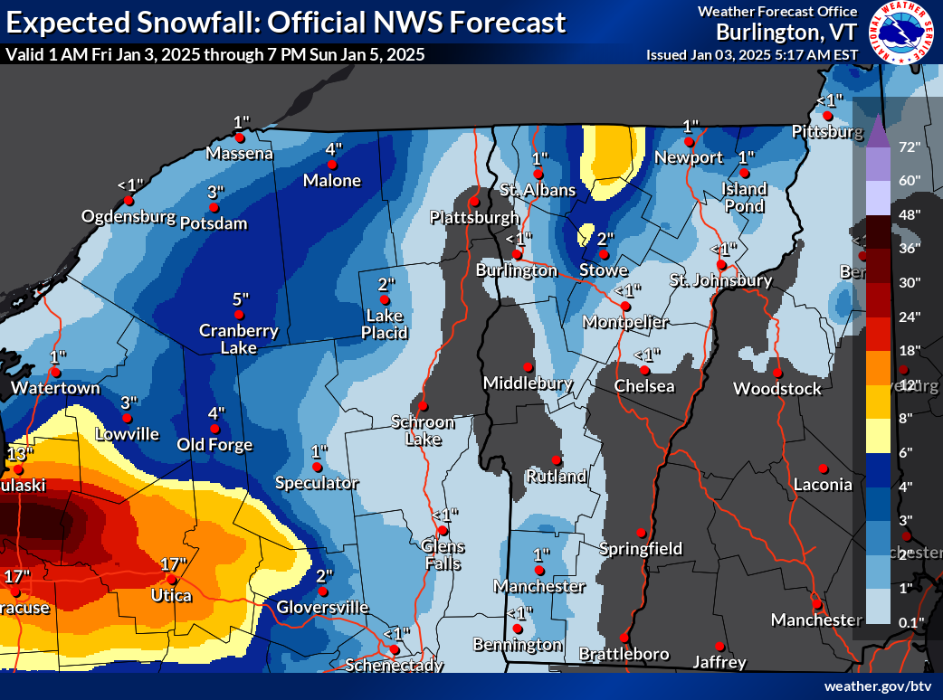
Not much snow this weekend for most of us, but notice the
eight inch expected totals in the northern Green Mountains
of Vermont. Plus the elephant in the room, the expected
three feet of snow downwind of Lake Ontario 
north of Syracuse, New York. 
If you liked the weather in Vermont yesterday, you're going to love the next week or more. Especially if you prefer it much colder than it is now. 

The cold air is coming in, but it's taking its time, despite the rushes of north winds we've been feeling. 

Winds as expected gusted to more than 40 mph Thursday but the temperatures didn't drop quite as quickly as anticipated. 

Burlington stayed above freezing until around 6 p.m. Thursday and most of us were still solidly in the 20s this morning. 

CHILL DEEPENS

 This January is shaping up to be much like 2022. That one also had  warm first couple of days but turned out to be another exception in our past decade or two of warm winter months.

The temperature will keep falling. Starting tomorrow and lasting at least a week, it's going to be persistently cold. Not extremely frigid, but the chill will have staying power. Highs will be in the teens to around 20, with lows in the single numbers to low teens through next Thursday and very likely beyond that. 

WPTZ Chief Meteorologist Tyler Jankowski noted on Facebook Thursday that the forecast for January 4 through 12 is the coldest since 2004. 

 Still, this won't be nearly as cold as some of the notorious Arctic blasts Vermont endured in the 1960s, 1970s and early 1980s. An example: On January 4, 1981, the low temperature in Burlington was minus 27 and the "high" temperature made it all the way up to (check notes) 13 below. 

Only a few places in Vermont were getting snow this 
morning, but traffic cam grab showed it was still
snowing and blowing along Route 58 in Lowell. 
The forecast low for January 4, 2025 is 13 above with a high of 20. So you see the difference. 

The weather maps for the next week look almost the same in our neck of the woods pretty much daily, which is a long time to go with no substantial change.

Every day for the foreseeable future will have that chill, along with lots of clouds and, almost a constant stiff northwest wind. The wind might relax a bit on Monday, but come roaring back afterwards

SNOW CHANCES

The strong, persistent northwest flow from Canada will suppress a pretty strong winter storm far to our south Sunday and Monday. That storm will eventually head way out to sea, then move north, intensify and stall near Labrador next week, keeping the cold winds over us going. 

Our only snow chances will come from moisture wrapping around that storm, and weak little disturbances riding that air flow from the northwest. I also think we might be getting a little moisture from Hudson Bay, which is usually frozen by now.   But there's still some open water up there, so that is probably adding a few extra snowflakes to the mix.

With the current weather pattern, Hudson Bay should finish freezing up soon, though. 

A strong lake effect snow band Thursday with some incredible staying power came off of Lake Ontario well south of Watertown, and held together pretty well as it clipped the southwest corner in Vermont. Its staying power extended all the way to and off the coastline of Rhode Island in the form of scattered snow showers. 

Traffic cam grab along high elevation Route 17 in Buels Gore
shows sun breaking through after fresh snow. Unsure
if that stuff that looks like steam in the background is
blowing snow or snow making at nearby ski areas.

Those lake effect snows are expected to dump up to three feet of snow mostly north of Syracuse, New York through the weekend. The snows from Lake Ontario will probably continue to reach parts of Vermont as light snow showers through the weekend, too. 

This is all good news for snow lovers in the mountains, but it means valleys will continue to see very little of it.

It will be interesting to get updates today on how much snow fell in the northern Green Mountains since yesterday

As of midday Thursday, 11.5 inches of snow had been reported at a 3,000 foot elevation in Underhill, and at another high elevation in Belvedere Center, with 10 inches in Braintree.

Even the southern Green Mountains got into the act with nine inches in Ludlow and eight inches in East Wallingford.

The snow in Vermont looks like it will keep piling up slowly in the mountains and mostly avoiding the valleys. 

The northern Greens can expect locally up to eight inches of additional snow between now and Sunday. More snow will surely fall up in the mountains much of next week.

In the valleys, nothing more than flurries and bursts of light snow. Eventually, even in the Champlain Valley, I imagine there we'd end up with a thin covering of snow, but nothing spectacular.  

Unlike the wild storminess of early January last year, the first half of January, 2025 is looking rather quiet and cold. 

Tuesday, December 31, 2024

New Years Eve Storm Update: Ski Areas To Get Their Snow Back, Valleys, Not So Much

Looked like spring in my St. Albans, Vermont back yard
this afternoon, but changes are coming very soon that
will put us solidly back into winter. 
This year will end up being the warmest on record, as measured in Burlington, so it was fitting that New Year's Eve was so warm. 

(I'll have much more on our warm 2024 in a post tomorrow).

We've got a new year coming in, so we have a new weather regime coming in.  Expect lots of cold weather for much of January, starting within a couple days. 

In terms of snow, it still looks like valleys will be missing out, while the Green Mountains will get very, very white. 

I figure an evening update is due since people will be traveling for the holiday. The forecast since this morning hasn't changed too much, though. 

For those out celebrating tonight, it looks pretty safe, at least in terms of weather. Rain will be spreading in overnight, but might  hold off until after midnight, especially in northern Vermont. The highest elevations might see some snow, but most of us will start off with rain. 

NEW YEARS DAY

If you remember what Thanksgiving was like, New Years Day will be pretty similar in Vermont. Snow will gradually work downhill from the highest elevations, gradually changing the rain to snowflakes until valley floors start seeing the snow, probably in the late afternoon.

Slippery, unpleasant driving conditions will gradually spread over more and more Vermont roads as the day wears on.  You might not want to get up early on New Year's Day, but the best travel weather will be in the morning, when most of us will still be raining. 

It won't amount to much in the valleys, as the snow should tend to taper off for a time in the evening. But overnight and on Thursday, some of us get a nice, big snowstorm.

WEDNESDAY NIGHT/THURSDAY

Our storm still looks like it'll slow down as it moves across Maine and into Quebec Wednesday night and Thursday. It's setting us up for a classic upslope snowstorm in the Adirondacks and especially the central and northern Green Mountains. 

In the Champlain Valley, especially close to the lake, it won't snow much at all. Flurries, basically. Same is true for the Connecticut River Valley, especially south of about Wells River.

The Green Mountains will get plastered, with generally more snow the further you head north. Almost the entire ridge line of the Green Mountains should get at least eight inches of snow, with a foot or more in  many northern Vermont mountains. The Jay Cloud will work overtime, and I'm still expecting up to two feet of new snow up there by Friday. 

It's also going to be really windy everywhere later Wednesday night and Thursday.  Many of us will see gusts to at least 40 mph. Some areas along the eastern slopes of the Green Mountains could see gusts to 50 mph. 

That could lead to isolated power outages. The blowing snow in the heavy snow zones will be absolutely brutal.  Expect some whiteout conditions along roads in the Green Mountains. 

You might be tempted to go up to the ski resorts Thursday for a powder day. Just be warned, it probably will be tough to get there, even if the valley highways aren't bad at all. I also suspect some ski areas might have some wind holds on the lifts. I also think back country skiers might worry about an avalanche risk on steep slopes, too. 

Record Warmth To Vermont Winter Storm As We Head Into The New Year

Big contrasts in snowfall expected with upcoming storm
Less than an inch in lowest valleys far west and far east
in Vermont, while Jay Peak could get two feet. 
It's toasty out there again this morning, as we get one last day of our end of 2024 heat wave. 

We won't have any record highs again today, but we never did get below freezing last night and many of us will be well into the 40s this afternoon. 

Burlington was the big heat winner with this warm spell. We already told you about the record high of 61 on Sunday, set at around 11 that night.

The city also managed to reach 60 degrees Monday, breaking the record high of 58 for the date set in 2022. 

Other high temperatures around the region Monday included 58 in Bennington and Highgate, 57 across the pond in Plattsburgh, 53 in Springfield, and 51 in Montpelier 

The thaw gave Montpelier a bit of a scare yesterday.  An ice jam formed in town, making the Winooski River rise rapidly in Montpelier. The city is still spooked by devastating floods in recent decades, including a 1992 ice jam flood.

In this case, city officials went to work, breaking up the jam with a backhoe and spraying warm, treated effluent onto the ice jam to make it melt. It worked, the jam quickly broke up, and water receded without every quite making it to flood stage. 

NEW STORM

That oft-mentioned New Years Day storm coming in is going to cause some pretty wildly different conditions in Vermont. We're going to have some big time snow winners and losers here. 

By the end of the week, some of the lower valleys of far western and far eastern Vermont will see barely an inch of new snow, if that.  Meanwhile, the northern and central Green Mountains are in for at least a foot of snow.  I wouldn't be the least bit surprised if the Jay Peak cloud over-performs and dumps two feet of snow on that ski area near the Canadian border.

The storm causing all this is pretty dynamic, judging from the very low, but not zero chance of tornadoes today oddly north in parts of Ohio, West Virginia, Maryland and Delaware.

As I mentioned yesterday, the storm is taking the perfect path to dump at least several inches of snow all over Vermont. Too bad there's not enough cold air for snow. The valleys should see mostly rain overnight and New Year's Day, at least for the first half of the storm. 

There is the slightest chance of a New Year's miracle which would chill the air enough to produce snow even in the valleys, but I'm not holding my breath on that one. 

Once the storm gets to eastern New England, it will really start to crank up, then move northward into eastern Quebec and pretty much stall for a couple days. 

That will set up a strong, cold, wet northwest air flow that will last from Wednesday night to at least Friday. It's a classic setup to dump tons and TONS of snow on the central and northern Green Mountains while people in the Champlain and Connecticut River valleys wonder what all the fuss is about. 

The National Weather Service office in South Burlington has posted a winter storm watch for Franklin, Orleans, Lamoille and Washington counties in Vermont, and also the spine of the Green Mountains all the way to south of Killington. 

Winter storm watches are also up for the Adirondacks and in western New York, where the lake effect blasts are set to start again. 

The snow contrasts here in Vermont will be striking.  In Franklin County alone, I'll be surprised if St. Albans Bay gets as much as 1.5 inches. At my place on a high spot on the eastern part of St. Albans, I'm probably in for four or five inches. 

Head up to eastern Franklin County toward Bakersfield, Richford and Montgomery, we're probably talking more than a foot. Maybe even a foot and a half in a couple high spots.

We're also going to see some screaming northwest winds with this, with gusts over 40 mph, so we'll find plenty of blowing and drifting snow, especially where there's a lot of it. 

Plan on travel trouble in high elevations Wednesday, in most of the state Wednesday night, and in the northern and central Green Mountains Thursday and probably Friday.  

Once temperatures fall below freezing later Wednesday, they'll stay there for a long, long time.  Quite possibly until at least mid-month, so any snow that does fall will stick around for awhile. 

Tuesday, December 3, 2024

Snow Gods Are Embracing Vermont Mountains, Ignoring Champlain Valley. But Unexpected Warm Hints On Distant Horizon?

The midweek clipper storm should once again create
only lighter snows in the Champlain and lower
Connecticut River valleys, but the mountains
could easily get more than six inches once again.
 Vermont's Champlain Valley always receives much less snow than the mountains during the winter. 

The moisture skips over the low elevations near the lake and smacks into the Adirondack and Green Mountains instead. Or, the Champlain Valley gets rain while the folks at the ski areas serenely play in the white fluff. 

The contrast over the past several days, though, has been even more extreme than usual.  

Through midnight last night, Burlington has gotten a grand total of 0.2 inches of snow since Thanksgiving. Yep, barely a quarter inch.  

Meanwhile, the snow depth atop Mount Mansfield has gone from 6 inches last Wednesday to 18 inches on Monday.  And Jay Peak has had 30 inches of snow dumped on it since Thanksgiving, and at last report, it was still snowing up there. 

The ski areas are clearly off to a good start after a troublingly dry, warm late autumn.

This trend of mountain dumps and valley "meh" for snow will continue for a few days. 

A weak little weather system overnight and today is producing more mountain snow showers, adding a couple inches of fluff to the mountains while the Champlain Valley barely gets some flurries 

Clipper Storm To Hit

Next up is that well-anticipated strong Alberta clipper we've been watching. It'll come in Wednesday and Thursday with snow for everyone, including the Champlain Valley. 

But the valley should only see one to three inches out of this thing, while the mountains once again see a long-duration snowfall running from Wednesday afternoon to at least Friday morning. 

I wouldn't be at all surprised to see some of Vermont's mountains to see more than eight inches of snow out of this. The lake effect snow machine will get cranking in western New York again with this system, so they'll get buried further. Some of that moisture will make its way to the Green Mountains ,

The core of the lake effect will aim down New York's Mohawk Valley and eventually smack into the southern Green Mountains in Bennington County. That's where the most snow might fall, and a winter storm watch is up for that area. Areas up toward Searsburg, Readsboro and Woodford could see six to as much as a foot of snow out of this.  

By the way, Thursday could be a nasty travel day region wide, as the the storminess will take the form of locally heavy snow showers or squalls, along with gusty winds that would blow the snow around. 

Surprises In Long Range?

We might have a classic example coming up of why long range forecasts can be tricky. It appeared just the other day that this December might turn out to be one of the coldest in recent years. 

A sudden shift in the longer range forecasts for
mid month from frigid in the Northeast to leaning
warm nationwide suggests we're in for highly
variable weather later in December. I'm guessing
some storminess and swings from cold to warm 
to cold to warm, etc 

The forecasts for frigid weather Friday and through the weekend are still in force. 

 But some of those long range forecasts for the middle of the month are now starting to lean toward perhaps a little warmer and a little wetter than average, rather than frigid and dry. 

There's no guarantees here. The forecast could always revert back to cold again.  There's even more uncertainty than usual in the predictions for beyond a week from now.

Winters in the Northeast are always variable, with wide swings in temperature and storminess. 

We might be looking at wider swings between cold and warm later this month, and perhaps the winter as a whole.  It might get kinda stormy, too, so hang on to your hats if that's the case. 

Friday, November 22, 2024

Northeast Storm Update: Some Beneficial Rains Continue, Some Areas Surprisingly Snowy.

A little light rain falls on a very low Lake Champlain 
Thursday at St. Albans, Bay, Vermont. The lake is
very low due to our long, arid autumn.
 Needed precipitation was still falling in the Northeastern U.S, including here in Vermont, early today where modest, but still beneficial amounts of rain had fallen. 

Overall, the only surprising thing about this storm so far is how much snow is falling in some areas - again, just not here in Vermont. 

Though a little bit of the white is coming to the Green Mountain State soon.  More on that in a minute.

Snow fell Thursday as far west as Chicago, where 2.9 inches snarled traffic as this was the first substantial snowfall of their winter season.

A bonafide, pretty substantial winter snowstorm is  hitting parts of northeast Pennsylvania, especially the Poconos, southwestern New York and the Catskills in that state.

The core of the storm's coldest air has been in that region, which is why they're getting so much snow. The highest elevations of the Poconos can expect up to 16 inches of snow by the time this is done. It's been snowing there since yesterday. 

The higher peaks in the Catskills might see six to 12 inches by late tonight. 

Already, Leondardsville and Coventry, New York, in high spots northeast of Binghamton have reported 11 inches of new snow. Tomkinsville, Pennsylvania in the Poconos has gotten 10 inches. And it was still snowing there early this morning.  

It's even gotten into New Jersey. You might have heard about the long lasting, big wildfire on the northwest New Jersey/southwest New York border that had been burning for two weeks could see one to four inches of snow. 

Vermont ski areas can only look longingly at that snow. But the good news is, they'll finally get at least a little.

VERMONT UPDATE

As expected, round one of this storm dumped some decent rains in southern Vermont but not a whole lot in the north. The Northeast Kingdom was especially dry. For example, through early this morning, I don't think it even rained up in Newport, and if it did, it was only a few hundreds of an inch. 

As of a couple hours before dawn, Montpelier managed to pick up 0.21 inches, and Burlington 0.3 inches. Southern Vermont had between a half and two thirds of an inch. 

The map you'll see frequently in the coming months: The
National Weather Service snowfall prediction map.
This one, issued early this morning, shows much of
Vermont getting a bit of snow this weekend, but
any real accumulations would be limited to
high elevations. Click on the map to make it
bigger and easier to see.

If forecasts for the next 48 hours come true, another half inch of rain and/or melted snow is on the way. And yes, I said snow. But don't expect a huge powder day just yet. 

Patches of light rain were still moving east to west across Vermont early this morning. Some of that light rain is finally reaching the Northeast Kingdom.

But that should taper off for everybody in the Green Mountain State this afternoon as an area of dry air gets caught up in the Northeast U.S. storminess and passes through. 

This afternoon could actually be fairly nice, with breaks of sun and temperatures sneaking up to near 50 in the warmer valleys.  We should still have a breezy east wind, though.

Round 2

We're still expected Round 2 in the precipitation overnight and early Saturday and the forecast has actually trended a bit snowier. Most of us aren't in for a winter wonderland just yet, but many of us could see a coating of snow on the ground by Saturday morning. 

As I noted yesterday, a second storm will form well offshore of New England and the curl northwestward into the Gulf of Maine.

That will throw more precipitation westward into Vermont later tonight. There's still question marks as to how much rain and/or snow we we'll see, but the early guess is very roughly a half inch of precipitation, give or take.

Colder air should move in aloft, changing the rain to snow late tonight and early Saturday in many spots. Chances are some wet snowflakes will make it all the way down into the Champlain Valley. 

A lot of places at or above perhaps 800 feet in elevation have a decent shot of seeing a slushy coating to an inch or two. Mountain summits could see a few inches. Beware if you're planning on driving through higher elevations late tonight and early Saturday. Things could get slick in spots. 

As the storminess pulls away Saturday afternoon, we transition into class late November blustery weather 

That means plenty of rain and snow showers, through the rest of the weekend, especially in the mountains and western slopes. Additional snow accumulation will be slim to none in the valleys, but the ski areas could pick up a few inches.  Cold northwest winds could gust past 30 mph both Saturday and Sunday.

A weaker storm should spread some more light rain across the region later Monday into Tuesday. 

Then, winter hits.  By Wednesday and beyond, we'll see daily high temperatures barely making it past the freezing mark in the valleys and staying subfreezing in the mountains. There's uncertain signs of some accumulating snow later in the upcoming week, but we don't know for sure whether that will happen or not. 

 But chances are better than even that if any precipitation comes into Vermont after next Wednesday and  for many days afterward, that precipitation would probably be snow. 

Wednesday, October 16, 2024

Pretty Impressive Snows On Vermont Mountain Peaks, Frost/Freeze Up Next

A traffic camera caught a motorist making their way
through a winter wonderland at around 7:15 this
morning along Route 242 near Westfield, Vermont.
While most of Vermont dealt with cold rain showers and maybe a few wet snowflakes overnight, the mountain summits really piled up the snow.  

SNOWFALL

I don't have too many specific reports yet, but the National Weather Service estimates a good six to nine inches of fresh summit atop peaks like Mount Mansfield and Jay. 

The stake near the top of Mount Mansfield had an accumulation of four inches before a round of occasionally heavy snow showers rolled through last evening. Video showed a very heavy snow squall amid fall foliage at the Bolton Valley Ski Area last night.  

Motorists traveling through high elevation roads like Sherburne Pass along Route 4 near Killington, Route 17 in Buels Gore and Routes 242 and 105 near Westfield and Jay Peak encountered winter driving conditions at times overnight. 

The snow had pretty much melted off those roads as of 8 a.m., so I don't anticipate travel trouble. 

Aside from a few more mountain snow flurries and valley sprinkles, the precipitation is pretty much done. It will remain mostly to completely cloudy north through the day. Some sun will break out south, but it will remain chilly.  

Most places will stay in the 40s, although a few spot 50 degree readings might show up in so-called "warmer" valleys.  That sets us up for probably the end of a prolonged growing season tonight. 

Still, today and tomorrow look like great days for some spoilage viewing, especially the first half of Thursday, when sunshine will light up the mountain snow before beginning to melt it.

FROST/FREEZE

Virtually all of Vermont will be near or below freezing overnight and early Thursday except maybe right near Lake Champlain. 

Despite some still-healthy outdoor plants in most of Vermont, you won't see any frost or freeze warnings in areas outside the Champlain Valley and valleys in the southern parts of the state.

That's because the National Weather Service doesn't issue frost and freeze advisories in areas where the growing season should have ended by now. For many, this first of the season upcoming cold night is coming quite a bit later in the autumn than usual. 

So, places like Montpelier, St. Johnsbury, Morrisville, Stowe and everywhere else in northern Vermont will get below freezing tonight without those advisories.l 

A frost advisory IS in effect in the Champlain Valley as most places there should get pretty close to 32 degrees. Remember, you can get a frost if temperatures officially stay just above freezing.  On calm, clear nights, like what we anticipate the early morning hours of Thursday to be like, temperatures are usually measured five feet off the ground. It might be 33 or 34 at the thermometer, but at your feet, frost is forming on the grass.

In Rutland County, a freeze warning is up because there, temperatures are forecast to dip below 32 degrees. 

THE WARMUP

We are still anticipating a warm up starting a little bit Thursday afternoon and really hitting in earnest starting Friday. It's dry air, so nights will still be chilly and potentially frosty through Friday night and Saturday night. 

Days will warm up nicely into the 60s. By early next week, some low 70s seem like they will pop up. Indian Summer indeed.  It's all being caused by one big honking huge high pressure system that is initially bringing us the cold air but will move a little east and pull up some balmy air from the southwest by the weekend. 

This high pressure system will also bring us plenty of clear skies. During this time, it'll be worth it to take a look at the western sky at twilight, a little after sunset to catch a glimpse of comet Tsuchinshan-ATLAS, which should be visible for the next week or two in the evenings when it's not cloudy.  

Unfortunately we missed the best view of the comet because during these recent cloudy days, the moon didn't interfere with the view. A waxing moon in the coming days might wash out the light of the come some, making it a little harder to see.

The warm air is beginning to look like it might not last as long as originally anticipated, with a new cold front possible by Wednesday, But at least at this point, the air behind that front doesn't look super cold, so it will still be pretty nice. 

Pretty much no rain is in the forecast until at least Wednesday. So far, it looks like if it does end up raining with that anticipated old front next week, it won't amount to much at all.