Showing posts with label lake effect. Show all posts

Monday, January 5, 2026

Impressive Lake Champlain Effect Snowstorm In Small Area Sunday, More Active Weather Area-Wide This Week

National Weather Service snow prediction map taking us
through a small 1 to 3 inch snowfall later today combined
with a slightly larger but not huge storm Tuesday night.
Some mix is possible toward the end of the
second storm late Tuesday night and early Wednesday. 
Click on the map to make it bigger and easier to read.
A surprise snowstorm blanketed a small area near the southern end of Lake Champlain Sunday. 

It was one of the most impressive lake effect snowfalls off of Lake Champlain I've ever seen.

Most of the snow fell on the New York side of the lake, but some of it clipped the immediate lakeshore on the Vermont side.

Snowfall totals included 9 inches in Port Henry, New York, 7 inches in Willsboro and Crown Point, and 6 inches in Mineville and Moriah Center, New York and Chimney Point in West Addison, Vermont. 

Light winds, just east of due north, flowed down the length of Lake Champlain all day. The direction of the wind aimed the snow at the southern end of the lake on the New York side, but also clipped the point of land that juts into the lake at West Addison, Vermont.

Since the winds weren't very strong, they had plenty of time to gather moisture off unfrozen sections of the lake.  The lake narrows as you head south and hills on either side of the lake become closer together. That, and some light west winds coming over the Adirondacks, helped the air flow converge, or squeeze together. 

When that happens, the air has nowhere to go but up. Rising air cools, and that makes the moisture in the air condense. That condensed moisture fell as snow.  It was a fluffy stuff, so it was able to accumulate pretty deeply. 

WHAT'S NEXT

The big picture is all of us, not just a small piece of the southern Champlain Valley are going to get some snow this week. The bad news is we're going to get some other stuff, too. We have three or four quick storms to talk about. None of them are huge, but each will affect your life to some degree. 

Storm #1

After a morning that brought us temperatures near or below for, it's clouding up pretty fast. A tiny storm is going to go right over the top of us this afternoon and night. Since the system is so small, this will be a quickie. It'll start snowing by around mid afternoon and finish up before midnight.  I'm calling this "Storm #1 but that's being generous. It's a minor thing. 

Most of us should get between 1.5 and 2.5 inches of snow, with maybe a little less in the Northeast Kingdom, where the air might be a little drier. It'll stay cold with this little event. High temperatures much like yesterday, will stay in the teens. 

Today's snow, although not amounting to much, should be enough to make the drive home from work this afternoon and evening a little slick and annoying. Plan on taking it slow. 

Tomorrow, ahead of the next storm, will feel like a glorious heat wave. Highs should soar all the way to near 30, which is close to normal for this time of year. 

The next storm hits tomorrow night. It will be a little bigger than today's squirt of snow, but it won't be enormous. 

It'll come out of the southeastern Great Lakes tomorrow evening and head toward northern Vermont, where it will begin to fade. A new storm will form near Maine and become the predominate one. 

How and when this little transfer of power from the original storm to the new one in Maine will determine how much of this will be snow and how much will be a mix.

As it stands now, the transfer will keep us in Vermont with mostly snow. Especially north. Current projections have us getting two to six inches of snow, with some mixed precipitation toward the end of the storm late Tuesday night and early Wednesday. 

Southern Vermont should get less snow, maybe one to two inches out of this storm, and more freezing rain and sleet than the north. This will mess up the roads, but be not nearly enough to wreck trees and power lines like the last bout of freezing rain on December 29 did.

#Storms #3 and #4

For some of us, our well advertised January thaw wills start marginally on Wednesday, as highs get into the mid 30s. Thursday will be mild and quiet, with highs in the 35 to 42 degree range. 

Then we get the next system. I'm calling this batch Storm #3 and Storm #4 because current projections have it coming in two waves. At least some computer models have one storm going by to our west Friday and another close on its heels Saturday. 

Since both storms will go by to our west, these storms will be almost exclusively rain. At this point, I don't think either of these systems will produce enough rain and thawing to create a flood concern. But we'll keep an eye on these as they get closer nevertheless. 

Starting next Sunday night and Monday , we will get back to our regularly scheduled winter. At first, the  the cold won't be too intense. It'll basically be about average early next week. But signs point to gradually deepening cold as we head further into the month.  

Friday, November 28, 2025

Back To Winter In Vermont As Several Snow Chances (With Rain Thrown In) Coming Up

National Weather Service radar from around 9 this
morning. You can see a band of snow moving
into southern Vermont. That's lake effect,
originating all the way over at Lake Huron.
Bands of snow curving northeastward in
northern Vermont is a sign that a new
disturbance is starting to suppress the lake
effect southward. The disturbance will
generate new snow showers this afternoon. 
The tail ends of big lake effect snows from Lake Ontario made it all the way to Vermont overnight and this morning, introducing winter back to the Green Mountain State after a short break. 

One snow band put down a dusting of snow in northern Vermont last night, with maybe a couple inches in the mountains. It looks like Jay Peak managed to collect at least two or three inches of snow overnight.

A more impressive snow band was moving into parts of southern Vermont this morning. 

It actually originated all the way over in Lake Huron, got new energy crossing Lake Ontario, and moved all the way across New York through Vermont.

 It looked like that narrow band was somewhere near Manchester as of 9 a.m.  Maybe ski areas like Bromley are getting a little bonus snow this morning. 

That snow band then to some extent reached across southern New Hampshire all the way to southwestern Maine. That is an impressively long trip for a lake effect from Lake Huron! 

The wind is shifting, so Vermont will lose the lake effect snows later this morning. You could see on radar the remnants of one streak of snow over northern Vermont  curving northeastward. They're responding to another weather disturbance diving in.  That will keep the snow showers going all day today. 

Some of this afternoon's  snow showers, especially over the mountains and in eastern Vermont north of White River Junction could be briefly heavy, especially inland from the Connecticut River.  

Most of us will only see a dusting to an inch of snow. As always, expect a little more than that in the Green Mountains. 

NEXT STORM

Next up is kind of a mixed, and not particularly memorably little storm set to come through Sunday and early Monday. It'll probably be a snow to rain kind of thing, with not much accumulation. Not all that much rain, either to be honest.  Rain and melted snow from this next hiccup would only amount to a quarter inch or maybe even less. 

Snow accumulation for most of us would again be near an inch. 

THE NEXT, NEXT STORM

The next storm in the series looks like it could get interesting. If we get this storm, it would come through Tuesday and into Wednesday. 

It would be a nor'easter, and if the path of this thing is just right, we could be looking at a pretty good sized snowstorm. At least for some of us. It's only Friday, so we don't have a good bead yet on how close to the coast it would come. 

There's the potential that at least part of Vermont cold get a good dump of snow.  We don't know for sure yet which part of the state would get a lot of snow. Maybe none of us will get much. 

Stay tuned! 

Friday, November 14, 2025

Cold, Cloudy, Often Snowy Vermont November Revealing Some Quirks

Traffic cam image from yesterday afternoon shows
a lot of snow falling along Route 105 in Jay, Vermont.
If you think it's been a cold November in Vermont so far,  you're absolutely right. 

Through yesterday, the month is running 2.9 degrees cooler than normal, as measured in Burlington. 

Remember, that's the "new normal," based on the average of Novembers from 1990 to 2020. By then, climate change had really started taking hold. 

Average Novembers used to be colder than they are now. This month isn't coming anywhere near close to becoming among the chilliest on record. But we're surely noticing how wintry this month has been so far. 

Still, this chill is a departure from most recent Novembers, though 2019 was notably cold. On November 13 of that year, the temperature in Burlington fell to 9 degrees above zero, the coldest for so early in the season.

What's been notable this month so far are the comparatively warm nights. The coldest it's gotten in Burlington so far this month is 27 degrees. It usually gets at least that cold by Halloween. A spoiler, though: The forecast low in Burlington tonight is 24 degrees.

That's still not especially chilly for this time of year. 

SNOWY MOUNTAINS

It really, really snowed in the central and northern Green Mountains yesterday. I could tell something was happening up there from my perch here in St. Albans. It snowed all day here. Not hard, and it often mixed with rain, so our accumulation was just 0.2 inches. 

But just go a little higher in elevation than where I am at 650 or so feet, and things really started to pop with the snow. 

The snow depth atop Mount Mansfield by late yesterday afternoon was 22 inches. Since records started up there in 1954, only 1976 and 1990 had deeper snow at this date. 

I don't yet have any specific reports of snow accumulation from just yesterday, but I'm dying to find out how much Jay Peak got.

The early deep snow in the mountains doesn't necessarily mean we'll have a snowy winter. 

The winter of 1976-77 was a little snowier than average in Vermont, but had less snow than all the other winters in the particularly snowy 1970s winters.

The winter of 1990-91 in Burlington had just 42.5 inches of snow, far below the normal of 78 inches. 

FORECAST

The moist, cold northwest flow has dried up a little since yesterday, though we will see some scattered snow showers today. Again. Now that the snow has started, it doesn't seem to want to end. At least not everywhere. 

Most of whatever snow we get today will be in the mountains. 

However, the National Weather Service in South Burlington has flagged one interesting potential today. There might be a band of lake effect snow setting up off of Lake Champlain. It it happens, you might see it snowing it places like Charlotte, Ferrisburgh, Monkton and Hinesburg, that area. The snow band might jump all the way over the mountains to places around Rochester and Granville. 

Those places might get an inch of snow, maybe a tad more. 

When the Lake Champlain temperature is as warm as it is now, lake effect snows can drop a few inches of snow in the central and southern Champlain Valley. 

As mentioned, tonight could be the coldest night of the year so far, but that's not saying much. The reason: Skies might finally briefly, partially clear.  Clearer skies can mean colder nighttime temperatures. 

NWS South Burlington also says patchy freezing fog could develop toward morning. That'll leave a pretty frost on the trees, but can also create icy spots on roads. Especially on bridges and overpasses. Take care tomorrow morning if you're driving anywhere. 

Saturday 

Speaking of ice, we're still watching a storm due this weekend that threatens us with a nasty mix of snow, ice and rain. 

The timing of this storm has moved up a little, so now it will start to affect us tomorrow afternoon. It'll be cold enough so that it'll start as a nasty mix of snow, sleet, freezing rain and rain. 

It still looks like it'll be warm enough in the Champlain Valley so that most of this will probably be a cold rain. But along and east of the Green Mountains, freezing rain looks like it will hang tough. It won't be enough to wreck the trees, but certainly enough to make the roads very, very iffy. 

Keep that in mind if you're driving anywhere Saturday night, especially outside the Champlain Valley. 

There's still some questions about how this storm will sugar out. It'll probably move eastward near the Canadian border Saturday night, while a new storm gets going on the Maine coast. 

The interaction and exact paths of these storms will determine how much rain, mix and snow we get. 

The storm might be another installment, albeit a small one for continued drought relief. Right now, the forecast calls for roughly a half inch of rain, and melted snow and melted ice. 

Sunday and Beyond

The storminess will start to pass by us on Sunday and strengthen as it moves slowly into the Canadian Maritimes. 

That means another spell of cold northwest winds, lots of clouds, and snow showers. Those snow showers will once again mostly hit the central and northern Green Mountains. There could be a few more inches up there. 

Monday will be particularly windy and cold, but the chilly air will stand strong most of the week. It does look like it might finally warm up a bit toward the end of next week. 

The overall weather pattern looks active, with frequent chances of precipitation probably through to the end of the month.  

Tuesday, November 11, 2025

Not Just Vermont: Arctic Blast Spreads Snow, Deep Chill Across Eastern Half of Nation

A heavy blanket of snow this morning in St. Albans,
Vermont. It was part of a huge cold and snowy
spell over the eastern U.S. Northern areas had zones
of heavy snow, while the Southeastern U.S.
reported record lows. 
I'm looking out the window today at nearly nine inches of snow outside, which is really something for November 11 in Vermont's Champlain Valley. 

And it's still snowing a little. 

I guess I can take comfort in the fact I have company. A remarkable blast of Arctic air - with snow in many places - has overtaken most of the eastern United States. 

Lake effect snows were the big story in the Midwest Monday. Chicago managed to avoid the worst of the lake effect snow bands that threatened the Windy City with up to a foot of snow. 

The worst of the lake effect snows hit north, south and east of Chicago. The city itself managed only about two or three inches of snow, while 3.5 inches of snow. Some places, like Momence and Cedar Lake, Illinois, got a foot of snow. 

Where it did snow it seemed to come all at once.  Video by Live Storms Media showed whiteout conditions in and around Gary, Indiana. 

Thing were so wild on Lake Michigan that there were waterspouts, or maybe more accurately, snowspouts spinning away out there in the turbulent, cold air over the water. 

The lake effect snows spread eastward during the day Monday. 

Meanwhile, a lake effect snow warning was issued for areas south of Buffalo through tomorrow morning. Some areas could get nearly a foot of snow. Parts of northwest Pennsylvania and northeast Ohio were also getting lake effect snows. 

Snow fell pretty far south, too. Stone Mountain, Georgia and Nashville, Tennessee were among the many southern locations that saw snow flurries. 

SOUTHERN FREEZE

Freeze warnings this week encompassed a huge swath from eastern Texas to southeast Virginia.  

The freeze warnings extended as far south as Brooksville, Florida, which is about 50 miles north of Tampa. 

It was a record 28 degrees in Jacksonville, Florida this morning, the earliest in the season its' been this cold since at least 1976. Charleston, South Carolina was also the coldest since 1976 with a low of 29 degrees. Savannah, Georgia reached 28 degrees. 

Other record lows in Florida this morning included 31 in Pensacola, 36 in Orlando, 35 in St. Augustine, 38 in Melbourne, 45 in Naples, 42 in Fort Myers and 40 in Sarasota.  

Overall, more than 80 record lows were tied or broken this morning, mostly in the southeastern United States. 

Freeze warnings are up again tonight in Florida and southern Georgia.

Ironically, the cold spell may in some weird way be related to climate change. In large swaths of the Arctic, temperatures in recent days have been as much as 30 degrees above normal. It's being cause by something called a Greenland Block. 

The Greenland Block is a large are of high pressure that sometimes sets up over the Arctic. It's a warm air mass, by their standards, anyway. The Block forces the cold air that's usually way up in Canada southward, into the United States. 

The block itself isn't related to climate change, but they're probably boosted by a warmer Earth. We also don't know if climate change makes the Greenland Block happen more frequently than it once did, or is this just some natural thing that happens from time to time with or without climate change. 

In any event, the Greenland Block is re-orienting itself by pressing a little more westward into Canada; This will help shut off a lot of the cold air coming from central Canada, though New England will stay on the cool side for quite awhile yet. 

But for the rest of the East and Southeast, this was just a foretaste of winter. Not the actual start of the season. 


Friday, January 10, 2025

Banner Lake Effect Snow Winter, By Vermont Standards, Anyway

Finally looking like winter in St. Albans, Vermont after
 a week of light snow and flurries. And notice in this 
photo taken this morning there's finally a hint of 
clearing skies in the distance. Some sun is 
possible today for a change. 
 Lake Champlain between Vermont and New York is considered two small to be a source of lake effect snowstorms, like you see out by the Great Lakes in cities like Buffalo, Watertown and Erie. 

Oh, sure you get a little lake effect from Champlain, so goes the thinking, but nothing substantial.

Except for this winter. 

For the third time the season the Champlain Valley of Vermont on Thursday saw yet another lake effect snowfall courtesy of the still mostly unfrozen Lake Champlain.

Not all the snow came off the lake, of course.  Some of it was just that moist north wind that has been coming down from Quebec most of this week. 

 But that snow was enhanced as it picked up moisture from the lake and deposited it on places from Colchester, through Burlington and down into Addison County.

The National Weather Service office in South Burlington collected 5.4 inches of new snow yesterday.  That's more than most places in Vermont received. Early Thursday afternoon, while most of Vermont was reporting light snow or no snow falling from the sky at all, Burlington had bursts of heavy snow. 

Essex Junction reported 7.5 inches of new snow. There were several reports of five inches totals from around Chittenden County, including in Colchester, Westford and Underhill. 

The at least partly lake effect snow follows another bout of fluff off of Lake Champlain on January 5 that deposited more than four inches of snow on towns like Shelburne, Huntington and Charlotte. 

Back on December 21, up to 5.7 inches of snow, much of it lake effect off Champlain, whitened the Burlington area.

It's probable that some sections of Chittenden and Addison counties have had more than a foot of snow total this winter just from Lake Champlain. 

Of course, other areas of Vermont received snow yesterday and that had little or nothing to do with lake effect. There were reports of half of foot of additional fluff from some northern Vermont towns.  Up here in St. Albans, we had just over two inches of snow yesterday morning, with four inches so far this week. 

Vermont State Police said the persistent snowfall this week - lake effect or not - resulted in 163 weather-related crashes with 19 injuries. 

After a break in the snow total, a general one to two inches of snow is likely pretty much statewide as a weak system passes through. 

There will be other chances of light snow off and on during next week. It's possible that could include a little more Lake Champlain snow, but that kind of forecasting is hard to tease out now.

We also still don't have any big storms in sight for at least a week.  

Friday, January 3, 2025

Vermont/New England In For A Long, Cold Blustery Week Or More, Mountain Snows Continue

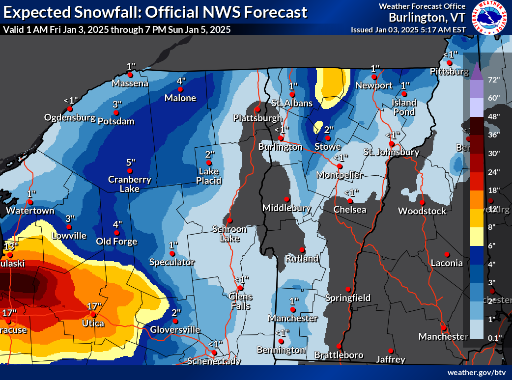
Not much snow this weekend for most of us, but notice the
eight inch expected totals in the northern Green Mountains
of Vermont. Plus the elephant in the room, the expected
three feet of snow downwind of Lake Ontario 
north of Syracuse, New York. 
If you liked the weather in Vermont yesterday, you're going to love the next week or more. Especially if you prefer it much colder than it is now. 

The cold air is coming in, but it's taking its time, despite the rushes of north winds we've been feeling. 

Winds as expected gusted to more than 40 mph Thursday but the temperatures didn't drop quite as quickly as anticipated. 

Burlington stayed above freezing until around 6 p.m. Thursday and most of us were still solidly in the 20s this morning. 

CHILL DEEPENS

 This January is shaping up to be much like 2022. That one also had  warm first couple of days but turned out to be another exception in our past decade or two of warm winter months.

The temperature will keep falling. Starting tomorrow and lasting at least a week, it's going to be persistently cold. Not extremely frigid, but the chill will have staying power. Highs will be in the teens to around 20, with lows in the single numbers to low teens through next Thursday and very likely beyond that. 

WPTZ Chief Meteorologist Tyler Jankowski noted on Facebook Thursday that the forecast for January 4 through 12 is the coldest since 2004. 

 Still, this won't be nearly as cold as some of the notorious Arctic blasts Vermont endured in the 1960s, 1970s and early 1980s. An example: On January 4, 1981, the low temperature in Burlington was minus 27 and the "high" temperature made it all the way up to (check notes) 13 below. 

Only a few places in Vermont were getting snow this 
morning, but traffic cam grab showed it was still
snowing and blowing along Route 58 in Lowell. 
The forecast low for January 4, 2025 is 13 above with a high of 20. So you see the difference. 

The weather maps for the next week look almost the same in our neck of the woods pretty much daily, which is a long time to go with no substantial change.

Every day for the foreseeable future will have that chill, along with lots of clouds and, almost a constant stiff northwest wind. The wind might relax a bit on Monday, but come roaring back afterwards

SNOW CHANCES

The strong, persistent northwest flow from Canada will suppress a pretty strong winter storm far to our south Sunday and Monday. That storm will eventually head way out to sea, then move north, intensify and stall near Labrador next week, keeping the cold winds over us going. 

Our only snow chances will come from moisture wrapping around that storm, and weak little disturbances riding that air flow from the northwest. I also think we might be getting a little moisture from Hudson Bay, which is usually frozen by now.   But there's still some open water up there, so that is probably adding a few extra snowflakes to the mix.

With the current weather pattern, Hudson Bay should finish freezing up soon, though. 

A strong lake effect snow band Thursday with some incredible staying power came off of Lake Ontario well south of Watertown, and held together pretty well as it clipped the southwest corner in Vermont. Its staying power extended all the way to and off the coastline of Rhode Island in the form of scattered snow showers. 

Traffic cam grab along high elevation Route 17 in Buels Gore
shows sun breaking through after fresh snow. Unsure
if that stuff that looks like steam in the background is
blowing snow or snow making at nearby ski areas.

Those lake effect snows are expected to dump up to three feet of snow mostly north of Syracuse, New York through the weekend. The snows from Lake Ontario will probably continue to reach parts of Vermont as light snow showers through the weekend, too. 

This is all good news for snow lovers in the mountains, but it means valleys will continue to see very little of it.

It will be interesting to get updates today on how much snow fell in the northern Green Mountains since yesterday

As of midday Thursday, 11.5 inches of snow had been reported at a 3,000 foot elevation in Underhill, and at another high elevation in Belvedere Center, with 10 inches in Braintree.

Even the southern Green Mountains got into the act with nine inches in Ludlow and eight inches in East Wallingford.

The snow in Vermont looks like it will keep piling up slowly in the mountains and mostly avoiding the valleys. 

The northern Greens can expect locally up to eight inches of additional snow between now and Sunday. More snow will surely fall up in the mountains much of next week.

In the valleys, nothing more than flurries and bursts of light snow. Eventually, even in the Champlain Valley, I imagine there we'd end up with a thin covering of snow, but nothing spectacular.  

Unlike the wild storminess of early January last year, the first half of January, 2025 is looking rather quiet and cold. 

Sunday, December 22, 2024

New Snow Might Keep Us Refrigerated All Week, Even After Intense Weekend Cold Departs

Steam and warmth from Lake Champlain was still
creation clouds over the lake near Burlington this
morning, as this hazecam.net screen grab shows,
but the lake effect snows of yesterday are over. 
Yes, yes, I know, it's nasty cold out there in Vermont and surrounding areas. 

Jackson the Weather dog here in St. Albans really cut short his early morning observations when we went out before dawn today.

  He's not into this type of chill at all. Can't say I blame the little guy. 

Low temperatures this morning were pretty uniform statewide in Vermont this morning.  That tends to happen when there's a steady winds. 

 Burlington was the banana belt town as usual, dipping down to 5 degrees this morning.  Everyone else was pretty much between 5 below and 2 above, even in the valleys of far southern Vermont. 

Wind chills this morning were mostly in the teens below zero.  You'll really want to dress for the weather today, as most of us won't even make it to 10 above, and the north wind will continue to blow steadily. Don't be fooled by the sun when it comes out. The low angle light won't help with the chill at all. 

Yesterday's lake effect snows in the Champlain Valley might well contribute to the end of Burlington's longest continuous stretch of above zero temperatures. Today was the 663rd day in a row that was above zero, as measured at the National Weather Service office in South Burlington. 

Usually, the Champlain Valley receives the least snow in any given winter storm. This time, they got the most, thanks to that lake effect snow Saturday. 

Six inches of snow covered Shelburne, Vermont. In a rare feat, The National Weather Service office in South Burlington was the snowfall winner, with a storm total of 6.3 inches.  

Because the snow cover around Burlington is deeper than what had been forecast, that improves the chances that the record long stretch of temperatures continuously above zero will end.

Deeper snow tends to encourage lower temperatures on clear, calm winter nights. Monday morning could well end the long, long streak of continuously above zero temperatures. 

But it's not a slam dunk.  If any clouds move in off Lake Champlain, or the wind stirs a bit at just the right time, it'll stay above zero in Burlington. The current forecast for Monday morning's low is 1 above. But it honestly could end up at up to five degrees either side of that figure. 

If you're away from the lake, it's pretty much guaranteed you'll be below zero early tomorrow morning.  temperatures will vary early Monday much more than they did this morning. The cold hollows could make it into the mid and upper teens below zero.

CHILLIER OUTLOOK

It's not going to warm up as much or as fast during the upcoming week as originally thought. A quick Alberta Clipper will probably sneak through real quick Monday night and Tuesday, throwing a couple more inches of snow our way. 

Meanwhile, the high pressure that's bringing our weekend nasty chill will park itself over southeastern Quebec much of the week. The air mass will modify, so that temperatures will become seasonable and comfortable - highs in the 20s to low 30s.

But since there won't be much in the way of south winds, and the snow cover will help chill the air near the ground, there won't be any wholesale warmup at least until the end of the week. 

However, it could warm up a lot toward the New Year.  A strange weather pattern is setting up that will roast most of North America, relatively speaking, in oddly balmy air for winter. I'll get into that in an upcoming post. 

Saturday, December 21, 2024

Vermont Lake Effect Snow Develops In Champlain Valley; Up to 6 Inches Snow Possible

National Weather Service radar this morning showed
two lake effect snow bands coming off of Lake 
Champlain. One was hitting an area in and around
Colchester and Milton, while another stronger one
was in southern Chittenden County and 
in Addison County. 
 As mentioned in a post earlier today, it's still snowing a little across Vermont. 

But in the Champlain Valley of Vermont, especially in Addison County and the southern half of Chittenden County, something of a lake effect snowstorm has blossomed this morning. A winter weather advisory has been issued or those two counties. 

Areas along the Route 7 corridor from near the shores of the lake to the western slopes of the Green Mountains in this area can expect a storm total of up to six inches of snow.

There was actually two  snow bands coming off Lake Champlain this morning. One, was coming in from east of Grand Isle into Milton, Colchester and Burlington  

The second, stronger band was focusing on places like Charlotte, Shelburne and Ferrisburgh and nearby areas. 

So far 5.7 inches of snow had fallen at the National Weather Service office in South Burlington,  as of mid-morning and I'd say half or more of that was lake effect. 

These  pales in comparison to some of those epic storms you see off the Great Lakes. But it does show Lake Champlain is capable of creating its own little snowstorms.  Especially after a warm autumn when the contrast between lake and water temperature is great, and there's no ice on the lake.

Drier air moving in this afternoon should weaken and eventually end these snow bands. 

Friday, December 13, 2024

Thursday's Lake Effect Snows Were REALLY Something; Active Weather Pattern To Continue

Screen grab showing intense Lake Ontario snow squalls
blasting downtown Watertown, New York Thursday. 
For the second time in recent weeks, western Pennsylvania and New York were slammed by incredible Great Lakes snow squalls.  

Also for the second time in that period, Vermont got a taste of the action. In both the hard hit areas and in Vermont, this round of snow squalls didn't result in snow as deep as the first time. But this latest bout was more intense.

Here's an example:  As of early Thursday afternoon, Eden, New York, reported 28 inches of snow, but an incredible foot of that slammed down in just two hours.  Eventually, snow piled up to 35 inches in Eden.  

The snow shut down highways near and south of Buffalo, New York and prompted states of emergency.  As is usual in these lake effect cases, snowfall was capricious. The city of Buffalo itself only received 2.4 inches of snow Thursday. Just a few miles south,  several towns reported at least 30 inches of new snow. 

Most of Thursday, like the line of squalls of Lake Erie south Buffalo, the snow band off of Lake Ontario resembled a long finger pointing off the lake into northwestern New York, into Vermont and even beyond at times.

That finger was wagging at us, see-sawing back and forth, northward and southward with the wind. But what was odd was how well organized the band of snow was even when it reached Vermont. Usually, these things are pretty fragmented by the time they get here. 

Early in the day, as dawn broke, by the time it reached Vermont the snow band was aimed east-southeastward, down Interstate 89 toward Montpelier.

National Weather Service radar from Thursday morning 
showing a strong Lake Ontario snow band holding
together remarkably well as it made its way 
into Vermont. 
As the wind backed into the southwest a little bit ahead of a second cold front, the band of snow drifted northward, making it almost to the Canadian border above Franklin County and into southeastern Canada and the northern tip of New Hampshire.

Then the wind gradually shifted into the northwest, sending the band southward again. 

Few spots in Vermont got all that much snow, but it came down really hard for brief periods, reducing visibility on roads which also got slick for short intervals before the sun reappeared. 

Then it moved north, coming into Vermont near the Canadian border around noon. Then the band drifted south again as a new cold front came in from the north, pushing the band southward in tandem.

Most places that saw snow from this lake affect band got little snow.  It came down really hard here in St Albans for a short period of time, but we only got about a half inch of new snow. Some higher elevations in northern Vermont did well, however. Greensboro reported 6.4 inches of fresh snow. 

UP NEXT

Saturday is going to be weird, but you won't readily notice it. A high pressure system coming in will be so strong that we'll be close to records in Vermont for the highest air pressure on record for December. 

The record is 1051 mb or 31.03 inches set on Christmas, 1949. We should be close by Saturday, with forecast pressures near 1048 mb or nearly 31 inches on Saturday. 

The Christmas season is high pressure enough, so the good news, is, you just go through your day Saturday, you won't notice much from this meteorological high pressure. It will just produce For those sunshine on Saturday and a very chilly Saturday night.

 This type of high pressure tends to cause clear, calm nights, so some areas will have their first subzero readings of the winter. Especially in cold hollows with snow on the ground.

In Burlington, the temperature hasn't even gotten into the teens yet this early winter, which is very odd, since it routinely gets into the single digits and low teens this time of year. We should finally get that cold Sunday morning, with a forecast low of 8 above.

The high pressure will give way later Sunday, and it's beginning to look like we'll have another somewhat stormy week next week. A minor system to start might give us a little snow or rain later Monday

Then, a somewhat stronger storms look like they'll come through 'Tuesday, with mostly rain again as we warm right back up again.  There won't be nearly as much rain as we had Wednesday, so no flooding issues, but this will be another bummer for winter sports fans.

Another somewhat substantial storm looks like it might (or might not!) come through at the end of next week. But it's too soon to figure out how that one will take shape.


Saturday, December 7, 2024

Great Lakes Snow Collapses Buildings, Will Forecast Rain Make It Worse?

Firefighters and other municipal workers removing snow
from an Erie County, Pennsylvania fire station that
threatened to collapse under the weight of five feet
of snow that fell in the past week. Rain in the 
forecast Monday will add weight to the snow, possibly
triggering new collapses.
The long lake effect snow siege near Lakes Erie and Ontario in parts of Ohio, Pennsylvania and New York are pretty much over as of this afternoon, but more trouble for that zone looms. 

The snow has got to melt at some point, and that process should start Monday. 

That's what's about to cause some new issues. 

So much snow has come down in those lake effect snow zones in Ohio, Pennsylvania and New York that buildings are starting to creak and crumble under the weight. 

Already, the roofs have been coming down. In Ashtabula, Ohio, there were six roof collapse in just a single day after some parts of the city had as much as five feet of snow. So far, no injuries have been reported.

Among the collapses in Ashtabula was a partial roof failure at a high school in the city. 

In Jefferson County, New York, two separate roof collapses destroyed a house and a barn. The barn collapse killed 20 cows. Jefferson County is the area around Watertown, New York. At least a couple businesses suffered roof failures in Erie County, Pennsylvania.  

The lake effect snow machine is shutting down for now as a new weather pattern takes hold. But that new pattern threatens to cause new headaches in these hard hit, snow-buried towns. 

Namely, forecast call for warmer temperatures and rain in the upcoming week. 

At first, the rain will be bad for the snow blasted snowmelt towns near the Great Lakes, as the rain will soak into the deep snow, making it even heavier. That threatens more roof collapses.

Those big piles of snow on the ground will also block storm drains that accept water from rain and melting snow. That means street and basement flooding could easily become an issue in the worst-hit towns. 

Erie, Pennsylvania officials are scrambling to push snow piles away from storm drains and are urging residents to do the same.

In Northeast Ohio, where up to five feet of snow from Lake Erie piled up, residents are being put on alert that if their basements are prone to getting wet, be prepared for a long week. Residents are being told to remove items they can from basements to prevent damage. Water and restoration companies are gearing for a busy few days. 

One saving grace: Early forecasts hint that the heaviest rain this coming week will hit east of the Great Lakes snow belt zones, mainly in New England. But up to an inch of rain could fall on northeast Ohio, northwest Pennsylvania and western New York by Wednesday night. 

Tuesday, December 3, 2024

Snow Gods Are Embracing Vermont Mountains, Ignoring Champlain Valley. But Unexpected Warm Hints On Distant Horizon?

The midweek clipper storm should once again create
only lighter snows in the Champlain and lower
Connecticut River valleys, but the mountains
could easily get more than six inches once again.
 Vermont's Champlain Valley always receives much less snow than the mountains during the winter. 

The moisture skips over the low elevations near the lake and smacks into the Adirondack and Green Mountains instead. Or, the Champlain Valley gets rain while the folks at the ski areas serenely play in the white fluff. 

The contrast over the past several days, though, has been even more extreme than usual.  

Through midnight last night, Burlington has gotten a grand total of 0.2 inches of snow since Thanksgiving. Yep, barely a quarter inch.  

Meanwhile, the snow depth atop Mount Mansfield has gone from 6 inches last Wednesday to 18 inches on Monday.  And Jay Peak has had 30 inches of snow dumped on it since Thanksgiving, and at last report, it was still snowing up there. 

The ski areas are clearly off to a good start after a troublingly dry, warm late autumn.

This trend of mountain dumps and valley "meh" for snow will continue for a few days. 

A weak little weather system overnight and today is producing more mountain snow showers, adding a couple inches of fluff to the mountains while the Champlain Valley barely gets some flurries 

Clipper Storm To Hit

Next up is that well-anticipated strong Alberta clipper we've been watching. It'll come in Wednesday and Thursday with snow for everyone, including the Champlain Valley. 

But the valley should only see one to three inches out of this thing, while the mountains once again see a long-duration snowfall running from Wednesday afternoon to at least Friday morning. 

I wouldn't be at all surprised to see some of Vermont's mountains to see more than eight inches of snow out of this. The lake effect snow machine will get cranking in western New York again with this system, so they'll get buried further. Some of that moisture will make its way to the Green Mountains ,

The core of the lake effect will aim down New York's Mohawk Valley and eventually smack into the southern Green Mountains in Bennington County. That's where the most snow might fall, and a winter storm watch is up for that area. Areas up toward Searsburg, Readsboro and Woodford could see six to as much as a foot of snow out of this.  

By the way, Thursday could be a nasty travel day region wide, as the the storminess will take the form of locally heavy snow showers or squalls, along with gusty winds that would blow the snow around. 

Surprises In Long Range?

We might have a classic example coming up of why long range forecasts can be tricky. It appeared just the other day that this December might turn out to be one of the coldest in recent years. 

A sudden shift in the longer range forecasts for
mid month from frigid in the Northeast to leaning
warm nationwide suggests we're in for highly
variable weather later in December. I'm guessing
some storminess and swings from cold to warm 
to cold to warm, etc 

The forecasts for frigid weather Friday and through the weekend are still in force. 

 But some of those long range forecasts for the middle of the month are now starting to lean toward perhaps a little warmer and a little wetter than average, rather than frigid and dry. 

There's no guarantees here. The forecast could always revert back to cold again.  There's even more uncertainty than usual in the predictions for beyond a week from now.

Winters in the Northeast are always variable, with wide swings in temperature and storminess. 

We might be looking at wider swings between cold and warm later this month, and perhaps the winter as a whole.  It might get kinda stormy, too, so hang on to your hats if that's the case. 

Monday, December 2, 2024

Brace Yourself, Vermont: You're REALLY About To Get Slapped By Winter. Also, Not Just Vermont

 Like I noted in a post Sunday morning, it's been an incredibly warm year in Vermont.

A weather map depicting what forecasters think will
be happening Thursday morning. A strong Alberta
clipper is seen here spreading wind and snow
across the Northeast, while a blast of Arctic air
begins to rush southward into the eastern
half of the United States. 
That party is over. 

The chilly winds and snow showers, and itty bits of lake effect stuff the Green Mountain State experienced over the weekend was just a tiny morsel of what's to come.

If you love wind chills below zero, icebox temperatures, lots of wind and bursts of snow blasting into your face, this will be your week. And this could last awhile. 

Today and tomorrow, we'll muddle through with sort of chilly weather for this time of year, but nothing that out of the ordinary.  The sky will probably yield a few more snowflakes from time to time, but nothing major. 

We already had some snow in much of Vermont overnight. My place in St. Albans had 1.1 inches of surprise snow overnight.

Roads early this morning were slick in spots, and as of 7 a.m it was definitely still snowing noticeably in the northern Green Mountains and western slopes. Accumulations won't amount to all that much today, but the dustings in the mountains will continue to slowly add up. 

Tomorrow, it's rinse and repeat. Some of us might get another  dusting, a lucky few maybe an inch or two. And the northern mountains could collect up to four or five inches of fluff.

WINTER SLAMS

The cold drama starts Wednesday. A strong Alberta clipper will come at us from the west and northwest and pass through the region Thursday. 

Alberta clippers, to refresh your memory, are storms that form in or near Alberta, Canada and head southeastward toward us. They can be windy storms, but they they don't usually have all that much moisture to work with.  

They usually bring cold winds and more often than not, less than four inches of snow. 

This particular Alberta clipper will help spread frigid air through almost all of the eastern half of the nation, creating southern freezes, subzero cold in the upper Midwest, more epic lake effect snowstorms in the Great Lakes, and general winter awfulness and cold winds everywhere in the East.

An early guesstimate from the National Weather Service
in South Burlington regarding how much snow
will fall Wednesday and Thursday. It's definitely
subject to change, and I suspect this map might
underestimate how much snow might all in 
the northern and central Green Mountains. 
 As is usual with an Alberta clipper, we won't get a huge dump of snow with this one here in Vermont, but it will get somewhat snowy. .

Ahead of it, strong south winds will get cranking Wednesday, especially in the Champlain Valley. Despite the south winds, it really won't warm up much, so the precipitation that does come in will be snow. 

The storm's boisterous cold fronts will bluster through on Thursday, with more snow showers. Some of them might be squally, with briefly heavy snow and particularly gusty and erratic winds. 

So really, this whole Alberta clipper thing will make travel on the highways a bit much at times through Wednesday through Friday. 

Lower valleys like the Champlain and lower Connecticut probably won't see much new snow, maybe an inch or two. But the mountains (Read: ski areas) should benefit from several inches of snow. 

Starting Thursday and continuing through the weekend, it's going to be COLD.  The howling winter winds will continue. High temperatures Friday and during next weekend will only be in the 20s, with some areas maybe not making it out of the teens Friday. 

Lows will be in the single digits, and wind chills will certainly be below zero. If you  haven't dragged your really cold winter gear out of the closets yet, now's the time to do it. 

Sure, it usually gets cold in December, but this looks like it will definitely a stronger and more intense early December cold wave than we've gotten used to in recent years.  Though in this age of climate change, this won't be as nasty as some historic cold waves decades ago. It won't be a record-breaker.

It's beginning to look like a reinforcing shot of frigid air will come in around Sunday, so the earliest we might see any kind of warm up is more than a week away. 

Sunday, December 1, 2024

Update: Widespread Lake Effect Snows Piled Up Big Time

Intense lake effect snow squalls stalled traffic along
Interstate 90 in Ripley, New York. 
 I don't know if the Great Lakes effect snowstorms this weekend were the biggest on record, but damn, they were pretty big. And awfully widespread. 

After a warm autumn, all of the lakes are warm, and the first big cold push of the season really cranked that snow, starting Thursday and going through today. g

The heavy snow covered shorelines from Michigan to New York, and included lots of amazing totals

Some of the biggest totals by state so far include: 

New York: 46 inches at Barnes Corners and Copenhagen

Pennsylvania 42.3 inches at North East

Ohio: 39 inches at Ashtabula,

Michigan: 34 inches at Otsego Lake State Park.

Mind you, this was at 10 a.m. Sunday. It was still snowing at a good clip in many locations this afternoon. 

 Parts of Canada weren't immune.  Highway 11, a major thoroughfare north of Toronto, was shut down by blinding snow squalls that dumped two feet of snow within a day and a half. 

The storms caused havoc on Friday and over the weekend in some of the hardest hit towns. The New York State Thruway was shut down roughly between Buffalo and the Pennsylvania line Friday, and hundreds of vehicles were stranded overnight along the highway. 

The snow squalls were so intense they were punctuated by thunder and lightning, and waterspouts were reported offshore of Buffalo over Lake Erie.

Not much snow fell in Buffalo, which was north of the main band of snow, but the Buffalo Bills' stadium in Orchard Park, south of Buffalo, was buried by at least 20 inches of snow.  The Bills requested help from fans to help shovel out the stand-in time for the game today. 

Erie, Pennsylvania endured its biggest snowstorm on record over the weekend with 31 inches, with possibly another foot on the way. After a brief break in the snow Saturday afternoon and evening heavy snow returned to Erie again Sunday. 

It's getting bad enough there that people were up on roofs shoveling, fearful the weight would be too much for some homes and buildings. 

The snow is becoming somewhat lighter and more scattered near the Great Lakes starting tonight and into the first half of the week. But an Arctic cold front due later in the week is likely to restart the intense squalls again. 

Vermont Effects

Radar image from the National Weather Service in 
South Burlington shortly after 10 a.m. today shows
a band of snow from Lake Ontario fading in the
Adirondacks, then getting reinvigorated over 
northern Lake Champlain. A narrow area around
Swanton and Highgate had briefly heavy snow,
The bands of lake effect snow were powerful enough Friday through Sunday to them to make it all the way to Vermont, but in a much milder fashion than seen in western New York. 

Sunday morning, the Lake Ontario band picked up some additional moisture from northern Lake Champlain. That was enough to reinvigorate the snow for awhile to dump two or three inches in a narrow zone around Swanton and Highgate. Meanwhile, in nearby St. Albans, there was barely a dusting of new snow.

The Lake Ontario snow bands also graced the northern Green Mountains. Jay Peak reported 15 inches of new snow between Friday morning and Sunday morning. 

Snow showers through the first half of the week should add some light accumulations to the higher elevations, but likely an inch or less in the valleys. 

Video:

This shows how localized these lake effect snow squalls are Television station WGRZ did a time lapse video of a drive from downtown Buffalo, New York to the suburbs to the south. 

Buffalo was a bit too far north this time to get the squalls. Downtown streets were clear of snow, green grass in parks had absolutely no snow. Drive a few miles and it was a practically a blizzard. You can see the thick snow squalls as the driver approached the snow zone. Click on this link to view, or if you see the image below, click on that. 


Various scenes from the storm from the Associated Press, including the city of Erie, Pennsylvania buried beneath the snow. Again, click on this link to view, or if you see the image below, click on that.


Friday, November 29, 2024

Epic Lake Effect Snows Are Now Beginning To Blast Parts Of New York State

Forecasts call for up to five feet of lake effect snow
near Watertown, New York and four feet south of
Buffalo by Monday. 
 Areas around the Great Lakes - especially in New York - are gearing up for an epic lake effect snowstorm. 

Between now and Monday, and probably beyond that, feet of snow will fall east of Lake Ontario, and off of Lake Erie south of Buffalo.

An area near Watertown, New York was forecast to receive more than five feet of snow between this morning and Monday morning. Towns south of Buffalo, New York can expect close to four feet of snow.

The lake effect squalls are expected to be intense enough so that the blizzard conditions would be punctuated by thunder and lightning at times.

Sunday's NFL Buffalo Bills home game could be interesting. The stadium is 10 miles south of Buffalo, right on the edge of where the heaviest lake squalls will set up. So it will either be OK, or a blizzard during the game. 

Other big lake effect snowfalls are happening along the southern shores of Lake Superior, in parts of Michigan, in southern Ontario and northern Ohio.

The New York squalls are powerful enough so that their remnants have started making it into Vermont this evening and should continue to do so through the weekend. That means a few flurries in the valleys, but perhaps a few inches of snow in some of the Green Mountains. 

The most accumulation will probably be near Jay Peak, which is great because that mountain received less snow Thursday than did resorts in central and southern Vermont. Kinda evens things up a little.

The ingredients in place are perfect for these enormous lake effect storms.

An oddly toasty autumn left Lakes Erie and Ontario much warmer than normal.  Now, cold winds are blowing across the lakes and will continue to do so for days. 

The bigger the temperature contrast between the lake water temperature and the air the more powerful the lake effect snows become.  The upcoming long stretch of weather with those persistent chilly westerly and northwesterly winds means a lot of snow can pile up in some spots. 

This won't be the biggest lake effect snow storm ever, but it really is a humdinger. 

The worst of course, was in December, 2022. Buffalo endured 37 hours of continuous blizzard conditions with winds as high as 72 mph.  The blizzard's onslaught came on suddenly, trapping people outdoors and in cars.  Some 41 people died from the storm's effects in and around Buffalo. A total of 52 inches of snow buried the city.

In mid-November, 2014, an intense lake effect snow dumped up to seven feet of snow on towns south of Buffalo, causing numerous roof collapses, and blocking roads to the point where gas and groceries were in short supply. That storm claimed 11 lives.

It's possible climate change is making some of these Great Lakes effect snowfall worse. The lakes stay warmer and more ice free than they used to in the late autumn and early winter. That contrast I mentioned between the unusually warm waters and cold winter air can make the storms more intense. 

Wednesday, January 17, 2024

Another Over-Performing Snow In (Most) Of Vermont, With Little Dustings Yet To Come

Looking clean and snowy in St. Albans, Vermont
this morning.
 For all but the northwestern corner of Vermont, Tuesday snowstorm either lived up to expectations, or in many cases over-performed.  

The forecast called for four to six inches of snow, generally statewide, with perhaps a bit less in the northwestern tip of the state.

That happened, but there were also many reports of snow in the seven, eight or nine inch range. 

The big winner so far in the Vermont snow sweepstakes is West Rutland, of all places, with 11 inches. Not sure what's going on there, as that town is not usually a snowbelt town. West Rutland was among the hardest hit by Sunday's snow squalls, too,

Elsewhere, big winners were Shrewsbury and Orange, each reporting 10 inches of new snow.

Far northwestern Vermont missed out. In the Champlain Islands, roughly three inches of snow was forecast. Up in Alburgh, they only saw 1.5 inches. Here at my perch in St. Albans, I saw 3.2 inches, roughly an inch less than forecast, but still within the range offered by forecasters in advance of the storm.

The official storm total in Burlington was 5.0 inches. Believe it or not, that brings the month's total to 16.2 inches so far. That's actually about five inches above normal for the month to date, which is surprising.

The month has also been much warmer than normal, so the snow that fell in Burlington tended to melt. Yesterday was the first cooler than average day this January. Even then, it was only a half a degree below normal.

LOOKING AHEAD

Chances are, Burlington will end January with near to slightly below average snowfall for the month, since very little snow is forecast for quite awhile.

That doesn't mean it won't snow in Vermont. Another epic round of lake effect snow squalls is gathering force in northwest New York, on the shores of Lake Ontario. 

Visible satellite photo from this morning shows fresh
snow cover northwest of a sharp line from western North
Carolina to eastern New Jersey. 

The famous Tug Hill Plateau snow belt out there expects about three feet of new snow, on top of the three feet or so they got over the weekend. 

Much like Sunday morning, the snow band coming off of Lake Ontario will be so strong at times that it will deposit a little snow on the central and northern Green Mountains. 

 It won't amount to much. Except the remnants of those snow squalls will probably enhance the famous Jay Cloud and dump a little extra snow on them. 

We're still up for the first Arctic blast, mostly Thursday night through Sunday morning. It's still not looking extreme, but it will be a fairly windy one. That means wind chills will be an issue, especially Friday through Saturday. 

A little bit of super light snow might mix in with the chill in spots Saturday. There might also be some small accumulations from lake effect snow on the eastern shores of Lake Champlain, probably in areas south of Burlington.

That big warmup that's been in the forecast for next week will probably get delayed by a day or two. A fast moving, cold high pressure system zipping eastward across northern Quebec roughly around next Tuesday will keep cold-ish, but not frigid air over us for an extra day or so.  

Sunday, October 8, 2023

What A Super Soaker, Especially New York; Flooding Minimal Though

Traffic slogs through heavy rain and deep puddles 
during Saturday's storm in St. Albans, Vermont. 
 That was one impressive soaker in western Vermont and eastern New York Saturday.

Many areas in this region had more than a month's worth of rain in a single day.  Thank goodness northern New York and most of western Vermont  had a two-week dry spell before the storm hit. That prevented any serious flooding.  

The stats are impressive, though. As of 4 a.m. Plattsburgh, New York had a storm total of 4.09 inches of rain. Of that, 3.94 inches of that rain came down on Plattsburgh on Saturday. That made it Plattsburgh's wettest day on record, though those records only go back to 1945.

In Vermont, Burlington saw 2.95 inches of rain with this storm. Of that 2.8 inches fell on Saturday. That made it the third wettest October day on record, and those records go back to the 1880s, so that's quite a long time. 

By the way, the second wettest October day on record in Burlington was pretty recent: On October 31, 2019, with 3.3 inches of rain.   In that instance, there was a lot of destructive flooding in central and northern Vermont, along with wind damage.

Some other impressive rain totals from Saturday's storm include 4.95 inches in Orwell, 4.83 inches in Port Henry, New York and 3.9 inches in Vergennes. There were plenty of three inch plus totals across the western half of Vermont.

National Weather Service in South Burlington issued
this map showing Saturday's rain by far the heaviest
in eastern New York and parts of western Vermont. 
Eastern Vermont got off with just one to two inches.  The storm system causing the heavy rain had stalled in eastern New York for much of Saturday, focusing heavy rain there for most of the day. 

The cold front then pushed east in the evening, spreading rain across the rest of Vermont. But it didn't linger long enough to produce the incredible totals west of the Green Mountains. 

NEXT UP

Things have settled down this morning. It's chilly and blustery with lots of clouds, and a few breaks of sunshine. Scattered showers will continue all day, but they'll be light and brief. 

The exception will be out by the shores of lakes Erie and Ontario. The first lake effect precipitation of the season is happening today. .That can only happen if the air flowing over the lakes is colder than the lake water.  

It is too warm for those epic lake effect snows, so it's coming down as heavy rain south of Watertown, New York.  In that area, a flood warning is in effect today. 

There's also lightning and thunder in spots near the lakes. On top of that, there were dozens of waterspouts on Lake Erie on Saturday. Waterspouts are pretty common on the Great Lakes during the autumn, but Saturday was really a super producer. 

Back here in Vermont, the whole week will be like that. Not bad, not great. Clouds, sun, always the risk of a quick shower, cool but not frigid weather. (Lows mostly in the upper 30s and 40s, highs in the 50s to near 60). In other words, typical October. 

There could be a nor-easter type storm toward next Sunday, but the computer models are still wildly disagreeing on the strength, path or even the very existence of that potential storm. The word "nor'easter is scary for those of you not ready for snow. Don't worry, even if the storm happens, it'll be too warm for snow, except on the mountain tops in a worst case scenario.

Instead of throwing out more guesses on that potential storm, we'll update as needed later this week.  

Wednesday, December 21, 2022

My Nominee For City Most Screwed By Upcoming Storm Is Buffalo, New York

I nominate Buffalo, New York as the American city
most in trouble by the giant storm now building in the U.S.
 This wide ranging, developing storm that we've been talking about for a few days now will hit so many dozens of cities in the United States.  

Which city is most screwed with this?

We can nominate plenty.  Maybe Bismarck, North Dakota, where the noon temperature there was minus 19 and they're expecting wind chills of around 55 below.

Or Minneapolis? They're right on the edge of a blizzard warning, and they're an airline hub.

I think Chicago is worse. They're a United Airlines hub plus a bigger city.  They'll have minor thawing early Thursday, followed by blinding blowing and drifting snows and crashing temperatures. With winds as high as 50 mph.

You can even make a great case for nominating Burlington, Vermont. This city could have 60 mph gusts, if not right in town then nearby.  Flooding is a risk from heavy rain, and the flash freeze later Friday afternoon makes me shudder.

But in this storm, I would give the nod for worst weather to Buffalo, New York.  They have all kinds of problems with this one. First, it will rain there into early Friday morning. Then Buffalo gets its own flash freeze, and snow will blow in.

The flat Lake Erie will encourage the west to southwest winds even ore than rougher terrain. Winds will surge to over 60 mph. 

Speaking of surge, something called a seiche will hit Lake Erie. As the powerful cold front crosses the lake and sets up the strong west to southwest winds, Lake Erie will slosh toward and into Buffalo.

Essentially the wind will make Lake Erie tilt, with the lower side of the tilt back toward Toledo, Ohio and the higher water at and around Buffalo.

This seiche could make Lake Erie water rise near Buffalo by as much as eleven feet, causing plenty of shoreline flooding and battering waves.

This same wind set up means a round of intense lake effect snow squalls. This area has already dealt with snow squalls that dumped a few feet of snow in a few days. But those squalls at least were accompanied by reasonably winds and temperatures that weren't super cold.

This time, those screaming 65 mph winds, heavy snow and plunging temperatures will lead to dangerous blizzard conditions in those squalls. 

The National Weather Service in Buffalo has been calling this a once in a generation storm. No kidding!

So, yeah, Buffalo is screwed.

Saturday, November 19, 2022

Over Six Feet And Counting: Today Is (Mostly) Final Day Of New York Snow Blitz

The sharp northern edge of the intense lake effect 
snow band as viewed from the Buffalo waterfront Friday.
Photo submitted to Twitter by Kristen Mirand @kristen_mirand
 The lake effect snow blitz in western New York continues on pace this morning, but the places receiving the heaviest snow have shifted. 

Until late afternoon yesterday, the main snow band of of Lake Erie stayed fixated on suburbs just to the south of Buffalo. At last report, Orchard Park had 77 inches of new snow, Blasdell, 65 inches and Hamburg 61 inches. 

To give you an idea of how localized these snow bands can be, and the small areas that can be affected, the 61 inches in Hamburg was measured a mile north of the town center. Another measurement, just one mile south of the Hamburg town center, yielded a less impressive but still nasty 34.5 inches.

Late yesterday and overnight, the main snow band shifted north, pounding downtown Buffalo for several hours. As of early this morning, that band was actually focused a bit north of Buffalo.

The snow band will slip south through Buffalo again tonight, but will only last three hours or so in any one location.

Suburbs south of Buffalo will get it again tomorrow, but not as badly as yesterday.

I'm a little surprised and dismayed about people getting caught and trapped in the snow on the New York State Thruway south of Buffalo.  Before the snow really began, New York Gov. Kathy Hochul declared a state of emergency in that part of the state. The Thruway in the region was closed to commercial traffic.

Still, I saw on the news plenty of tractor trailer trucks stuck on the Thruway and I have to wonder why. Cars, too. One woman who was interviewed who got trapped in the snow on a long car trip said she checked the weather forecast from where she was departing and for her destination. She didn't check what was going on in between. 

Is weather messaging a problem? Why didn't this woman know what she was about to run into? Food for thought anyway. 

I also saw video of people trapped on local roads. Some of those interviewed said they were trying to go to or from work. I can see how essential employees, like hospital personnel, police, fire, emergency services had to work.

I have to wonder, though, how many employers simply didn't care about the dangers and insisted people work at the convenience store, or McDonald's or whatever. Some - not all - employers worship the dollar above all else, even their employees' lives.

Maybe I'm making assumptions here, but that is my worry.

Already, two people have died in this storm - heart attacks suffered by people trying to remove this snow.

This whole thing should wind tomorrow, but I imagine it will take forever to clean the mess up.

Videos:

From WAAY-TV: Snow in Orchard Park, NY is too much for the snowblower: 

WAAY-TV also gives us a glimpse of a lovely Friday in Hamburg, New York: 


From WGRZ-TV, a wall of snow moves into downtown Buffalo, New York last evening: