 |
| Traffic cam late this afternoon along Interstate 89 in Brookfield. Looks like they were dealing with some kind of slide off there. |
The low Champlain Valley has so far entirely escaped the storm, with a cold rain, occasionally mixing with a few wet snowflakes the name of the game all day today.
At my 600 foot elevation in St. Albans, it rained all day, with wet snowflakes frequently mixing in and not accumulating. Further up the hill along my road, at about 900 feet of elevation, there was about an inch of snow on the ground as of 3:30 p.m.
As of 4 p.m. snow totals include 10 inches in South Woodstock, 9 inches in Chester, 7.5 inches in Mount Holly and 7 inches in Bridgewater.
Some of the heaviest snow bands with this storm were just setting up across parts of southern and south-central Vermont as of late afternoon, so several more inches will fall in that neck of the woods. Some mountain and favored relatively high elevation towns in the southeastern half of Vermont could easily reach a foot of new snow by the time this ends late tonight.
Southern and central Vermont ski areas are rejoicing. Northern ski areas are getting so some snow too, so anything helps.
Northern Vermont so far features 4 inches in Stowe and 2 inches in Montpelier.
 |
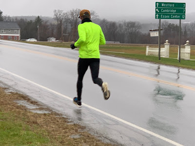
| A runner, possibly trying to counteract a Thanksgiving Day feast, braves a mix of rain and snow for an afternoon jog in Fairfax this afternoon. |
Just as I was getting ready to file this blog update, I noticed rain was rapidly changing to snow in the lowest elevations of Addison and Rutland counties, and in the Champlain Valley.
As temperatures drop this evening, rain should continue changing to snow. I don't imagine we'll see much accumulation the the valley - maybe an inch - but as temperatures fall below freezing, it'll form ice on many untreated surfaces.
Power outages - also as expected - are mounting in Vermont. As of 4:30 p.m. about 4,400 homes and businesses had no electricity. Almost all the outages were over and east of the Gre en Mountains in the southern half of the state.
The snow should slowly end from west to east between 7 and 11 or so tonight. Eastern Vermont remains under a winter storm warning until 7 a.m. Friday because roads will remain treacherous and scary overnight in spots.
The next few days starting tomorrow should be on the cold, bland side, with a little sun mixed with a lot of clouds, with snow showers from time to time. The remnants of some pretty intense lake effect snows will occasionally hit parts of the Green Mountains, dumping snow showers that would accumulate daily on at least some ski slopes from time to time.

No comments:
Post a Comment