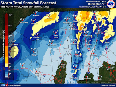
The ingredients are still coming together for an upslope snow event. That's when winds are forced to glide up the western slopes of the Green Mountains, combined with lots of moisture wrapping around a storm to our northeast, will unleash a lot of snow.
The thinking from the National Weather Service in South Burlington is that the spine of the Green Mountains from about the Sugarbush resort in Warren on north through Mount Mansfield and Jay Peak are in for a good 12 to 18 inch dump.
The western slopes - towns like Lincoln, Huntington, Underhill, Jeffersonville, Bakersfield and Montgomery might get a good six to 10 inches of snow.
The Northeast Kingdom and perhaps the northern Champlain Valley away from the immediate shore of Lake Champlain could easily get four or five inches of snow out of this as well.
If you're around the Burlington area, at this point it looks like you're going to see quite a gradient of snow accumulation. At Burlington's Waterfront Park, they'll probably barely manage a dusting to an inch. By the time you get out to Williston, we're talking about a possible four or five inches, if things work out as they now appear.
Note that forecasts can change. This is just an early read on the situation.
Anyone who does get a lot of snow will see it stick around for quite awhile. It will stay too cold for any substantial melting at least through next Wednesday.


No comments:
Post a Comment