Showing posts with label this afternoon. Show all posts

Thursday, June 19, 2025

Early Afternoon Vermont Severe Storms Update: Severe Storm Watch Issued

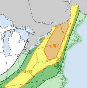
NOAA's Storm Prediction Center around noon
focused on this area, including Vermont that
is likely to have scattered severe thunderstorms
for the rest of this afternoon. 
 A severe thunderstorm watch is now in effect throughout Vermont and eastern New York.

The severe storm watch is effect now until 9 p.m. this evening. 

NOAA's Storm Prediction Center released what is known as a Mesoscale Discussion around noon. These focus on particular areas of interested in which potentially dangerous weather is coming soon.

This one focused on Vermont, eastern New York and part of northeast Pennsylvania. 

According to the statement, storm coverage in the region covered will be pretty scattered and not particularly widespread. But those relatively few places that do get nailed might really get it. 

By far the most likely source of problems from these storms would be damaging straight line winds. We could see a couple places deal with large hail as well.

There's still a very, very low, but not zero chance of a brief spinup tornado.

Even if a particular thunderstorm isn't quite severe when it hits you, watch out for dangerous cloud to ground lighting and torrential downpours. 

Thunderstorms were already firing up in central New York as of 1:30 p.m. They were rapidly heading northeastward toward Vermont. The fact that they were forward speed is so fast means you might not get all that much lead time between the time you might receive a severe thunderstorm warning and the time you actually get the storm. 

It's good that they're moving rapidly, because that won't give them much time to dump enough rain to trigger flash flooding. Still, a couple places could get some flash flooding today if they get "lucky "enough for storms 

After the initial scattered batches of storms that come through Vermont more storms could arrive with additional downpours and lightning. The atmosphere might be somewhat more stable by then, so that might reduce, but not eliminate the chances the evening storms being severe. 

But we're not entirely sure about that, so stay tuned. And keep your eyes to the skies this afternoon. Be ready to move indoors quickly. And have a ready source of receive severe weather warnings, such as wa weather radio or reliable local media. 

Monday, June 21, 2021

UPDATE 1 p.m. Monday: Severe Storm Risk In Vermont, Surrounding Areas Rises

An unusual enhanced risk of severe storms over our
neck of the woods. It's rather rate to have the risk
level that high. Strong, damaging winds are the biggest threat
but still can't rule out a brief twister. 
 A severe thunderstorm watch is in effect for all of Vermont as the risk of severe storms rapidly ramps up over us this afternoon.  

The Storm Prediction Center updated the risk category for us from "Slight," which is second out of five risk categories, to "Enhanced," or level three out of five. It's a bit unusual to have the "Enhanced" category in effect up here in Vermont. 

Strong winds a few thousand feet overhead, with winds changing direction and speed with height, and instability increasing with sun and very humid air.

As forecast this morning, a line of strong storms is expected to form in New York today and sweep eastward. A little ahead of this line, supercells may develop in northern New York, northern Vermont and especially southern Quebec

This ups the ante, with strong straight line winds still the biggest threat from today's storms. The presence of supercells also gives us some risk of hail and even a tornado or two.  NOAA's Storm Prediction Center acknowledges the tornado risk over the North Country. The highest risk is right along the International Border, and even more so up in southern Quebec

That's now to say there will be lots of tornadoes or big ones. But there is still a low, but real risk of a brief twister,especially in northern New York and northern Vermont this afternoon.

The bulk of the storms are forecast to pop up any minute now in northern New York. Actually, as I write this at 1:10 p.m. a couple rapidly developing storms have formed in New York's St. Lawrence Valley. The storms will make it to the Champlain Valley in the 3 to 6 p.m. time range, and further into central and eastern Vermont from 5 to 8 p.m. 

This is by our standards a fairly high end severe weather risk.  Not everyone in Vermont will have a severe storm, of course. But this is more than enough to keep you on your toes.  

Make sure you have access to broadcast severe storm warnings. Power up your devices now in case of electrical failures later. 

If you do get a warning, make sure and get inside a sturdy building and away from windows. These storms are strong enough so that if you're out in your car and you find yourself in a severe thunderstorm or god forbid a tornado warning, it's probably best to find a business in a strong building and wait it out there. 

Once it's safe to do so, report severe storms and/or damage to the National Weather Service in Burlington.  They'll want to know. You can call 'em, but even better, reach out to them on Twitter at @NWSBurlington.