 |
| A little dew on this flower in my St. Albans, Vermont gardens this morning. But a generally dry forecast means I will be watering my gardens more than I have been so far this summer. |
The gradual trend toward less rain in Vermont will really intensity starting, well, on Monday in some places, and by Friday at the latest in others.
It sounds complicated but it's not, really.
The main cold front toward our long talked about cool down is coming through today, but I'm really not impressed by the action we'll see along it.
Let's get into it:
TODAY
It's humid out there, still. And a cold front is at our doorstep. That would seem to be a recipe for a lot of rain and thunderstorms. However, there's dry air aloft, plus the push of cooler air will lag behind the actual cold front.
That leaves with us with only a chance of scattered thunderstorms across the state. At this point, it looks like less than half of us in the northern half of the state will see those showers and storms. In southern Vermont, there will just be isolated storms.
Some of those few storms this afternoon and evening could still be pretty strong. The dry air aloft can get entrained in some of the storms. When that happens, you can get strong bursts of winds from these storms.
So, NOAA's Storm Prediction Center gives the southeastern two thirds of Vermont a marginal risk of severe storms. That's the lowest of five risk levels. That means maybe one or two places might have wind strong enough to damage trees or power lines,
I would say maybe only 30 percent of us will get a nice downpour out of these storms. The rest will of us will see anything from nothing to perhaps a mere tenth of an inch of rain. So no biggie.
Since the cooler air will be lagging, today will end up being one more very warm day. Highs in the 80s north, with some low 90s in warmer southern valleys.
THURSDAY
Boy, you'll notice the change in the air tomorrow.
The cold front will have gone through Vermont, meaning all of us will face cool weather for a big change. Most of us will see highs only in the 70 to 75 degree range. A few places will stay in the 60s, especially since clouds will help keep temperatures down.
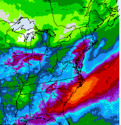
That cold front still looks like it will stall temporarily in southern New England, A wet little storm will ride along the front, but there remains debate as to how far north the rain with it will come.
Southern New England looks like it's in for a good drenching with one to as much as three inches of rain anticipated.
The rain will probably work north into Vermont, but how far and how much is still anybody's guess.
Meteorologists are anticipating a sharp south to north boundary between heavy rain and practically nothing.
If I have to take a shot at it, I'd say Bennington and Windham counties in the far south could see a good half inch of rain out of this. There could be over an inch - maybe - near the Massachusetts border if things turn out just right.
Light rain could make it as far north as central Vermont, but it will be battling dry air (and a little wildfire smoke) blowing in from the north. We'll let you know if the forecast changes
In any event, this sets us up for a real dry period, especially in central Vermont.
DRY ERA
Central Vermont has missed out on the rain lately more than the far north and far south has or will. It also looks like we'll have little or no rain anywhere in Vermont starting Friday.
Sunny skies and low humidity are in the cards Friday through Monday at least.
The relatively cool temperatures of Friday and Saturday will recover to slightly above normal temperatures again Sunday and continue all of next week. (Highs in the 80s)
All that dry weather means many of us will be watering our gardens in some cases for the first time since last summer, considering how wet our spring and early summer was.
The humidity will start to creep up later next week, which opens the door for spot showers and storms starting maybe the middle of next week.
But at this point, I don't see any widespread drenchers for quite a long time.
This isn't necessarily the start of a drought, but we will have to start being careful with outdoor fires starting this weekend. The forest fire danger will start to go up.


No comments:
Post a Comment