
 |
| Not what you see too often in Vermont. This time/ temperature sign in downtown St. Albans, Vermont showed 97 degrees Monday. The city ultimately reached 99 degrees as record high temperatures were shattered across Vermont. |
This is one remarkable heat wave. Easily one of the most extreme on record, especially for so early in the season.
The only hot spell I can remember that had anything close to this extreme combination of heat and humidity was in July, 2018.
The only thing keeping this week's heat from being one of the biggest hot spells on record will be its short duration. The extreme heat will have only lasted two days. Mercifully.
INCREDIBLE RECORD HIGHS
The heat over-performed in some places around here Monday, exceeding some of the wildest forecasts.
The big winner was Plattsburgh, New York, which ultimately reached 101 degrees. That ties the city's all time record high, set on August 1 and 2, 1975 and August 5, 1955.
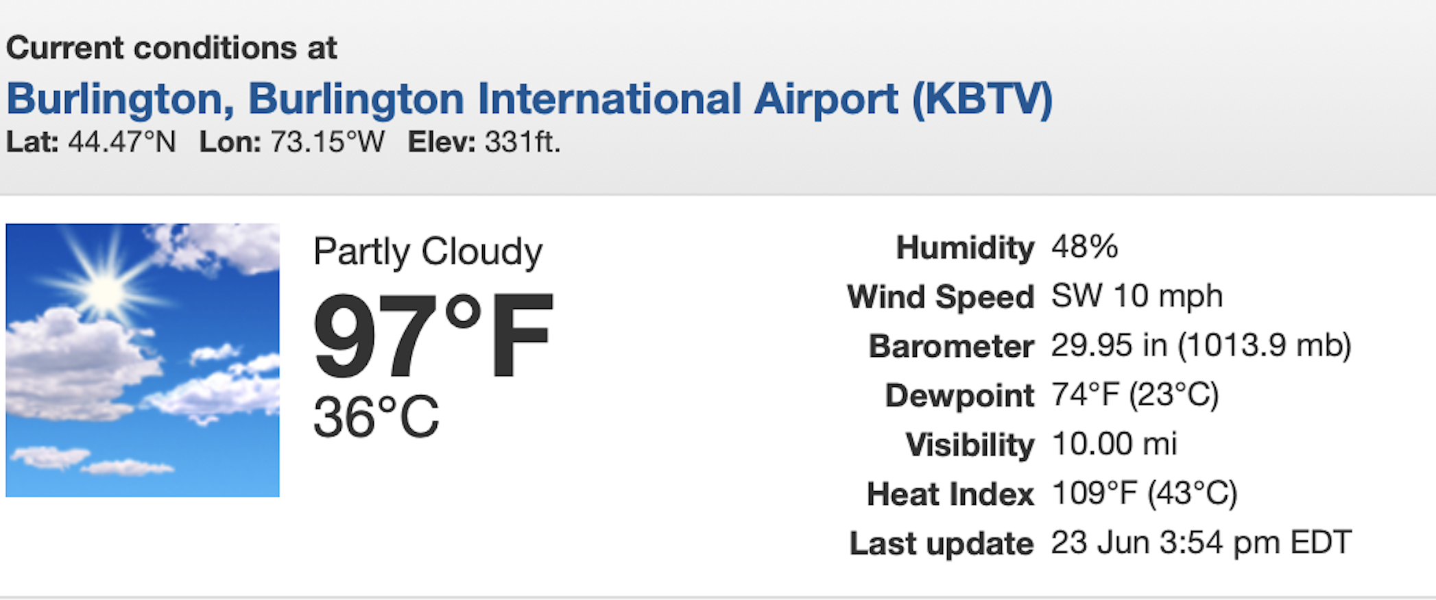
Burlington's Monday record high of 99 degrees was almost as impressive as Plattsburgh's. It's the second hottest day on record for the month of June. It's a tie for the third hottest day on record in Burlington. Monday was only the ninth time on record that it has been 99 degrees or hotter in Burlington. Those records go back to the 1880s.
Back in the day, June was usually not a particularly hot month. The real heat of summer usually hits in July and August.
I suspect the effects of climate change first began to noticeably hit in the late 1980s. In the 87 years that passed between 1900 and 1987, only five Junes in Burlington had temperatures of 95 degrees or more. In the mere 37 years since 1988, it's now gotten to 95 degrees or hotter 14 times in Burlington's Junes.
I guess we need to expect more of this in our increasingly climate-change driven world.
Elsewhere in Vermont and New York, record highs fell like dominoes. St. Johnsbury reached 97 degrees on Monday, breaking the old record of 93 set in 1989. Montpelier got up to 93 degrees, breaking the old record of 90 degrees.
Other high temperatures in and near Vermont include 99 degrees in St. Albans, Vermont and Lebanon, New Hampshire; and 97 in Springfield, Vermont. A full list of Monday high temperatures provided by the National Weather Service in South Burlington shows there was no escape from the heat in Vermont. Everybody was in the 90s.
HUMIDITY/HEAT INDEX
 |
| The 4 p.m. report from Burlington Monday showed a heat index of 109. Several Vermont towns had incredible heat index readings of 115 degrees or more, |
Nobody really keeps track of record dew points, but NVU-Lyndon Atmospheric Sciences says the highest dew point seen in Burlington was 77.8 degrees at 4:10 p.m. on July 2, 2018.
During the height of Monday's heat, the dew point in Burlington was 75 degrees. There were some reports in Vermont of a dew point at or above 80 degrees, which to me had been previously unheard of this far north in New England. '
The resulting heat indexes were brutal, especially where the humidity was especially high. Those indexes peaked at incredible - and very dangerous levels - 119 degrees at Highgate Falls, right up there near the Canadian border; 118 degrees in Colchester and Cambridge, and at or above 115 in several other Vermont communities.
The result was a hunkered down Vermont.
I went out and did some errands Monday. (The air conditioner in my truck was fixed just last week, phew!). Out on the streets, it sort of looked like it does during a snowstorm. Minus the snow, of course.
Traffic was lighter than usual. I saw very few people walking on sidewalks. Downtown St. Albans was practically a ghost town as the heat peaked in the mid and late afternoon. Outdoor construction sites were shut down and abandoned in the heat of the afternoon. Some of the beaches were less crowded than you'd expect. It was simply too hot for the beach.
I know this kind of weather is pretty routine in places like Houston, New Orleans and Miami. Though Miami was actually cooler and less humid than Vermont was on Monday.
It's disconcerting to have their kind of weather here. Just as it had to be a little scary when the first-ever major snowstorm and near 0 degree cold snap that swept the Gulf Coast last January.
TODAY
After a terribly stuffy night, today should be almost as bad as Monday. When I went out to water the gardens at 7 a.m. today, it was already sweltering.
Some Vermont towns, especially north and central, might not be quite as hot as Monday because a cold front will be approaching from the north. That might throw some clouds and even a few thunderstorms into the picture this afternoon, tempering the heat just a bit.
(I'll get into those thunderstorms in just a bit)
Burlington's expected high temperature is now forecast to be 95 degrees. The record high for today is 96 set in 2003. So we might avoid a record high there today, we'll see.
One wild card is the humidity is just a slight hint lower than yesterday. Actual temperatures under sunshine can more easily get hotter when there's less humidity. If the clouds hold off in the north, we could shatter more record highs.
Southern Vermont should avoid the clouds through the day, so they might actually be a little hotter than Monday. Or at least just as hot. We'll be looking to see if anybody in Vermont's lower Connecticut Valley makes it to 100 degrees today. I wouldn't be surprised if that happens.
THUNDERSTORMS
Usually when it's this extremely hot, the atmosphere is a powder keg, ready to explode with violent thunderstorms. It just needs a spark.
That spark is usually a cold front. And, as mentioned, here comes a cold front. So yes, a few thunderstorms might fire up today and this evening, especially north and central, and there's a chance a couple of them could have damaging wind gusts.
But the thunderstorms probably won't be as widespread as you'd expect. There's a layer of dry air very high up in the atmosphere, which would limit how many thunderstorms can form.
Also, when a cold from is approaching, the air in the upper atmosphere usually cool first, before the less hot air arrives at the surface. That contrast between the hot surface and the colder upper atmosphere tends to fire up thunderstorms. This time, the upper atmosphere won't really be cooling much like it usually does ahead of the cold front this afternoon. This will also limit the number of storms.
BLESSED COOLNESS
You'll notice the change in the air and the temperature on Wednesday. It'll still be warm - in the low 80s north to upper 80s south. The humidity will be declining, especially north. The result will be a delightfully warm and dry and pleasant northern Vermont. Southern Vermont might remain a little uncomfortable, but will improve through the day.
Daytime temperatures might actually be near or slightly cooler than normal Thursday through Saturday, with highs only in the 70s.
Tonight's cold front will stall only a little to our south, so it will try to start coming back as a warm front late in the week. We'll still be on the cool side of it, but it looks like it will touch off some showers and maybe storms Friday and Saturday.
It's beginning to looking kind of warm and somewhat humid this coming Sunday and Monday, but it shouldn't get nearly as torrid as it did yesterday and today.
No comments:
Post a Comment