 |
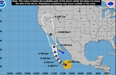
| One forecast for the path of Hurricane Hilary. If it arrives as an intact tropical storm by the time it reaches California, it'll be the first time since 1939 that's happened. |
The song is actually partly true. It almost never rains in southern California, at least in the summer. If it does rain during the summer, it's scattered and brief and doesn't amount to anything.
Or not.
The coming days could well be an exception to that no rain rule. A tropical storm, or at the very least its remnants, appear poised to blast much of California, including, or even especially southern California in the coming days.
The culprit is Hurricane Hilary, which was rapidly gaining steam today well off the central Mexican west coast. It has top winds of 105 mph and is expected to strengthen rapidly.
Most hurricanes that form near the west coast of Mexico or Central America usually either hit the southern or central west coast of that nation and quickly die, or the bash into Baja California and wind down quickly there. Or even more often, they head northwest and fall apart in the chilly Pacific Ocean waters southwest of California.
A few of these Central American or Mexican-born storms launch long journeys westward into the central Pacific Ocean roughly toward Hawaii, as the recent "Dora the Explorer" hurricane did this month.
This isn't the case with Hilary. Steering currents are bringing it northward toward the long Baja California peninsula. If Hurricane Hilary makes landfall into Baja California, it'll fall apart, but still give the southwestern United States heavy rain and flooding over the weekend or early next week.
If Hilary stays just off the west coast of Baja, that's a different story. The water is cold off of Baja and southern California. Hurricanes hate cold water, so they weaken when they encounter such conditions.
However, Hilary will be a strong hurricane on approach. So it'll take awhile for it to weaken as it comes toward California. Plus the cold water off the coast isn't nearly as chilly as it usually is. That's thanks in large part to the current El Nino, with an assist from climate change. So that would slow the weakening process too.
If Hilary is still an intact tropical storm by the time it lands in California - an iffy but still real possibility, it'll be the first time since 1939 that a tropical storm has hit California. (There have been other instances in which former hurricanes and tropical storms have unleashed flooding and locally damaging winds hit California, but this is after they transitioned to non-tropical storms).
The September, 1939 tropical storm dumped 5.62 inches of rain on Los Angeles and more than 11 inches on Mount Wilson, California. Winds gusted to 65 mph in parts of southern California.
Storm surges devastated Long Beach and other coastal communities. A total of 45 people died in that storm.
A hurricane or strong tropical storm is also believed to have struck southern California in 1858.
The 1939 hurricane hit under similar conditions to today. A strong El Nino was in progress. An intense heat wave scorched southern California in the days leading up to that storm. A strong heat wave is now hitting parts of that region.
Whether or not Hilary maintains itself as a tropical storm by the time it reaches California, heavy rain and flash flooding now seem almost inevitable. At least scattered areas of flash flooding, but probably more, are in the forecast for much of California starting Saturday and continuing through Sunday and into early next week.
Remember that song I mentioned at the top, how it never rains in Southern California? I think a lyric from that song is about to come true: "But girl, don't they warn ya: It pours, man it pours."

No comments:
Post a Comment