 |
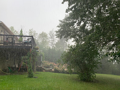
| Thunderstorm dumping a small footprint of heavy rain on part of St. Albans, Vermont Tuesday. |
As expected, scattered showers and thunderstorms developed, and oddly moved east to west over the state.
While many places, especially south of Route 4 saw little or no rain, a few spots got some surprisingly strong thunderstorms
The strongest storm in the state bullseyed my area in St. Albans, Vermont , and especially up in nearbyHighgate Springs.
Before the main storm arrived, a small but beautiful storm erupted right over the northern part of St. Albans and drifted southwestward on a path toward Plattsburgh. It cracked with lightning and had a narrow but intense rain shaft, as you can see in the photo in this post. The storm dissipated over Lake Champlain before reaching the Plattsburgh area.
This was followed by a larger and more intense storm. There was continuous thunder for nearly an hour at my place from the slow moving storm. When it hit, I got 35 mph wind gusts, hail a half inch in diameter and a half inch of rain in less than 25 minutes.
 |
| Thunderstorm developing east of Fairfield, Vermont Tuesday afternoon. The storm became quite strong as it moved the "wrong way", westward toward St. Albans. |
Today, the backwards weather will continue in Vermont. But instead of Tuesday's picturesque showers and thunderstorms, we'll just increasing clouds with a rising threat of relatively light rain. Again, the rain will be moving the wrong way, east to west instead of the normal west to east thing. It's that pesky odd nor'easter off the coast still up to its tricks.
The storm was well east of the southern New England coast early this morning. Some rain was working its way into that area, which is suffering a nasty drought, but it won't be nearly enough to solve the problem.
The whole storm is actually about to head the "wrong way." They usually continue on toward the northeast, but this one is forecast to make a left hook and actually come ashore in Downeast Maine.
This will be close enough to produce at least a little beneficial rain to Vermont. And it won't be hit and miss, either. It's not a huge rain storm. The National Weather Service in South Burlington is forecasting generally a quarter to a half inch of rain west of the Green Mountains and a half to three quarters of an inch along and east of those mountains.
 |
| A mix of very heavy rain and small hail during a thunderstorm Tuesday in St. Albans, Vermont |
The bulk of the rain will come from early this evening to Thursday morning, with lingering showers tapering off during the day Thursday.
All in all, the rain, though not impressive, is turning out to be a nice surprise, if we actually receive it.
It's still looking like we're back to normal weather starting Friday and going into early next week at least. We'll resume the normal west to east path of weather systems, and it will warm up to feel like summer again.
The next chance of any rain after tomorrow looks to be early next week. So far, I'm not feeling bullish on a lot of precipitation Monday or Tuesday, but at least the chance is there.

No comments:
Post a Comment