
 |
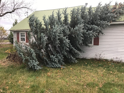
| Shallow-rooted trees, like this spruce that was the victim of a wind storm in Milton, Vermont back in 2017, are at risk today. Wet, squishy ground combined with today's high winds make this type of tree a little more likely to fall over in gusts at or over 50 mph |
As I began to write this before dawn this Monday morning, it wasn't really that windy yet. It was gusting to only roughly 20 mph here in St. Albans, and I hadn't seen anything much above 35 mph in Vermont yet.
An area of rain associated with the storm's warm front was temporarily stabilizing the air, and preventing strong winds aloft from mixing down to the surface.
It will still get quite windy today, and perhaps by the time you're reading this, the wind will be howling where you are.
It was already starting by the time I was finishing up this report. Winds were starting to pick up outside my window, and the first few power outages of the day in Vermont were starting to pop up in Franklin County, which is in the northwestern part of the state where I live.
The National Weather Service offices in South Burlington and Albany, New York have expanded today's wind advisory to cover all of Vermont, except perhaps a tiny sliver in the far southeast corner. That wind advisory had only covered far northern Vermont and the northern Champlain Valley earlier.
The wind could gust to 50 mph or perhaps even more state wide. The expected low level jet, a ribbon of fast moving air a few thousand feet overhead has developed, and it looks like it might be a little stronger than in earlier forecasts.
The National Weather Service in South Burlington was measuring winds of 90 mph about 5,000 feet overhead. Winds early this morning gusted to 95 mph atop Mount Mansfield.
Bits and pieces of this wind aloft can mix down toward the surface, causing today's nasty gusts. We won't see 90 mph winds, but winds could still easily exceed 50 mph in some spots in Vermont today.
The National Weather Service in South Burlington notes that the most troublesome time with this wind will come mid to late afternoon, when the storm's strong cold front comes through. It'll probably have a line of pretty decent showers with it, possibly even some out-of-season thunderstorms.
These showers might well end up being really good at grabbing that high velocity air above us and taking some of it down to the ground where we live. That cold front will probably be the peak of today's wind. It will likely be when most power outages blossom across the state. There might be reports of winds of up to 60 mph with this front. We'll see!
It'll stay quite windy behind the cold front as temperatures crash tonight. Winds could still gust over 50 mph in spots, especially on the eastern slopes of the Green Mountains. That's because after the cold front passes, the wind will have shifted from the south to the northwest.
The winds coming up and over the mountains will gain some downward momentum as the gusts sweep down the eastern slopes.
Winds will finally gradually diminish Tuesday.
The ground hasn't really frozen yet. Snowmelt and the bit of rain we're getting today is making the squishy ground underfoot even squishier. That means shallow-rooted trees will have a better shot at blowing over than if the ground were more firm.
Rainfall with today's windy storm won't be tremendous, so I'm not seeing a flood threat, other than perhaps a wee bit of urban flooding in poor drainage areas if the showers and storms with the cold front are heavy enough.
Following this storm, the model trends have continued with the idea of canceling any real snowstorm on Wednesday. There could be a little light snow then, but no biggie.
More snow, or more likely rain, seems possible this weekend. Stay tuned.
No comments:
Post a Comment