
The snow totals coming in are stunning late this afternoon.
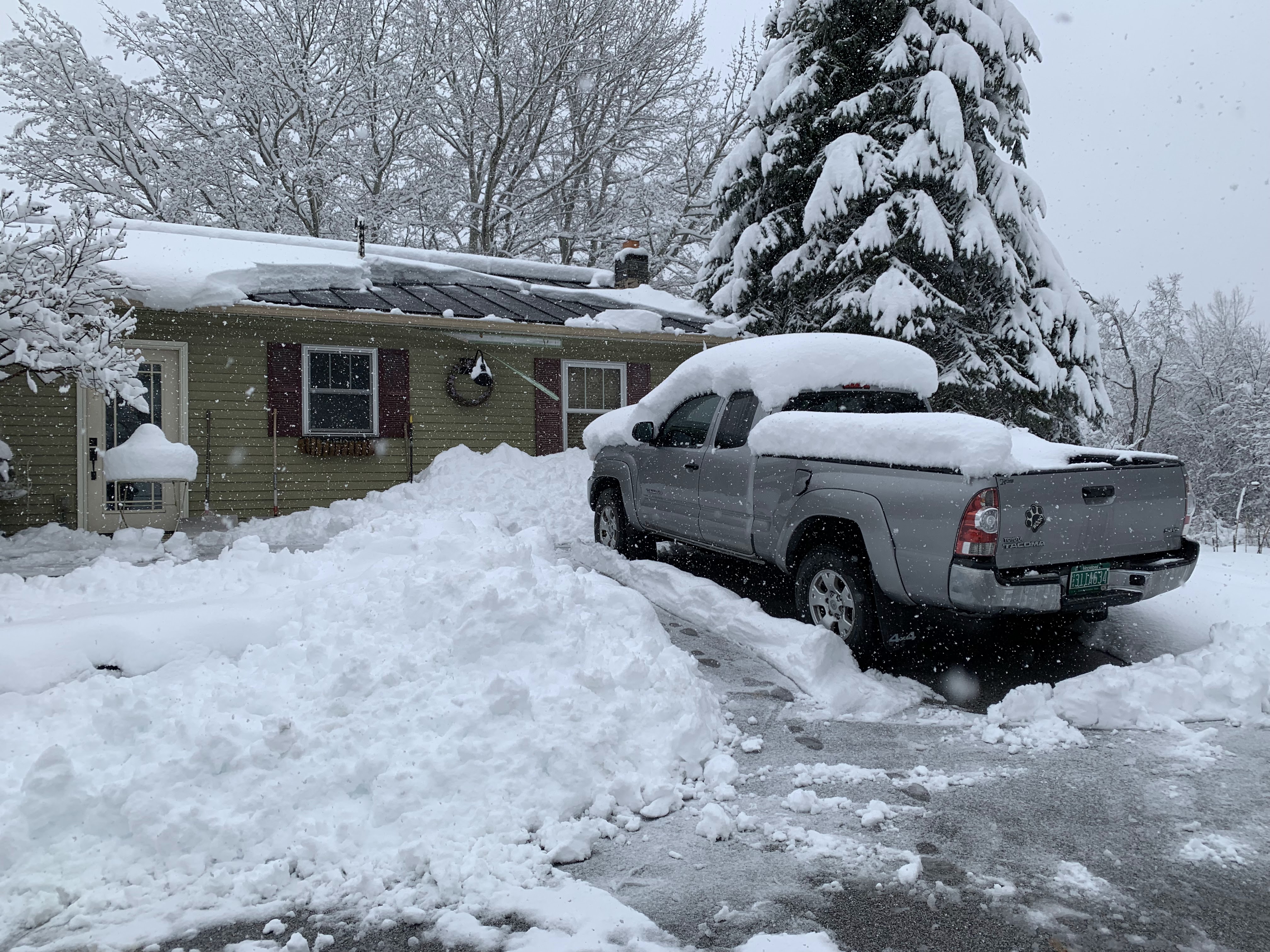 |
| Cleanup sort of began on my property in St. Albans, Vermont late this afternoon as the flakes continued to fly. Thirteen inches so far at my house. |
I saw numerous reports of snow totals so far in the 12 to 16 inch range.
Looking through record books, I'm hard pressed to find a bigger April snowstorm in Vermont.
Perhaps the one in April, 1975 was bigger, with a maximum amount of 30 inches in Peru, Vermont. But I'm not 100 percent sure the 1975 event had deep snow quite as widespread as we saw today.
There was a large snowstorm in April, 1974 that might have rivaled this one, too. You have to go all the way back to 1807 to find a Vermont April snowstorm decisively larger than the one we got today.
Officially, Burlington received 8.8 inches of snow as of late afternoon.. That would make it the third snowiest April day on record there. Top honors for biggest Burlington April snowstorm goes to the 15.6 inches on April 16-17, 1983. That particular snowstorm is also in the running, - along with today's - as the biggest April snow blitz for Vermont.
I would hazard a guess and say at least 90 percent of Vermont at minimum six inches of snow. Many towns are already over a foot.
Some communities that usually miss out on the heaviest snow from powerful nor'easters got nailed. So far, I've tallied 13 inches in my northwestern Vermont town of St. Albans
And it's not over. More snow reports are coming in, and most of us will see snow falling all night tonight and maybe into Friday. It won't snow as hard as it did today, but it will snow. A number of locations will snow all night and into Friday.
This is a pretty long post since so much is going on, so let's get to it.
The Roads
It's very unusual for it to snow hard enough to keep roads slick during the day in April. The high sun angle cuts through the clouds to melt snow on dark pavement. But one to two inch snowfall rates today kept roads slick.
Sometimes, it would just be wet pavement during a relative lull, and then the snow would pick up and it would be slushy and icy and snowy again.
 |
| Traffic camera picked up this slide-off along Interstate 89 in Middlesex earlier today. Vermont State Police reported that they've responded to more than 100 crashes since last evening. |
The result was havoc on the roads.
Vermont State Police said they responded to 111 crashes between 6 p.m. Wednesday and 3 p.m. today. Most of them were in the northern half of the state. I anticipate more tonight.
Especially once the sun goes down, roads will ice up again and become snow covered. Especially near the Green Mountains where snow should be steadiest overnight,.
Many roads or sections of roads closed through the day as crashes, fallen trees and wires caused a lot of issues. I wouldn't be surprised if more road closures hit overnight, as more trees will probably collapse. They pace at which they'll fall will probably be slower, because snowfall won't be as heavy and the snow that does fall won't be as wet as it was today.
Power Outages
Power outages persisted all day as the snow continued to fall. It was pretty wet and heavy, especially in lower elevations, so trees and branches kept collapsing all day.
The number of outages stayed near or above 30,000 all afternoon. That's more than twice the amount of outages we saw in each of those twin giant wind storms back in January. The number of outages began to tick down late this afternoon as snowfall rates became lighter and repair crews could start to play catch up.
That 30,000+ figure wasn't the total number of outages either. It was just the number of homes and businesses without electricity at any one time today. Some areas lost power last night, or during the morning or midday and it had it restored during this afternoon.
I'm sure the number of outages will fall more dramatically overnight and especially on Friday. But I have to wonder if some people will be out all weekend. It's that bad.
This nor'easter caused all sorts of problems throughout New England today. We had coastal flooding and wind damage in southern New England. It wasn't just Vermont that had the deep, wet snow and power outages. New Hampshire, Maine and southern Quebec were all hit hard.
At least 600,000 homes and businesses lost power in Quebec, and many of those won't be restored for a few days.
What's Next?
It was still snowing in much of Vermont late this afternoon. The intense nor'easter was still sending a fetch of very wet air west and northwestward through New Hampshire into Vermont, northeastern New York and southern Quebec. The batches of snow in this air flow have gotten lighter and a bit more scattered, which is why the accumulation rate is slowing.
As the nor'easter heads into the Gulf of Maine overnight, those wet east winds will end. Instead, a moist northwesterly win will take over. That will favor the most snow in the western slopes of the Greens and the summits. Especially from about Killington north.
From now until Friday morning, valleys - including the Champlain Valley - should see another one to four inches of new snow by dawn Friday. The Green Mountains and some of the northern Vermont western slopes will probably be closer to four to eight inches additional. Low elevations of southeastern Vermont will probably get less than an inch.
The snow showers will continue all day Friday, but mix with or change to rain in the valleys as temperatures manage to get into the 35-40 degree range. The valley rain or possible snow showers will be light and won't amount to much. Elevations over 2,000 feet could get another couple inches.
More snow showers Friday night into Saturday will bring a little more snow to the mountains.
In the valleys, the weather will grudgingly continue to improve. Saturday will bring highs to the low 40s in the low elevations. That's still chilly for this time of year, but it's an improvement and will start the thaw.
Sunday could bring some sunshine, especially in the afternoon and evening. The snow will help refrigerate the ground, holding temperatures in the 40s.
That refrigeration will continue on Monday, eclipse day, but we'll still manage highs in the 46-52 degree range, which isn't bad. Had there been no snowstorm, I imagine highs Monday would have been in the 50s to around 60. Oh well, no biggie.
Meteorologists are still clinging to the idea of at least partly clear if not mostly clear skies at the time of the eclipse. Some high clouds might be moving in from the west, and/or some scattered lower clouds might sneak in from the north.
But the forecast I made years ago when I first heard of the eclipse looks like it will not come to pass I'd long predicted dense fog and freezing drizzle for eclipse day. I'm a glass half empty kinda guy I guess.
I'll have more on this storm tomorrow and beyond,, including updated totals, updated forecasts, how the snow might affect eclipse day, and thoughts on whether all this snow will cause flooding in the weeks ahead.
No comments:
Post a Comment