That's the opening salvo in our long awaited storm.
The Wind
The first high impact phase of the storm was just beginning as of 5 p.m. Behind that band of precipitation that passed through, a slot of dry air is moving in. Within that patch of dry air is the strongest winds. Especially west of the Green Mountains,
So far today, I've seen gusts as high as 43 mph in Burlington, and I'm sure there's already been a few reports of wind a little stronger than that. I did see a report of a 49 mph gust in Janesville.
As of 4:30 p.m., you could tell from VTOutages.org the strong winds had started in southwestern Vermont and were moving north.
At 4:30 p.m., about 1,800 homes and businesses were without power, mostly in Bennington and Rutland counties. That number of outages was increasing pretty fast.
The Precipitation
The National Weather Service in South Burlington seemed like it was hedging its bets late Wednesday afternoon.
The computer models still suggest Vermont will see a lot of snow, at least in elevations above 1,000 feet. But reading between the lines, experienced meteorologists have some skepticism.
This sprawling system seems to be ingesting bits and pieces and areas of dry air, which could occasionally cut down on the rate at which snow, sleet and rain will fall tonight.
It also seems like a layer of warmish air aloft will be a little more widespread and persistent overnight, especially in central and southern Vermont. That would create a better chance of more sleet, along with a bit of freezing rain and rain, and less snow.
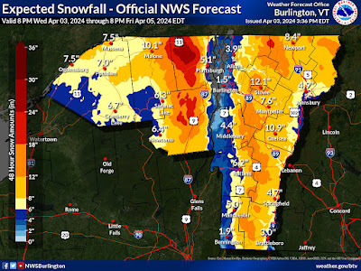
Still, the official forecast has six to 12 inches of snow piling up away from warmer valleys and mostly at elevations of 1,000 feet or more. Most places in the Champlain Valley, lower Connecticut Valley and lowlands around Route 7 between Brandon and Bennington should stay under six inches. A few mountain summits could make it to two feet of new snow.
Plan on crappy road conditions statewide for the Thursday morning commute, but results will vary. Some places might be just slushy, others could be very snowy, with very low visibility in snow and possible blowing snow. Especially at higher elevations.
 |
| High elevation Route 9 in Marlboro was already starting to get slushy as of 4:30 this afternoon as the initial patches of snow and mixed precipitation began making their way through Vermont. |
Precipitation rates will lessen during the day Thursday. But depending on where you are, it will still be either a solidly snowy or slushy day. Warm spots go above freezing during the day, but not by much.
That will make any measurements of snow tricky. Elevated and grassy surfaces might continue to collect snow, but pavement and plain dirt might see more melting. We'll see. Higher elevations should see a continued, gradual accumulation of fresh snow all day.
A wild card is whether wet snow will accumulate fast enough on trees and power lines to trigger additional power outages. The winds will be much lighter during the day Thursday than they will be overnight, but snow might interfere with crews trying to restore power.
The Wind Down.
It still looks like this whole thing will ever is slowly diminish with time from Thursday night through Saturday. Snow and valley rain showers during the days will become lighter and lighter and more and more scattered.
There might even be a hint or two of sun on Saturday, and if we're lucky a fair amount of sun Sunday.
Temperatures will slowly climb out of the rut we'll be in tomorrow. Valley highs on Thursday will be between 30 and 38; then 34 to 42 or so Friday, perhaps 38 to 46 Saturday and in the upper 40s Sunday.
I'm waiting for the other shoe to drop and ruin it, but forecasters are still calling for partly to mostly sunny skies when the eclipse hits Monday afternoon.


No comments:
Post a Comment