Showing posts with label San Francisco. Show all posts

Saturday, December 14, 2024

San Francisco A New Tornado Alley. At Least On Saturday

Storm damage in San Francisco Saturday, after
the city had its first-ever tornado warning.
Meteorologists are now investigating whether
a tornado actually touched down. Photo by
Richard Pena via Mission Local 
UPDATE, NOON SUNDAY

Judging from news from the National Weather Service office in the Bay Area, a tornado did not touch down in San Francisco. It looks like the damage was also caused by intense straight-line winds.

However, they did confirm that tornado in Scotts Valley, just north of Santa Cruz

It was an EF-1 with 90 mph winds. The tornado had a short path length, about a third of a mile. Local media reported six injuries, three of whom were hospitalized and one of those people was critically injured. 

Most of the injuries appear to be occupants of vehicles that were flipped over by the tornado or caught outdoors as pedestrians. 

PREVIOUS DISCUSSION

Even in December, I would never be all that surprised if a tornado hit somewhere in Oklahoma, or Alabama or Florida.  

But San Francisco?

The first-ever tornado warning that anyone's aware of was issued for San Francisco early this morning. 

As of early this evening, it's still not confirmed whether a tornado actually touched down in the city, but there is wind damage, and radar showed a classic tornado signature. 

The tornado warning was issued at 5:51 a.m. local time and expired about 25 minutes later. 

There's quite a bit of tree damage in Golden Gate Park, where some of the strongest rotation was detected on radar.

Meteorologists with the National Weather Service office in Monterey, which covers San Francisco, plan to investigate the park and perhaps other sections of the city to determine whether it was a tornado or straight line winds that caused the damage. 

Winds reportedly gusted to 83 mph during the storm at San Francisco Airport.

Radar images Saturday morning  also indicated debris being lifted into the air and strong rotation in Davenport, California.  Davenport is along the California coast about 60 miles south of San Francisco.

Video showed either the same apparent tornado or a different one in Scotts Valley, California, about a dozen miles east of Davenport and just north of Santa Cruz, California. 

Although tornadoes have occurred near San Francisco in the past, none are known to have actually passed through the city. 

The possible tornadoes were part of a strong storm that slammed into northern California last night and today. A constellation of flood and coastal flood alerts, wind advisories and winter storm warnings were up for various parts of northern California.

A good two feet of snow was expected in parts of the Sierra Nevada range, and avalanches are likely in the back country.  Traffic was snarled Saturday in highways through the mountains.  

At this point, the storm that hit California today is not expected to become a major system as it crosses the United States 


Monday, September 20, 2021

Fog Season In Vermont; Fog Attacks Power Grid On West Coast

In this morning visible satellite photo, you can see
fog hugging the Connecticut River Valley, and parts 
of the Winooski and White River Valleys. You can 
also see fog running up the valleys that go along
the tributaries of these rivers.
 I'll get to the first part of the above headline first, because - huh???   

Usually, when electricity goes out for weather related reasons, it's because of high winds or lightning.

But in the San Francisco Bay Area on Sunday, 29,000 lost power because of a decidedly non-violent weather event: Fog and drizzle.

In the Bay Area, it generally doesn't rain in the summer.  According to television station KPIX, dust and debris settles on power lines and power equipment over the dry summer months.

  When dense fog and drizzle finally arrives with the first autumn storm, as it did Sunday, the moisture interacts with the debris and dirt to cause flashovers. And Voila! power failures.

I mention that weird Bay Area weather story in part because here in Vermont, we're in peak morning fog season. We don't have to worry about fog-related power failures, because it rains so frequently here in the summer that dust and debris don't accumulate on power equipment.  

Here's why we get so much morning fog this time of year:  The ground and the water are still warm from the summer. Nights are getting cooler, especially the nights with clear skies and light winds, like we had last night. 

Warmth and moisture rising from the ground and water hits the cold air and condenses into fog.  Often thick fog.  You really have to be careful driving early in the morning on days like this because of the patchy nature of the fog.

You're cruising along and you can see for miles and suddenly you're in a fog bank and you can't see a thing. If you're not paying attention and you're unlucky, you then crash into the invisible car in front of you in this pea soup. 

On the literally bright side, the sight of morning sun piercing the fog is gorgeous, and makes for some absolutely stunning photography.  So it's probably a good idea to have your camera with you on foggy mornings.

This morning was a classic Vermont fog morning. Last night, as noted, was clear and a bit chilly. Dense fog filled many of Vermont's river valleys. I noticed towns like Montpelier, Morrisville, Lyndonville and Springfield all reported dense fog this morning. 

Meanwhile, my place is perched on a hill in St. Albans. Nothing but blue sky out there for me. 

You can see the fog outlining river valleys in the satellite photo in this post. 

The next few nights will probably have less fog than this morning, because breezes will be picking up.  Overnight winds tend to disperse fog before it can get too dense.  The fog for the next few mornings will probably limited to the deepest valleys most protected from the wind.

However, we're likely to have more foggy mornings, at least until most of the leaves are off the trees.  Leaves emit moisture, and losing those means a source of water for the fog goes. Also, once we get into late autumn, it's more often than not too windy to sustain morning fog. 


Tuesday, August 18, 2020

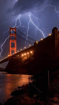
California Lightning Barrage Sets New Fires. Also, Tropical Trouble

 Two days of rare northern and coastal California lightning have sparked a bunch of new wildfires as a record heat wave rolls on. 

It's certainly rough going out there this week. 

The thunderstorms only produced a little rain, but created lots of lightning strikes. The vegetation is bone dry, so even the bits of rain that came with the storms failed to prevent fires.

Summer lightning storms like this are extremely rare in the San Francisco Bay area and Napa Valley, so this is another example of weather off the rails.

As the Los Angeles Times reported: "'Wild night in the San Francisco Bay Area. This is probably the most widespread and violent summer thunderstorm event in memory for the Bay Area, & it's also one of the hottest nights in years,' tweeted Daniel Swain, climate scientist with UCLA and the National Center for Atmospheric Research."

These types of thunderstorms are rare in California because the air is dry over land. The nearby ocean water is cool, which stabilizes the atmosphere. But moisture from a dying tropical storm made it northward all the way to the Bay Area.  The heat wave added to the unstable air mass, and thunderstorms blossomed.

Water temperatures along the coast of California are still cool, but warmer than normal, so that might have contributed as well.

By 4:30 a.m,  Sunday, firefighters were at seven brush fires in the Bay Area caused by lightning, the L.A. Times reported.  More storms and dry lightning hit on Monday. A video compilation of the lightning is at the bottom of this post. It's pretty cool.

This comes in the middle of a strong, long heat wave. Records highs have been set all up and down the West Coast in recent days.  After what might be a world heat record of 130 degrees Sunday in Furnace Creek, California, the town had a chillier day Monday as the high only reached 127 degrees.

Today, heat warnings and advisories are up for a huge area of the West from central and southern California, Arizona all the way up to Idaho and Montana.

Red flag warnings for high wildfire risks cover most of these same areas.

TROPICS HEATING UP

Right on cue, the Atlantic tropical storm machine is cranking up right about now, as forecasters have been telling us they would at this time.

Last week we had tropical storms Josephine and Kirk, both of which were really nothing burgers that didn't affect anybody on land to any extent. 

Right now, though, there are two storms brewing that seem to to warrant being put on the watch list. 

The first is a disturbance just about to head westward into the Caribbean Sea.  Its forward motion is so quick that the disturbance can't get its act together, so it's unimpressive now. The National Hurricane Center thinks this batch of showers will slow down and encounter better conditions to develop into something more serious in the western Caribbean in a few days. 

Further to the east out in the open Atlantic, an impressive cluster of storms moved off the coast of Africa a few days ago. This patch of storms is getting more organized, and a tropical storm should form out of this within a few days. 

It's way to early to know how, or even if, either of these wannabe storms will affect the United States or other populated areas.  However, both do show signs that they could hit land eventually.  The National Hurricane Center is certainly monitoring all this. The two wannabe storms will probably be featured in future posts of this here blog thingy.  

Video:

Different views of the California lightning: