Thursday, March 31, 2022

Is Severe Weather Heading North, And Doing So Out Of Season?

A rotating supercell thunderstorm over the northwestern 
corner of Vermont on May 4, 2018. This storm did not
produce a tornado, but might have been one example of 
how severe weather has been shifting north and east
in the United States, and this has been doing so
earlier and earlier in the season. 
Severe thunderstorms were rumbling in the Mid-Atlantic states this afternoon, as far north as southern New York. 

It's one possible example of a trend that has severe weather and tornado outbreaks become more likely over the years in the Northeast.  

The trend also seems to include more early season severe weather in the northern tier of the United States.  

Big tornadoes have long been seen  as being creatures of Oklahoma, Texas and Kansas. Think Dorothy in the Wizard of Oz.

As I noted Tuesday, so called "tornado alley" has generally shifted eastward into the Gulf Coast States and Mid-Mississippi Valley.   

The tornado targets are also shifting to places that usually feel safe from severe weather in the late winter and early spring. 

One example happened on March 5 this year, when tornadoes swept across the Iowa landscape

One of the tornadoes, an EF-4 tornado packed winds of up to 170 mph and traveled along nearly 70 miles of Iowa farmland and towns.  It was the first Iowa EF-4 tornado in nearly nine years, and the longest tracked Iowa tornado since 1980.  As horrible as this tornado was, had its path been less than ten miles further to the northwest, it would have gone through the heart of Des Moines.

Another aspect of this tornado was it was the furthest north EF-4 tornado for so early in the season.

This is all just one more piece of evidence that severe weather outbreaks are shifting to new areas of the nation, and in those new northern locations, they are occurring earlier in the spring storm season, and later into the fall. 

The anecdotal evidence, at least, is piling up.

Last March 26, a rare EF-1 tornado struck Middlebury, Vermont. It was the state's only recorded March tornado and easily the earliest in the season on record. That twister badly damaged one home and caused lighter damage to a handful of others. 

On February 25, 2017, an EF-1 tornado with winds of up to 110 mph truck Conway, in western Massachusetts, seriously damaging six homes. It was by far the earliest tornado on record in Massachusetts and the only one to occur in February.

A tornado outbreak also struck Connecticut in May, 2018. Long Island and Connecticut also saw several tornadoes last November. 

There's a pile of instances of newly destructive late fall and early winter tornadoes, too.

The most notorious of those was huge outbreak of straight line winds and at least 99 tornadoes that hit the central and upper Midwest last December 15.

It was the first December derecho on record  anywhere in the United States.The 63 tornadoes that day in Iowa were the most for any day on record. Including the usual spring storm season.  There was no record of Minnesota experiencing a December tornado until last December. 

Back in the Northeast, nine tornadoes hit Long Island, New York and Connecticut on November 13.

Despite all these examples, linking tornadoes and climate change is tricky. The southeastern United States has always seen severe tornado outbreaks in the winter and early spring. Though you have to admit the tornadoes that struck Kentucky, Illinois and Arkansas last December 10 are easily among the most intense and deadly winter outbreaks in U.S. history. 

There is reason to believe that climate change could be driving severe weather events northward, and causing them to hit earlier and later in the season. 

As NPR reported last December, University of Michigan climate scientist Jonathan Overpeck is convinced there is a link between events such as the extreme tornado outbreaks last December 10 and 15 and climate change. 

 Overpeck said: 

"The primary way climate change appears to be increasing thunderstorm and tornado intensity, especially in the cooler months, is simply because relentless warming is providing more fuel for these storms. 

Warmer Gulf of Mexico waters mean more warmth and moisture for air masses moving north over land, where they collide with cold winter air moving southward, often setting up conditions needed for severe thunderstorms and destructive tornadoes. As global warming continues, we can expect these types of air mass collisions to occur further and further north, broadening storm risks to an increasing number of Americans."

In other words, Overpeck said, tornado alley is going to become bigger and year-round. 

That said, warm, humid air from the Gulf of Mexico is only one of the critical ingredients needed for severe thunderstorms and tornadoes. 

You need wind shear - wind that changes direction and speed with height - to get a good tornado outbreak going.  Warm, dry air moving in from the west is often another factor that often feeds swarms of tornadoes.

Also, the way the cold air from the north interacts with storm systems can either energize or short-circuit tornado outbreaks. 

Climate scientists haven't yet really figured out whether climate change will make these other pieces of weather more often contributors to severe storms, or will they more often stymie them. 

As the Associated Press noted in December, less than 10 percent of all severe thunderstorms end up producing tornadoes. The understanding as to why a minority of thunderstorms spin off twisters while the rest of them don't is not entirely clear. So drawing conclusions about how climate change is influencing tornadoes is tricky. 

A fair number of scientists think that climate change will increase the area of North America that most frequently receives tornadoes to increase, with the biggest spike in tornadoes coming in the fall and early winter. Much like we saw in the final three months of 2021.

What about us here in Vermont? Are severe thunderstorms and tornadoes increasing? So far I haven't found a clear trend.

I do know that severe thunderstorms are highly unlikely here in the depths of winter. It just never gets warm enough. 

But with increasingly warm Gulf of Mexico and Atlantic waters influencing storms that pass over or near Vermont, you'd think that perhaps severe weather will increase. We'll never be Tornado Alley, that's for sure. Our location, geography and weather patterns would preclude that. 

However, as we saw last March, and to a lesser extent last October, even here, we have anecdotal evidence that the summer severe storm season in Vermont is extending into the early spring and autumn. 

Last year wasn't a particularly active severe weather season in Vermont, at least compared to the seemingly constant severe storms and even tornadoes from southern New England all the way down to Virginia. 

There will always be a lot of year to year variability in the number of severe thunderstorms and tornadoes in any state or region.  But several key factor seem to be making it more likely some of us will find ourselves cowering in the basement in the face of tornado or severe thunderstorm warnings.  

Tornadoes, Fires To Subside In U.S. Today As We In Vermont Get Quick Squirt Of Warm Air

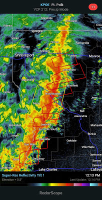
Squall line in Louisiana
yesterday. All the little
red squares you can see
in there are tornado warnings
As expected, severe storms and tornadoes marauded across the South Wednesday, causing damage from Arkansas to Alabama. Meanwhile, a wildfire near Pigeon Forge, Kentucky caused more danger and havoc. 

More on the wildfires in a bit, but the even bigger weather news was the severe weather, which played out pretty much as expected on Wednesday. .. 

Most of the violent weather was along a violent squall line that spend the day traveling from Texas through Alabama. 

It always seems people like me foist a "new" weather term on the public, and we have another one for you.

During Wednesday's outbreak of severe weather in the South, one of the predominate hazards was something called QLCS tornadoes.

It sounds like some weird weather secret code but the abbreviation stands for Quasi-Linear Convective System.

Most of the photogenic big funnel tornadoes you see on the news and in storm videos are borne from supercell thunderstorms. Supercells are rotating thunderstorms that don't have a physical connection to other thunderstorms that might be in the area. They are big, independent suckers. 

 QLCS tornadoes form along a line of connected thunderstorms. The line of storms are usually oriented north to south and the whole line tends to move eastward. 

These lines of storms often have kinks in them, where a piece might try to outrun other storms, or another storm might try to lag behind others. 

When the atmosphere is such that winds change speed and direction with height, tornadoes can form around these kinks or bends in the line of thunderstorms. 

These so called QLCS tornadoes are usually, but not always weaker than the biggies that come from supercells. The QLCS tornadoes often spin up very quickly then die out fast, too, which makes it hard for meteorologists to send out timely warnings. 

Yesterday, there were so many potential spinups that at least 120 tornado warnings were issued. Not all of the rotation in the air that prompted the warnings actually resulted in tornadoes, but it's clear a fair share touched down.

That's especially true in Springdale, Arkansas, around Jackson, Mississippi and southwest of Birmingham, Alabama, where there were reports of quite a bit of damage. 

We have a preliminary count of about 30 tornadoes from this squall line. However, National Weather Service meteorologists will need to go out over the next few days and tease out whether damage in any particular spot was caused by a tornado or straight line winds. 

For instance, if all the trees in a particular area fell in the same direction, that was probably straight line winds. If the trees fell in different directions, that would likely indicate tornado damage. 

WILDFIRES

This has already been a bad wildfire year for the United States as a whole. On Wednesday, a new area was hit. 

At least 35 buildings, mostly homes and vacation cabins were destroyed in a wildfire that roared through rugged terrain around Pigeon Forge, Kentucky. 

Strong winds and dry vegetation helped spread the fire quickly.  Lighter winds and rain today should help. 

Another fire in Gatlinburg, Tennessee prompted evacuations, but firefighters stopped the flames before they reached any homes. Gatlinburg was hard hit in 2016......

VERMONT

As advertised, all this rough weather is pretty much avoiding us. A little mixed precipitation raced through overnight, but didn't amount to anything.

A quick surge of warm air today will probably bring temperatures above 60 degrees in parts of Vermont today, especially west of the Green Mountains. 

Severe storms are possible along the East Coast today.

NOAA's Storm Prediction Center does have a marginal risk of severe storms all the way to the Canadian border in New York State, and as far east as the state's border with Vermont. h Marginal risk means there's a chance of a brief, isolated episode of damaging winds here or there.  

In Vermont, it's possible we'll hear a rumble or two of thunder, and it could get a little gusty under the line of showers and storms as they come through the state tonight, but there shouldn't be any widespread trouble.

Cool and showery weather will return tomorrow, and kind of average weather for early April will continue Sunday through Wednesday at least. 

Wednesday, March 30, 2022

Weird Antarctic Heat Wave Might Not Directly Affect Us, But Scientists Are Freaked Out

Scientists at the Concordia station in Antarctica recently
dressed for the beach as temperatures shattered previous
all-time records for heat. It wasn't the tropical paradise
depicted in the photo. That record smashing high 
temperature was 10 degrees above zero. 
  As frigid Antarctic heads into their even more bone chilling autumn, a strange heat wave earlier this month  has shocked scientists. 

Temperatures on the eastern Antarctic ice sheet were 50 to 70 degrees above normal. Scientists on site even stripped down to shorts and t-shirts or no shirts outdoors to mark the unprecedented event, the Washington Post reported.

The departures from normal were likely the largest recorded on Earth.

It wasn't exactly a tropical vacation, however. This is the most frigid part of the globe and temperatures in much of the area affected by the extreme Antarctic "heat" stayed well below freezing.

For instance, the Russian observatory Vostok, just 808 miles from the South Pole and 11,444 feet above sea level so is frigid. In March, the average high temperature there is a gelid 63 below zero Fahrenheit. In the record heat wave this month, Vostok hit an even 0 degrees Fahrenheit, which shattered the previous March record high by 27 degrees, the Washington Post reported. 

The ever so slightly Concordia Research Station in Antarctica reached 10 degrees above zero during the hot spell, which was the all-time hottest temperature there. The old record was 7 degrees and the normal high temperature in March at Concordia is 56 below, says the Washington Post. 

Remember, this is March, so Antarctica is past their summer, so to speak. 

Still these readings really are unheard of.  For perspective, when we have record heat in Vermont, temperatures are usually 20 or 30 degrees above normal. If temperatures were 70 degrees above normal in Burlington today,  The hottest it's ever been in Burlington is 101 degrees.   

Temperatures in the Arctic and Antarctic often get further above and below normal than in places in the mid latitudes, like here in Vermont. In those places, readings can be 30 or 40 degrees above or below normal with some regularity at the poles.

But 70 above normal is not something scientists have seen. Even at or near the Earth's poles. 

Caused by atmospheric river, a narrow corridor of very warm, wet air that came inland from the Pacific Ocean near Antarctica.   Despite the exceptional warmth, and some rain, it was not toasty enough to cause significant ice melt.  Had this occurred earlier in the Antarctic "summer" the melt would have been worse, the Washington Post notes. 

At least a large portion of this odd heat was probably just a random event.  But it was so extreme that scientists are still very concerned.  Especially since "unprecedented" heat waves keep popping up around the globe. 

Jonathan Wille, a researcher studying polar meteorology at Grenoble Alpes University in France told the Washington Post, comparing an unprecedented heat wave in the northwestern United States and southwestern Canada last June, and the heat wave that just hit Antarctica.  that the heat wave

"...was something that wasn't thought to be possible until it actually happened. It was never observed before, and the atmospheric patterns that led to it happening were just not thought to be possible either until it happens. And that's what's basically happened here over Antarctica."

IT'S COMPLICATED

Antarctica, seemingly a vast, frozen and still place, has a lot of moving parts. With climate change looming,  many of these shifting pieces worry scientists. 

It's not just heat waves that melt Antarctic ice from above that you need to worry about. 

Even if surface areas in large parts of Antarctica stay cold enough such that not much melts, ocean water that is slightly warmer than it used to be can sneak beneath the ice shelves floating on the water and clinging to the edges of the continent. 

This can enable the ice shelves to melt from below, eventually weakening them or even breaking them up.  With the ice shelves out of the picture, glaciers on Antarctica's land are more free to flow faster into the water, where they will melt and raise sea level s globally. 

There's one ice shelf in particular, called Thwaites, that is already showing signs of instability. If it goes, a glacier behind it would move quickly (at least relatively so for a glacier) into the ocean.  If, theoretically just that one glacier were to entirely melt, global sea levels would rise by a little more than two feet. Not good. 

What you might call summer in Antarctica is about to end, and climate scientists might be especially grateful for that this year. 

Sea ice extent around Antarctica reached its lowest level since the first starting keeping track of it back in 1979.

That sounds like a sure sign that climate change is asserting itself, but in the case of Antarctica, not really. Or at least we don't know. 

The Guardian helps us sort out this year's lack of Antarctic sea ice as follows:

"Dr. Walt Meier, a senior research scientist with the NSIDC, said it coincided with strong wins over part of the Ross Sea that had pulled ice to the north, where it melted in warmer waters or was broken up by waves.

This pushed the sea ice extent - the area of the ocean covered by at least 15 percent floating ice - to below the previous record set in 2017. But scientists expressed caution about attributing the retreat to the increase in global temperatures linked to greenhouse gas emissions."

Unlike the Arctic, which has really been losing over the past couple of decades, Antarctica has been all over the place.

Antarctic sea ice extent had been often setting record highs up through 2014, but in the past eight years it's been generally declining.  That's too short a time to conclusively pin the blame on climate change. 

The best that scientists can say is "maybe." According to the Guardian:

"Dr. Will Hobbs, who studies Antarctic sea ice with the Australian Antarctic Program Partnership, said the latest record was significant. There had been an expectation that after the record low of 2017 the ice would recover he said. 

'But now we have these two events in five years that are off the records,' he said. 'You can't say this is climate change, but we do now have to consider whether or not the system is starting to change.'"

The reason why we care about sea ice at the bottom of the world is that it helps keep the massive Antarctic ice cap in place. Lose the sea ice, and the Antarctic ice cap starts melting and sliding off into the sea.  Let that go on too much and global sea levels rise dramatically.  

The sea level is already going up at a faster pace than it did just decades ago and it's going to get fastest yet, and soon, as I reported back on February 15.

So yeah, climate scientists are really interested in what's going on in Antarctica.  There's plenty of research going on. .

Here's an example, according to According to Vox: 

"New research finds that some of the most profound changes to Earth's ice are largely invisible because they're happening far beneath the surface. Land ice and ice shelves are wearing thin from below and it's happening much faster than previously expected."

The chilly air above the South Pole tends to keep ice frozen from above and around its edges. But deep Antarctic waters aren't quite as frigid. 'At a depth in the Southern Ocean, there is a tremendous amount of heat energy below a few hundred meters down' said (British Antarctic Survey geophysicist Robert Larter). This warmer water can then come into contact with the underside of ice shelves, causing them to melt. 

The water in question is barely above freezing. However, if it warms up just a bit, that can make a big difference. 

There's a LOT we don't know about Antarctica, and how what happens there is related to climate change. We do know that what happens in Antarctica doesn't necessarily stay in Antarctica. Yeah, it's a distant, unpopulated place. But with climate change, it's still a place that can come back to bite us. 

Weird Storm Endangers Much Of South Today; Up Here In Vermont, We Escape Big Effects, Again

This is just one forecast model, but all the predictions for
today call for a horrendous line of storms in the South 
that will include straight line winds of up to 80 mph
and the risk of tornadoes. 
 Wildfires, lightning and hail peppered areas of the Great Plains Tuesday, a prelude to a dangerous and in some ways weird weather day for United States today.  

By far the biggest problem today is in a large area centered on Mississippi and extending into surrounding states. 

A squall line was already causing some severe storms in eastern Texas and Oklahoma this morning, and this line will intensify into a powerhouse that you will probably see on the news later today or tomorrow. 

There's already been some damage. I saw news of at least one house burning in Oklahoma due to wildfires from yesterday. And social media this morning has images of what looks like tornado damage in Arkansas.

Usually, afternoons and evenings are the peak times for the most powerful storms, and that will be the case today.  However, ominously, the squall line had already prompted a large tornado watch over most of Arkansas, northern Louisiana, northeastern Texas and eastern Oklahoma early this morning. 

This line will be serious to say the least as it produces a wall of thunderstorms, some with winds gusting to 80 mph or more. Worse, there's plenty of spin in the atmosphere to stir up tornadoes, some of which might be strong and long lasting this afternoon and tonight. 

As the National Weather Service office in Jackson, Mississippi notes, there might not be as many tornadoes as during last week's outbreak of dangerous weather. But more people will be affected by damaging storms due to the expected nearly solid line of storms bearing powerful straight-line winds today. 

One weird aspect of this system is the strong winds out ahead of the squall line.  It's usually breezy ahead of these things, but this is more intense. Winds in and near Mississippi could gust to 60 mph well before any thunderstorms pester them.

They'll have scattered tree and power line damage hours before any storms make things exponentially worse.  

A large area of the South remains under a risk of
very severe thunderstorms and tornadoes today.

Further north, in the central Appalachians, strong winds will create a fire hazard today as forests haven't leafed out yet.  Strong March sun has dried the forest floors, so the winds today could stir up some fire trouble. We also see a nasty risk of wildfires in Florida, southern Texas and along the western Texas/Oklahoma border.

In Michigan, it's the opposite problem.  An ice storm is ongoing in northern parts of that state, just to keep the weird motif of the entire storm going. 

Tomorrow, there's a lower risk of severe weather but some thunderstorms could cause damaging winds in New York, Pennsylvania, New Jersey, Maryland and Virginia. 

VERMONT EFFECTS

As has been the case with so many storms lately, the Green Mountain State will lead a charmed life with this expansive storm system.  In other words, it'll affect us, but just not all that badly.

It was nice and clear, but cold early this morning. Most of us were in the teens at dawn, but perennial cold spot Saranac Lake, New York was at a big fat 0 degrees.

You'll see it cloud up pretty quickly today, and by evening, there could be a little light snow, rain, or mixed precipitation coming in.  That'll be a warm front that will race through overnight. 

When you get up tomorrow morning, it will suddenly be much warmer than it's been, especially if you're west of the Green Mountains. 

It'll be a warm-ish breezy to windy day Thursday with highs near 50 east and the upper 50s west. There could be a few showers around, but I think most of the day will be dry until you start getting into the late afternoon and especially evening. 

Showers, some possibly with brief downpours will come through with a cold front Thursday night.  We could even hear a few rumbles of thunder. 

Then, from Saturday onward into the middle of next week, we end up with near average weather for this time of year. Saturday might be a little on the cool side, but it won't be nearly as cold as we just had.  Highs in the 40s doesn't sound awful, does it?


Tuesday, March 29, 2022

Wildfires And Severe Storms This Week Are Following Concerning Trends

Wildfires just keep getting worse in the central and 
southern Great Plains. Fire activity is forecast to get
intense later today. 
 Northern Texas, western Oklahoma and southwestern Kansas are under a rare alert for "extremely critical fire conditions" today as yet another round of wildfires are bursting their way through the central and southern Plains. 

Meanwhile, the Gulf Coast states are gearing up for a big severe thunderstorm and tornado threat tomorrow. Both of these issues are part of a worrying trend. 

WILDFIRES

Extremely critical fire condition alerts are usually only issued 10 or so days per year somewhere in the nation.  This is the second time already this year that parts of Texas have been under this threat. This threat level means that dry conditions, very low humidity and strong winds would make any wildfires that start pretty much impossible to contain. 

In the "extremely critical" area today, fires were already spreading before weather conditions were expected to get dangerous. By dangerous, we mean a landscape parched by drought, bone-dry humidity and winds of 35 to 40 mph with gusts in the 65 to 70 mph range 

As of this past Friday, 123,000 acres in Texas had already burned this month, more than the three previous Marches combined, according to Texas Tribune.

The Texas fires this year have already caused one death and burned several structures.

Fires are already burning today in Oklahoma as well. A grass fire that started at an Oklahoma City salvage yard threatened several homes in the city. At least 10 of the houses were evacuated, but it looks like firefighters managed to save them. 

Earlier this month, a firefighter died while fighting a rangeland blaze elsewhere in Oklahoma. Several other wildfires this month have raced through mostly open country in North Texas, Oklahoma and Kansas. 

As is so often the case, climate change seems to be helping to create an increasing trend of winter and spring wildfires in the Great Plains. Drought has become more endemic, and hotter weather than in the past dries things out faster. 

This has been known since at least 2017, when a study indicated that the number of large and dangerous wildfires in the Plains tripled between 1985 and 2014. 

It isn't just climate change causing this, of course. Farm abandonment is one reason.  If farmland is left alone, flammable weeds take over. Also, invasive species like a variety of cedar that burns easily and hot are probably increasing the severity of at least some of the fires.

TORNADOES

Notwithstanding last week's storms in Texas, there's been a trend toward lower numbers of tornadoes in the traditional "Tornado Alley" in the Great Plains.  The new tornado alley, if you will, now seems to be further east, in the Gulf Coast States, and the Mid-Mississippi and Tennessee River valleys. 

Once again, the Gulf Coast states are under a serious
risk of damaging thunderstorms and tornadoes, 
with most of them happening tomorrow. 

True to form, after a chance of a few tornadoes and severe storms today in a band from northeast Texas to southwest Iowa, tomorrow looks dangerous again in the Gulf Coast states. 

If things work out as expected the outbreak of severe storms and tornadoes centered in and around Mississippi won't be those classic individual supercell storms dropping large, wedged-shaped tornadoes.

Instead, most of the rough weather will consist of an intense line of storms, with damaging straight line winds of 75 mph in a few spots, along with embedded tornadoes swirling within the main line. In some ways, this type of tornado is more dangerous than "traditional" tornadoes with well defined funnels.

Tomorrow's anticipated tornadoes will be quick hitting and hidden behind walls of heavy rain, so nobody will be able to see them coming. Even though radar will pick up the tornadoes and the National Weather Service will issue tornado warnings as needed, there's something about human nature that needs visual confirmation that the twister is heading toward them.  There will be no such visual confirmation in most cases tomorrow. 

Research has confirmed the tendency in recent decades of more tornadoes in "Dixie Alley" and fewer overall in the Great Plains. 

The number of times the atmosphere is conducive to tornado formation is actually increasing pretty much everywhere east of the Mississippi River, including here in Vermont. (But don't worry too much, tornadoes will remain rarity in the Green Mountain State. 


Chaotic, Near Record Cold In Northeast Gives Way To Big Changes

Massive, fatal pileup on Interstate 81 in Pennsylvania
due to unseasonable cold and snow squalls in the Northeast,
including here in Vermont Monday. 
Winter certainly left its mark on the Northeast on Monday with near record cold, snow, garden and crop damage and at least one terrible highway pileup. 

Next up, temperature gyrations and a brief visit to spring, followed by March weather as we begin April. Confusing, yes, but that's spring for you. 

Let's go over Monday first. When very cold blasts of air hit us in the spring, the weather can get weird, and sometimes dangerous, which was the case here.

Around Vermont, the snow showers weren't that heavy, but the fine flakes would often briefly cut visibility to risky levels if you were out on the highways. Worse, the weak March sun would come through and melt snow on the roads, and then it would re-freeze when the clouds thickened up at times. This was especially true on bridges and overpasses

I'm surprised there weren't more crashes in Vermont than there were. But that's a goo thing. 

That wasn't the case in other areas further south and closer to the Great Lakes, where snow squalls were added to the mix. This led to a terrifying pileup on Interstate 81 in Pennsylvania. The video in this link is probably the scariest pileup video I can recall seeing. 

Unfortunately at least three people died in the pile up and 24 others were taken to hospitals.  The death toll could rise because as of this morning the wreckage was so extensive crews had not gone through it all yet.  Nearly 24 hours after the crash, the Interstate was still closed.

While Monday wasn't exactly unprecedented in the weather department, it was still something given how otherwise mild this March has been. Montpelier only reached a high of 19 degrees on Monday, tying the record for the lowest high temperature for the date. 

Since it was an early spring in the Northeast, garden plants and orchards were already starting to sprout.  

I think Vermont was far enough north so that any early daffodil and other perennial shoots that were up when the cold hit will survive. 

New daffodil shoots in St. Albans, Vermont looking pretty
frozen after such unusual late March cold in Vermont.
They should recover, fingers crossed! 

Down in southern New England and the Mid-Atlantic States, there was damage to decorative cherry tree and magnolia blossoms.  I THINK blooming daffodils down that way will manage.  Orchards aren't blooming yet in places like Pennsylvania and New Jersey so things should be OK 

As cold as Monday was, we can always come up with incidents when it was worse, if we want to feel better about things. 

I was able to find examples of worse cold than what we just endured even later in the season.  A couple of April 7s in fairly recent history stand out. 

The modern gold standard of springtime cold and wintry weather would be April 6 and 7 in both 1972 and 1982.

Back in 1972, Burlington recorded its all time coldest temperature with a lovely 2 above zero. It won't get that could in this little late season Arctic outbreak. It was 2 below that day in Enosburg Falls, and 39 inches of snow was still on the ground at high elevation Peru, in southern Vermont. 

It didn't even warm up much after that cold shot in 1972. Montpelier never got any warmer than 54 degrees until April 30. 

In 1982, central and southern New England and New York experience a blizzard on April 6-7 and temperatures fell to previously unheard of levels for that late in the season. 

Burlington's high and low temperature on April 7 ,1982 was 26 and 13 and that was one of the warmer spot. Down in Worcester, Massachusetts back in 1982's winter redux, the high was 21, the low was 11 and 15 inches poured down on the city. That would be fairly wild in January, never mind April! 

NEXT UP

 It's still very wintry out there today, but we hit rock bottom yesterday and still should climb back toward spring.  It'll be slow process at first, then we'll have a brief burst of full-on spring before temperatures quickly retreat again. 

Most of us will stay below freezing again today, but it will still be a little warmer than Monday. I know that's not saying much, but whatevs.. 

 Frankly, today won't be much better than Monday was. Sure, it will be almost ten degrees warmer than Monday, but that's saying basically nothing.  A high around 30 is not the way to impress at the end of March. 

It'll be a little chilly for the season but even better Wednesday when it gets up to 40 degrees or so. We have one little slap of winter to go with a bit of snow and mixed precipitation Wednesday evening when a warm front approaches.  But it won't amount to much. 

The warm front will pave the way for a strong but brief surge of very mild air on Thursday.  Especially west of the Green Mountains, the air will take on an almost humid feel as actual temperatures approach 60 degrees. It will be somewhat cooler east of the Greens.

Unlike the expected storm chaos in the South and Southeast with this system, we should have some showers and perhaps a rumble of thunder up in our neck of the woods.  (I'll have a separate post today on the extreme wildfire threat in the Plains and tomorrow's expected severe weather in the South).

After that, we get into a similar weather pattern we just had. The difference is the dip in the jet stream that will cause the cool, possibly showery weather over the weekend won't be able to grab Arctic air from the North Pole.

So it will only be sort of chilly, with those scattered valley rain and mountain snow showers Friday and into the weekend.  Highs in the low to mid 40s sound a lot better than teens, so we'll take that over the weekend.  

Monday, March 28, 2022

Another Cycle Of Fires, Wind, Tornadoes, Winter Weather Underway In U.S.

There might not be another destructive tornado in New
Orleans like last week, but the U.S. faces another week
of varied weather hazards through this week.
 After a lull lasting a few days, another big, lumbering storm is beginning its move across the nation, promising another round of just about everything imaginable.  

Up here in Vermont, the evolving pattern means kitchen sink weather this week. Meaning a little of everything, except the kitchen sink, but no guarantees on that. More on Vermont conditions in a bit.   

The kitchen sink weather isn't limited to Vermont. It's the whole nation, almost. 

Spring time is when we're most likely to see a wide variety of weather hazards and this spring is so far showing how true that is. 

WILDFIRES

The trouble started Sunday, well ahead of the storm. 

Wildfires are already breaking out once again in the warm air ahead of the system approaching from the Pacific Ocean.  This is continuing a trend of unusual wildfires this winter and early spring. 

A wildfire broke out near Boulder, Colorado over the weekend, right near the National Center for Atmospheric Research. 

Around 8,000 homes involving 19,000 people were evacuated because of this fire.  Thankfully no houses ended up seriously damaged. At least so far, as this wildfire is still burning. 

The area around Boulder is at the moment especially sensitive about wildfires after a blaze in late December burned about 1,000 homes. It was the worst wildfire in Colorado history. 

More fires broke out in Texas Sunday and those are forecast to increase today and tomorrow. It's been a rough year in places like Texas and Oklahoma as repeated wildfires have caused numerous evacuations, destroyed homes and ranches and killed at least one person.  

Still dormant vegetation, a long, intensifying drought, dry, strong winds and low humidity will ensure more fires today and tomorrow. 

TEMPERATURE WEIRDNESS

In some cases, the warm air in front of this evolving storm was downright hot. Las Vegas reached 93 degrees Saturday, the hottest day on record for the entire month of March. Death Valley, California also set the record high for the entire month of March with a reading of 104 degrees.

Record highs for the date including 79 in Salt Lake City, 87 in El Paso, Texas, 70 in Pocatello, Idaho and 84 in Pueblo, Colorado.

The buildup of warm air in the western and central North America has caused a corresponding dip in the jet stream over the Great Lakes and Northeast, as we well know.  It's frosty this morning in the Carolinas as a result, it's snowing around the Great Lakes and everybody has dug out their winter gear again. 

RAIN AND STORMS

The actual storminess made landfall in California Sunday night. Southern and central California are expecting the biggest storm since late December. Which unfortunately isn't saying much. 

After a very wet December, the rain and snow shut off in California in January and February, which is normally the peak of the wet season. Snow didn't build up in the mountains as it should, and low elevations dried out again. 

This storm will help,. but it's too little, too late.

The system will skip over to the east and redevelop in the central Plains tomorrow, then strengthen as it heads toward the Great Lakes by Thursday. 

This will set up a stripe of severe storms and possible tornadoes in Texas Oklahoma and Kansas tomorrow. The severe outbreak will peak Wednesday in the Gulf Coast states with more destructive storms and tornadoes.

The area in play for the greatest chances of tornadoes and severe storms Wednesday is almost identical to the area most affected by severe storms and tornadoes last Tuesday, including that destructive tornado in the New Orleans area

Thursday, the severe threat moves to the Middle Atlantic States as far north as New Jersey, which is unusually far north and east for this time of year.  

This whole storm system will probably also stir up a pretty decent winter storm in northern Minnesota and the northwestern Great Lakes. 

VERMONT IMPACTS

Hard to tell for sure, but web cam image of Interstate 89
bridge over Lamoille River in Milton looked icy.
Bridges and overpasses are especially troublesome today
The storm that will cause all this interesting national weather will, as I hinted at, give indirectly and directly give us a variety of weather the rest of the week. 

First, Snow, Cold

That dip in the jet stream I referenced above allowed the weather gods to grab a packet of Arctic air right from the North Pole and blast it down on us in Vermont today.

Um, yay?  

Temperatures were pretty uniform across Vermont early this morning, generally in the low to mid teens, with wind chills right around zero. It's actually a bit cooler than many of the already bone chilling forecasts had indicated.

There's still some disturbances rotating down from Canada in this air flow, so snow showers will continue off and on all day, especially in the central and northern Green Mountains. 

This is making some roads surprisingly slick this morning, or just giving motorists surprises. I was checking Vermont Agency of Transportation web cams this morning.  The ground temperature is relatively warm from the recent balmy weather. 

Narrow bands of heavier snow could develop here and there
today amid the cold snow flurries. Radar detected one such
band near Alburgh around 8 a.m. this morning and
this Vermont AOT web came along 
Route 78 in Alburgh seemed to confirm it. 
So in some spots, the light snow is partly melting.  Then re-freezing.  Or bridges and overpasses offer surprises As of 7 a.m. the traffic cam at the Lamoille River Bridge on Interstate 89 in Milton showed the pavement looking clear before and after the bridge, but the roadbed on the bridge itself looked really icy. Be careful! 

Since the snow showers will continue all day, and might actually increase a little this afternoon, the trip home could be a little interesting, too.

Not much snow will fall in the valleys, probably an inch or less additional, but a few more inches are likely in the already suddenly snowy central and northern Green Mountains. 

Highs today will only be 15 to 25 degrees, which for many of us will be near records for lowest "high" temperatures.  

Then what?

After a similarly frigid night tonight, a warm up will start. Sort of. Tomorrow will only get up to the low 30s, still way colder than normal for this time of year. 

It'll be a little better Wednesday afternoon as clouds increase, but it will still be a chilly 40 degrees.

From there we might have, yes, a little more snow or mixed precipitation Wednesday night with a warm front. 

Then, with the storm going by to our west, we'll have another temperature  swing upward - well into the 50s for most of us.  Don't get used to that, though.

Temperatures go right hack downhill next weekend.  It won't be nearly as bad as today is, but Thursday's foray into spring will be brief.  It'll only be in 30s and low 40s again for awhile after Thursday or possibly Friday.

They say April is a cruel month, and there you go, at least if that forecast is accurate.

Sunday, March 27, 2022

Yes, This Year's Mud Season Is Worse Than Usual In Vermont

On Vermont's dirt roads, and in our own yards, like this
photo of my boots deep in the muck in St. Albans,
this has been quite a mud season
 Everybody's been talking about it. 

The thick, oozing, tire and boot sucking seemingly bottomless mud in Vermont this month.  

The mud gods seem to have conspired to give us a particularly nasty mud season.  Nobody is especially happy about it, except maybe tow truck drivers. And even there, I have my doubts about their level of glee.

You can't do much about the mud, really, so we just complain about it. And hope for a nice patch of dry, warm weather to solve the problem. Good luck with that. 

We all chuckle at the mud, of course, but it's potentially dangerous. If there's an emergency on one of those rutted, mired roads, how are you going to get a fire truck or an ambulance up there? What about some 85 year old who lives on such a back road? They can't drive in that, and nobody can reach them. What do you expect our elderly friend to do? Hike five miles to the store over on the paved road then haul his load of groceries the five miles back home?

VTDigger reports that some communities have ATVs at the ready to respond to emergencies in mud-bogged areas.

WHY SO MUDDY?

Several factors dating all the way back to January conspired to leave us bogged down in the muck.

It didn't really snow all that much this winter, so there wasn't much of a protection to keep the ground from freezing.  January was cold, the nippiest month since February, 2015 and the coldest January since 2009. 

We had a large number of particularly cold, subzero nights, which really helped drive the frost deep into the ground.  Banana Belt Burlington had 17 days that were at or below zero in January, for instance. 

February was much warmer, with several balmy spells. The upper few inches of gravel on roads did thaw, but the warm spells were accompanied by rain which saturated things even more before they re-froze. Several bouts of sleet and freezing rain throughout the winter didn't help, as that ice from the sky hermetically sealed the frozen ground to wait for a real, sustained thaw. 

Then March hit. It's been a warm month, so the thaws began in earnest. That really accelerated the melting, quickly turning the upper levels of gravel to sludge.

Most critically, we had long spells in which a string of consecutive nights stayed above freezing. 

If you want both a great maple sugaring season and a not-so-bad mud season, you want dry, sunny, breezy days that get up above freezing in the afternoon, then below 32 for at least several hours at night. 

In that freeze/thaw weather regime, the roads do thaw and get muddy. But the warm March afternoon sun and the dry breezes tend to make things less mucky. The overnight freezes harden up the muck. The end result is a gradual ground thawing, and the ruts don't get that deep on those gravel roads

This year, we had periods in which afternoon temperatures that spiked into the upper 40s to mid 60s, making things melt fast. We had strings of overnight lows above freezing, so the mucky roads would never have a chance to harden up and some of the moisture to evaporate. 

The result was the mire we're living with. Check out the descriptions and photos in VPR's Brave Little State for just a taste of it all, in case you somehow feel left out. 

WHY MUD IS LINGERING 

The ground thaws from the top down. When there's a thick layer of frozen ground, the mud lingers on top because the water can't percolate deeper into the ground. The frost below blocks it. Things only improve when all the layers of the soil thaw out. There's not much relief until that happens.  

The current weather is about to make things worse. Or at least prolong the misery. 

Temperatures will fall below freezing later today and stay that way for most of us until Wednesday afternoon. This will give the ground a chance to re-freeze. The ground will certainly not refreeze to anywhere near the depths it froze back in those subzero nights in January.  

But a thin layer will re-freeze, then thaw again once it inevitably warms up later in the week. Meanwhile, the ground several inches below the surface hasn't thawed yet, and that will have to wait until we see more spring weather. 

As VT Digger reports, climate change could make mud seasons trend worse.  Less snow accumulates in the winter than in the past, allowing the frost to bore deeper into the ground, as it did this year. 

VT Digger also came up with something I surely hadn't thought of, but kind of makes sense. Thawing comes sooner, so mud season comes sooner. Mud season usually firmly comes to an end when trees bud and bloom, because those reawakening trees draw moisture from the ground, drying it out some. 

Trees are leafing out a bit sooner, too, but not by much, since factors other than warmth, like sunlight are at play for plants. This means there's a longer wait from the time the thawing starts to the time trees leaf out. That would mean a longer, potentially more intense mud season.

All good things come to an end, and so do most bad things. It will dry out eventually, and perhaps by the end of the month, we can actually drive down Vermont's gravel roads once again. 

Saturday, March 26, 2022

Upcoming Cold Snap To (Slightly) Revive Ski, Maple Sugaring And Mud Seasons

Back to the National Weather Service/South Burlington
snow prediction map after a long break.  Light snowfalls
are expected as a late season cold snap comes in, but the
mountains could pile up several inches of snow at least
between now and Monday afternoon
 Many of us here in Vermont are into spring weather, but are always ready for the inevitable disappointments. 

As advertised, spring is going on hiatus starting tonight.  It will stay away for a few days, but never fear, it will return. Eventually. 

There's been remarkably little snow on the ground this month, considering we often receive large snowstorms in March. The ground has been continuously snow-free in Burlington, for instance, since St. Patrick's Day, which is unusual.

By tomorrow, though, the ground will once again be snow covered. In the valleys, it won't be much, with most of us expecting one to three inches, with less in the Connecticut River Valley. 

The set up, though, favors what might be a decent snowfall in the central and northern Green Mountains through Monday. 

That Arctic front is still due to come through Sunday.  Ahead of it, it will be cold enough for some wet snow in most places and the mostly light snow will continue through much of the day.  With sharp northwest winds blasting, the western slopes and summits of the Green Mountains will see a more enhanced snowfall. Which will last there well into Monday.

Current National Weather Service forecasts have isolated amounts of up to six inches of new snow in the Green Mountains, which isn't odd for this time of year, but still a noticeable addition of fluff in this snow-starved year. 

I actually think some favored places might receive more than that six inches of snow by Monday afternoon. I'll go out on a limb and say there's a chance super favored places like Jay Peak and the Mount Mansfield summit could come in with a foot of snow. 

This will freshen up the ski slopes for a little while. 

It's going to be wicked cold, though, for this time of year. Things will freeze up really solidly out there again, as we'll have two nights of temperatures in the 5 to 15 degree range, with highs Monday only in the upper teens in the cold spots and mid-20s in the banana belts. 

This substantial cold will probably recharge the maple trees for more sap runs, but I have to wonder if it's too late for places like southern Vermont lowlands and the Champlain Valley.

It's been a very warm month, with too many nights that stayed above freezing.  I'll have to research this more, but I wonder about the quality of the sap coming from the trees right now in the warmer spots. It could be at least partly a season of lower grade (but still delicious!) maple syrup. 

Still, I think the cold snap will add a little new life to sugaring season.  

It's also been a hell of a mud season, which I'll have more on in an upcoming post. In some places, the mud has gotten a little less bad as more of the frost comes out of the ground.  This cold wave will freeze things back up.  Obviously, the frost in the next few days won't go as deeply into the ground as it did during the subzero spells of January.

It will prolong mud season, though.  Newly frozen ground will have to thaw again later next week when it warms up.  

We'll ruefully be singing that Brad Paisley song "Mud On The Tires" for a while longer, for sure. 

Friday, March 25, 2022

A Rude Interruption To Spring Is Coming For Us On Sunday

Person in this photo looks glum, probably because we're
going to sink into another period of winter cold 
Sunday through Tuesday
 Yesterday, I waxed poetic of sorts to the fact that springtime in Vermont comes earlier than it did decades ago due to climate change. 

I also noted wintry interruptions to these early springs also seem rougher than they once did. 

Case in point will be Sunday through Tuesday, with a quick shot of Arctic air arriving to remind us we live in the North Country. 

Though particulars of the forecast might change a bit, many parts of Vermont should get a couple or even a few inches of snow. Worse, temperatures will plunge to mid-winter levels. 

Here's the particulars:

We're starting this Friday morning relatively mild and rainy.  Mostly cloudy and seasonable air will linger through Saturday with scattered light showers here and there. Nothing to get excited about.  

On Sunday, the Arctic cold front arrives. A sort of, kind of mild start to Sunday will wilt under increasing northwest winds, and temperatures will probably fall during the day.  Snow showers will whiten the ground in the valleys. 

In the mountains, snow showers will stay pretty consistent through much of Sunday night, accumulating to several inches.

The real story will be the wind and cold.  The warmer "banana belt" towns will drop into the teens Sunday night. The colder towns will be in the upper single numbers. 

Highs on Monday will only reach the low to mid 20s for most of us. Strong northwest winds will continue from Sunday through Monday evening.  That will lower wind chills to at or below zero

There is nothing springlike about that forecast!  On the bright side, Monday will quite likely be the coldest day until late November or December. 

As harsh as the cold snap will hit, we probably won't have many record low temperatures. Around this part of March in 1923, we had quite a cold snap.  The record low of 5 below set that year for Monday in Burlington won't be challenged. Neither will the record for the coldest high temperature for the date, which was 13 degrees in 1923.

The records don't go back as far in Montpelier, so the Capital City does have a slim shot at setting a record for the coldest high temperature for the date on Monday. The current record is 19 degrees. The record low max temperature in St. Johnsbury is 24 degrees, so that's in play, I suppose.

Lots of us have daffodil shoots and other perennials just starting to come up.  These early plants do have a natural antifreeze in their system, so they should mostly survive this. 

Though the overall weather patter does not look super warm after this cold snap, things will improve.  We'll be closing out March and heading into April after all, so you can't sustain cold weather like we could a month or two ago. 

Next Tuesday should still be cold, with lows in the single numbers and teens and highs in the 30s. But it will probably warm at least temporarily to normal levels again by next Wednesday or Thursday. 

Thursday, March 24, 2022

Teen In Now-Famous Tornado Pickup Truck Video Is Fine, And Cool As A Cucumber

The driver of the red pickup truck in that viral tornado video
this week is Riley Leon, 16. As you can see in this 
smiley photo from KHOU, he's fine. 
UPDATE:

The only truly bad news in the story below, which I posted yesterday, was that Riley Leon's beloved truck was written off by the insurance company as a total loss.

Obviously it was still drivable, but the dents scratches and broken glass from the tornado left it in ruins.

The truck had been a family workhorse for at least a decade.  

The bad news is now a thing of the past, too. As Jalopnik reports:

"Chevrolet partnered with local dealer Bruce Lowrie Chevrolet in Fort Worth, Texas. He's getting a brand new 2022 Chevrolet Silverado 1500 LT All Star Edition - a truck that regularly goes for over $40,000 a pop. Chevy is also donating an additional $50,000 to aid the American Red Cross disaster relief efforts in Texas."

Let's just hope Riley Leon doesn't take up storm chasing with his new truck. 

PREVIOUS DISCUSSION
 
 There's been a viral video by Brian Emfinger circulating this week of that red pickup truck getting caught in a tornado along a highway in Elgin, Texas.  

As I noted the other day, the video show the tornado flipping the truck on its side, spinning it a couple times while still on its side, then violently plopping it down on its wheels. 

Meanwhile, power lights arc and explode all around. The driver inside the truck then seems to casually drive away from the swirling metal roof sheets, debris and dirt.

Local media in Texas inevitably tracked down the driver. He is Riley Leon, age 16. Among the television stations scoring an interview with Leon was Fox 7 in Austin. 

The kid says he's fine, both physically and emotionally. He's got a few minor scrapes and cuts on his left arm, and he's philosophical about what happened. "Life keeps going on and we cannot let ourselves get down because of a single problem," Leon said. 

Leon said knew dangerous weather was in the forecast Monday, but he didn't want to miss a job interview at Whataburger. However, he said he never expected the tornado to be at the same moment as me and at the same place.  

Still image of the viral video of the red pickup truck
caught in the Texas tornado, highlighted here so you can
see it better. The 16 year old boy who was driving the
truck is fine. 

He had missed a U-turn, but he found the next one and began using that when the tornado hit.  He told Fox 7 the experience was like this: 

"I was driving normally, seatbelt on, hands of my driving steering wheel......and I was going to take the U-turn. I felt my truck lift up and it took me to a ditch, and put me on my side and spin me out and that's where spinning into the road and it got on its four wheels and the video shows that I kept driving, but actually I just drove off. I drove out of the road to not cause more accidents"

Two things here that are cool:  First, he was wearing a seat belt, which I'm sure prevented Leon from being seriously injured or even thrown from the truck. Second, I'm impressed that the logic for him driving away is he didn't want anybody to collide with him, causing a bigger problem.  

He stopped down the road and a brown van pulled up, and the van's occupants asked  Leon if he was OK. At this point, he was undecided as to whether to just drive home or get help. He'd lost his phone in the chaos, so the people in the brown van let Leon use their phone to call his parents. 

Leon said he learned his lesson about driving when the weather is forecast to become dangerous. "The number one rule, the number one thing I learned was if there's going to be bad weather, stay home. No matter, no matter how important the thing is to you, stay  home. Your life, your life matters more than other stuff."

The teenager say he is bummed the truck seems to be destroyed, since it had been in the family for years. His father had recently sold it to him. On the bright side, Emfinger's video will be excellent proof to provide to his insurance carrier. 

Remarkably, the 11th grader went back to school on Wednesday. Everybody at school is calling him "Tornado Boy."  Oh, and he got the job at Whataburger. He starts Monday.  

Here's news video with Leon from television station KVUE with additional details. It also includes the Brian Emginger clip of the truck and the tornado. If you don't see the video displayed on your device, click on this hyperlink:


Feeling The Season Way Ahead Of Schedule Agaiin

Really early for this. Yesterday, March 23, I got to work 
expanding a perennial bed while daffodil shoots 
were poking up nearby. Springs in general do seem
to come a lot earlier than they used to.
 This is anecdotal, but honestly, spring keeps coming so much earlier than I remember as a kid in Vermont. 

The setbacks to the season seem harsher as a result, but there's no denying spring ain't what it used to be  - like in my childhood memories of spring in Vermont during the 1960s and 1970s. 

I was out in my yard in St. Albans, Vermont yesterday. What I was seeing was probably what right about April 10 looked like a few decades ago. It certainly didn't seem like March 23. 

Lots of early perennials were poking up, some already two inches or so tall.  The yard was completely free of snow and the grass in protected corners seemed to have a new sheen of green.  Robins were engaging in ongoing turf wars. The ooze from mud season was just starting to ease a bit. I was actually able to begin work on expanding one of my flower beds. 

I have no illusions it will just be flowers and butterflies and warm breezes through the rest of the season.  Brief excursions back into winter are inevitable, and are in the forecast. (Mondays lows should be in the low teens, highs in the 20s. Brrr!) 

Some springs are, and will always be warmer or colder, earlier or later than others. We'll even have a daily record low temperature here and there, though those are, and will be more rare than record highs. 

Spring, in general, is warmer and earlier than it once was.

I might eat my words, but we'll probably never again have an April like 1972, when only five nights in Burlington stayed above freezing and it got as low as 2 above, still the coldest reading for April on record.. (For comparison, so far this March, nine nights remained above freezing in Burlington).

We also, thankfully, probably will never have a May like 1966, when 11 of the first 14 days of the month saw subfreezing temperatures. 

I wonder, though, what the next weirdly warm spring month will look like.  Will we outdo March, 2012, when we had a week of temperatures in the 70s and low 80s? 

Will we someday have some of the first leaves on the trees in early April?  When I was a kid, the first trees to turn green didn't do so until early May. Now, that usually happens around the third week of April, at least in the banana belt Champlain Valley. 

Sometimes, global warming is referred to as "global weirding."  The extremes get, well, more extreme, or at least more odd.  We've certainly seen that in recent Vermont springs.

In late February, 2017, we saw temperatures in western Vermont reach the low 70s, far higher than anyone had seen so early in the season.  Then, two weeks later, the Pi Day Blizzard dumped close to three feet of snow on those same "mild" towns. 

On April 9, 2019, I saw trees around my  yard sag under the weight of freezing rain. In 2020, another warm spring was interrupted by a snowy Mother's Day.

Last year, spring was way early, with flowers blooming all around my yard on April 20.  By April 21 and 22, five inches of snow had smushed the flowers into the ground and blinding snow squalls swirled around my house.  Two days later, it was warm, snow-free, as if nothing wintry ever happened.

All these changes of course have far broader implications than me just saying "Gee whiz'" to myself in the gardens. 

This is another screwed up maple sugaring season. It started early, but I'm not sure all sugarmakers were ready for it in February.  Then a long warm spell last week probably at least deteriorated the quality of the season, at least for some producers.

Early springs lead to premature blooming of apple trees and grape vines and such. Those crops end up vulnerable to late frosts, which still regularly interrupt these milder springs. 

I've always been particularly in tune with nature, the change of seasons, how the landscape changes day to day.   At the risk of having my Vermont card revoked, winter isn't necessarily my favorite season. The honors go to spring.

The weird springs give me mixed emotions, but most of those emotions are tinged with misgivings. Sure, who doesn't love hints of greenery in a Vermont garden in mid-March?  But then you worry the flowers are coming up too soon, and will get wrecked, like my too-early lilacs did during last April's brief snow and cold.

Flowers around my house are the least of anyone's worries, including mine. Climate change is now affecting everyone.  It will hit is harder in the years to come. How hard is too hard?


Wednesday, March 23, 2022

New Orleans Slammed By Tornado; Up Here In Vermont, We Gear Up For Some Late Season Ice

Television viewers in New Orleans were horrified to 
see this on their TV screens last night. 
 One of the last of the tornadoes in a two-day outbreak in the South proved to be the worst.

A tornado roared through New Orleans last night, killing at least one person, injuring others and leaving behind a trail of extensive damage. 

The tornado went through New Orleans' Lower 9th Ward, and through parts of St. Bernard Parish.  The community of Arabi seemed hardest hit. Those are neighborhoods that especially didn't need this. These are mostly mid to low income neighborhoods that were also largely destroyed during Hurricane Katrina in 2005. 

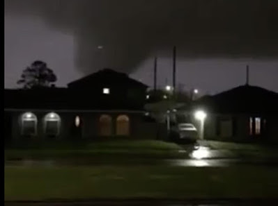
Local television stations showed live video of the tornado, which consisted of a large gray, wedge shaped funnel crossing the city. Other video, taken closer to the tornado, depicted a loud roar, debris in the air and bright blue flashes as power lines and transformers collapsed in the winds. 

Virtually no house in New Orleans has a basement, so people had to cower in bathrooms and closets in hopes of avoiding injury or death from the twister. 

The extent of the damage was a bit hard to quantify in the darkness of night, so there will be better assessments with daylight today. It is clear that numerous houses were either destroyed or badly damaged. 

NOLA.com said rescuers were hampered by debris covered streets, power outages and natural gas leaks.

The New Orleans tornado further destroys the myth that damaging tornadoes can't hit cities.  They do, both in and out of so-called "Tornado Alley"

A partial list of cities hit by destructive and deadly tornadoes over the past decade or two include Oklahoma City, St. Louis, Nashville, Atlanta, Fort Worth, Salt Lake City, Sioux Falls, Raleigh, Brooklyn and Queens areas of New York City, Springfield, Massachusetts and Ottawa, Canada. 

The New Orleans tornado last night was one of 70 or so tornadoes in the South over the past two days, according to preliminary reports. 

Some more severe weather, including possibly a few more tornadoes, are on tap today in the Southeast and in Ohio. 

After today, forecasters think there will be a lull in severe weather for about a week before new storm systems entering the middle of the nation next possibly touch off more dangerous weather.

VERMONT ICE

Springtime in Vermont is about to go on hiatus, as it often does in late March and early April.

Yes, we can get freezing rain in the spring. This photo shows
ice accumulating on trees in St. Albans, Vermont on April 9,
2019. Similar scenes are possible in parts of Vermont tomorrow.
The forecast includes freezing rain, sleet, cold rains, eventually snow and a shot of wintry air.  

The parent storm that helped cause those southern tornadoes is finally headed our way.  After this morning's chill, you'll notice it clouding up today, and a bit of trouble will arrive overnight, mostly after midnight. 

A winter weather advisory is up for all of Vermont except the Champlain Valley tonight and tomorrow morning. 

Mixed precipitation will overspread Vermont overnight.  It won't come down super hard, but it will be enough to coat untreated roads and sidewalks with ice, so tomorrow morning's commute could be a toughie for some of us. 

The ice won't get thick enough to damage trees or power lines, except possibly in a few isolated spots in the southern Green Mountains where ice could accumulate up to a quarter inch in thickness. 

The Champlain Valley is expected to stay slightly warmer, so there it will be mostly a plain, cold rain there, perhaps mixed with a snowflake or ice pellet here and there. 

Temperatures will slowly warm up tomorrow, so most of us will go over to plain, cold, light rain during the day tomorrow. Winds could also get gusty for a time along the western slopes of the Green Mountains tomorrow morning. 

Rain will continue Thursday night, with perhaps a bit of a mix in the mountains.  Scattered showers of rain and snow continue Friday and Saturday before, yup, a nice sharp Arctic cold front arrives Sunday. That front should produce at least a dusting of snow, with maybe a few inches up in the mountains. 

That'll get us right back into winter. It'll get down into the upper single digits and teens for lows Sunday and Monday nights, and it won't even get above freezing Monday afternoon.

As is typical with these late season cold shots, it won't last all that long. A slow but real warmup will start next Tuesday.