Tuesday, November 30, 2021

Warm Air For Pretty Much Everybody Except Us

Forecasts through the first week of December keep most
of the U.S. warm, but Vermont and the rest of New
England would be an exception and stay chilly.
 While we here in Vermont have plunged into winter chill, most of the rest of the Lower 48 is basking in warmth. 

This state of affairs should continue for several more days at least.

More than three dozen record highs were reported from Iowa to the West Coast on Monday.  It was in the mid and upper 60s in much of South Dakota, for instance. Boulder, Colorado had made it to 70 degrees by 10 a.m. Monday. 

The warmth in the United States (except for us!) is forecast to continue this week.  As Matthew Cappucci of the Washington Post Capital Weather Gang notes, Billings, Montana could be in the mid and upper 60s by Wednesday. Denver has yet to see any measurable snow this season, the latest on record that city has gone without snow. 

An unusually strong and large upper level ridge centered roughly over the southern Rockies as keeping everything warm from the West Coast to the Mississippi Valley.  It's also keeping storminess at bay, except in the northwest corner of the nation, the Great Lakes and to a lesser extent New England.

The jet stream goes up and over that ridge, meaning it has a northwest to southeast orientation on the front side of it over the Great Lakes and New England.

That arrangement is bringing one little disturbance after another zipping southeastward over us. Each of those brings a new packet of chilly air from Canada, keeping Vermont and the rest of New England nippy.

On Thursday, a very brief squirt of warm-ish air will sneak it, bringing Vermont's valley locations into the low 40s with some rain showers. But 40 degrees isn't exactly warm, and the cold regime will quickly re-establish itself Thursday night and continue through Sunday.

Some sort of storm system looks like it might come through Monday, but it's unclear if it will go by to our south and east, continuing the chilly weather, or go to our west, creating another brief squirt of sort of mild air

There's a few iffy signs that mega-ridge of hot for December  air could move east in the second week of December.  If that happens, we might, just might, revert back to milder autumn like weather for a little while.

For what it's worth, extended outlooks keep the western and central United States balmy through mid-December at least.  According to these same forecasts, New England remains the lone cold area in the Lower 48 through the first week of December before turning milder after that. 

Time will tell on that one works out! 

Monday, November 29, 2021

British Storm "Arwen" Gets UK Storm Season Off To Destructive Start

Police ban crushed by falling trees during Storm Arwen
in the UK
Great Britain is no stranger to wild winter storms blowing in off the North Atlantic, but the first major one of the season was a doozy.  

The storm focused the worst of its fury on Scotland, Northern Ireland and the north of  England, where some people have been without power for three days as temperatures fall to well below freezing behind the storm. 

Winds gusting to 90 mph unroofed buildings, collapsed brick walls and tossed down too many trees and power lines to count.  Three people died when trees fell on them. 

Train service in wide areas was canceled, too, because of power outages and trees and debris on train tracks. 

Britain's Met Office (the equivalent of the U.S. National Weather Service) issued a rare red weather warning ahead of the storm for high winds in the northeastern UK.  It was the first red warning since the infamous "Beast From The East" storm of February, 2018.

The Met Office has three levels of warning, yellow, amber and red, which helps judge the severity of a weather risk. A red warning means there will be significant disruptions and life-threatening conditions.   Which meant Arwen was a lot more than the usual British winter storm. 

The storm has departed, but a sharp cold snap descended on Great Britain in its wake. Temperatures fell into the teens in many areas across the north. 

It is forecast to turn milder again in England this week, though more storminess is due Tuesday. The next storm won't be nearly on the same scale as Arwen. 

Here's some videos. Click on this link to view the first one if using a mobile device:


Another video. Again, mobile users please click on this link:


The First Snow Of The Season Is Usually Magical. Video To Prove It

Snow falling Friday evening gave these trees near my 
house a rather ghostly appearance. As the video in this
post shows, the first snow of the season really 
transforms the landscape. 
That snowfall we had Friday in Vermont, for all its disruptions in travel, electrical power and tree damage, was also a thing of beauty, as most first snows of the season are.  

So of course I made a video, which is at the bottom of this post.  The video documents how the snow transformed a drab, dark November landscape into something much prettier, more festive. 

The snow began in the afternoon, so I had a good view of the grass and mud and dead leaves quickly disappearing beneath that rush of snowflakes from the sky. 

The snow continued to fall as darkness descended. It was a wet snow that clung to everything.  In the darkness, the snow-plastered trees gave our surroundings a ghostly appearance. 

The magic was largely gone by Saturday morning. It was cold morning. Strong winds had blown most of the snow off the trees. The wet snow had to be removed from the driveway. The water at the bottom of the snow had turned into a stubborn ice, making cleaning it up all the more difficult. If I hadn't been in a decent mood, it would have been a frustrating cleanup. 

I'm not the world's biggest fan of snow.  Winter is my fourth favorite season.  A recent post on Facebook helps put it all in perspective, though. It said something to the effect that we should find the joy in snow, because if you don't, you 're still stuck with the same amount of snow. 

Snow and a whitened landscape is often pretty, and I'm sure I'll find more beauty in the long winter months ahead.  It will eventually be spring, and we'll have another season of greenery and flowers to look forward to as well.

Mobile uses might have difficulty viewing the video below. If that's the case, click on this link and you should see it. 

Otherwise, here's the video. You can click on the red arrow, and then the  YouTube logo to make it easier to view. 


Sunday, November 28, 2021

Climate Change Exposes Canadian Economic Vulnerability

This map shows an expected 200 to 300 millimeters (7 to 11
inches) of rain in the four days ending tomorrow in
parts of British Columbia, Canada. This will make
an ongoing huge flood disaster there even worse.
 Earlier this month, record flooding blasted through much of British Columbia, Canada, wrecking countless homes and businesses.

Perhaps worse, it destroyed miles of highways and rail lines through the western Canadian province, and that could badly hurt the entire Canadian economy. 

Meanwhile, this weekend and early in the week, another atmospheric river is causing more flooding and destruction in the same areas. 

The British Columbian flooding and the disruptions it is causing are another sign that we are all more vulnerable than we think we are. 

We don't imagine the long term effects of these climate-induced disasters until they happen. We lack the imagination to fully anticipate the greater consequences to come after the immediate effects of any particular climate disaster. 

In this case, the flooding could put a real damper on the GDP of the entire nation of Canada. Geography is not Canada's friend in the age of climate change. 

As Reuters notes, 

"The majority of Canadian exports, which account for nearly exports, which account for nearly one-third of the country's GDP, travel to the Pacific coast to reach Asian markets. 

But the supply chain route relies on two rail lines and a handful of highways through the Rocky Mountains and rugged British Columbia interior to the Port of Vancouver. 

'Geology did not give Canada a lot of options and funneling a huge amount of exports down the Fraser Canyon increases our vulnerability, said Barry Prentice, professor of supply chain management at University of Manitoba.

The Fraser Canyon, which stretches from B.C.'s high interior plateau, through the Coast Mountains to the lower mainland, suffered some of the most severe highway washouts during the storm. It was also ravaged by a wildfire this summer that destroyed a town and closed road and rail routes."

The upcoming new storm is once again focusing on the Fraser Canyon, causing added damage and stalling efforts to pick up the pieces from the last storm. 

 According to Forbes:

"Although this forthcoming storm is expected to be less intense than the previous one, British Columbia has barely had time to recover from the flooding. So, the incumbent storm....will likely exacerbate ongoing flooding and washouts. It will likely increase the number of displaced residents, which approached 18,000 individuals last week and disproportionately impacted First Nation communities that predominantly exist in rural areas."

One example of the extreme transportation disruptions in 
British Columbia, Canada due to this month's record flooding
Image is from the BC Ministry of Transportation and
Infrastructure
Atmospheric rivers off the Pacific Ocean have always hit British Columbia and have often caused floods. With climate change, the atmosphere can hold more moisture now that it is warmer, The more moisture, the heavier the rain. 

The atmospheric river storms themselves are warmer, too. In the winter, these systems take the form of heavy snowstorms and blizzards in high elevations. That snow eventually slowly melts and the runoff is manageable. 

Now, the rain falls at much higher elevations in these warm storms, and the water runs off in giant gushes, contributing to the flooding. 

The summer's fires, and the flooding this month which wiped out key rail and road lines through British Columbia's mountains to the rest of the nation.

As Reuters notes, the easiest way to get goods from British Columbia to the rest of Canada is through the Fraser Canyon, and that is getting more and more untenable. Same is true for Canada's export market, since much of the nation's goods head west through the Fraser Canyon to ports in and around Vancouver on the Pacific Coast. 

Vancouver handles nearly 20 percent of Canada's global trade. 

Climate change will continue to exacerbate these disasters. Canada is going to have to figure out how to make these rail and road passages more resilient, and they're going to need to add redundancy to its transportation network.   British Columbia's experience is probably a good window into the fact that many parts of the world are going to have to adapt to climate change in big ways. 

Reuters said Canada will have to rethink its export market, sending more good south to the United States and east toward Europe. That, instead of west toward the more lucrative Asian markets. 

That's not to say the entire Canadian economy is in ruin from this. Far from it.  It's a large, resilient, wealthy, well-run nation. Imagine if the same set of climate circumstances hit a poorer, more dysfunctional nation.

As it is, even before this weekend's atmospheric river, the floods in British Columbia had caused at least 7.5 billion dollars in damage. The publication Business in Vancouver reported the Bank of Montreal cut its prediction for the  provinces growth in GDP this year from 5.3 percent to 3.8 percent, just because of the flooding earlier this month.  The renewed flooding ongoing now won't help. 

By the way, there was lesser, but still destructive flooding this month in parts of Canada's eastern seaboard, too. 

It's bad enough that a global pandemic, economic forces and bad political decisions are gumming up the works in global trade.  Climate change is going to be an increasing factor. We are going to have to get our act together here. 


Ever Deeper Into Winter

How it started: My yard in St. Albans, Vermont begins its 
journey toward winter on September 1.......
Nothing like a bit of a snow cover to finally drive temperatures down to winter depths. 

It's not your imagination, it really was a cold morning in and near Vermont today. Nothing close to any records, mind you, but it was certainly something that we're not used to yet. 

Anytime there's snow on the ground and you get at least partly clear skies, like we did last night and early this morning, it gets cold. 

The region's first subzero reading of the season came in early this morning from notorious cold spot Saranac Lake, New York, that got to at least 1 below.  That town is regularly colder than everybody else. Still, quite a few single digit readings came in from Vermont's colder hollows this morning.

Banana belt Burlington, Vermont got down to 14 this morning, the first under 20 reading of the season. This after reaching a high of 31 yesterday, the first subfreezing daily high of the season. 

Those two stats -  the first under 20 at night, the below freezing high - were somewhat later in the season than normal but not at all unprecedented. The last time we had a later first under 20 night was in 2016, when we waited until December 10.

In 2015, we incredibly had to wait until December 28 for Burlington's first subfreezing day.

The snow we had Friday night was a little less impressive on the mountain tops than it could have been. Jay Peak got a decent 18 inches of snow, but I had expected close to two feet of fresh powder up there. Still, I'm sure the skiers and riders are happy there. 

How it ended. Same view as above in my yard, except
photo was taken yesterday, when we could say the 
journey into winter was complete. 
The snow stake near the top of Mount Mansfield showed nine inches of snow on the ground Thursday, and that was up to 18 inches by Saturday. Again, OK, but not earth-shattering. 

Going forward, expect some typical early winter Vermont weather for the next week.  It's nice to see the sun and blue skies this morning, despite the chill.  Don't get used to it.  As I noted yesterday, it's the cloudiest time of the year. 

Clouds will fill in today ahead of weak little thing going by to our south tonight. That one will fling a little light snow to central and southern Vermont, but that'll be a total non-biggie. There also might be a little sun Tuesday. But that will be it for bright weather all week.

The most "impressive" system looks like it will come by Thursday. That'll bring some gusty south winds with it to warm us up enough to produce some chilly rain showers. (perhaps staying snow in the mountains, we'll see).  Then it will be back to clouds, flurries, and chill.

It's still unclear what next weekend will bring but at this point,  but my initial guess is a continuation of these mediocre little things throwing wind and light precipitation our way.  

Saturday, November 27, 2021

Shoveling It Off; Vermont Snow Ends As Winds Still Blow

The light in front of my St. Albans, Vermont house made
the wet snow stuck to a lilac bush glow in the dark 
last evening. I got about four inches of snow. 
 Before dawn today, the snow was pretty much over in Vermont, as predicted.

But as always with any winter storm, there are after effects.  There were some power outages that were still being prepared.  

As you head out today, the roads in many areas are still icy and iffy. Wind chills are in the single numbers and low teens as winds from the northwest gust to more than 30 mph at times.

Yeah, it's winter.  

As of early this morning, snowfall totals are still incomplete, as you might imagine. I'm really interested in how much fell in the high elevations of northern Vermont, as that was the expected bullseye for the heaviest snow. 

It was actually still snowing on the western slopes of the Green Mountains and on the summits early this morning, but it was not coming down nearly as heavily as last night. The National Weather Service in South Burlington is not expecting much more than an inch of additional snow where it was still coming down before dawn.

Stowe Mountain Resort reports at least 10 inches of new snow on the upper mountain, though they acknowledge it's hard to measure with such strong northwest winds. 

Jay Peak, which opens for the season today, hadn't updated its snowfall report as of early this morning, but I do know it was snowing heavily up there late yesterday afternoon and evening.

Elsewhere, I saw a report of 10 inches of new snow in high elevation Shrewsbury, in Rutland County. (It seems like Rutland County was in a zone of relatively heavy snow with this episode).  Statewide, most snow reports from overnight are in the 3 to 6 in range at elevations under 1,000 feet, which is about in line with forecasts ahead of the storm. 

For the record, I picked up 4 inches of snow in St. Albans.  But I live in a relatively high elevation compared to the rest of the town.  I'm sure there's less snow closer to Lake Champlain.  The official total at the National Weather Service office in South Burlington was 3.1 inches. 

As of 6:15 a.m. about 6,000 homes and businesses were without power, mostly in Rutland and Windsor counties, where, again, there seemed to be some heavier snow.  The snow consistency was pretty wet in much of Vermont, especially central Vermont, when the snow was coming down the hardest. So, it stuck to trees and power lines, and when the wind started cranking overnight, well, you know the drill. 

I expect the electrical outages will fade away today since the snow has mostly stopped and crews are out there fixing things up. 

Checking the traffic cams from the Vermont Agency of Transportation, I'd say road conditions early this morning ranged from meh to pretty crappy.   These road conditions will be improving through the day, as I can hear lots of plow truck rumbling out there.  In the meantime, take care out there. 

You're not used to driving in the snow yet, there's always a few idiots out there, so as always when it's like this, take it slow and easy.  If you end up being late arriving at your destination, so what? If anybody complains, they can go screw themselves. 

At least conditions on the roads are already better than the were last night.  Traffic was at a standstill on parts of Interstate 89 in Chittenden County due to crashes and slide offs.  Many other cars went into ditches, all over the state, too.  It didn't help that in some areas, snow-laden branches and trees fell onto roads. 

Looking ahead, there's no big new dumps in our immediate future, but it will snow a little, and stay fairly chilly. That's also in line with previous forecasts.

Don't look for all that much sun, either. Skies might partly clear for a time this afternoon in western Vermont, but in general, don't worry too much about sunburn. We're in the heart of the cloudiest time of year, so this is to be expected.

While most of the nation will be relatively warm for the next week or so, a fast northwest flow in the jet stream coming in from central Canada will keep the Northeast, including Vermont, on the cold side. 

Little clipper storms will race along in this fast flow every so often, roughly every other day.  Each one will throw a handful of snowflakes at us.  Accumulations will be minor, but could add up to a few inches in the higher elevations.

The weather might - maybe - turn, um, interesting again next weekend. But the weather computer models are arguing amongst each other, so it's too soon to guess what kind of storminess we might get in a week, or whether we'll get any storminess.

The National Weather Service in South Burlington notes that any potential weather systems that might affect us next weekend are still out in the western or central Pacific ocean.  Which means it's impossible to tell what would happen when they get near here.

Friday, November 26, 2021

Friday Evening Snow Update: Main Show Is Now Through About Midnight

A rapid transition from damp November to winter wonderland
late this afternoon in St. Albans, Vermont.
 Rain was changing to snow right on schedule in Vermont late this afternoon. 

A mix of rain and wet snow flakes that has been pestering us in St. Albans, Vermont starting shortly after noon suddenly and fully transitioned to snow at around 3 p.m. It rapidly began to accumulate. 

It was still raining late this afternoon on some of the warmer valley floors but that will change soon enough.

 Burlington was just flipping to snow as of 5 p.m. Road conditions through most of the state were deteriorating late this afternoon and will continue to get worse this evening.

There's only been a few changes in the forecast from this morning. It seems the heaviest snow will come in a slightly more concentrated period of time, from early evening until sometime between midnight and dawn Saturday for most of us.   

Here's what the National Weather Service in South Burlington was thinking as of late this afternoon:

If you know your elevation, expect one or two inches if you live at or below an elevation of 500 feet above sea level, three to eight inches between 500 and 1,000 feet; and 8 to 12 inches at 1,000 to 2,000 feet.  Summits in the northern Green Mountains are in for 14 to 18 inches, with about a foot or a little less for summits further south. 

Snowfall rates on the western slopes of the Greens could be up to 1.5 inches per hour for a time this evening, so that's pretty intense. 

Still, some areas might receive a bit less snow than forecasted this morning, but not by much. These minor forecasts adjustments are just back ground noise. 

Gusty winds are still forecast to be a problem overnight, so expect blowing and drifting snow as well. As I said this morning, tonight is an excellent night to stay in. 

Although the consistency of the snow will dry out as the night goes on, early on it's pretty wet and sticky. There are some power outages beginning to crop up. As of 6 p.m. there were about 600 outages, mostly in southern Vermont. 

Most of us on Saturday will see little more than light snow showers but the mountains might still manage to pile on just a few more inches. It will be windy and cold all day Saturday, so you'll want to keep the wind chill in mind if you go out and play in the snow, or shovel your driveway. 


Getting Set For That Big Dump Of Snow (For Some Of Us)

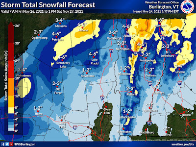
This morning's snow forecast map from the National Weather
Service in South Burlington. The main change was to 
increase snow totals in the southern Green Mountains. 
Areas in yellow and orange are forecast to see at 
least six inches of snow.
 If  you're one of those crazy people who actually like to go out for Black Friday shopping, be one of those even crazier early birds. 

At least if you're in or near Vermont.

The weather will be worsening as the day wears on with more and more snow filling in. That means increasingly slick roads with nobody yet used to driving in the snow.

If anything, the forecasted amount of snow has increased, at least in some areas. The bulk of it will come tonight.  So I guess the best thing to do this evening is stay in and watch those really icky Hallmark Christmas movies. 

The winter storm warning now extends down the entire spine of the Green Mountains from Canada to Massachusetts. 

Part of the reason for that is the swoosh of wet air that will wrap around a developing storm near Maine tonight will go further south than anticipated. That will help produce a pretty good dump in the southern Green Mountains.  

The northern summits are still probably going to get at least a foot. I wouldn't be that surprised if the summits of Mount Mansfield and/or Jay Peak come in with 20 inch storm totals. 

The western slopes of the Green Mountains are also under the winter storm warning for a pretty solid 6 to 10 inches.

Except for Grand Isle County, the rest of Vermont that is not under a winter storm warning is under a slightly less dire winter weather advisory. Most places in the state, except right along Lake Champlain and in the southern Connecticut River Valley, should see at least two inches of snow. 

As of 7 a.m this morning, precipitation was beginning to blossom across the area.  A lot of it was rain, with snow in the higher elevations. There might even be a touch of freezing rain early today in some of the protected valleys east of the Green Mountains.

Snow levels will keep coming down in elevation during the day. By sometime at or after sunset, even the low elevation Banana Belt towns in the Champlain Valley should be seeing snow. 

The snow will really come down hard along the western slopes tonight. Plus, winds will gust to at least 35 mph in many areas, causing a lot of blowing and drifting and problems with visibility on the roads. 

It won't be as bad elsewhere, but it will be no picnic.  Snow and blowing snow will be a problem even in many valley locations. It just won't be as extensive as up high. Almost everyone will see icy, slippery roads tonight.  Sigh. 

It'll get cold enough tonight so that the snow will become more powdery and less wet and sticky. That's a piece of good news because that way, we won't have to worry so much about trees and power lines falling under wet snow and strong winds. There might be a few power outages here and there, but I don't think it will be too widespread.

Expect some pretty big variations in conditions. If you're right along the shore of Lake Champlain tonight, you'll probably wonder what all the fuss is about. Drive east a few miles inland from the lake, and you'll hit hardcore winter. 

This storm is, of course, a boon to Vermont ski areas.  Some of them had to open later than planned this month, because it wasn't really cold enough to make snow. 

This big thump of snow is certainly helpful, but it's largely PR for the ski areas. Everybody's going to hear that it's dumping in the mountains, so that'll attract business.

Even better for the ski areas, though, is they're in for an extended period of subfreezing weather, probably lasting to at least Thursday. That brings plenty of opportunity to make snow and build up the bases.

The snow should taper off fairly quickly Saturday, leaving you time to shovel it all off the driveway and sidewalks. 

Little weather systems will continue to keep coming through during the first half of the new week, keeping us cloudy and cold with little bits of snow coming down now and then. It won't amount to too much

One or two of these disturbances seem like the might generate some bigger storms off the New England coast, but it looks like they'll develop too far to our east to give us any more big weather troubles.

Thursday, November 25, 2021

First Winter Storm Watch Of Season In Parts Of Vermont

The National Weather Service snow prediction map is little
changed since yesterday. Areas in yellow or orange can
expect more than six inches of snow by Saturday. 
 With overall forecasts unchanged since late yesterday afternoon, the National Weather Service in South Burlington has pulled the trigger and issued winter storm watches in parts of northern Vermont and New York. 

The winter storm watch goes from during the day Friday into Saturday. It covers northern Vermont north of Route 2, except in the Champlain Valley where the watch includes all of Franklin County but excludes Grand Isle and Chittenden counties. 

The watch also extends down the western slopes of the Green Mountains down to the slopes southeast of Middlebury.

At this point, everybody in the watch area can expect four to ten inches of snow by Saturday afternoon. 

The breakdown:

Although today, Thanksgiving, is, or at least was, expected to be dry, clouds and a few sprinkles have run out ahead of the main show that's coming in from the west.  That means you might have to deal with those very light showers today, but they won't amount to anything. You should be fine if you need some outdoor exercise to work off today's huge meal.

The real fun starts late tonight when a cold front marches in from the west. Light rain and wet snow will break out, with the snow mostly in the higher elevations. 

As the cold front passes and a storm forms along it as it heads toward Maine, winds will decidedly turn and become from the northwest. By late afternoon, most of us will see snow falling.

The storm will blossom and head north toward the eastern tip of Maine and on into Canada.

That sets up the big upslope snows we've been talking about for the past couple of days. 

The worst of it will come through Friday night and probably into Saturday morning. On the summits and western slopes, it will snow hard at times. Combine that with northwest winds gusting as high as 35 mph and you have some real travel trouble in the mountains. 

You definitely want to be extra careful driving in this one.  First of all, we're not used to driving in snow. It's been awhile. 

Ground temperatures are still fairly warm, and for many of us, this will start as rain.  As temperatures fall and snow whips up, the water that had been on the roads will freeze, forming a nasty layer of ice pavement in many areas. Then snow will pile up on top of that. 

I'd postpone driving through mountain passes until at least Saturday.  These are the usual trouble spot, like Interstate 89 east of Montpelier, Route 17, Route 125, Route 15, Route 105, those kinds of places,, among others.

Early guestimates on snow totals remain similar to those issued last night. Right along the immediate shore of Lake Champlain, there probably will be an inch or less, except maybe more way up by the Canadian border. 

But just go inland less than a mile, and you'll see two or three inches along Route 7 from about Rutland north, with four or five inches by the time you get up to Georgia or St. Albans.

The western slopes and parts of the Northeast Kingdom still seem to be in for a good six to 10 inches. More than a foot of snow still seems like a good bet on the summits of mountains like Mount Ellen, Camels Hump, Mount Mansfield and Jay Peak. 

The northwestern Adirondacks also look like they'll get a decent six to 10 inches.  By the way, northern New Hampshire and northern Maine have also been put under winter storm watches. 

The snow will stick around for quite awhile after this. Colder than normal temperatures will continue for most of next week, meaning it will be below freezing all day most days, or barely above freezing in warmer valleys.

We also have to watch another system that could come close enough to give some more snow to us around Monday. 

Wednesday, November 24, 2021

Update: First Friday/Saturday Snow Accumulation Forecasts

The National Weather Service in South Burlington this 
afternoon took their first crack at expected snowfall Friday
through Saturday. Yellow areas can expect at least six
inches. High elevation spots in darker orange could
get a foot or more. 
It's beginning to look like the spine of Vermont's  Green Mountains, and to some extent the western slopes of the Greens, the Northeast Kingdom and perhaps the northern Champlain Valley are in for a pretty good snowfall, especially Friday night and Saturday.  

The ingredients are still coming together for an upslope snow event. That's when winds are forced to glide up the western slopes of the Green Mountains, combined with lots of moisture wrapping around a storm to our northeast, will unleash a lot of snow. 

The thinking from the National Weather Service in South Burlington is that the spine of the Green Mountains from about the Sugarbush resort in Warren on north through Mount Mansfield and Jay Peak are in for a good 12 to 18 inch dump.

The western slopes - towns like Lincoln, Huntington, Underhill, Jeffersonville, Bakersfield and Montgomery might get a good six to 10 inches of snow. 

The Northeast Kingdom and perhaps the northern Champlain Valley away from the immediate shore of Lake Champlain could easily get four or five inches of snow out of this as well. 

If you're around the Burlington area, at this point it looks like you're going to see quite a gradient of snow accumulation. At Burlington's Waterfront Park, they'll probably barely manage a dusting to an inch. By the time you get out to Williston, we're talking about a possible four or five inches, if things work out as they now appear.

Note that forecasts can change. This is just an early read on the situation. 

Anyone who does get a lot of snow will see it stick around for quite awhile. It will stay too cold for any substantial melting at least through next Wednesday. 


October Was Globally Another Really Warm Month

The world was very toasty again in October, 2021. 
Note the coolness in the eastern Pacific Ocean. That 
is a sign of La Nina, which should have helped
cool the world just a bit. Not this year. 
 New data was released Tuesday indicating October for the world as a whole was the fourth warmest on record.  

The month across the globe came out to average 57.2 degrees, or 1.6 degrees hotter than the 20th century average, says the National Centers For Environmental Information or NCEI. 

That departure from normal might not seem like much, but if you average the whole world's temperature and come up with something that far above normal, that's pretty impressive. 

Octobers are now two degrees warmer than they were way back in the 1880s. Says the NCEI:

"The last eight Octobers (2014-2021) all rank among the eight warmest Octobers on record. October, 2021 also marked the 45th consecutive October and 442 consecutive month with temperatures at least nominally, above the 20th century average."

Basically, if you're about 37 years old or younger, you've never seen a month for the world as a whole that was cooler than average. 

The eastern half of North America, northern Russia a good chunk of South America and southwestern China were especially toasty, relative to average in October. For the record, NCEI ranks Vermont as having its third warmest October on record. 

With a warm year almost in the books, 2021 is pretty much a shoo-in for one of the top ten warmest years on record. NCEI gives it a more than 99 percent chance of happening.

By the way, this warm year is happening despite a La Nina pattern in the Pacific Ocean. A La Nina pattern creates cool water in the eastern Pacific.  This, in turn tends to turn the whole world just a bit cooler, so this year's global balminess overcame that. 

I'm starting to become afraid as to what will happen when we eventually flip over to the opposite pattern, an El Nino, which tends to boost global temperatures.


Mountains To Stay Snowy As Winter Settles In For Awhile

It's certainly not bright and colorful autumn anymore in 
St. Albans, Vermont. I'd say winter has descended.
 I would say at this point, we're definitely into winter now. 

Yesterday, the temperature stayed at or below freezing all day in most of Vermont, including at my place up in St. Albans. Snow flurries dusted the ground. 

 "Look around, leaves are brown, there's a patch of snow on the ground," goes that song.  Yesterday fit the mood perfectly.  

Although it will turn a wee bit milder on Thanksgiving Day, there's not any really balmy autumn weather on the horizon. The calendar says November, but this being Vermont, it's not fall anymore.

The Green and White Mountains, and the Adirondacks, are due for a decent enough dump of snow over the weekend. Valleys should get dusted, too.  Strong northwest winds on Saturday combined with the cold air will introduce some pretty nippy wind chills.

Temperatures probably won't rise out of the 30s at all most of next week. There will be other dustings of snow during that time.

I'm still a bit impressed by how much snow could end up falling on some of the favored mountains in the northern Green Mountains during the episode of upslope weather later Friday night and Saturday. 

The National Weather Service in South Burlington says there's potential for a foot of snow on some summits, like atop Mount Mansfield and Jay Peak. We'll probably see some of the first winter weather advisories of the season issued for areas like the western slopes of the Green Mountains and the Northeast Kingdom.

All this isn't to say we won't have any mild-ish spells as we head through December and beyond. Every winter has its thaws.  

But if you aren't ready for winter, and many of us aren't, too bad. Deal with it. 

Tuesday, November 23, 2021

The Vermont State Plow Truck Rumbling By Your House This Winter Now Probably Has Cool Name

This Vermont State snowplow probably has a cool name
now, thanks to 163 elementary schools naming the state's
fleet of winter road clearing vehicles. 
I live along a Vermont state highway, Route 36 in St. Albans.

Early on winter mornings, it's actually a bit comforting to hear the state snow plows rumble past the house.  They're making things passable, and safer.  

Very soon, these trucks will be plowing, sanding and salting, like they reliably do every winter.  The only difference this year is, many of these trucks will have cool names. 

As VT Digger and several other news outlets reported, the Vermont Agency of Transportation asked elementary school students statewide to name snow plows that ply the roads closest to their towns. The kids came through big time. 

Some names the elementary school students came up with for these big orange trucks with the flashing lights are awesome. Captain Snow-Merica. Snowbigone Kenobi. Snowday Buster. Darth Blader.  Edgar Allen Snow. Green Mountain Plower. Yo Bro, No Snow. William Scrape-speare. 

And inevitably. Plowy McPlowface. 

Bakersfield Elementary named their plow Jennifer Snowpez.  That town is  close to me. I hope that's the plow that rumbles up and down Route 36 by my place east of St. Albans this winter. 

My favorite of all the Vermont snow plow names came from Christ the King School in Burlington.  They named a Vermont snow plow "Carl". Just Carl. It's perfect! 

The idea to name snow plows came from Scotland, which first had public contests to name snow plows. The trend spread to North America, and soon, plows in Michigan, Minnesota, Colorado, South Dakota and Canada had plow names. 

It was inevitable, and highly welcome, that the snow plow naming trend finally hit quirky Vermont. 

Maybe we should start naming State Police cruisers next, 

Vermont Ski Areas MIGHT Get A Nice Weekend Boost

There's potential, anyway, for the Green Mountains, especially
in northern Vermont to pick up some decent snows this weekend
There might also be a little in the valleys, stay tuned! 
As previously advertised, the weather in Vermont - and most of the rest of the nation - is staying quiet in the run up to Thanksgiving Day. 

There are signs showing up, though, that there might be some interesting weather in the Green Mountain State Friday and into the weekend. 

Don't get too excited. There's nothing that wild coming.  But it the forecast holds, some of the ski areas and the mountains in general could be in for a decent dump of snow. 

Again, if things play out as things appear now, this could be a classic upslope snow event. That's when cold, damp northwest winds are forced to rise up and over the Green Mountains.  When this kind of thing persists, the snow can really pile up along the spine of the Green Mountains, and in some high elevations of the Northeast Kingdom.

It's too early for specific snow forecasts, but many mountain areas have the potential to pick up more than six inches of snow.  Since Vermont's ski resorts typically really start to ramp up for the season on Thanksgiving weekend, this is good news.

Of course, resorts that cater to downhill skiing and snowboarding rely more on making snow, especially in the early season, and I know the snow guns are cranking in today's subfreezing air. If this snow does materialize, it will just be icing on the cake. 

These upslope patterns usually bring little or no snow to the Champlain Valley, the deeper valleys of southwest Vermont and the lower Connecticut Valley, and that will probably be the case here.

The initial cold front seems like it will give us a rain changing to snow scenario in many valleys, including the Champlain Valley. It's a little soon to say when the changeover might happen and how much snow will result. 

We'll have to watch the potential for some light accumulation and slippery driving conditions.  Even in the valleys. The National Weather Service in South Burlington is wisely not getting specific with expected accumulations yet. Way too soon to get into that. 

Snowy roads will be almost a certainty in high elevations Friday night and Saturday. We'll update with specifics when we get closer.  We still have a lot of room for forecasts to change between now and Friday. 

In any event, Saturday looks cold and windy and cloudy and raw.  The northern Green Mountains have the potential - just the potential at this point - to be a winter wonderland by then. 


Monday, November 22, 2021

Climate Assessment For Vermont: Less Snow, More Floods

A climate assessment for the Green Mountain State
shows us more big changes are coming to Vermont
in the coming decades. 
 Vermont is hotter, wetter and has more variable weather than a century ago, thanks to climate change, according to a new climate assessment from the University of Vermont.

The findings are not surprising (at least to me) and match climate data from other sources, but the assessment does serve as a great blueprint on how we will need to navigate further effects from climate change. 

Ski areas will need to adapt to shorter snow seasons. More intense storms means we'll have to continue fortifying ourselves for more intense floods.

Agriculture will also have to deal with that increased risk of excessive rain, with wild jolts into drought occasionally to make things even more complicated. Forests and wildlife will change. 

The report was produced by the University of Vermont's Gund Institute for Environment and released earlier this month.  The whole report is a follow-up to a similar 2014 Gund Institute study. As Seven Days reports, that 2014 assessment was the first in the United States to examine climate change at a state level.  

Two of the key takeaways from the report are that winters are warming faster than the other seasons and snow season is growing shorter. Also, precipitation events are getting heavier, leaving Vermont more prone to flooding. 

Those floods sweep crud, nutrients and silt into rivers, ponds and lakes, which wrecks water quality and increases the chances of algae blooms, some of which can be dangerous and poisonous.

The report tells us that Vermont's average annual temperature has increased by almost 2 degrees since 1900.  Winter temperatures are up 2.5 times faster than the overall annual temperatures over the past 60 years.  The number of very cold nights has decreased by over seven days in the same time period.

Vermont, as we know, is really forested. It will probably remain that way, but your grandchildren will probably see a very different forest when they're old than you do now.  The familiar sugar maples, balsam fir, yellow birch and black oak will be less prevalent than they are now by 2100. In their stead will be more northern red oak, shagbark hickory and black cherry. 

It will be a gradual process, as the older species slowly die out and young new species take over. 

It's also possible climate change will make iconic Vermont species like the common loon and hermit thrush disappear from the state in the coming decades, according to the report.

One finding that stuck out for me is this, from the report's executive summary. Average annual precipitation is up 21 percent since 1900 in general, but is becoming more variable. BUT, as the executive summary states: 

"Vermont is also becoming wetter......However, Vermont still experiences prolonged droughts because of shifts in the water cycle, and different regions of Vermont can experience different climate impacts."

There was a classic example of this during the past summer. Southern Vermont was sopping wet, and experienced damaging floods. At the same time, far northern Vermont was gripped by drought.

 An interesting note in the climate report is something I've brought up previously. The effects of climate change in Vermont will be big and noticeable and impactful, but perhaps not as dire as in other parts of the nation, or the world. 

Will that mean Vermont will become a haven of sorts from climate change?

As Seven Days reports, the latest Vermont climate assessment doesn't see any evidence yet that people are flocking to the Green Mountain State to avoid the worst of climate change.  Honestly, things have not gotten that dire yet for most Americans. 

The pandemic has been a cautionary tale, however, as people stampeded into Vermont from cities as the crisis took hold, hoping to avoid the crowds and contagion of cities. For better or worse, I guess.  

I've lived in Vermont all of my life (so far!). I've always been attuned to what nature is doing out there in any given moment.  I can tell you things are much different from when I was a kid.  I won't list them all, but I've noticed winters are far more variable, summers are hotter, spring is earlier and most autumns are later than they used to be.

As the latest Vermont climate assessment shows, we can expect perhaps even bigger changes in the coming decades as the world continues to warm. 


Sunday, November 21, 2021

There's Still False Storm Hype Out There, Despite Tranquil Forecast

This image on the National Weather Service home page was
not at all colorful this morning. That's a good thing. Lots
of color on this map means lots of warnings and 
weather dangers. Seems mostly clear for 
Thanksgiving travel today! 
 Gawd, I  hate clickbait. 

That's when you put out some sensational or shocking news out there on social media to garner clicks, eyeballs and presumably income, even though the actual news is much less exciting. 

With weather forecasts, it's fine to say some long range computer models suggest something noteworthy, like a big storm, IF you qualify it somehow in the headlines and prominently in the story that the storm is not set in stone. 

As of a week ago, some computer models a week ago were suggesting the possibility of a very disruptive storm in the United States Thanksgiving week.

As better data came in, it became clear by Friday that the early computer models were a bit overwrought. No major storm would form. Just the typical November ick in spot. 

Still, as of Friday and even Saturday, major players like AccuWeather hyped the potential storm in their headlines, which I think pushed it too far.  At least AccuWeather backed down somewhat with the headlines when it became clear Thanksgiving travel would not get screwed up by any kind of big storm. 

Still, as of this morning, AccuWeather still had a link to their story on Twitter, posted just yesterday, headlined, "Brewing storm to threaten disruptions at worst possible time."

To be clear, there might be periods this week where some corners of the nation might have kind of "meh" weather that's not great, there is no storm to speak of that's brewing.  

As of this morning, the Weather Channel still had a headline up headlined "A Couple Of Rough Travel Days Ahead."

With the volume of travelers, and staff shortages, combined with not-at-all-extreme rain showers and gusty winds in the Northeast Monday, flight delays and a few cancelations are inevitable, but this isn't Armageddon, and weather will only be a bit player in any chaos. 

NBC News was still tweeting on Friday the headline, "Thanksgiving week storm gearing up to affect busiest airports in the nation."   Sorry, no it wasn't. 

There are YouTube videos up posted just yesterday, some correctly saying no big storms are on the horizon, others still hyping.

 To pat myself on the back a little bit, my headline for potential Thanksgiving week storminess that I posted last week said. "Still Question Marks For Next Week."

My Friday morning headline was, "We Can Forget About That Thanksgiving Storm, (I Think!)"

The "I think" was to cover my ass in case there was an unlikely surprise shift in the forecast. So far the only shift I see is turning an already mediocre expected cold front even more lame. 

I'm not a meteorologist, even though I've had training in the field. I'm just a weather enthusiast who relies on outfits like the National Weather Service to get my information. Sometimes I get things wrong.  Happens to everyone. I apologize, correct or explain myself and move on. We're all humans. Nobody gets it right all the time. 

I also happen to like, even love clicks in my direction on social media.  But it's irresponsible for anyone to exaggerate things to cause false alarms, all in the effort to gain attention.

I know that's the way of the world these days. Social media clicks are the new personal validation and also money making enterprise. But this old fart still rebels against all that. 

So sue me already.


Saturday, November 20, 2021

Thanksgiving Travel: Lucky Break Coast To Coast

 Quick update

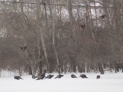
Wild turkeys gather in my St. Albans, Vermont yard several
winters ago.  Maybe thought it was a refuge from becoming
holiday meals?  Speaking of refuge, it looks like holiday 
travel across the nation will be much better than originally
anticipated. 
After some fairly dire computer models that suggested lots of storminess in the United States during holiday travel for Thanksgiving next week, everything is now turning up roses.  

It now appears there will be no major weather in anywhere in the Lower 48, at least. 

The only problems I could find was some non-flooding rains in the Pacific Northwest, early week chill in New England, and the usual patchy snow in the Rocky Mountains. 

That's a huge contrast to some forecasts from a week ago, which suggested a large storm in the Great Lakes and East.  

There will be a large storm, but it will be several hundred miles off the New England coast and no bother to us. 

By the time Black Friday rolls around, it does look like it will get nippy in the upper Midwest and there will probably be lake effect snows around the Great Lakes. 

"Scorpion Flood" In Egypt Should Have You Thankful For Your Bad Weather

Weather worse than ours: A flood in Egypt unleashed a 
plague of venomous scorpions, and more than 500 
people were stung. All survived, but still.
 Many of us don't like November weather here in Vermont.

It's usually dreary, damp and cold. We have a brief window daily of semi light under cloudy skies after a late sunrise and before an early sunset. 

The weather could throw anything at us this time of year.

Compared to some areas, though, we should thank our lucky stars that our biggest weather problem at the moment is November gloom.

Let's take Aswan, Egypt as one great example. Recently, they had a destructive flood, which is bad enough. What's worse, the flood carried a whole bunch of scorpions through the streets and into homes.

Aswan averages just 0.12 inches of rain a year. That's a sprinkle to us. It's super, super dry there.

So when a torrential thunderstorm drenched Aswan recently, residents were shocked. It resulted in a terrible flood, and three people lost their lives. But that was only the start of Aswan's problems. 

Let's let the Washington Post pick up the story from here:

"The rains also unleashed something especially sinister: hordes of highly venomous scorpions whose stings hospitalized 503 people, according to Ehab Hanafy, undersecretary of the Health Ministry of Aswan. 

Aswan Gov. Ahsraf Attia told the AP that those stung and hospitalized were given anti-venom does and released.  Al-Ahram, a government-run Egyptian newspaper, reported that doctors were called back from vacation to assist with the treatments."

It was initially reported that the three deaths were due to scorpion stings, but that turned out not to be true. They died in the actual flooding.  

Although everyone survived the scorpion stings in this instance, none of the victims exactly had fun with the experience.

Reports Al Jazeera: 

"People who were stung by the scorpions said their symptoms included severe pain, fever, sweating, vomiting, diarrhea, muscle tremors and head twitching."

The scorpion danger still exists in and around Aswan after the flooding. Al Jazeera says the Egyptian Ministry of Health has stockpiled 3,350 doses of anti-venom in Aswan, just in case. 

The variety of scorpion native to Egypt and other areas of the Middle East and Africa are among the deadliest in the world. They tend to hide under rocks, crevices, rocks, and even inside homes during the usual hot weather. Even the scorpions hiding in homes more often than not don't bother anybody, because they are well, hiding. 

The flooding flushed the scorpions out from their hiding places, where they stung people on streets, in cars, in homes, whichever place was affected by the flooding. 

The scorpion attack was a rare event because heavy rain is a rare event. However, when it does rain in Aswan, it can come down hard. They might go a few years without any appreciable precipitation and then - WHAM! They get a Vermont-style, torrential humid summer thunderstorm or worse.

The soil, and the infrastructure around Aswan can't handle these big storms. So there's floods. And scorpions. 

And you complained about slipping on your frosty, ice covered front steps this morning?


  most deadly” in t

Friday, November 19, 2021

We Can Forget About That Potential Nor'Easter (I think!)

It looks like instead of a big snowy nor'easter early next week
we'll get more of this. Typical November gloom. My backyard
sure is no longer lively, with mulched garlic, clymatis dying
back brown hydrangea in the background and 
dead leaves strewn everywhere. 
 There's been lots of speculation about a potential nor'easter early next week that would disrupt Thanksgiving travel in and near New England. 

The good news is that nor'easter is looking less and less likely, at least for now. The bad news is there still might be some travel disruptions. 

Disruptions even without any real blockbuster storms to talk about. More on that in a minute.  

The nor'easter speculation came because of a big developing blocking high pressure system near Greenland.  That would gum up the works in the normal, general west to east flow of weather systems.

That would allow a storm coming in from the west to plow into this blockage and help develop the nor'easter and keep it near the coast.

It still looks like that storm from the west will come and generate that nor'easter. But the blocking high pressure area near Greenland now looks like it will develop a little later and a little too far to the east to steer the storm toward New England.

Instead, chances are increasing it will develop well east of New England and meander around, well offshore. It'll be close enough to keep us in a cool northwest flow for the first half of next week, and maybe generate a few snow showers for us, especially in the mountains, but that's about it.

Forecasters will still need to watch this in case the storm does manage to form closer to the coast. It still could happen, but the chances of that seem to be diminishing. I think you're safe from that storm unless you plan to be on a boat a few hundred miles east of Cape Cod next week. 

That's not to say we won't have travel disruptions. Things are so sensitive with airlines now.  They have staff shortages, Covid restrictions, and very heavy travel demand between now and Thanksgiving. It won't take much to throw a monkey wrench into the whole system.

That monkey wrench could prove to be that initial storm coming in from the west. In the grand scheme of things, that storm isn't anything extreme for November.

It will throw some wind and snow through the Great Lakes. The Northeast, including Vermont, will have a bout of wind and rain, especially on Monday.  That all could  trigger a few flight delays, which would have a cascading effect of more canceled and delayed flights as airline staff would end in the wrong places at the wrong times as a result.

So be patient. 

At this point, it doesn't look like we'll have any big snows to screw up driving along Vermont's highways over the Thanksgiving holiday.

On the bright side these mid-sized, but frequent storms recently have been good for Vermont. The U.S. Drought Monitor took northern Vermont out of drought conditions three weeks ago.

Ground water levels haven't fully recovered in far northern Vermont east of the Champlain Valley, so that area is still considered "abnormally dry."  A continued active weather pattern should help with that.

Thursday, November 18, 2021

I Demand World Meteorological Organization Approve These New Weather Terms

People in Burlington, Vermont walk gingerly on icy 
sidewalks after a bout of Sleeze (a mix of sleet and
freezing rain) on Feb. 6, 2019. 
 We're getting into the winter weather season, which means many of us in the Northern Hemisphere are starting to deal with a variety of nasty winter precipitation types.  

As great as outfits like the National Weather Service and countless local meteorologists are, we really need to make winter weather terms, shall we say, punchy. It'll get everyone's attention .

I was inspired by this yesterday when a few half melted sleet pellets landed on me when I was trying to get my last garden stuff done before winter.

The sleet was basically slush. Not really ice, not really water. 

So, what fell on me Wednesday was Sleesh

That's a mashup between sleet and slush. It gets the point across.

This got me thinking about other types of winter precipitation and which words we should use to describe them.  

Here's a sampling of what I came up with. 

Frizzle: Freezing drizzle. Just mash up the two words to make things efficient. 

Sleeze: A mixture of sleet and freezing rain

Slain: A mixture of sleet and rain.

Sneeze: A mix of snow and freezing rain.

Sneet: Mixed snow and sleet.

Sleeze: Mixed sleet and freezing rain. 

Snain: Mixed snow and (non-frozen) rain. 

Snail: Graupel. Which is essentially a hail/snow combo all in one, so just combine snow and hail into one word. 

Some of the words I came up with are already in use for decidedly non-meteorological things.  But I'm sure the wordy dictionary loving types can come up with new words, to describe issues like what we do when we have allergies, the past tense of a murder, and a slow moving, shelled gastropod. 

We've all had to make big adjustments during this long pandemic, so what's another adjustment to the English language?  I'm sure non-weather geeks could find other words  "Slain", "Sneeze" and "Snail" and let us have those words. 

This is a demand, a plea, to the World Meteorological Organization to accept these words as official, scientific weather terms. 

To keep up the pressure, lets get the National Weather Service, Environment Canada, the UK Met Office and all the other national weather bureaus to sign on.  Plus the private weather companies, like the Weather Channel, AccuWeather, WeatherNation and others. 

The bottom line is we need to make bad weather as fun as possible. These words do the trick. 


Quick Update: Typical November Inclement Weather, Still Question Marks For Next Week

Empty garden: As November rolls on with unsettled weather,
my St. Albans perennial gardens take on that bare winter look.
 Wow, it's so much balmier this morning here in Vermont than it was yesterday!  

We certainly got hit by a warm front. Early yesterday morning temperatures were close to 20 degrees, now they're above 50.  

The temperature roller coaster is going to continue as a cold front is close on the heels of that warm front. 

It'll stay windy, especially in the Champlain Valley until the cold front gets here this afternoon with a batch of rain that will move west to east across the region. Not a biggie, with most of us in line to get between a quarter and a half inch of rain, with more in the mountains.

The warm temperatures will disappear overnight as we get back to near or below freezing by Friday morning. On Friday, we'll be enjoying the usual November weather of clouds, chilly breezes, snow flurries and snow showers. It won't amount to anything in the valleys but the mountain tops could pick up a few inches of snow. 

The mountains will win with the snow in part because lake effect snows from the Great Lakes will make it all the way to the ridge lines. The hills and mountains will protect the valleys from much of the lake moisture, so it won't exactly be a winter wonderland down in the lowlands.

Forecasters are still watching out for storminess early next week.  It's usually stormy this time of year in the United States, and that often leads to flight disruptions during the busiest travel time of the year.

This year, it could be worse. Even a modest storm could delay or cancel some flights, leading to a ripple effect as the cancelations exacerbate staff shortages.  The canceled flights will mean some airline personnel won't be where they need to be to keep flights going.  That leads to more canceled flights and on and on it goes.

Thank goodness I'm not flying anywhere next week!

So, storminess. The initial storm will move through the Great Lakes Monday, spreading snow and strong winds through that neck of the woods.  It won't by any means be the worst storm ever in the Great Lake, but it could still disrupt flights in and out of the Midwest.

The storm will go by to the west of New England, so it will rain here in Vermont next Monday.

Then, it gets tricky.  The weather pattern is about to get a bit gummed up, and there's indications a new storm will want to get going near or off the northeastern United States coast.

If it's far enough out to sea, all we'll see in Vermont is snow showers, cold weather and chilling north winds. If it's closer, we'll need to worry about accumulating snow Tuesday and/or Wednesday.

There's still no way of knowing for sure, so we'll sit tight and watch.

, asthat lake effect mois

Wednesday, November 17, 2021

The Inevitable Slide Into Winter Continues

TONS of frost on my truck early this morning in St. Albans,
Vermont. I had the luxury of waiting for the sun to melt it
off later in the morning rather than having to scrape
all that ice away.
 I couldn't believe how thick the frost was on my truck, and basically everything else outdoors this morning in St. Albans, Vermont.

It was clear and calm overnight, and temperatures fell to their lowest levels yet this season. Most of us were around 20 degrees, with teens in the Northeast Kingdom. So, I'm sure you were spending a lot of time scraping the ice off your car this morning. 

All this is not unusual for this time of year. And t could be a lot worse. Two years ago on this date, we had record low temperatures in the single numbers, with a few places below zero. 

Still, the slide toward winter continues.  I see the first mentions of sleet and freezing rain in northern New England forecasts this morning. 

Before you panic, if there is any mixed precipitation in Vermont this evening, it will mostly a problem in the Northeast Kingdom. There is a winter weather advisory now up for Essex County in extreme northeast Vermont for the risk of a little sleet and freezing rain to ice up the roads.  

There are also winter weather advisories in northern New Hampshire and northwestern Maine for mixed precipitation tonight, so watch it if you're headed that way. 

For the time being, the weather pattern is very active, and as we head toward the end of Thanksgiving, winter weather hazards will be part of our lives off and on. That's our lot until at least March, of course.

The next storm in this active pattern is coming through tomorrow. That bit of rain this evening in the north is due to a warm front coming through. Temperatures will actually rise overnight for most of us.

That is actually another sign of winter. The sun is weak now, and in the winter, and weather systems are stronger. That means warm and cold fronts can overpower the influence of sunshine or night time darkness.  Warmer air flooding in will make it get toastier as the night goes on.

What comes up, must come down. It'll be a warm Thursday morning, and quite windy, with gusts to 40 mph in the Champlain Valley.  Rain will come in with a cold front in the afternoon, and temperatures will drop again starting in the mid to late afternoon.  

By then and on Friday, we're back to our usual November regime of cloudy skies, and snow showers, with accumulations pretty much limited to higher elevations.

Things are still looking pretty stormy early next week in this active pattern.  The forecast is still evolving so a lot of it is guess work at this point. 

The initial part of the storm should go by to our west Monday, keeping us warm enough for rain. But will a second storm form along the coast and give us accumulating snow Tuesday and Wednesday? It's possible, but we still have no idea.

In any event, there is some potential that the storm could be big enough to disrupt airline flights in the Midwest and East at the beginning of the week. Since that will be the big travel week of the season, with Thanksgiving at all, it could have a ripple effect across the nation with travel if worse comes to worse.

That's winter in Vermont. It will keep you guessing.