Showing posts with label roads. Show all posts

Monday, January 26, 2026

Vermont Snow Finally Winding Down. More Than A Foot Many Places. Long Cold Spell To Continue

The view out my home office window in St. Albans,
Vermont as getting increasingly blocked by snow 
after todays snowstorm. 
As you surely noticed if you live here, it snowed lightly all day in Vermont, adding to the totals we talked about this morning. 

The snow has an incredible fluff factor, so seemingly, we had a lot more snow.  As the next few days go by, though, the snow that piled up should settle by several inches. 

Especially since, after this evening, very little if any new snow is on the way until at least next Saturday, and possibly beyond that. 

But the snow we have is sure as hell not going to melt. We have a lot more cold air coming. More on that in a minute. 

It's beginning to look like northern Vermont might have gotten a little more snow than the south, which is opposite of what was forecast. The following won't be final totals, since it was still snowing in most of Vermont. 

But so far, the biggest totals I've seen are 19 inches in Waterbury Center, 18 inches in Walden, 16 inches in Morrisville and 15 inches in Danville. 

As of 1 p.m in Burlington, they had collected 13.5 inches. And it kept snowing after that. Here where I am in St. Albans, I'm lagging behind a lot of places. As of 4:30 p.m, the storm total measurement was up to 10.2 inches. 

Even if you didn't like dealing with all the snow and the frigid temperatures, we in Vermont should thank our lucky stars. Of all the states affected by the huge winter storm that thrashed the U.S., Vermont was one of the few places where the storm probably did more good than harm. 

It's giving a great boost to the winter sports industry and tourism. And it's just a bit more water than will melt into the ground come spring. It'll help the growing season get off to a good start. 

LOOKING AHEAD

This snow isn't going to last much longer, if it hasn't already quit by the time you read this. Most of us should be done with it by 8 p.m. or so. If not sooner. 

Of course, if you're driving home from work or wherever this evening, the roads are still covered in snow statewide Obviously, take it slow. 

Since it's staying cold, the roads won't be pristine tomorrow morning, either. You'll need a little extra time to get to work because we'll still have snow on the roads. 

COLD WEATHER

We are by no means in the most intense cold wave on record here in Vermont, but it looks like it will turn out to be one of the longest lasting ones in quite a long time. 

The temperature fell below 20 degrees this past Friday in Burlington. If current forecasts holds, it won't make it to 20 again until maybe a week from now. I don't have time this afternoon, but by tomorrow morning I'll look up when the last time that happened. 

Overnight lows will stay near zero each night. Below zero in a lot of places. The cold should tend to intensify a bit Thursday, Friday and Saturday, when temperatures could go well below zero at night. 

At least it doesn't look as bad as Friday and Saturday, when some places got into the 20s below. 

By the way, I had wondered if anybody in Vermont made it to 30 below Saturday night. As far as I can tell, the answer is no, But East Haven got down to 29 below, so close. 

As I mentioned this morning, I'm hearing some buzz about a possible nor'easter toward next Sunday. and/or Monday Some of the computer models do suggest such a storm. So far at least, it seems the forecasts are trending too far east to give us much more than a worsening wind chill from north winds.

That prediction can become wildly different one way or another by the end of the week, so as always, we'll update as needed  

Another Round Of Snow Moving Into Vermont After Overnight Dump

Snow covered roads around Interstate 89 Exit 14 in 
Burlington in this web cam grab from around 8:15 this
morning. Roads and highways should keep looking
like this all day as at least light snow should keep
falling amid continued cold temperatures. 
 As expected, our fluffy, cold snowstorm from yesterday and last petered out before dawn today, but more snow was moving in, especially in central and northern Vermont. 

The most snow I've seen in Vermont so far is 14.5 inches in Woodbury. Generally, most places so far are in the 6 to 12 inch range so far.

At this point I'm guessing snow totals will come in a somewhat less than the 12 to 24 inches that had been expected south, and pretty close to or just a little below the 10 to 16 inch storm total that we thought we'd get in the north.  

The National Weather Service in South Burlington said part of the problem was it was almost too cold for a decent snowfall.  Especially in the early part of the storm, while temperatures were near 0 or just above that level, the snow came as tiny crystals instead of nice, big snowflakes. 

You probably noticed how itty bitty the flakes were in many areas yesterday afternoon and evening.  That kind of snow does't accumulate fast. In northern Vermont, the clouds also weren't quite as packed with moisture as they could have been. So they yielded a bit less snow. 

Also, the period when snow tapered off and the time it is beginning again widened some, which is also cutting down the totals a bit. Those three factors cut down a snow totals a little 

It looks like Vermont was just north of the really heavy stuff. I see widespread 18 inch totals in central and eastern Massachusetts, in northern Connecticut and New York's Catskill region. 

Still, all of Vermont ended up with a decent snowstorm, so we can't complain too much about that. 

I noticed when I went out this morning the snow - again as expected - is light and feathery. I'm so glad it's not the wet cement we've had so often in recent winters. But it's still cold out. Temperatures were still only in the single numbers this morning and will only rise to the teens this afternoon.

The cold takes more out of you when you're shoveling, especially if you're older. So you want to take care while clearing the snow. Or borrow an athletic teenager to do the work. School is canceled due to the weather in many if not most places today in and around Vermont. So it might be easy to find some labor. 

As you might have guessed, pretty much all the roads in Vermont are snow covered, so they are slippery. Sure, it stopped snowing for awhile in many places. But it's way too cold for salt to work, and we have a road salt shortage to deal with. 

So whoever is driving Clearopathra and all the other wonderfully named Vermont snowplows isn't exactly spraying road salt all over the place. 

REST OT TODAY

Forecast for additional snow today. Another two to six inches
with two most in northwest Vermont and along the 
spine of the Green Mountains. 
As of 8 a.m., it was starting to snow again here in St. Albans. The snowflakes are bigger than those tiny crystals and needles from yesterday, so it will accumulate nicely. Especially since the snow will continue to be light and fluffy. 

Radar imagery at around 8 a.m. showed snow both pressing in from New York, and blossoming on its own in the Champlain Valley. 

So I think the early morning break in the snow is pretty much over. The snow will spread into the rest of Vermont during the morning. It'll probably be lighter south of Route 4. 

The snow should shut off pretty quickly this evening once the last piece of this complex storm says bye-bye and heads on off to the east. 

Another two to four inches is likely in southern Vermont today with there to five inches north. The five inch amounts will mostly be in the northern Champlain Valley and central and northern Green Mountains.  

REST OF THE WEEK

It'll be a cold one all the way through the week. 

Daily daytime highs today through Saturday at least will be in the teens. Lows will be near or below zero. Fresh snowfall tends to make the bottom drop out of the thermometers at night. If we get a clear night, a lot of us will get into the teens below zero. Some places might get into the 20s below if one of those clear nights happen.

We will have little if any new snow during the week. A few lame disturbances might throw a few snowflakes at us, but that's about it. Maybe the northern Green Mountains will catch a couple additional inches of snow after today. 

But at least we have enough powder now to play in, right?

Almost all signs point toward continued cold weather into mid-February and quite possibly beyond that. 

The next shot at a storm would be next Monday as some computer models are hinting at a nor'easter. But most of the models that do develop such a storm keep it too far east of Vermont to give us much of anything. But we've been surprised before. Sometimes the models change their minds and bring the storm a little closer to the coast. As always we'll keep an eye on it. 

EDITOR'S NOTE: We haven't done an update yet today on the much worse weather elsewhere in the U.S. this morning. That will come in a post later today. 

Monday, December 29, 2025

Vermont Monday Morning Storm Update: Could Have Been Worse, But Still Icy/Messy. More Drama Ahead

An example of the challenge the freezing rain brought
this morning This traffic cam grab shows the pavement
on Route 125 in Ripton looking absolutely scary icy,
with trees weighed down by the ice, too. 
By 7:30 this morning, I heard the welcome thump of snow sliding off my roof here in St. Albans, Vermont. 

The told me the temperature was above freezing here, and the threat of more icing had passed. 

We're lucky the worst of this hit overnight. All roads were virtually impassable across the state at the peak of the icing late last night and in the predawn hours. 

Because the roads were so bad, all state offices were closed today. People who could work remotely were still on the job, but state officials warned that electricity and internet connectivity might be iffy. 

Overall, temperatures around dawn today were a little warmer than forecast, which is great news. Freezing rain overnight and this morning is still extensive, but not as disastrous as some forecasts last evening indicated. 

It turns out not many of us will have an half inch of ice or more breaking trees and power lines. A few places will have that, but not many. And there's plenty of trouble spots this morning. 

Let's got west to east across Vermont for a morning assessment:

Champlain Valley/Souithwest Vermont

As of 7:30 p.m. temperatures in the far southwest near Bennington were in the upper 30s, with mid 30s in the Champlain Valley. Main roads in those spots were just wet for your morning commute. But untreated surfaces like dirt roads, driveways and sidewalks were still awful. 

Try to avoid those dirt roads for awhile yet. And for gawd's sake watch your step. Here at my place in St Albans, the tree have no ice on them, but my driveway is scary as hell. 

Some places in western Vermont that are protected from the winds were still seeing freezing rain. Rutland and Middlebury were still at 32 degrees as of 7 a.m. 

Traffic cameras along Route 4 in West Rutland and Fair Haven still showed slick pavement and iced up trees as of a little bit before 8 a.m. I notice a smattering of power outages in central Rutland County. 

Central/Eastern Vermont

Traffic cam grab on Route 4 in Quechee a little
before 8 a.m. this morning looked pretty slick
Note that pine tree in the background was
sagging under the ice pretty badly. 
As expected, it's worse out there once you get to the Green Mountains and points east. A few places, like Montpelier and St. Johnsbury, were a bit above freezing before 8 a.m., many other places in this one were still at or a little below 32 degrees. 

Roads conditions on traffic cameras in these areas looked varied. Most of Interstate 91 seemed wet, with some icy areas. Some secondary roads had a mix of bare pavement and ice, and other roads looked like skating rinks

The bulk of the power outages as of 8 a.m. were close to Montpelier and in the Connecticut River Valley between Rockingham and St. Johnsbury. Nearly 3,700 homes and businesses were without power as of around 7 a.m., but that declined slightly to 3,200 or so by 7:45 a.m.  That might be a hint that the worst is behind us, fingers crossed!

REST OF TODAY

It was still raining pretty hard and steadily around Vermont as of 8 a.m. That will continue more or less for a few more hours. It looks like this morning's rain will be steadier and heavier in the southern half of the state, compared to the north. 

The rain statewide will tend to get a little more showery as we head toward late morning, and the bulk of the rain should be done by 4 p.m or so, if not earlier.   

The storm's cold front will blow through early this afternoon, changing any remaining rain to snow towards dusk.

But by then, we will have lost the deeper moisture, so we won't have much accumulation.  But by the evening commute, any water left over on the roads your driveway, your walkway will freeze, so it will continue to be dangerous underfoot.

Dustings of snow atop the ice will make it even more slick. The northern and central Green Mountains might pick up two or three inches of snow by tomorrow morning, so nothing spectacular.

Since it will be cold for the foreseeable future, you will need to be careful for the next several days, or even weeks, as the ice on untreated surfaces will remain. 

This will be a sharp return to frigid weather. Temperatures will be within a few degrees either side of 10 degrees by dawn Tuesday. Gusty winds will make it feel much colder. 

It looks like for at least the next week starting tomorrow, it will stay colder and drier than normal with only light snows. I'll get more into that in future posts, once we get past today's storm.  

Tuesday, December 23, 2025

Quick Tuesday Evening Vermont Snow Update: Road Conditions Going Downhill

Traffic cam grab shows slushy roads in Burlington
late Tuesday afternoon as the snow continued to fall
Here's our quick Tuesday evening snowfall update for Vermont:


The snow arrived about an hour or so later than forecast in much of Vermont this afternoon, but it did arrive.

As of 5 p.m., it was snowing lightly statewide. This evening, we're in the peak of the storm, though this isn't exactly a scary one. 

Still, the roads for the evening commute, or going shopping, or to holiday events won't be great. Temperatures in some areas were at or just above freezing in some warmer valleys for part of the afternoon. But those temperatures have fallen a degree or two as darkness arrived. 

The snowfall rates also picked up a little at sunset, too. Highways that had been just mostly wet at around 4 p.m. were getting snow and slush covered, and more slippery by the minute. 

The steadiest snow in the valleys should last until around midnight, give or take, depending on where you are. Forecast total accumulations haven' changed, with two to five inches expected across most of Vermont. The mountains are still likely to do better than that, with roughly four to eight inches up there. 

Christmas Eve continues to look as if it will bring us quiet and rather cloudy weather. Forecasts for Christmas Day have changed a little, with a bit more snow than originally forecast. But it won't be much, with maybe an inch or two north and less than an inch south. 

Wednesday, December 10, 2025

Vermont Snow Tapering Off In Lowlands, Keeps Cranking In The Mountains

The snowy view through the windshield on 
Dorset Street in South Burlington this afternoon. 
Our daylong snowfall in Vermont has left us with a good two or four inches, locally more of snow. As of 4 p.m. here in St. Albans, we had 3.4 inches of new snow. 

Roads statewide have been tricky all day with the steady snow. I notice on Interstate 89 by mid-afternoon, visibility occasionally got really poor in areas near pine trees. The wind was picking up and blowing around the snow that collected on those branches

As usual, there were a number of crashes and slide offs, though I noticed people on Interstate 89 between St. Albans and Burlington were behaving pretty well. Though I learned later, as of around 3:50 p.m. traffic was backed up on the Interstate  northbound near Milton due to a three-car  crash. 

I also see that a school bus slid into a ditch and landed on its side on Route 12 in Middlesex

 A well anticipated "dry slot" - a tongue of dry air drawn into the storm -  was moving into western Vermont as of 3:30.  It'll keep spreading eastward into Vermont to at least mostly and temporarily shut off the snow. Views from Burlington at 4 p.m. showed a small ribbon of sunshine trying to peak through the clouds as it set. 

The wind is stronger in that dry slot, so blowing snow will continue to be a problem this evening.  With the snow getting lighter, but might not entirely stop. Road conditions might improve a little this evening, but won't be perfect. Expect slushy and snow covered roads, and maybe some visibility problems from blowing snow from time to time. 

The dry slot also contains a little bit of warmer air, so temperatures in the Champlain Valley could sneak up to near or a bit above freezing for several hours this evening. That will help improve road conditions somewhat.

The bottom line is your drive home this afternoon and evening won't be great. Many roads are snow packed, or at best, slushy.  To take it easy out there. 

A noticeable cold front barging in toward midnight will quickly drop temperatures into the 20s. Depending on where you are, the drive into work tomorrow morning won't be that great. The Champlain Valley, the Route 7 valley floor in southwest Vermont and the  lower Connecticut Valley should have nothing more than a few icy patches and some nuisances snow showers.

There might also be some trouble once again with blowing and drifting snow in open areas. 

However, the Green Mountains should stay in the snow pretty much all day as wet northwest winds will continually be forced to ride up and over those mountains. The rising air over the mountains means plenty of snow. 

Some summits might see six or more inches of snow. The Jay Peak cloud in the far north seems like it wants to work overtime and has the potential to dump a foot of snow up there.  


Wednesday Morning Vermont Winter Weather Update: Snow Delay Helps Morning Commute, Still A Ski Area Storm

This morning's updated National Weather Service 
snow forecast map. Biggest winners are 
the Green Mountains, as usual. Southern Green
Mountains look especially lucky in the 
snow department. Champlain Valley to
escape with just a couple inches. 
As we wake up here in Vermont this Wednesday morning, there are, as always, some changes to the forecast for the latest storm. 

First, we'll quickly clean up some updates on the frigid morning yesterday. 

It turns out the coldest spot in the Lower 48 of the United States yesterday was right here in Vermont. East Haven in the Northeast Kingdom took the honors with a low of 27 below. 

In Burlington, the low of minus 7 in   was the chilliest December temperature since 2017. Burlington has had three days this month already that have been below zero. There have only been seven years since 1884 with that many subzero days by December 9. The last time it happened was in 1989. 

TODAY'S SNOW

Here are the changes to the forecast based on new information since last evening:

Later Onset.

 The biggest and best change is the beginning of the snow is delayed. Much of this morning's commute in most of the state will be OK and better than expected. 

Some light snow was starting here a there as of 7 a.m. today, so there might be some minor issues on the roads. But the heaviest snow should come through between 10 a.m. and 4 p.m., says the National Weather Service office in South Burlington. 

Advisory Expanded

The winter weather advisory that covered most of Vermont outside the Champlain and lower Connecticut Valley has been extended to cover far northern Vermont near the Canadian border.  That's not at all a surprise, as that area has been forecast to get quite a bit of snow with this storm for awhile now. 

People who are under the winter weather advisory can expect three to seven inches of snow by 1 a.m. Thursday. 

Valleys "Cheated"

This isn't so much a change in the forecast but rather new information to reinforce the forecast ideas the National Weather Service had yesterday.

Most of the Champlain Valley and lower Connecticut Valley are only going to get a couple inches of snow out of this.  Westerly winds aloft will make winds blow down the eastern slopes of the Adirondacks and Green Mountains today. Air blowing downhill tends to dry the air out, so that creates  less snow.

Also, warmer air moving in this afternoon will make temperatures pop up to a little above freezing in those valleys. That will tend to settle the snow and maybe make whatever snow is falling mix with a raindrop or two. Finally, a push of dry air entrained into this storm will help shut off most of  the snow in the Champlain Valley later this afternoon. 

Southern Vermont Winter Storm

Another change to the forecast is the winter weather advisory in Vermont's two southernmost counties has been upgraded to a full-blown winter storm warning. I don't think that warning really applies to low elevation towns like Bennington and Brattleboro. Those communities should only see maybe a couple inches. 

But the National Weather Service office in Albany, New York, which covers those two southern counties in Vermont, - Bennington and Windham -  says enough moisture is available to dump six to 12 inches of snow today and this evening across higher elevation of the Greens, above 1,000 feet. I'm sure steep, curvy Route 9 over the hills between Bennington and Brattleboro will be exciting today. 

The southern Vermont ski areas are sharing in the bounty of snow this time, compared to their northern counterparts. 

THURSDAY AND ONWARD

Most of the Champlain Valley and lower Connecticut Valley can expect not much more than flurries tomorrow, but the mountains will keep piling up the snow.

Tomorrow will be the famous upslope snows we get behind storm systems, but with a bit of a twist.

Often, the flow of wind from the west and northwest doesn't really make it over the Green Mountains easily. The air rises and the moisture in the air condenses into snow that falls on the summits and western slopes of the Green Mountains. 

Tomorrow, in general, that air will of course rise up the western slopes of the Greens, but won't actually get blocked by the mountains so much. That means the moisture condensing into snow will fall on the summits and mostly east of the northern and central Green Mountains.

This mostly means the Northeast Kingdom, and towns immediately to the east of the Greens, like Stowe, might do fairly well with this. 

The weekend is looking chilly. Both Saturday and Sunday might feature scattered light snow, but the main story will be another shot of Arctic cold arriving Sunday. I'll have more on that in future updates. v

Tuesday, December 2, 2025

Snowy Vermont Day Has Begun, Decent Snowfall Almost Statewide

This morning's National Weather Service snow prediction
map is little changed from yesterday. Still looking at
roughly 6 to 9 inches in the southeastern half of
Vermont and somewhat lesser amounts northwest. 
 As of 6:30 this morning the snow was beginning, launching us into our snowy start to December.

For such an unpredictable type of weather system, the forecast has remained remarkably consistent for the past few days. This morning, we have only small changes in the forecast compared to last night. 

The most important one is the slightly earlier than forecast onset of snow than we originally thought. The original idea was it coming in around 7 a.m., but at least for western Vermont and New York, it was around 6 a.m. or so.

The first bits of snow were light, but it will increase in intensity, especially in the southern half of Vermont. 

As for this morning, you know the drill.  If you haven't left for school or work yet, you should, or should have built in extra time to get to where you need to go. As of 7 a.m. traffic cameras showed roads getting increasingly snow covered, pretty fast across much of the state.

Before you head out, check your local listings for school closings. There's a ton of them

By 7 a.m., I haven't heard much yet about cars sliding off the roads or hitting each other, but that will come soon enough today. The saving grace with this storm is the heaviest snow is coming after most people are at work.

ACCUMULATIONS

Not much has changed in terms of how much snow we'll get. The bottom line: This is a midsized snowfall, by Vermont standards. 

The new forecast map issued this morning from the National Weather Service in South Burlington only has subtle changes, compared to the one they gave us Monday afternoon. Maybe a tiny bit more than yesterday's forecast in northwestern Vermont. That reflects a predicted storm track that has nudged just a bit north from yesterday. 

The winter storm warning is still in effect for basically the southern  half of Vermont and the winter weather advisory is up for everyone except people in Franklin and Grand Isle counties. But even there, the road conditions are already going downhill.

There will be some nuances with the accumulations in the area covered by warning and advisories. Three to 10 inches of new snow is a good bet today, depending on whether you're in the warning or the advisory. 

Traffic cam grab of Exit 16, Interstate 89 in Colchester
at around 7:30 this morning. The heaviest snow
hadn't arrived yet, so road conditions weren't as
bad as they could have been. 

But there will be nuances. This type of storm tends to set up narrow southwest to northeast oriented bands of heavier snow. You can't easily tell in advance where they will set up. 

This means you might get into a situation where you'll have a Vermont town that gets 10 inches of snow, then a community just a dozen or two miles north gets four or five inches, then another town a couple dozen miles north of that second town gets eight, nine, ten inches. 

It's the luck of the draw. 

In so many recent winters, we've had these awful "wet cement" heavy snowstorms, uncharacteristic for us, really. This one is more old-fashioned. Powdery. Not light insignificant feathers, but it won't be heart-attack snow, either. 

It still looks like the wind will be fairly light with this storm, so the snow will be pretty piling up on tree branches. It is surprisingly blustery outside here in St. Albans, but that seems to be some sort of local effects. Most places in Vermont were reporting calm winds, or winds at or under 10 mph. 

ROCKET STORM

Forecasts that this storm would move wicked fast are coming true. The storm was near southeastern North Carolina early this morning and will be near Cape Cod by this evening. 

That leaves us with a short window for heavier snow. That should come roughly between 10 a.m.  and 3 p.m. today. By late this afternoon or very early evening, the storm will basically be over in the northwest half of Vermont, and it will end before midnight in extreme southeastern parts of the state.

Usually, at least light snow lingers for many hours after a storm passes Cape Cod as northeast winds throw moisture back into our neck of the woods. This storm, though, is pretty compact, so once it's over, it's pretty much over.

Still, I expect roads to be in not great shape as we go into this evening, especially in southern and eastern Vermont. 

OUTLOOK

The roughest start to winter since at least 2019 and probably before that will continue to slap us in the face as we go through the week. Tomorrow will be fairly calm, but kinda cold for this time of year, with highs in the low 30s. 

That Arctic cold front is still looming for Thursday morning with its batch of snow showers and snow squalls. We're watching the timing of this one, because the snow squalls might enter the Champlain Valley around the morning commute. We're hoping they hold off until a little later in the morning, but we don't know for sure yet

Temperatures will crash into the teens by Thursday afternoon and to near 0 by Friday morning. It'll sort of warm up over the weekend and into next week, but barely. It'll still be much colder than average for this time of year well into next week. 

I'll have more details on that after we get past this storm, but it looks like we'll have a few shots of Arctic air through mid-month at least. 

Monday, December 1, 2025

Winter Storm Watches Remain In Vermont/Northeast As Snow Forecast Stays Consistent (For Now)

Latest snow prediction map from the National Weather
Service in South Burlington. In Vermont, it still
generally looks like the further south you go 
tomorrow, the more snow you'll get. 
 Overnight the forecast for our upcoming snow hasn't changed all that much in the the Northeast. 

To catch you up, a storm is forecast to rocket northeastward from the Gulf Coast this evening to near or offshore of Cape Cod tomorrow evening. 

Even if the storm had the perfect track to give the region heavy snow, the accumulations wouldn't be extreme, just because the storm wouldn't hang around long enough to dump much fluff.

So far, the Tuesday forecast has a track that would dump the heaviest snow in a band from northeast Pennsylvania, through central New York, central New England and on to southern Maine. 

So far, it looks like most people in this winter storm watch band would receive a quick six to ten inches of snow, more or less.

That's not a spectacular storm, but a sufficient enough thump to get winter started in places that haven't yet seen that much snow so far this winter.

For us in Vermont, southern parts of the state still seem to be in that band of heaviest snow. The winter storm watch is still in effect for the southern half of the state. 

Later today, I'm guessing at least the southern part of that watch zone might turn into a winter storm warning. I'm suspecting central Vermont might end up with a winter weather advisory, since some places north of Route 4 might not get quite to six inches of snow with this. (Usually, a snowfall of over six inches triggers a winter storm warning, while a winter weather advisory goes up for less than that.)

First guesses -based on subject-to-change National Weather Service forecasts - are for six to eight inches along and south of a line roughly from Rutland to Wells River.  The rest of central Vermont should get three to six inches. Northwest portions of Vermont look to be in the two or three inch range at the moment. 

No promises here, but if the snow predictions are adjusted between now and tomorrow, I think the adjustment might be toward slightly lower amounts. 

The timing of this snow is problematic. It'll start to snow probably around the time of the Tuesday morning commute. That makes me nervous because people leave home when it's not really snowing much but then quickly encounter snow and icy roads.

But they're "late" for work, so it's pedal to the metal despite the road conditions. Which leads to crashes and traffic jams. Which makes everyone late for work - or worse. 

The snow will start to taper off at about the time people are heading home from work or just afterwards.  You can see in the timing how quick this thing is.

AFTER THE SNOW

While Wednesday looks pretty quiet and a kind of on the cold side, we're still seeing trouble on Thursday. That Arctic front we've been talking about still looks to be on schedule. We still think it might come through in the morning. 

The timing might be bad again, as there might be dangerous snow squalls for your morning commute. We'll update you on that. 

We're still sure it will turn terribly cold during the day Thursday and that will last well into Friday. Strong northwest winds and crashing temperatures will make Thursday afternoon and evening miserable. By Friday morning, most of us will probably be with a few degrees of zero. Which is a little earlier in the season than we're used to. 

The cold will let up by the weekend, but temperatures will still remain below normal.

Winter is here. 


Thursday, November 13, 2025

Vermont Still Mired In Winter Weather, Which Will Continue. Fall Projects On Hold

The snow in my St. Albans, Vermont yard is littered
with leaves that fell from trees after the bulk of this
weeks' snowstorm ended. Of course it's impossible
to clean these up until after the snow melts
If it melts before winter truly sets in. 
 When I woke up this morning, there was roughly half as much snow on the ground as there was yesterday morning here in St. Albans, Vermont. 

I'd guess there's four, five, maybe six inches still left, depending on where you measure it. 

Well, that's progress, I suppose.

It's mostly melting from below, due to a still warm ground. It did get a little above freezing for most of the day Wednesday, but it also snowed lightly all day, too. 

On Wednesday, warmer places like Burlington had a few raindrops mix in.  Nobody in Vermont, except maybe some higher mountain peaks, had much snow accumulation Wednesday. Precipitation was just not heavy enough. 

On the negative side, Interstate 89 was gummed up for the third evening in a row. This time it looked like it was more related a serious crash and not icy roads. The pavement was just wet. 

Temperatures in most of Vermont stayed near or just above freezing overnight last  night. There was still water dripping from the snow on my roof early this morning. But the snow is not disappearing fast. It's just not warm enough. 

Outdoor workers in areas of Vermont slammed by snow this week are really out of luck. Landscapers are supposed to be cleaning up leaves. Roofers are supposed to be getting the last jobs of the season done. I'm sure there's road and driveway projects that are stalled, too.

Instead, as WPTZ reports, these businesses and workers are waiting, perhaps in vain, for better weather. 

I confess I'm one of the victims. I do fall garden cleanup for people, and I still had a small number of things to complete. And I wasn't even close to buttoning down my own property for the winter. 

Everybody, including me, got used to the mild Novembers of recent years, I guess. 

FORECAST

Looking ahead, though, Vermont will still be mired in premature winter for awhile yet. 

More snow showers will roam the state today, but they probably won't be as widespread as they were yesterday. The Green Mountains will be the big "winners' today with a few more inches of snow. 

Northern Vermont valleys away from the immediate shores of Lake Champlain can expect another dusting to maybe two inches of new snow today and especially tonight, when temperatures go back below freezing. 

It'll stay cold Friday and Saturday, too, but snow showers will continue to diminish. I don't think places deep in snow will entirely get rid of it by the weekend, as daytime temperatures will only make it into the 30s to around 40, and nights will get below freezing.

Then there's a new storm due Saturday night and Sunday. It still looks like that one will bring a wave of freezing rain and sleet over us. Mostly along and east of the Green Mountains, but even western Vermont would be under the gun. 

The freezing rain does not look like it will be enough to cause tree and power line damage, but it would be more than enough to make driving dangerous once again on Vermont highways. 

By Sunday afternoon, it will be back to the snow showers. Those will continue into early next week, replacing some of the snow that might melt when ice briefly turns to rain early Sunday. 

There are signs it could warm up a little - not a lot - later next week. No guarantees, but there's still a chance some autumn yard and garden work can be completed before winter really gets there.  

Wednesday, November 12, 2025

Vermont Endured Another Nightmare Commute Tuesday. Get Used To It .

In this image from Facebook, traffic was
seriously backed up on Interstate 89
in Williston, Vermont due to icy
pavement Tuesday afternoon. 
The drive home from work here in Vermont Tuesday was just about as bad as it was Monday afternoon and evening, even though less snow fell. 

Another conspiracy of bad timing and this time lighter snow led to huge traffic jams across much of Vermont. 

Traffic was snarled for miles along Interstate 89 in Williston and Richmond Tuesday afternoon due to icy roads.  

A crash on Route 100 near the Waterbury/Stowe line blocked the road for awhile. Icy conditions made it difficult to clear the wreck. Route 15 near Essex, Route 104 around Fairfax and East Georgia, Interstate 89 in Franklin County were among the many trouble spots Tuesday. 

If you were out on the roads, I'm sure you encountered your own delays and roadway ice rinks. 

HOW IT HAPPENED

My driveway actually gave me clues as to what happened with Tuesday's mess of a drive time. 

I shoveled the wet, heavy snow off my paved driveway in the morning. The ground was warm, so the driveway stayed wet. 

Then it snowed again. 

Since the ground was still warm the new snow formed a half-melted slush atop the pavement. 

My truck tires compacted the slush with just one trip down the driveway. So imagine what happened to that slushy layer under a daytime of traffic on the highways. 

The ground was so warm it seemed to create a thin layer of above freezing temperatures just above the pavement, even though the air temperature was around 30 degrees. 

In the afternoon, the wind picked up dramatically, probably sweeping away that very thin layer of "warmer" hovering just above the blacktop.  The compacted slush then froze, creating the dangerous driving conditions we saw in many areas in central and northern Vermont. 

The bout of gusty, freezing winds hit just before the afternoon rush hour. Go figure. 

And yes, northwestern Vermont in particular is having a snowy November to be sure. 

Another 2.8 inches of snow Tuesday fell atop the 8.6 inches we had in St. Albans Monday for an impressive storm total of 11.4 inches. Burlington so far this month - as of midnight last night, anyway - has had 6.4 inches of snow, more than the 5.7 inches that is normal for the entire month of November. 

FORECAST

There's no rest for the weary, as winter weather will continue all week with frequent bouts of light snow, with a little valley rain. 

More snow is in the forecast between now and Friday
in Vermont and New York. Not much in the valleys, 
but the central and northern Green Mountains
can expect another six or more inches. 

We should see very little snow in the immediate Champlain Valley right near the lake. And probably no snow or just a dusting in the Connecticut River Valley south of White River Junction this week.

Other valleys in central and northern Vermont will see anywhere from one to as much as five inches of new snow spread out between today and Friday morning. 

The northern and central Green Mountains, especially near the summits, will probably see 6 to 12 inches in that period. 

That will be followed by a possibly icy storm toward Saturday night and Sunday

Here are the details:

Today

As I write this at 7:30 a.m, it's snowing once again here in St. Albans. Just what we need, right? I'm sure there's slick areas on the roads again. The snow isn't coming down hard, but it's enough to cause trouble. 

In the valleys, it'll get a little above freezing this afternoon, so that should help. The snow and rain showers might tend to thin out a bit this afternoon too. Snow accumulations today should be less than an inch, with a little more in the mountains. 

As we saw yesterday, it doesn't take much snow to create havoc. 

Cold air coming in will probably change any rain back to snow and re-create ice on many roads tonight. The chillier air looks like it will come in later than it did Monday evening, so things might not be so bad late this afternoon on the roads.

Thursday

Tomorrow morning's commute might be hazardous again, as another burst of snow comes through. Like today, it won't be much, with an inch or less in most of the valleys. But the mountains will probably pick up several inches

It'll still be snowing, at least lightly in many locations all day Thursday and into Thursday night. Once again, there might be a few raindrops in the valleys as temperatures get a little above freezing.

There should be a little  more snow and falling temperatures Thursday evening. You know what that means. 

Weekend

We'll get a break from the constant snow and cold rain showers Friday afternoon through Saturday, though it will stay cold. But there's yet more trouble on the way. 

A new storm diving down at us from Lake Superior is threatening us with freezing rain later Saturday night into Sunday. 

The storm is still days away, so the particulars on this are sketchy. The best chance of freezing rain looks like it will be east of the Green Mountains, but stay tuned on that. 

Behind that storm will be another bout of snow and snow showers, once again focusing on the central and  northern Green Mountains. It's quite a head start for the soon to start ski season. 

It looks like Killington has opened for the season as of today, but only advanced trails are open so far.  Jay Peak expects to open on November 22, about a week earlier than originally planned.

Other ski resorts in Vermont are planning their seasonal grand openings around Thanksgiving weekend. That holiday falls on the 27th this year.  

In the valleys, those of you who are stuck under a mid-winter type deep snow cover in northwest Vermont will have to live with it for awhile. I don't see any real warmup for at least a week from now. 

Tuesday, April 8, 2025

Wintry Tuesday Under Way In Vermont, Morning Commute Could Be Better. Could Be Worse

Traffic cam image of Interstate 89 in Georgia becoming
slushy and slick shortly before 6:30 a.m today as a
band of snow moved eastward into and through
Vermont this morning. 
 Our long awaited burst of precipitation that was scheduled to screw up Vermont's Tuesday morning commute was in the Champlain Valley as of 6 a.m. today, heading slowly east across the state.  

The effect on this morning's drive time has been and will be as mixed as the precipitation. 

Turns out things could be worse, but they could be better.

Things started off this morning just maybe a degree or two warmer than forecast. So a bigger share of what's coming through  starting off as rain or a mix of rain and snow.

This band of precipitation does flip to snow before ending, so what were wet roads become a slushy icy mess pretty quickly. As this band of precipitation moves east, you'll see the road conditions shift suddenly from fine to not so fine really as we go through the rest of the morning.

For instance, the road in front of my house in St. Albans, Vermont was fine, just a little wet a few minutes past 6 a.m. today. By 6:20 a.m., it was a slushy mess and cars were starting to fishtail a bit. 

  I'd slow it down this morning, but take care, and hope no idiot causes a problem. The worst of the snow should be out of the Champlain Valley by 8 a.m., but it will be making travel a little more difficult in central and eastern Vermont between 7 a.m and about 10 or 11 a.m. 

REST OF DAY

The rest of the day will be tale of two Vermonts. Most of the valleys will be blustery and quite cold and a few snowflakes will dance in the air off and on through the day. Highs will barely stay in the 30s and the gusty winds will make it feel colder.

In other words, a decidedly unpleasant April day, but nothing we haven't seen this time of year before. 

The other Vermont will be up in the Green Mountains, especially from roughly Killington north.  It will be a January day up there, with lots of snow showers, locally heavy at times, subfreezing weather and strong winds. 

If you are going to be traveling up in the mountains today, you'll still encounter snow covered, slippery roads.  Up in those mountains, four to eight inches of snow could easily fall today and early tonight. Up by Jay Peak, I wouldn't be surprise if it turns out to be closer to 10 inches. 

OUTLOOK

The end of the week and most of the weekend do look dreary with occasional light rain and even a little mountain snow. So far, this doesn't look like a big storm at all, but just some inclement weather. 

Saturday, March 29, 2025

Ugly Vermont Winter Storm Is Here, Playing Out As Expected So Far, Some New Nuances To Forecast, Dangerous Ice Central Vermont

The latest National Weather Service ice accumulation
forecast map is the most worrying about this storm,
Red areas are at risk for some power outage. If you
click on the map and make it bigger, you see areas of
darker red in southern Vermont. That's where ice
could accumulate to at least a half inch, which
can cause a lot of damage to power lines. 
 As of dawn, our early spring winter storm here in Vermont is playing out pretty much as expected.

Which is actually a little surprising given how easily the forecast could have been wrong.  Subtle shifts in the position of the the weather front would make a big difference. 

It's been all snow roughly north of Route 2. There will be very little ice up there today. Accumulations so far include 9 inches in Jeffersonville 8 inches in Fairfax, Georgia and Westford and 7 inches in Morrisville.

Here in St. Albans, Vermont I had 5.8 inches of new snow as of 7:30 this morning. 

Snow was tapering off north, so it looks like the forecast of five to nine inches was pretty accurate.

The record for the most snow in Burlington today today is 7.0 inches in 1954. It's iffy as to whether they'll get there. 

There's already freezing rain in a band across central Vermont, and that's the area I'm most worried about. Between what happens today and then again tonight and early Sunday, some areas in the central and southern Green Mountains risk a lot of tree and power line damage from this storm.

Green Mountain Power tells us they have a full crew on deck ready to help restore power, and they're getting some help on standby from other areas as well. 

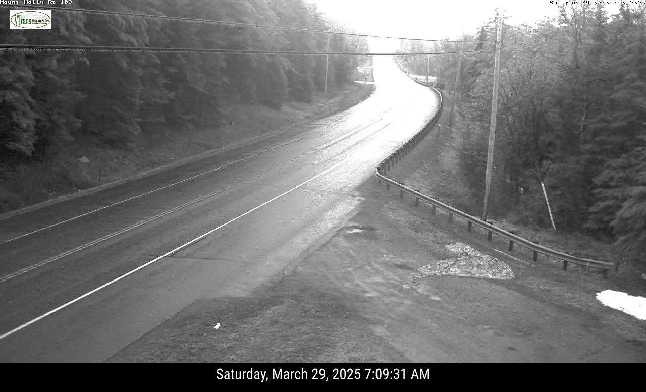
I noticed as of 7 a.m. Vermont traffic cameras showed trees along Route 7 in Brandon, Route 4 on Mendon Mountain and Interstate 89 near Bethel and along Interstate 91 in southeastern Vermont  beginning to sag under the weight of ice from freezing rain. 

Traffic cam image from Route 103 in Mount Holly, Vermont
shows freezing rain already accumulating on 
trees and power lines. 
The ice looked especially nasty in the trees and utility wires along Route 103 in Mount Holly. 

There were already some outages as of 7:30 this morning, amounting to about 1,000 customers, mostly around Brandon and Leicester.   

Far southern Vermont was getting rain or nothing at all early this morning. 

Needless to say, road conditions in central and northern Vermont are atrocious this morning. 

THE REST OF TODAY

Near and north of Route 2, the main action at least for now was this morning. The worst of the snow for today is over up there. It looks like those areas will get a bit of a break this afternoon and evening. 

A weak wave of low pressure riding along the stalled west to east weather front will go by to our east, and the front will slowly start to sink southward. Both those facts mean the heavy snow this morning will turn into just cloudy skies and maybe a little patchy light snow or freezing drizzle at times.

The fact the break will happen during the day is good. The strong spring sun should work through the clouds a bit. It won't melt all that snow we got early today, but it will at least help road crews get the highways in better shape. It might even briefly get above freezing in spots. 

Precipitation should continue today in central and southern Vermont, but even there, it will be lighter than it is this morning. Still, a little more freezing rain will continue to slowly weigh down trees and power lines in some spots. 

By late afternoon, most of the precipitation will be focused in far southern Vermont. 

After that, the front will stall again, then slowly start to lift northward again

TONIGHT

As the front slowly goes north, rain and freezing rain will start to move north with it.  This is where things start to get bad in central Vermont.  There could be a lot of freezing rain tonight and the first half of Sunday.

Broader valleys west will probably go to a cold rain fairly quickly on Sunday morning, but the the freezing rain will continue in the Green Mountains and valleys east of those mountains. 

Remember yesterday, I mentioned that you start to get a little tree damage and power line problems when you get a quarter inch of ice. You get to a half inch and the power lines and trees really get in trouble.

The latest ice accumulation maps from the National Weather Service depict a half inch or more of ice in the hills and valleys either side of Route 100 between about Weston and Rochester. There's even spot on the map northeast of Manchester drawn as having 0.75 inches of ice.

If you live in these areas especially, charge your devices today. You could be in for some lengthy power outages. 

The rain and freezing rain will continue north overnight and Sunday morning. In the Champlain Valley, it could be pretty icy early Sunday morning, but then we'll transition to a cold rain for the rest of the day. That rain will tend to taper off again during the afternoon and evening

In the colder hollows east of the Green Mountains all the way to the Canadian border, freezing rain could be a problem most of the day, though again, precipitation will tend to taper off during the later part of the day. 

SUNDAY NIGHT/MONDAY

Temperatures will continue to slowly warm Sunday night as scattered light showers linger.

Warm air still looks like it will surge across Vermont Monday, bringing us all well into the 50s and 60s for highs. 

It probably won't rain much until later in the day, when a cold front approaches. There could even some thunderstorms mixed in with this. In fact, on Monday, NOAA's Storm Prediction Center predicts severe thunderstorms up and down the east coast, and a marginal (very slight) risk of a severe storm extends all the way up into southwest Vermont.

It still looks like the rapidly melting snow and ice and the renewed rains Monday will bring river levels up, but so far it's still looking like if we get any flooding at all, it will be pretty minor. 

Stay tuned for more updates on this storm as we get 'em!  

Friday, March 28, 2025

Vermont/Surrounding Areas Still Girding For Nasty Snow And Ice Storm This Weekend

Latest snow forecast map issued by the National Weather
Service office in South Burlington early Friday. 
Map is through 8 p.m Sunday but virtually all the snow
you see here will hit late tonight and Saturday.  
Areas in yellow would see the most snow, with
at least six inches in those spots. 
One thing hasn't changed since yesterday's forecast:

Saturday looks UG-LEE in Vermont.  

We're still looking at a horrible mix of snow, sleet, freezing rain and rain that will last from late tonight through Sunday. 

SATURDAY'S MESS

Although overall forecasts have not changed much since yesterday, we really won't know who gets the heaviest snow and the worst icing until we're into the event.  

It all depends on where and how this wavering, pretty much stalled weather front sets up.

If forecasters are wrong on the position of the weather front by as little as 20 or 30 miles, then current predictions would be incorrect one way or another. It's virtually impossible to forecast the exact position of a sluggish warm or cold front, so that's why all the meteorologists are hemming and hawing about how much awfulness comes down from the sky Saturday and where. 

For now - again this could well change - it looks like northern Vermont from very roughly Route 2 north will stay with mostly snow on Saturday where four to eight inches of fairly wet snow would pile up.

Just south of that, we should see a band of mixed precipitation, including quite a bit of freezing rain. That ice is part of a lengthy band of freezing rain and schmutz that is or will be extending along a lengthy band from  northern Minnesota, through upper Michigan, across southern Ontario and on into Vermont, New Hampshire and Maine.  

Again though, don't be surprised if the snow and ice areas end up shifting northward or southward unexpectedly. 

Here in Vermont, the precipitation will come down pretty heavily at times.  Between the fairly wet snow, and the ice, I expect some power outages to develop here a there. 

And we know the roads will be atrocious.  

The latest ice accumulation forecast from the National 
Weather Service. This map could change drastically by
tomorrow, depending on shifts in the forecast
Areas in red are where at least a quarter inch of 
ice would accumulate. Once you get to a quarter
inch, you start to lose tree branches
and some power lines. 

Toward the end of March, when snow falls lightly, it can melt when it hits the pavement because of a higher sun angle allowing heat to penetrate the clouds. 

But snow and ice will be coming down heavily enough, from thick clouds, so that we won't really get a break from the early spring sun. 

Expect snow and ice covered roads all day, mostly but not exclusively in the northern half of the state. 

If you have to drive anywhere, do it today, as we're not expected any weather problems whatsoever until tonight. 

it looks like there will be a fair amount of plain rain during the day Saturday in far southern Vermont. 

But precipitation could begin as ice early Saturday, go over to rain, then switch back to freezing rain Saturday night as cold air temporarily bleeds southward all the way to near the Massachusetts border. 

SATURDAY NIGHT

That risk of freezing rain in southern Vermont Saturday night is because that front will drift southward overnight, flooding all of Vermont with chillier air from Quebec. Briefly, anyway. Precipitation probably won't come down all that heavily Saturday night, but those areas receiving a little more freezing rain will see a little more weight added to trees and power lines, so that could risk some trouble.

SUNDAY

That front will slowly lift back north starting early in the day. As it looks now, freezing rain will redevelop, but gradually change to a cold rain during the day.  Parts of  eastern Vermont might have trouble getting above freezing you get well into the afternoon 

That makes me worried about really thick accumulations of ice in a few locations by Sunday.  Once ice from freezing rain gets to be a quarter inch thick or more, you start to lose a few tree limbs and power lines.

Once the ice gets to a half inch thick or more, you really start to risk widespread tree damage and big time power outages. 

This morning's ice forecast maps from the National Weather Service - again, definitely subject to change - has a pretty wide area of central Vermont seeing about a quarter to maybe third of an inch of ice.  

Those maps also shows small, limited areas of Vermont with at least a half inch of ice.  But it's going to be a close call. We'll need to keep an eye on this in case some more widespread areas get a lot of ice. If it looks like we might see more freezing rain than expected, the winter weather advisory would be upgraded to an ice storm warning for a few sections of the state. 

Even where ice turns into a cold rain Sunday, the snow and ice won't immediately begin to melt all that fast. Temperatures will hold in the 30s most of the day, so the schmutz on the ground will just soggier.

We'll have to wait until later Sunday night and Monday to see any hint of a return to spring. 

MONDAY

Still looking weird. 

Temperatures - at least for awhile - will rocket upwards into the 50s to maybe some 60s as the rain continues and it turns sort of oddly humid for this time of year. The rain and the rapidly melting snow and ice from the weekend could lead to some flooding problems.  It's a little early to predict how much if any flooding we'll see. 

Rivers will certainly go up, but whether they spill their banks is an open question. But so far it's not looking too serous. 

There could conceivably even be a few non-severe thunderstorms mixed in on Monday. 

It's another thing to keep an eye on, though.

A sharp cold front Monday night will plunge us into the 20s, so all that remaining water out there will freeze up. At least by later Monday night the precipitation will have been mostly flushed away. 

After a cold for the season but bright Tuesday, another storm looks to come along by Thursday.  That one likely will turn out to be mostly rain, and probably not as big as the fun we're going to have this weekend. 

Monday, March 17, 2025

Monday Morning Vermont Storm Update: All Over Except The Flooding

Rising waters of the Missisquoi River in Enosburg Falls,
Vermont Sunday afternoon. The river, like others in 
Vermont, would later hit flood stage due to melting
snow and briefly heavy Sunday night rains. 

To be honest, we in Vermont only got the tail end of that incredible storm that left a trail of damage and death across much of the United States.  

Even so, the storm was so dynamic things got pretty impressive around here, with winds, weird temperatures, impressive storms and of course, flooding.  

In the warm air ahead of the storm, winds gusted as high as 60 mph in Burlington. 

The high temperature of 70 degrees in Burlington Sunday would have been a record high pretty much any day this time of year except yesterday. That's because it fell on the anniversary of a bonkers 78 degree reading in 1990.  

Sunday's low temperature of 50 degrees in Burlington was a record for highest minimum temperature for the date. The weather - aside from the wind - was typical for late May,  not mid-March. 

It was also pretty strange this time of year to see several severe thunderstorm warnings in the western Adirondacks and central New York. 

There was even a tornado warning or in central New York, around Oneida County and in northwest New York between Watertown and Massena. Very strange for March! 

Those storms "weakened" by the time they got to Vermont last evening, and lightning had pretty much disappeared from them, but they still packed a punch. Some probably very nearly officially qualified as severe. Part of the criteria of severe storms is for winds gusting to at least 58 mph. 

It had to come close to that when the storms roared through my area around St. Albans.  Power outages during the passage of the storm rose to about 3,600 in Vermont, though power had been restored to almost everybody by dawn. 

Damage reports include  a tree down across Interstate 89 northbound in Georgia. 

FLOODING

I'm burying the headline, though, as the real story is flooding. Several flood warnings were in effect this morning across Vermont. 

The most impressive - and I expected this - is along the Missisquoi River. The river is forecast to crest in  North Troy at around 11.9 feet, just shy of major flood stage.  Parts of Route 100 between Westfield and Newport and near Troy will be closed if it isn't already. Other low-lying roads along the Missisquoi all the way to Swanton will probably close, too. 

Missisquoi River at North Troy is forecast to flirt
with major flood stage today. 

The Otter Creek in Center Rutland is expected to flirt with moderate flood stage today. Low lying roads in Wallingford, Clarendon, Rutland, Proctor, Pittsford and probably north of there all the way to near Middlebury will certainly flood and be closed. If they're not closed already. 

The Winooski River at Essex Junction is also expected to reach flood stage today, so low lying and sometimes popular commuter roads in Bolton, Richmond and Williston might be under water or close to it. I'd avoid those areas

High water was also covering part of Route 118 near Eden and Belvidere. 

Other trouble spots include the Barton River near Coventry and the Ottauquechee River in southwest Vermont. 

Most other rivers in Vermont might or might not reach flood stage but they will be running very, very high today. 

This isn't a wholesale, awful disaster like we endured in July and December, 2023 and July, 2024, as I don't anticipate many buildings or houses suffering serious flood damage. 

But you'll want to re-think your traveling routes this morning if you ride takes you to any low lying roads. They could be under water.

And for gawd's sake, if the road is flooded, just turn around and go somewhere else. Most flood deaths are in cars.  Remember, even if you drive into a flood and are miraculously not swept away, the water is literally icy cold. And it's not that warm out, either. 

I noticed this morning that the the Vermont Urban Search and Rescue Team is on standby, staged in Moretown and Colchester in case there is need for any rescues. Pro tip: Don't create a situation where they need to rescue you.

On top of all that it's unusually dark out this morning with areas of dense fog, so you'll want to be careful even roads nowhere near any rivers 

THE FORECAST

It's much cooler today, but still it's nothing odd for March, In fact, it's a little on the warm side.  Rain showers will continue for at least part of the day, especially in eastern Vermont. But the rain should be light, and won't add much to the flooding. 

A new, fairly strong storm will bring us a new spell of balmy weather this week. This storm isn't nearly as strong as the one we just had, but it will be strong enough. It will cause a smattering of severe weather in the South and Midwest, along with more wildfires and possible dust storms in the central and southern Plains. 

For us, it will pump warm air northward, and we should reach the low 60s again in many valleys in Vermont by Wednesday and Thursday. 

The storm will swing another strong cold front through Thursday afternoon or night. We could be looking at more gusty storms with the front, depending on the timing and dynamics along the foot. 

The weather pattern looks like it will shift, at least for awhile behind Thursday's front. Temperatures should trend closer to normal for later in March, (Highs in the upper 30s and 40s, lows in the upper teens and 20s, give or take).  

We could still  have fairly frequent bouts of rain or snow during this new weather regime, but there's hope the storms won't be as extreme as the one we just had.  

Saturday, March 8, 2025

Snow (Temporarily) Rebuilding In Vermont Mountains; Flurried To Death Elsewhere

After a sunny day, traffic cams show a snow squall
hitting Interstate 89 in Williston shortly before 6 p.m.
It was brief, but left areas of black ice behind. 
Same situation could well happen in parts of
Vermont today. 
Vermont weather on Friday was certainly windy, with a wait a minute it will change character.  

So stereotypical of March, so there you go. Winds gusted as high as 63 mph at a  fairly  high elevation in Jay. Elsewhere, we had reports of 53 mph in Lowell, 51 mph on Colchester Reef and in Springfield and 49 mph in Alburgh and West Rutland. 

Almost everybody saw top winds in the 40 mph range. The gusts were enough to produce some power outages. The number of homes and businesses without power Friday peaked at around 2,400 shortly before 2 p.m. Friday. 

Also true to March character was the weather. It was bright and sunny in much of Vermont for a good chunk of midday. Then, as expected, those briefly sorta heavy, gusty hit and miss snow showers rolled in. 

I noticed Burlington got a quick. 0.7 inches of accumulation in a brief burst of snow late Friday afternoon. Traffic web cams showed highways in parts of Chittenden County getting iffy. There were quite a few reports of black ice, and a few slide offs and car  mishaps.   

NEXT UP

More of the same this weekend as a spray of small disturbances blow through from the west and northwest.

Snow prediction map from the National Weather Service
office in South Burlington through Monday morning.
Most of us won't get much, but some areas of the
northern Green Mountains, New York's Adirondacks
and New Hampshire's White Mountains could get
 a  decent six inches of snow out of this. 
None of these disturbances will be capable of bringing much snow. But it will add up in the central and northern Green Mountains, where a fresh four to seven inches should be on the ground in those high elevations by Monday morning. 

One of these little weather disturbances was putting down some snow showers mostly across  central Vermont early this morning. 

As of 6 a.m., it was snowing again a little in Burlington, though skies were clear overhead here in St. Albans. The hit and miss character of these snow showers continues. 

Judging from the traffic cameras, you might well encounter areas of snow covered roads and black ice this morning.  I'd take a little extra time getting to where  you are going early today because of this. 

Looks like new snow overnight ranges from less than an inch in the valleys to at least a couple inches in some of the mountains. 

Another hiccup in the wind flow overhead will bring central and northern Vermont another smattering of gusty snow showers this afternoon and evening. 

Much like Friday's snow showers, these will be hit and miss, and a few of them might contain very briefly heavy snow and gusty winds. Just enough to make it a little dicey on the road if you drive into one.

Today will stay windy, though not as bad as Friday. But it will be colder, with most places staying at or below freezing all day. 

After maybe a little sun Sunday morning, the next little weather thingy comes in from the west and northwest.  This will have a slightly better, more organized packet of snow showers with it.  Still, it will be light stuff. Most of us will see yet another dusting to two inches, with a little more in the mountains. 

SPRING, WITH INTERRUPTIONS

It'll start to warm up on Monday, and Tuesday should give us a brief treat of springtime temperatures. Many of us will see some sun and highs up in the low 50s.  Very nice!

Yesterday, I thought there'd be a little cold air oozing into northern Vermont Wednesday and maybe missing the south. 

Now it looks like that cold front from Quebec will blast on southward through the state, giving us a brief return to chilly conditions Wednesday. 

Then, it looks like a large storm will blossom somewhere in the central Plains next weekend. As it stands now, it looks like that storm will pump the warmest air of the spring so far into our region.  Early hint suggest it's even possible the warmer towns could reach 60 degrees in a little over a week.

Will be interesting to see if that comes to pass. As usual, spring will be coming to Vermont in reluctant fits and starts. 

Tuesday, January 28, 2025

Heads Up Vermont: This Morning's Commute Might Be A Slog. Wednesday Might Not Be Much Better

National Weather Service radar at around 5 a.m. today.
The green is fairly heavy snow. That smudge of dark green
and yellow southeast of Burlington is an intense snow
squall. The purple outline depicts a snow squall
warning that was in effect at the time of this radar image.
A line of ferocious snow squalls swept southeastward through northern and central Vermont this morning, dropping a quick inch or two of snow and turning wet or slushy roads into ice skating rinks just in time for your drive to work this morning. 

The squalls will keep heading into southern Vermont by around 7 or 8 p.m., so that part of the state will deal with poor visibility and rapid changes in road conditions.

The squalls might weaken just a tad by the time they reach southern Vermont, but will still be dangerous. 

Meanwhile, the aftereffects of the squalls will be the main problem north of Route 4. Temperatures just after midnight were a little above freezing in many areas. The initial bits of snow just ahead of the snow squalls melted into water on many roads.

Then the snow squalls hit with rapidly falling temperatures and heavy, wind driven, blinding bursts of snow. That water on the roads froze, then snow fell on top of it.

The snow squalls were moving fast enough to only leave an inch or two of new snow in most areas, but that was more than enough to make the roads slick. 

I noticed road crews were out here in St. Albans shortly after the worst of the squall had passed and I'm sure that will be true everywhere else in Vermont.  But there's only so much they can do with crashing temperatures. 

Main roads might improve some through the morning commute, but they won't be entirely cleaned up.

Take it easy, take it slow early this morning. 

This Afternoon

The good news is the snow showers will be out of here this afternoon and roads should be in pretty good shape. Expect a cold day. As noted, we already had our high temperatures for the day. It'll stay in the teens all day if we're lucky and a stiff north wind will make it feel like it's below zero.

But there's no rest for the weary.  Tomorrow's trip to and from work won't be fun either.

Wednesday.

National Weather Service snowfall forecast through 
Thursday morning. Almost all the snow predicted is
from an Alberta clipper storm coming through on
Wednesday. Most of us can expect two to four
inches of fluff on of this one. 

We're on a temperature roller coaster as several quick weather systems come through with snow or even something else possible on Friday. But we're getting ahead of ourselves.  

The crash in temperatures will halt later this evening as an Alberta clipper comes in with clouds and snow. 

Alberta clippers are those fast moving storms that come in northwest to southeast from near Alberta, through or north of the Great Lakes then into our neck of the woods.  

Temperatures will moderate into the 20s tomorrow, but it will also snow pretty much all day. 

The snow will get here before dawn, and it will still be on the cold side in the morning. 

Even though the snow will be coming down lightly, it will still stick effectively to the roads. The plows will be out but it'll be a slow commute once again. The trip home in the evening will feature light snow, too, so even that won't be so great. 

Most of us can expect about two to four inches of fluff out of Wednesday's system, with a little more than that in the mountains. 

Behind this little snowfall, the temperatures will crash once again, getting down to near or even a little below zero by Thursday morning

Thursday And Beyond

The roller coaster continues big time. A break in the weather comes Thursday afternoon as sunshine returns (hopefully) and temperatures mostly stay in the teens. It looks like temperatures will actually start to rise overnight Thursday ahead of our next quick hitter. 

Friday is a wild card.  Another Alberta Clipper will be coming in from the west, while what was the rain storm that tamped down the Southern California wildfires lurks to our south and heads east toward the Atlantic Ocean,

The Friday Alberta clipper might suppress the wetter, southern storm to our south so that it misses us. Or, the clipper  might help draw the southern storm closer to us, giving us somewhat heavier precipitation.

 We don't know yet. Friday will probably be warmer again, possibly near freezing. But we don't know whether we'll see just a little snow and a few raindrops or a somewhat more substantial storm.

Watch this space for updates.

Then, once again, temperatures get frigid again Friday night and Saturday. Then, rinse and repeat as yet another Alberta Clipper comes in next Sunday and Monday with another modest warm up and probably another couple inches of snow. 

I did say in yesterday's post that the weather pattern around here was finally getting a little more exciting, and all this is your proof.