Wednesday, May 31, 2023

Tonks, Our Gracious, Zen-Like Loyal Companion And Weather Watching Dog, Dies At 16

The late, great Tonks in her St. Albans, Vermont yard on
a breezy winter day in 2017, enjoying the scents in the air.
Tonks Modereger Sutkoski, our gorgeous furry sweetheart, crossed the Rainbow Bridge today, May 31, 2023. She was 16.   

Tonks was a gracious, zen-like presence who taught us all to savor the simple things in life, like a comfortable bed and the smells and sounds of nature outdoors. And meal time. Don't forget that. 

She was the beneficiary of great genes, making her a stunningly beautiful pup.  She was a Golden Retriever and Cocker Spaniel mix.  That gave her luscious blonde hair, soulful eyes, fun floppy ears and a cute button nose. 

Tonks came into our lives when she was seven years old. In the first chapter of her life, she lived with a Vermont couple, who eventually formed a family that included two very active, very young children. The couple knew the kids were probably too much for Tonk's gentle, calm nature. 

The family generously and selflessly let us adopt Tonks, who quickly settled into a new life with goofy brother Jackson and her new parents Jeff and Matt. 

Tonks in the foreground enjoys a laugh while her 
brother Jackson in the background not getting the
joke on a sunny autumn day in 2015. 
Tonk's new household had gardens, lawns and decks where she was free to roam. She quickly got in the habit of sitting down, facing the wind, closing her eyes and enjoying all the aromas that passed her way. Sometimes Jeff or Matt would join her in this activity.  

 She also enjoyed laying down on the deck and watching the cars on the road zip by, and the birds flutter around overhead. 

Tonks was no loner, though. She loved visiting people when they stopped by, accepting with pleasure a little neck scratch and just the companionship she enjoyed when human friends were around. 

 Every day, breakfast and dinner were cause for big celebration. After these daily feasts, she'd settle down in the soft bed she loved for comfortable naps. 

Another particular joy for Tonks came in the summer, when it was time for dad Matt to thin the carrot crop in the raised beds. She and brother Jackson would safely dispose of the delicious mini-carrots Matt would dig up by immediately chowing them down. The carrots were her favorite food.

Tonks enjoying a rest on her comfortable bed, 2019.
She, accompanied by her brother, would also always help Matt measure whichever weather event came our way, so that Matt could do a more accurate write-up in this blog. 

She especially loved weather watching with Matt on sunny, windy days.  However, Tonks was not a particular fan of snow, especially if it was deep.  

Tonks, always the helpful pup, was our early warning system for any truck deliveries that appeared in our driveway. She'd hear the beep-beep-beep of the truck backing up, and start barking loudly to announce the delivery arrival.  

She was also a  bit of a prankster. As her dad Jeff settled into his easy chair to watch TV in the evenings, Tonks would quietly slip into the hallway behind him. After awhile, she'd let out a single loud bark, propelling Jeff to the ceiling.

In Tonks' later years, her hearing diminished and her hind legs grew weak and unstable. But she never gave up her curiosity, and that zen-like life of smelling the aromas in the air continued until the end. 

Tonks, left, and her brother Jackson, help dad Matt
with his weather blog by sniffing the air for clues as to
when the snow would stop during a
large 2018 winter storm
Tonks is survived her her brother Jackson, dads Jeff Modereger and Matt Sutkoski of St. Albans, and many aunts, uncles and cousins. 

She was predeceased by her loving grandparents Don and Lois Modereger of Yankton, South Dakota and Henry and Pauline Sutkoski of West Rutland, Vermont. 

In lieu of flowers, Tonks asked that you make a contribution or volunteer at your local Humane Society. She also said that if you want to add another doggo to your family, please consider adoption. 

Tonks passed away in late spring, probably the most fragrant time of year for many of us. She asks that you go outside, sit down facing the wind, close your eyes and breathe in the wonderful aromas of nature.

 It was Tonks' way of doing things and being happy, and this works for humans, too. 

Tuesday, May 30, 2023

Wildfire Smoke And Record Heat Loom In Vermont This Week

One of the large wildfires burning in Nova Scotia on Monday.
 Ahh, yesterday, Memorial Day, was much better than Sunday in Vermont weather, at least in my opinion. 

Both days featured wall to wall sunshine, but as expected, Monday was quite a bit cooler.  Highs made into the 70s instead of the upper 80s, and a breeze kept the dry air refreshing. That near constant wildfire smoke up in the atmosphere from Canadian wildfires was at a minimum, too.

So much for that. It's back to possible smoke and definite heat for the upcoming week. 

Today won't be so bad, as temperatures climb into the low 80s amid more sunshine and dry air.

The weather pattern is frankly wonky, so things won't be acting the way they should during the middle of the week. We normally expect weather systems to move generally west to east in our neck of the woods. 

But this being a weird spring, we can't have that!  So, we face the risk of smoke coming in from the east, and record heat moving north to south from, yes, chilly Canada of all places. 

SMOKE

First, the smoke risk. It's not as definitely in the forecast as the heat, but it's still pretty likely.  As you might have heard on the news, there's some terrible wildfires in New Brunswick and especially Nova Scotia, Canada. 

Two large wildfires are burning in Nova Scotia. One, west of Halifax, has forced the evacuation of 16,000 people and damaged or destroyed at least 200 homes and other structures so far. 

Another, larger fire was burning in the a less heavily populated area near the southern tip of Nova Scotia. 

Large smoke plume seen on satellite photos
on Monday coming off of Nova Scotia. The smoke
eventually turned east toward New England.

At last report both fires were still out of control. A third large fire also reportedly broke out in Nova Scotia Monday. 

Amid a normal weather pattern, all that smoke from Nova Scotia would head eastward out into the open Atlantic.

Instead, there's warm high pressure over southeastern Canada. That's creating east winds on the southern edge of that high pressure to propel the smoke eventually toward New England. 

It looks like it will hit southern New England today, then slowly curl northward into northern New England, including Vermont later tonight and tomorrow. 

For most of this month, the smoke we've seen from even bigger fires up in Alberta, Canada have been high aloft. It created hazy skies, but no real air pollution problems from us down here on the ground. 

The Nova Scotia smoke will be closer to the ground, so you might actually smell smoke and we could see some air quality problems. The smoke looks like it will be more dense in southern New England and dissipate somewhat once it gets here. 

The smoke will tend to clear out at least somewhat by afternoon, which leads us to the heat wave.

RECORD HOT?

Temperatures should soar to the upper 80s Wednesday afternoon. Both the ground and the air are very dry, so that tends to make hot spells over-perform. So I wouldn't be surprised to see a few more 90 degree readings than currently forecast. The record high tomorrow in Burlington is 91 degrees, so we'll come close. 

Thursday looks to be the hottest day. The record high on Thursday in Burlington is 90 degrees, set in 2011 and tied in 2013.  The National Weather Service office in South Burlington gives us about a 90 percent chance of breaking that record.  

Friday looks hot, too, with an expected high near 90 degrees.

As mentioned, this is a weird hot spell. The hottest air has built up inside a persistent stubborn, strong heat ridge in southern Canada. The core of the hottest air will ride the northern edge of this ridge, then come down on us from Ontario and Quebec. This, of course, is normally where our cold spells come from.

Also, unlike a "normal" heat wave, the air will be quite dry, which will help exacerbate the building drought conditions we're experiencing. 

Go figure. A cold front later Friday should touch off some showers and thunderstorms. But they will be kind of scattered, and not last long in any given area. So we won't get much needed rain out of this. 

By the way, it's not just Nova Scotia that is at risk for more forest fires. There's a high fire danger in Vermont all week due to the dry heat we're experiencing.  So be careful with any flames, please! 

Monday, May 29, 2023

Vermont Weather Week: Gorgeous! But Flash Drought Worries Increase

My gardens in St. Albans, Vermont are thirsty and getting
thirstier in this remarkably intense dry stretch,
but at least my cactus looks happy. 
Exactly as forecast, this Memorial Day weekend in Vermont  has brought us gorgeous weather. 

I don't think I've seen a single cloud since Thursday.  (A narrow band of broken clouds came through last night, but I slept through that).  

Sunday brought us the warmest temperatures of the year so far. Burlington got to 89 degrees, just three degrees off the record high set in 1978. A few spot 90 degree readings showed up in the lower Connecticut River Valley. 

When the air is super dry, it can warm up fast in the strong late May sun, so that's why temperatures over-performed Sunday.  The relative humidity was in the low teens in many areas, which is as low as it can possibly get in this neck of the woods, really.  . 

The hot sun and dry air are really drying things out fast.  I'm spending lots of time irrigating my gardens, and it's still a bit of a dust bowl. At least the cactus I have is happy. 

THE WEATHER SET-UP

For sun lovers, if you liked Sunday, you'll pretty much love the rest of the week. For those of you worried about it getting too dry, this won't be your week. 

We've been stuck in a pattern since mid-May at least of a series of dry high pressure systems propelled southward from northeastern Canada. We've had a series of so-called "back door" cold  fronts come through. 

Back door cold fronts are called that because they come in from the north and northeast, rather than from the west or northwest like they usually do.

These back door cold fronts are moisture-starved, so we get little or no rain with them. One of the high pressure systems gave us that destructive freeze mid-month. Another cold one brought more frost last Thursday. 

The back door cold fronts keep coming, but now, the bulk of the cold air is passing by well to our east and northeast, so it's not getting chilly. But staying dry. 

 THE DETAILS

That narrow band of broken clouds I mentioned that came through overnight was yet another "back door" cold front. 

Visible satellite photo from Sunday afternoon shows
clear skies throughout New England except northern
Maine. That narrow band of clouds from the tip
of Maine into southern Quebec is the dry back door
cold front that eventually came through last night. 

It will much colder today than Sunday, but that's not saying much.  Instead of being in the 85 to 90 degree range, most of us will hold in the 70s. A few hot spots might break 80.

The air will remain bone dry.  Dry air allows temperatures to rise rapidly during the day, but also allows those reading to crash at night. Tomorrow morning. the coldest hollows will probably be down to about 35 degrees, a lot of us will be in the 40s and the banana belt towns will hold near 50.

Warm and dry weather returns Tuesday afternoon with highs in the low 80s. 

Wednesday and Thursday, and possibly Friday is when the heat will really turn on.  Places like Burlington, which have come this close to reaching 90 without getting there this spring, have a very good shot of finally getting that hot. 

Unlike the typical 90 degree weather in Vermont, which tends to be humid, the air will remain quite dry during this hot spell. 

Another back door cold front will come through later Friday, but again it will be starving for moisture. It might generate a few hit and miss showers and thunderstorms, but no real drenching. 

At this point, next weekend is looking generally sunny, very dry, and a bit cooler, but by no means chilly

DRY WORRIES

The U.S. Drought Monitor doesn't yet have any part of Vermont in a too-dry or drought category, mostly because ground water is still in pretty good shape after a fairly wet start to the year. 

But the top several inches of soil has dried out big time, so we might be headed toward a drought, given the lack of rain we've had and the dry forecast. Burlington, for instance, has had only 0.64 inches of rain since May 4. We should have had roughly three inches of rain during the time.   With no rain this week, the dust will keep collecting. 

If this keeps up, the hay crop for feed in Vermont might end up being not great. So far, so good, but it had better rain after this week. (Long range forecasts are iffy on that prospect).

Another issue is forest fire danger. Trees have leafed out, so the risk isn't as bad as it was in April, when all the dead stuff from last year was drying out. Still, the fire danger in Vermont is moderate to high today, and that state of affairs should continue all week.

This fire danger is a regional problem in New England and southeastern Quebec. On Sunday, large wildfires broke out in Nova Scotia and New Brunswick. 

These are big-time, western-style fires. Thousands of homes were evacuated Sunday northwest of Halifax, Nova Scotia and some of those homes were destroyed by the flames. As on this morning, that fire is still raging.

We don't expect anything like that here in Vermont, but still, please be extra careful with your camp fires, cigarettes and burn piles. 

Sunday, May 28, 2023

Video: A Garden Gets A Drink Of Water Before Another Long Dry Spell

Water beads on plant leaves after the last rain we had
on May 24 in St. Albans, Vermont. Video in this
post shows a garden and trees enjoying 
some gusty rain showers. 
 A quick hit this morning, just a video showing a grateful garden in St. Albans, Vermont getting a little drink of water from the sky this past Wednesday. 

It's been dry lately and getting drier. We got about a third of an inch of rain Wednesday, which isn't much, but we'll take anything we can get. 

Since Wednesday, the air has been bone dry with wall to wall sunshine. This state of affairs is pretty much expected to continue through Thursday at least. 

We have a shot of a few showers at the end of the week, but whatever comes does not look at all impressive, at least according to the latest forecasts. 

The gardens are getting pretty dusty, and I'm spending a lot of time on irrigation lately.  I guess that will continue all week with warm to hot temperatures and continued very low humidity. 

Eventually, it will rain again. There are hints in the long range forecasts of possible cooler, somewhat wetter weather in the second week of June. We'll see about that. 

Meanwhile, we can watch the video as sort of a rain dance for our Vermont gardens and farms. The rain and wind kind of made look like the trees and gardens were dancing. 

At the end, the sun comes back out for a quick evening visit. 

Click on this link to watch the video if you don't see the image below. Otherwise, click on the image below to watch: 


Saturday, May 27, 2023

Hurricane Season Forecast Issued; A Really Complicated, Iffy Forecast

Satellite view of Hurricane Ian about to make landfall
in southwestern Florida last year. The number of
expected tropical storms and hurricanes this
year is really a tossup, according to forecasters. 
NOAA released its official hurricane season forecast on Thursday, and there are a lot of ifs and maybes win that prediction. 

There's two opposing forces going on in the Atlantic this year. One factor could give us a lot of hurricanes, but another factor could give us a lighter year than in the recent past. 

NOAA is pretty much splitting the difference, calling for a near-average hurricane season. 

On one hand, El Nino is developing, and that tends to help squelch hurricane activity in the Atlantic. On the other hand, thanks in large part to climate change, the Atlantic Ocean is much warmer than historical averages, and is expected to stay that way all summer and early fall.

Warm water tends to encourage more hurricane development. So the question is which will win out?

NOAA's annual hurricane forecast gives what they believe are the percentage chances of an above normal, quieter than average or typical hurricane season. This year's version really shows what a tossup the season is. 

NOAA tells us there's "a 40% chance of a near-normal season, a 30% chance of an above normal season and a 30 percent chance of a below-normal season."

Yeah, that doesn't tell us much.  I guess the prospect for Atlantic hurricanes this year is anybody's guess.

For the record, NOAA says we should expect 12 to 17 names storms (ones with winds of 39 mph or more) and five to nine of these would be hurricanes, with winds of 74 mph or higher. One to four of these would be major hurricanes with winds of 111 mph or more.

NOAA says it has a 70 percent confidence in these numbers. Again, pretty uncertain. 

Hurricane seasons in the past six years or so have been super active in the Atlantic Ocean, with several devastating hurricanes. Last year, two of them, Hurricane Fiona and especially Hurricane Ian, caused billions in property losses in Puerto Rico, Canada and Florida. 

Other hurricane forecasts for this year in the Atlantic Ocean vary. The British Met Office predicts a busy year, with 20 named storms, compared to an average of 14. The Met Office expects around 11 hurricanes, with around five major hurricanes. 

Colorado State University also issues closely-watched Atlantic hurricane forecasts. They're predicting a comparatively light storm season, with 13 named storms and six hurricanes. 

The two opposing forces - El Nino and the warm ocean water, could create a lot of nuances in the hurricane season. It's possible the warm water will generate lots of relatively weak, disorganized tropical storms that don't last long. Strong upper level winds generated by El Nino could rip them apart.

Or, the opposing forces could just re-arrange where the severest storms form.  As the Associated Press reports, University of Miami hurricane research Brian McNoldy says it's possible that El Nino would suppress hurricane activity in the Caribbean, but shift more activity northward to near Bermuda and the U.S. East Coast.  

Whatever the number of tropical storms and hurricanes we see this year, remember, it only takes one to really strike a catastrophic blow. 

An often used example is the year 1992. Overall, it was a very quiet year, with just seven tropical storms, hurricanes or sub-tropical storms. But one of the storms was Hurricane Andrew, a Category 5 monster with 175 winds that devastated much of South Florida. It directly caused 26 deaths and $25 billion in damage. 

Also, note that places that were struck by severe hurricanes in recent years have not yet fully recovered. .Any new hurricanes striking the same areas would be especially catastrophic.

Given all the uncertain hurricane forecasts out there, we'll just need to hope for great luck with these storms. 


Friday, May 26, 2023

Last Frost For Most Of Us, Now Welcome To A Vermont Summer

This St. Albans, Vermont garden escaped any frost this
morning, so it looks like those irises and peonies
will bloom just fine in the coming days. 
The National Weather Service nailed it with a precise forecast that outlined who in Vermont would see frost this morning and who wouldn't. 

Frost was pretty widespread in most valleys of Vermont, with the Champlain Valley being a major exception. That was in line with forecasts issues yesterday, which indicated this would be the case. 

The coldest temperatures I could find were the usual suspects: 28 degrees in Island Pond and 27 degrees in Saranac Lake, New York. Many places were right around 32 degrees or just above it.

This morning's chill wasn't as bad as last week's devastating freeze, so I don't expect much additional crop damage from this morning's frost. 

With this morning's nippiness out of the way, welcome to summer. 

True, the very coldest hollows could see another light frost tonight, summer is indeed coming on full force, just in time for the Memorial Day weekend. 

Today will still be a bit on the cool side for late May, with highs only in the 65 to 70 degree range. But sunshine will make it feel toastier. 

The strong warming trend continues forward, with upper 70s tomorrow, readings near 80 Sunday through Tuesday, then probably in the mid to upper 80s midweek. 

For those participating in the Vermont City Marathon in Burlington Sunday, you'll have to deal with some pretty rapidly shifting temperatures. Temperatures will probably be in the mid-50s at the 7 a.m. start time, then rapidly zoom upward through the 60s and 70s through noon.  

Humidity will be low for the race, which is great for the runners. Strong sunshine I hope will mean plenty of sunscreen use among competitors and spectators. 

The only negative for all this is the fact that I still see almost no chance for needed rain between now and next Thursday, and possibly beyond that. 

Thursday, May 25, 2023

May 18 Frost Was Likely A Big Agricultural Disaster For Vermont/Northeast

The remains of frostbitten ash tree leaves in
Huntington, Vermont on May 21. A freeze three
days earlier caused a Vermont agricultural disaster.
It's becoming clear that last week's record setting freeze in Vermont severely damaged the state's apple, blueberry and other fruit crops, and hit vineyards hard, too.  

Though it can take days or even weeks after a big freeze to figure out damage to crops from apples to grapes to blueberries, the grim news is becoming apparent. 

As Vermont Public reports, quoting Terence Bradshaw, associate professor at the UVM Extension Fruit Program: 

"'In my 25 years of working with fruit crops in Vermont, I have never seen frost or freeze damage this extensive," Bradshaw said in a press release the Agency of Agriculture, Food and Markets sent out Tuesday. 'We expect a difficult season for growers and appreciate the continued support that our community provided to these vital operations that are so important to the Vermont agriculture community."

I smell a disaster declaration coming for Vermont and surrounding areas because of the freeze.  Vermont Agriculture Secretary Anson Tebbetts is urging farmers to keep track of their losses to help with possible federal aid. 

If the freeze prompts a federal disaster declaration, that would be the second weather event within five months to put parts of the Green Mountain State under such a designation. 

The storm that swept through much of the nation, including Vermont on December 22-24, 2022 prompted the disaster declaration for eight Vermont counties. 

The freeze last week was a sort of "perfect storm".  A very warm spring prompted a wide variety of fruit trees and plants to bloom earlier in the season than most people can remember.

The leaves on this ash tree in Huntington, Vermont were
black and shriveled three days after a devastating
May 18 frost in Vermont and the Northeast.
Then, a quick hitting blast of frigid air, lasting less than two days, crashed southward into New England, causing record low temperatures on May 18.  Virtually all of Vermont except areas very close to the Lake Champlain shore fell far below freezing. There were some reports of temperatures getting into the upper teens, with many reports of readings under 25 degrees.  

Temperatures of about 29 degrees or lower while fruits and vegetables are in bloom or starting to set pretty much guarantees damage. The further it goes below 29, the worse it gets. 

As Vermont Public reports, Tebbetts visited Shelburne Vineyard, among other farms, and saw extensively damaged grape vines. Owners of the vineyard don't know yet whether the vines are so damaged that they might not ever recover for future years. 

Tebbetts said he is worried about a range of crops that could have terrible damage. "The losses caused by the late spring frost is heartbreaking of those who produce fruits, produce, berries and wine," Tebbetts said in a press release issued by his department. "The hard freeze will mean significant losses for our growers and those who make their living off fruits and vegetables. The extent of the damage may  not be known for several weeks, but early indications are discouraging."

Green Mountain Orchard in Putney suffered what they call "catastrophic" damage to their apple crop.  Blueberries are also damaged, However, some blooms on the blueberry bushes looked at least partly intact and bees were working over them after the frost, so there is some hope 

It's been a tough year.  Peach trees can't handle super cold weather in the winter. In early February, it got  down to 18 below in Putney, ruining any prospects for a peach crop this year. 

I checked around the social media accounts of several orchards and berry farms around Vermont but none that I found had posts from the day of the freeze or after.  These farmers probably don't know the extent of damage yet, don't want to talk about it, and don't want to mislead their customers with information that might later turn out to be inaccurate. 

I bet that blueberries, strawberries, apples, wine and other Vermont goods will be harder to come by as the year goes on, and be more expensive if you do find these goods. Problems with wine production could last a few years. 

The freeze takes both a financial and emotional toll on farmers. Crop insurance would only cover some of the loss. And nothing solves the worry and despair this kind of thing causes. 

As VTDigger reports:

"On the morning after the frost, growers at Scott Farm Orchard in Dummerston surveyed the property, orchardist Erin Robinson said sitting beside apple trees that were limp and glistening with ice. 'It is the most brutal feeling to love something os deeply and be so powerless to protect it,' Robinson wrote in an Instagram post. "

 Orchardists try to find optimism.  They note that many of the apples are dead this year, but the trees that supply them are fine and will produce more apples in future years. 

Frost damaged leaves on a magnolia tree in
Williston, Vermont after the May 18 freeze. 

Other crops should be fine. Hay for feed seems unaffected, though a possible developing drought in Vermont could mess things up there. Corn really hasn't been planted yet, so that'll be OK.  

Most plant nurseries and garden centers seemed to have been able to protect their stock. I'm not sure how CSAs are doing, but I have a feeling they'll mostly recover.

As you can see in the video in the bottom of this post, the freeze killed leaves on certain trees, mostly oak, ash, locust and sumac.  In most places around the state, hillsides remain green, despite a few bare and brown patches left by the frost. 

Although the spring freeze might have been severe enough to damage fall foliage prospects in a few locations around Vermont, I'd say 95 percent of the landscape should be fine for tourists. Barring some other unforeseen misfortunate, that is. 

Unfortunately, this Vermont agriculture disaster is consistent with the effects of climate change.  A too-warm spring got buds and fruitlets going too soon.  The climate is also more prone to "weather whiplash" than it once was, so we got a nasty cold spell.

Obviously, I can't draw a direct line between the freeze and climate change, but the circumstantial evidence is there. 

Tonight, another weird late season frost is forecast in Vermont. It won't be as severe as last week's freeze, but it surely has farmers and orchardists wondering how much more than can take. 

VIDEO

Images take around Richmond and Huntington, Vermont three days after the freeze show damage to leaves on trees, mostly oak, ash, locust and sumac.  These trees are expected to sprout replacement leaves and be OK, but some trees that are already stressed might have trouble recovering.

The leaf damage is pretty striking, as you'll see.

Click on this link to watch the video if you don't see the image below, or if you do, click on that to view: 


Another Frost Risk In Vermont Tonight, As If We Need It

Water beads cling to a plant in St. Albans, Vermont 
Wednesday evening after a little rain. A frost risk
tonight and very dry weather will continue to
challenge Vermont gardeners and farmers. 
 Frost advisories are flying for all of Vermont except the Champlain Valley for tonight as another blast of late season Canadian air is now entrenched in the Northeast for another day. 

The National Weather Service in South Burlington is awaiting more data today to decide whether or not to expand the advisory into the Champlain Valley, so most of us are at risk. 

This is not what we need, given the apparent extensive damage from last week's frost. 

I'll have much more on that issue in a separate post later this morning. That upcoming post will explain why I suspect at least parts of Vermont will be declared a disaster area because of the freeze damage.

The cold tonight won't be as bad as last week's record setting chill. But with many fruit crops already damaged, this isn't great news. I don't think additional damage will be that severe, at least I hope, as most places should stay above about 30 degrees. 

But remember: It doesn't have to officially get down to 32 degrees for frost to damage sensitive plants. Temperatures are typically measured five feet or so off the ground. On clear, calm nights like we anticipate tonight, it can be much colder around our toes than it is around our head and chest. It could be 35 degrees where your arms are checking the thermometer and 32 degrees down where your tomato starts are freezing. 

The sun re-appears Wednesday evening in St. Albans, 
Vermont after a cold front dropped about a quarter
inch of rain, which isn't much. Next up: A frost
risk in Vermont tonight and more dry weather. 
For most of us, this will very likely be the last frost and freeze of the season, except in the normally coldest hollows. Which will probably have a frost tomorrow night, too. But the rest of us will be safe.

If you get through tonight's frost risk, everything will be fine in your garden or on your farm, except for more looming dry weather. 

The rain that came with yesterday's cold front wasn't all that impressive. Most of us got a quarter inch or less. It amounted to a small sip, but not the drenching we need. I even noticed last evening the soil was still dry under the thickest foliage in my garden. 

Things will continue to dry out rather ominously.  Absolutely no rain is in the forecast through next Tuesday, and probably beyond. 

We are also set to start a strong warming trend.  By Sunday, temperatures should top 80 degrees, and by Tuesday or Wednesday, we could see some upper 80s. 

The sun will stay out through this time (except at night, of course) and humidity will stay pretty low, which maximizes drying. It's going to be pretty dusty around here by the early and middle parts of next week. 

I still think we might be headed for a drought. We're not there yet, but we'd better have some nice soakers as we get into June. 

Wednesday, May 24, 2023

Vermont Somewhat Cheated On Rain Again, Another Frost/Freeze Threat And Dry, Warm Days Ahead

Haze, largely from Canadian wildfires, obscured this view
of the Adirondacks from South Burlington, Vermont on
a warm afternoon yesterday. A sharp cold front today 
will clear the smoke, but introduce another
frost or freeze risk to parts of the state. 
Not nearly as bad as last week's freeze, though. 
 It looks to me like forecasters have backed off somewhat on the amount of badly needed rain we'll get today from a powerhouse cold front that was on our doorstep as I wrote this after 8 a.m. today. 

The front will move through fairly quickly, not lingering long enough for us to get much rain. Current forecasts are from about 0.15 inches to maybe locally as much as a third of an inch. In other words, not much.

After today, it probably won't rain again for another week. So the dry weather and incipient drought continue to develop in the Green Mountain State. 

As if the state's agriculture hasn't taken enough hits with the weather this spring. 

By this afternoon, it'll feel like March, not late May.  We had a mild start to the day, with temperatures in the 50s for the most part.  By mid to late afternoon, most of us, especially in central and northern Vermont, will be in the 40s. For comparison, it should be close to 70 degrees that time of day, this time of year. 

That leads us to tonight.  Another cold one is on the way, but thankfully, it doesn't look like it will be an intense or as widespread as the destructive freeze Vermont suffered last Wednesday night and Thursday morning. 

It appears the Champlain Valley is largely safe. And instead of low to mid 20s in much of the rest of Vermont like last week, we're talking less threatening low 30s. It will be dry and breezy late tonight after the showers clear, so the risk would be freezing temperatures in spots, but not frost, which forms on calm nights. 

Still, the type of mass rush of cold air we're getting later today can be surprising, so it's possible the freeze might be slightly more widespread than this morning's forecast indicates. So protect sensitive plants to be on the safe side. 

You'll need to do the same tomorrow night.  Thursday will be blustery and partly cloudy, with highs in the 50s to maybe near 60 in the banana belt towns.  That's a good 15 degrees colder than normal.

That sets up lows in the upper 20s to mid 30s in much of the state away from Lake Champlain tomorrow night. 

Fingers crossed, that will be the last frost threat of the season for all of us except those in the very coldest hollows (Which can see frosts almost any time of year).

The good news is it's going to warm up to the point it feels like summer. The bad new, it looks like no rain is coming for awhile.

For a time, some forecasts indicated an upper level low would meander near us over the Memorial Day weekend, which would give us a shot at some showers.  Now, warm high pressure looks like it will dominate. That means a stretch of weather with highs near  or even a little above 80 degrees starting Saturday and possibly continuing through at least next Tuesday. 

Summer weather looks to arrive just as the unofficial start to the season gets underway. 


Tuesday, May 23, 2023

Fascinating "Smoke Front" Over Vermont On Monday

A "smoke front" over New England Monday.
North of Route 4 in Vermont and New Hampshire, it
was clear and bright. South of that rough line,
it was hazy from smoke aloft. 
Just a quick post today, building on what I called the "smoke front" that I mentioned was in southern Quebec Sunday.  

It was a fascinating feature that moved south into Vermont on Monday. North of this "front" it was crystal clear. South of it, not so much. 

I personally don't like it when that smoky haze builds up in the atmosphere. I love what I call classic Blue/Green days, and I look forward to them each year.  

Which is what we had in northern Vermont Monday. The sky was a dazzling, deep, crisp blue. The green trees shimmered in the bright sunshine and light breezes.

Just a gorgeous day. The smoke was gone, at least for a little while. 

But it wasn't far away. A visible satellite photo from Monday afternoon illustrates this. Click on the satellite photo to make it bigger and easier to see.

Far northern New York, northern Vermont, northern New Hampshire and Quebec was clear and bright.  However, there was a sharp dividing line through Rutland and Windsor counties, south of which the smoke remained. 

Click on the satellite photo to make it bigger and easier to see.

That sharp line had been over southern Quebec Sunday, but moved south. 

Crisp, clean blue skies and bright sunshine north of the
"smoke front" on Monday afternoon in St. Albans, Vermont
This "smoke front" was really a cold front that sort of washed out as it hit southern Vermont. You could tell by the temperatures, too. It was only in the low 60s across northern Vermont Monday but in the low 70s south. 

The smoke, of course, is coming back, so it was a short reprieve. The skies over northern Vermont were still nice and blue this morning, but this morning's satellite views show that "smoke front" getting more diffuse and the high altitude haze heading north and east again. 

South winds ahead of a strong cold front that is due tomorrow will ensure the smoky haze will last at last until the cold front comes through. 

Lucky for us, the smoke has stayed mostly aloft all this month, so we haven't had any real health issues with this, like other parts of the nation have. 

There's still a lot of smoke drifting over vast areas of North America, and the Alberta fires are still raging. 

Smoke forecasts say it will be hazy over Vermont by noon today, and stay that way into tomorrow. That next strong cold front on Wednesday should clear us out nicely for a sunny, bright, but cool Thursday.

Those smoke forecasts do have all that atmospheric smoke over North America dissipating somewhat over the next several days, so maybe we'll have at least a temporary break from the hazy skies as we move toward the end of the month. 

Monday, May 22, 2023

Slight Uptick In Rain Hope In Vermont, But Comes With A Bit Of A Price

A fast moving gusty, quick downpour approaching
South Burlington late Sunday afternoon. A sign
that summer thunderstorm season is approaching.
 Yesterday in this here blog thingy, I whined about the lack of rain in the Green Mountain State (except in far southern Vermont). And I whined that precious little rain was coming anytime soon.

I've still got that whine, at least a little bit, but at least there is now hope for at least some rain this week, especially in northern Vermont.  

The price we'll pay is a potentially lousy, cold Wednesday afternoon and evening. 

Before I get into that, a couple interesting things happened in Vermont for us weather geeks yesterday and last night. 

First of all, I'll have to say I was taken by surprise by a broken line of gusty showers that swept southward through the northern half of Vermont late yesterday afternoon and evening. 

It was a sign that summer thunderstorm season was finally approaching. I didn't notice any lightning with these showers, but they had all the other elements of a thunderstorm: Gusty winds of up to 30 mph, brief downpours in a few spots, and even a shelf cloud to herald the arrival of these brief storms. 

Most places didn't get much rain out of them, but anything helps. 

Video of this Welcome-to-summer convective shower is at the bottom of the post. Love that kind of weather. 

Satellite view of what I call the "smoke front" over
southern Quebec late Sunday afternoon. Milky stuff
is smoke from Alberta, whiter clouds over northern
Vermont are showers just ahead of a cold front
that you can see abruptly clearing the air 
over southern Quebec. 
Those showers were ahead of a cold front, that I will also call a smoke front.  As had been forecast, quite a bit of smoke from those big Alberta wildfires hazed up the skies for a good part of Sunday. 

Overnight, a cold front swept south, and that dramatically cleared the skies. 

You could see on satellite images last evening a sharp cutoff between smoke and no smoke over far southern Quebec. It was pretty striking. 

The cold front prompted frost advisories for this morning over much of northern Vermont, but temperatures were near freezing in only the coldest hollows. So that's good. 

Now on to some rain hopes. Sort of.

UPCOMING

Today and tomorrow will be dry and sunny, so that hasn't changed. It'll be kind of cool today, with highs in the 60s this afternoon and 70s on Tuesday.

Now, remember that sharp cold front that came through last Tuesday that led to the hard freeze in Vermont during the middle of last week? Of course you do. 

Something very similar is forecast to happen this Wednesday. Before you panic, we're not expecting anything as damaging or cold as last week's freeze.

What does seem to be happening is that the upcoming strong cold front is now looking like it will have more moisture to work with as it comes through. 

This all means the northern half of Vermont could get a decent half inch of rain out of this. Not spectacular, but helpful. 

The price we'll pay is it will turn pretty nasty cold for May again.  The current forecast has temperatures crashing from the upper 60s  down to around 50 in the afternoon, with cold rains. 

Showers will continue into Wednesday night, and could actually mix with snow in the higher elevations. Pretty late, for snow if it happens, but not unprecedented.

We will have to watch out for frost Thursday and/or Friday morning but it still looks like it will not be nearly as cold as last week.  So if any frost does come our way, it won't be destructive, like last week.

The computer forecasting models, meanwhile, are still struggling with what kind of weather we'll see during the Memorial Day weekend. 

Some feature an upper level low swirling nearby most of the weekend, which would keep us on the cool side with light showers and clouds. Others push this thing off to our east, which would mean more sunshine and seasonably warm temperatures in the 70s.

It's too soon to believe any forecast for the holiday weekend. We'll just have to stay tuned.

Video: The first decent convective shower of the warm season approaches and arrives in South Burlington, Vermont with a shelf cloud, some gusts to 30 mph and a brief downpour. Click on this link to view, or click on the image below if you see it to watch it:


Sunday, May 21, 2023

Still Dry And Smoky Out There In Vermont, Little Change Coming Anytime Soon

The National Weather Service office in South Burlington
is forecasting a bout of wildfire smoke from Alberta
overhead this afternoon. That will dim the sun,
and possibly discourage some scattered showers from
forming. Too bad, we could still use the rain. 
 I'm not exactly impressed by the amount of rain we got last night. 

Burlington managed a third of an inch. Rutland and St. Johnsbury lucked out with about a half inch, and Montpelier didn't even quite make it to a quarter inch. 

An exception to this is far southern Vermont, which received more than an inch of rain yesterday and last night. 

Still, most of us are definitely behind in rainfall, and we here in Vermont could use a good soaking. Last night's rain just dampened the surfaces a little.  I don't think any good rains are on the horizon just yet. 

The rain this month shut off around May 3. We were doing well, with soil conditions quite moist ahead of the grown season.  Yes, the weather has been mostly gorgeous this month. We've had plenty of sun.  And the humidity has often hit rock bottom for our area. That has really dried us out. It makes me wonder if we're heading for what is known as a flash drought. 

A flash drought is sort of like a flash flood, except obviously dry, not wet.  A flash flood develops within minutes. A flash drought takes longer, like a few weeks to develop, instead of several months like a "traditional" drought. 

The good news is, we're not getting into any kind of drought just yet. The latest U.S. Drought Monitor report, issued last Thursday, does not have any corners of Vermont listed as in drought or abnormally dry yet. But, if this weather pattern continues, that might change. 

But we will if this weather pattern keeps up.  

There's no guarantees, of course. Depending on what happens in the next few weeks, we might never get to drought if the weather pattern changes. But it it doesn't, we could be looking at yet another summer drought.   

THIS WEEK

Our immediate future in Vermont is pretty dry. The forecast for at least the next week doesn't give me a lot of confidence we'll see any real rains to give us that needed drenching. 

There could be an isolated or scattered shower, especially north, this afternoon, but anybody who is lucky enough to see a shower won't see much rain out of them.  

Plus, another smoke attack from Alberta this afternoon will probably help squelch the towering clouds you need to see some scattered showers. 

Today's quick blast of wildfire smoke might be the thickest we've seen yet. Most of the smoke will be high overhead, so it will just greatly dim the sun and make it seem almost like an overcast day.  That will hold temperatures down to below what they would reach. So instead of low 70s, count on perhaps 60s. 

Unlike the smoke earlier this month, a little bit of it will make it to the surface. So, if you are especially sensitive to pollution, if you have lung problems, or a nasty case of asthma, you might consider staying inside. 

Forecasts call for two more bursts of dry, cool air coming down from Canada this week. One tonight, the other Wednesday night.  These two outbreaks won't be nearly as cold as the last one this past Wednesday and Thursday, which gave a killing freeze.

Instead, we'll have a little frost in the normally colder spots, but the rest of us should be OK. However, each burst of cool high pressure will create very low humidity and breezes, which would help dry us out more. 

The cold front that will introduce the second batch of cool air for next Thursday will probably have enough oomph to produce a few showers, but it won't be that much. 

Beyond that, there's suddenly question marks in the forecast as of this morning.  Up through yesterday, it looked like this Friday and on into the weekend will feature dry, warm weather.  Now, some of the computer models are hinting at an upper level low stalling nearby.

On the negative side, that would introduce a lot of clouds and cool temperatures for the Memorial Day weekend. On the bright side, this upper level low could generate a few needed showers. 

It's unclear if those showers next weekend, if they develop, will turn out to be worthless sprinkles or something a little more substantial. We'll wait and see on that. 

The weather pattern could also flip dramatically as we head into the summer, too.  The most notable example I could find was in 1998, which brought us a very warm and dry April through mid-May.

Then things turned much, much wetter, and by the third week of June, Vermont was experiencing destructive flash floods. That flood-prone weather pattern ended up continuing through much of the summer of 1998.

I'm not exactly hoping for another 1998. But I wouldn't complain about a reasonable amount of rain this June. 


Saturday, May 20, 2023

Monthly Global Climate Report For April Has Some Ominous Signs

Berkeley Earth's temperature map of the world in
April, showing where it was warm or cold relative
to the 1951 to 1980 average. 
 As we do every four weeks or so, we've checked in with NOAA's National Centers for Environmental Information for the previous month's global climate summary. 

The report for April has some ominous signs. 

For the world as a whole, April was the fourth warmest on record.  That's in line with most months over the past year, in which we score in the top five warmest, but don't quite make it to hottest.  

That's probably a lingering effect of the La Nina pattern that brought a few years of cooler than normal waters to the eastern Pacific.

That, in turn, kept global temperatures from rising as fast as they might otherwise would have. 

But, now, we're transitioning to the opposite EL Nino pattern, which tends to boost global temperatures. Combine an El Nino with climate change, and you can really make things toasty fast. Which for course is dangerous if you don't like deadly heat waves, droughts in some areas and torrential floods and others.

The April report from NCEI gave hints that we might be starting to feel the effects of El Nino.

The Southern Hemisphere had its hottest April on record. In fact, in that hemisphere, it was the warmest month of any on record, period. 

But the real trouble sign is in the water. As a whole, the world's oceans were the warmest on record for  April. 

Warm water is a reservoir that can transfer additional heat to the atmosphere, further destabilizing the climate. And never mind how record high ocean temperatures can really do a number on marine ecosystems and fisheries. 

In April, the warmest spots, relative to average, were in northeastern Canada, the northeastern United States, Antarctica, eastern and southwestern Europe, western South America and parts of Southeast Asia.

The only coolish spots were a patch of the Pacific Ocean between Antarctica and the southern tip of South America, Alaska, northwestern Asia and western Australia. 

By the way, about 3.4 percent of the Earth's surface had its warmest April on record, according to Berkeley Earth.  That doesn't sound like much, but that's a lot of real estate and ocean surface to have a warmest month on record. By the way, Burlington, Vermont is included in that 3.4 percent with a record warm April. 

At the moment, Berkeley Earth is giving roughly even 50/50 odds that 2023 will be the world's warmest on record, as they expect to see El Nino's temperature boost become more apparent in the second half of this year.  

There's a famous United Nations goal of keeping global temperatures from exceeding 1.5 degrees Celsius above pre-industrial levels.  With El Nino about to give world temperatures a boost, the World Meteorological Organization is predicting that sometimes within the next five years, chances are we'll at least briefly go above that 1.5 degree threshold. 

The WMO is also pretty much guaranteeing that the next five years will be the warmest on record for the Earth, if you look at data since 1850. 

A more permanent shift toward global temperatures above the 1.5 degree threshold are expected in the 2030s, which really isn't all that far off if you think about it. 

Friday, May 19, 2023

Smoke Billows Into U.S. From Canada As "Clean Air" Cities Increasingly Choke On Wildfire Smoke

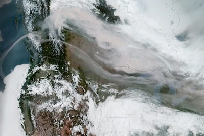
Satellite view Saturday of dense smoke from fires in
Alberta pouring across the International Border into
Montana and surrounding states
 San Francisco and Seattle have reputations for clean air. Breezes off the Pacific Ocean usually sweep air pollution away and people breathe easy.  

Calgary, Alberta, Canada is also known as a clean air city. It's on the high plains just east of the Canadian Rockies, not far from Banff National Park.  

In recent years, though, those cities have had relatively brief but disconcerting episodes in which they had the worst air pollution in the world. Worse than Beijing. Worse than New Delhi. Worse than than Lahore. 

The problem is wildfires. Thanks in large part to climate change, these cities have had episodes of intense, dangerous air pollution. 

The latest victim is Calgary. The smoke from Alberta wildfires is spreading far and wide But Calgary, a major city closest to the fires, is really socked in by the smoke. 

Smoke this past week in the Canadian city was downright dangerous, even for healthy people. The smoke was double the level considered hazardous, and visibility was done to a half mile. Calgary was probably the most polluted city in the world on Tuesday. 

This is reminiscent of San Francisco in 2021, when wildfires turned the sky and air an apocalyptic orange, and created serious health alerts. 

For a time last October, Seattle had the worst air quality in the world due to wildfire smoke. Some wild fire smoke has returned to Seattle from Canada in recent days, but it's so far not as bad as last year. 

Back in Canada, the wildfire smoke problem has been getting much worse in and around Calgary. They rarely had problems with smoke before about 2015, but since then, it's been a yearly issue. 

The smoke isn't just annoying and disheartening. It's dangerous. The smoke can endanger people with lung and heart problems, and worsen asthma. 

The American Lung Association says wildfire smoke contains tiny particles that can embed themselves deep in the lungs, which is why it's so dangerous. The smoke can trigger heart attacks and strokes in susceptible people. So it's nothing to be trifled with. 

Wildfire smoke from Alberta, Canada blotting out the
sun over Vermont on May 8 

The worst spring wildfire season in Alberta continues to grind on in the face of record early season heat. Smoke from these fires have spread far and wide.  Record high temperatures continued across western Canada this week, encouraging fires to spread and new ones to start.

Even up in the Northwest Territories of Canada, where snow should still be on the ground, wildfires are burning amid the record heat. 

At least 90 fires were burning across Alberta as of this week, so the smoke isn't going to stop anytime soon. 

Air quality alerts were in effect yesterday and continue today in Montana, Washington State, Minnesota and other states as the smoke was at ground level there. 

The smoke is even more widespread aloft, streaming over much of the United States. I once again noticed smoke high overhead in Vermont this morning. That's at least the eighth day this month in which smoke dimmed the sun over the Green Mountain State. 

So far, anyway, the smoke over Vermont hasn't really made it to the surface, although a bit haze in the air this morning and on some other days in the past couple of weeks indicates a few of those particulates in the wildfire smoke is making it into our lungs. 

Still, air quality in Vermont hasn't been too bad. The air quality index in Vermont was still in the "good" range this morning, so no issues there. 

Thursday, May 18, 2023

Vermont May Freeze Is One For The Record Books, Crop, Garden Damage Assessments Begin

UPDATE 5 PM THURSDAY
Frosted and half wilted plants in my St. Albans, Vermont
gardens this morning. Record cold throughout the state.

Some remarkably cold temperature reports continued to stream in today from this morning's record cold temperatures.

I saw an unconfirmed report of 14 degrees in Enosburg Falls, though another warmer part of that town, which is huge in area, reported 21 degrees.

North Troy, Vermont got down to a stunning 17 degrees. Lyndonville reported 20 degrees. Waitsfield and South Lincoln came in at 21 degrees.

Even southern Vermont got into the frigid act. It was 22 degrees in Bethel. West Rutland reported 25 degrees. 

I was lucky in St. Albans in which my pretty big gardens only suffered light damage here and there. It's about 90 to 95 percent intact. Phew!

Many other places aren't so lucky.  I didn't get a chance to travel far and wide today, but I did see some noticeable garden damage when I ventured into Williston, Vermont, which reported 25 degrees. 

As is typical in these freeze situations, lower valleys tended to fare worse, while hillsides were a bit warmer and places near Lake Champlain were fine. Killington reported a not-bad 30 degrees. Near Lake Champlain, South Hero bottomed out any 35, while Burton Island State Park had a balmy low of 38 degrees.  

The fact that I live up on a St. Albans hillside is probably what saved my gardens. 
This was a magnolia bloom in Williston, Vermont 
before last night's freeze decimated it 

There's still a chance of frost early next week, but the forecast continues to indicate that one won't be nearly as cold or as widespread as the one we just endured. 

PREVIOUS DISCUSSION

The intense cold wave for this time of year is a big record breaker, as all kinds of new temperature marks were set yesterday and this morning. There was even a new snow record! 

Let's start by going through a preliminary list of records. Do note that as of early this morning, I might not have captured the coldest readings, as not all the reports were in as of 7 a.m. But here goes:

Burlington managed to experience its snowiest May 17 on record Wednesday. True, only a handful of snowflakes drifted down. But this is the first May 17 in data going back to the 1880s on which is snowed on this date.

It wasn't the latest snow flurry on record, though. On May 31, 1945, snow briefly mixed with a cold rain  on a notable cold day. 

Burlington's high temperature Wednesday of 48 degrees ties the record for the coldest high temperature for May 17.  Montpelier only made it to a high of 43 degrees on Wednesday, its chilliest high temperature for the date. 

Before midnight, Saranac Lake, New York was already down to 21 degrees, setting a record low of 21 degrees. That notorious Adirondacks cold spot eventually got down to 16 degrees this morning, which is whopping and also of course a record. And, it was 17 degrees there for at least three consecutive hours!

Burlington got to at least 29 degrees, cold enough to tie the record low for the date set in 1983. Montpelier got down to 24 degrees, smashing the record low for the date by three degrees.  

Crabapple blooms in Williston, Vermont  showing 
damage from this morning's freeze.

Across Vermont, temperatures were shockingly low for May 18.  The coldest I've seen so far are 19 degrees in Island Pond a Gallup Mills, both up in the Northeast Kingdom. It was 22 degrees in Morrisville and 23 in Lebanon, New Hampshire, so I assume White River Junction was just as cold.

The chill extend through southern Vermont. Bennington and Springfield both reached 26 degrees. 

DAMAGE

It's too soon to say how much damage this cold wave caused. As I write this at 7 a.m., it was still below freezing in most places, so any harm isn't really apparent yet. I'm sure orchardists and others will be assessing their plants and crops during the day today. 

Lake Champlain did its job and held temperatures to 32 degrees or a little higher in most of the Champlain Islands, which is great. 

I noticed Plattsburgh, with a little hint of a breeze off the water, stayed above freezing until 6 a.m., when it briefly touched 32 degrees there. 

Frost on garden plants this morning, St. Albans, Vermont.

The freeze is of course disheartening to gardeners and nature lovers, but many plants have a remarkable capacity to recover. This will all be forgotten by June at the latest.  

A potentially depressing sight among many will be the coldest areas of Vermont where leaves had appeared on trees. You'll see patches of brown or wilted leaves in forested areas for awhile until trees can sprout new growth. 

Most Vermont forests can withstand temperatures down to the mid-20s for brief periods, so if you stayed at, say, 26 degrees, most if not all of your trees should stay green.  Flowers on those trees might turn brown, though. 

Lilacs are in full bloom in many areas. Those bushes are tough old birds, so I've got my fingers crossed the blossoms will do OK, except where it got especially cold. My lilacs, so far, look OK, but I'll have to take another look once it warms up. At that point any harm will become apparent. 

RECORD LOWS NOW RARE 

As we well know, cold snaps, even record cold, is still very possible in the age of global warming.  It's just now, the dice are loaded. Roll the weather dice these days and you're more likely to hit a record high. But every once in awhile, that roll of the dice will give you a real chill, like today. 

A frosty leaf in a St. Albans,
Vermont garden this morning. 

Burlington's data really shows that. Checking back this morning, I discovered that before today, the last time the city broke or tied a record low was on November 11, 2019. 

In the time since frigid November day in 2019, Burlington tied or broke 29 daily record highs. Two of those - in May, 2020 and November, 2022 -  were hottest ever for those entire months. 

CLIMATE CHANGE INFLUENCE

I hate to blame climate change on every instance of weird weather. Still, this cold wave could possibly, maybe have some relation to climate change. 

An enormous "heat dome" a massive area of warm high pressure has set up over western Canada and the northwestern United States.  Heat records are being shattered in western Canada because of this. 

This heat dome has steered the jet stream way north into northwestern Canada and the Arctic northeast of Alaska. The huge northward excursion of the jet stream set up a corresponding major dip in the jet stream that roared southeastward from the Arctic toward Quebec and New England. 

This arrangement grabbed some frigid air from the still-frozen Arctic and slammed it down on us. At least briefly. Some scientists suspect these huge heat ridges, and corresponding dips in the jet stream, have become more likely with climate change. 

The newly erratic jet stream, if verified by scientists, would mean that overall, we're warming up, which helps explains what was until now a rather warm spring in Vermont. But that snaking jet stream can create nasty cold spells that briefly interrupt the overall warming trend. t 

Of course, there are consequences to this. Everything bloomed early this spring, making plants, trees, crops and gardens all the more susceptible to a late frost. 

This big ridge ridge of high pressure out west will plop another cold snap on us early next week, but that one won't be quite as bad as the one we experienced yesterday, overnight and this morning. Still, there's a very real risk of frost and local freezes in at least some parts of the state, probably Monday night. 

After that, a change in the weather pattern will flatten that western ridge and help push warmer air into our neck of the wood, This new pattern would also block any other bowling balls of cold air to smash their way south into New England to further ruin our spring