Saturday, August 31, 2024

More Vermont Summer Flood Updates As Recovery Continues

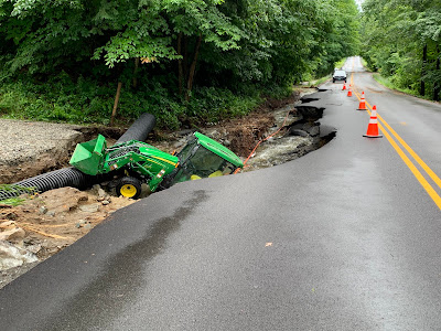
Floodwater beginning to recede in Hinesburg, Vermont
on July 11 after causing a lot of damage. Recovery from
the summer floods continues, with a variety of updates
coming in as we move on from the disasters. 
 Now that we're leaving our hot, humid, awful flood-wracked Vermont summer, there's always a few updates to the stories of the disasters, so here's just a few. 

Lyndonville Bridge

The Sanborn Covered Bridge will return to its perch over the Passumpsic River in Lyndonville after all.

The bridge had been removed from its spot over the river for restoration. There was never any question of whether the bridge would be restored. But would it need to give up its function as a river crossing?

The Lyndon area and the Passumpsic River have flooded with increasing frequency and severity in recent years, thanks in large part to climate change. People in the region are looking for ways to mitigate these floods.

The Sanborn covered bridge and its abutments are a pinch point in the Passumpsic River, possibly worsening floods upstream. So the question was whether the bridge should go back up where it has been so long. 

As WCAX reports, after feedback from Lyndon residents, the bridge will be placed back over the river this fall. However, adjustments will be made to its abutments to allow water to pass through more easily. 

Tourism Steady

Despite the international headlines regarding Vermont's floods this summer, the all-important tourism traffic  to Vermont seemed to be steady, WCAX also reports. Their article didn't have much in the way of numbers, revenue and that kind of thing. Mostly, I believe because it's too soon to tally things like sales tax and rooms and meals tax revenue for the summer. 

Bookings for the fall foliage tourism season in Vermont seem to be running a little ahead of last year, too. 

Still, as reported earlier this summer, not everyone is doing well after the flooding. Nearly 350 Vermont businesses have already reported flood damage.  And businesses in some of the hardest hit communities like Lyndonville, East Burke, Plainfield and Barre are still struggling. 

Snowmobile Trails In Rough Shape

Vermont has about 5,000 miles of snowmobile trails, and those are an important part of the state's winter tourism. As WPTZ reports, so far, there's at least $1 million in damage to the trails and that damage is scattered over wide areas. 

Getting things fixed in time for winter will be complicated. As WPTZ says:

"The trails that span near 5,000 miles across the state are split between locally owned land, state land and private property, which makes it harder to qualify for flood help."

Still, the Vermont Association of Snow Travelers, which maintains the trails, say volunteers are helping fix the damage and the trails should largely be in good shape this winter. 

If it snows for a change.  

Humidity, Rain Contribute To Late Schools

Some schools in Vermont have delayed openings this fall because of hazardous mold. The problem is a combination of outdated HVAC systems and an especially humid summer that contributed to moisture in school buildings, and resulting mold. 

By some meteorologists' estimates, this has been the most humid summer on record in Vermont. All that lingering moisture has created mold issues in schools like Otter Valley High School, Milton Elementary, and Moretown Elementary. 

Moretown Elementary was damaged by flooding last December. 

"We are seeing a lot of flooding, a lot of rain, a lot of moisture and similar to our roads and infrastructure, our schools are not ready, they're not prepared for these kinds of changes," Sen. Brian Campion, the chair of the Vermont Senate Education Committee told WPTZ. 

Some FEMA Aid Delayed

The Federal Emergency Management Agency is once again out of cash, and that will delay some assistance to Vermont towns and cities that suffered damage this summer, Vermont Public reports. 

Individual homeowners and renters in seven Vermont counties can still get funds from FEMA.  More than 500 people have applied.

But as Vermont Public tells us, FEMA is technically out of cash, so they can't pay local and state governments to fix roads, bridges and other infrastructure. 

That money should come through eventually, but Congress has to pass a budget first. Good luck with that, as the U.S. Senate and especially House can't seem to get anything done these days.  

Friday, August 30, 2024

Two Extreme And Dramatic Weather Events Prove Fatal In Alaska, Arizona

Extreme flash flooding in the Havasu Creek and Falls
area of the Grand Canyon last week killed one person
and forced helicopter rescues for dozens of others. 
 I've been a bit fascinated and horrified in the past week of two big local weather-related events in two very different, scenic spots. One was a landslide in Ketchikan, Alaska and the other an epic flash flood in northern Arizona. 

I often cite local disasters like this as evidence of the harm created by climate change. 

Both of these disasters might have been related to climate change, but I don't know for sure and can't prove it either way. But still, they're pretty intense. 

NORTHERN ARIZONA

Havasu Creek and Havasu Canyon in northern Arizona - part of the Grand Canyon are an incredibly scenic spot in northern Arizona, popular with hikers and vacationers. It features Havasu Falls, a gorgeous blue-green feature that attracts thousands of tourists annually and is a main attraction to the Grand Canyon 

Hundreds of hikers were in the canyon and along the creek last Thursday when disaster struck. It's monsoon season in Arizona, when moisture from both the Pacific Ocean and the Gulf of Mexico find their way to the Desert Southwest. 

The monsoons create intense thunderstorms, famous for creating abrupt flash floods in the deserts, low water crossings, creeks, canyons and back country of Arizona. 

Last Thursday, an especially intense monsoon struck in and around Havasu Canyon.  The resulting flash flood was epic, stranding at least 100 hikers and sweeping away a woman, who was later found dead. 

Reports News 12 in Arizona:

"Chenoa Nickerson, 33, was hiking with her husband near Havasu Creek on Thursday when the  couple was swept away by the flash flood. Her husband was able to be rescued by rafters, but Nickerson went missing in the Colorado River."

Her body was eventually found 20 miles downriver. Nickerson's family is raising money for the National Park Service Search and Rescue in her honor. Family members said the search and rescue team is historically underfunded, and they believe this is a great way to honor Nickerson's memory. 

I couldn't agree more. 

The death toll could well have been higher, but Havasupai tribal members who live in the area recognized the flash flood situation developing and warned hikers to seek high ground immediately.  

The Havasupai Tribe's reservation is perhaps the most remote in the nation. You can only get to it on foot, mule or via helicopter. 

Havasu Falls and surrounding trails are now off limits to visitors for the foreseeable future. The tribe is working with FEMA on coordinating repairs.  Although monsoon flash flooding is common in this area, the one that struck last week was much worse than usual.  

Dramatic video of the flash flood are here and here. 

KETCHIKAN, ALASKA

Ketchikan, Alaska, on the state's panhandle south of Juneau,  is normally very wet - one of the wettest cities on Earth. Its normal annual rainfall is about 150 inches. (That compares to roughly 40 inches a year here in Vermont).  

Aerial view of the big landslide
in Ketchikan, Alaska.

Recently, however, the tain was too much even for soggy Ketchikan. A tragic landslide last Sunday buried part of a city neighborhood, killing one person and injuring three others. Numerous homes were destroyed in a dense neighborhood not far from downtown, reports Alaska Public Media.

The person killed was Sean Griffin, a senior maintenance technician for Ketchikan who was off duty but volunteering to clear clogged storm drains when the landslide hit. 

A number of factors could have contributed to the slide. Around 2.5 inches of rain fell on Ketchikan that day That's unusually heavy for a single day there, but not record-breaking.  

 Fatal landslides have been increasing in southeast Alaska, with four such slides in the past decade. It's possible climate change has had a hand in this, as increases in temperature, precipitation and wind associated with climate change might be making the steep landscape less stable. 

Gabriel Woken of the Alaska Division of Geological and Geophysical Surveys said he suspect climate change might be playing a role, but the causes of the landslides are so complex that it's hard to know for sure.  

Planning Your Labor Day Vermont Weekend: Rain To Sun, Summer To Autumn

Vermont's Labor Day weekend will bring a variety of 
weather, but we're hoping skies on Monday will
look like they did here in St. Albans yesterday
Note the hints of fall color in the trees. It's
possible a little wildfire smoke might make the sky
not quite as blue as this Monday, but then again,
the smoke could miss us.    Rain on Saturday, though.
 UPDATE 6 PM FRIDAY

Forecasters have backed off a little with the rain on Saturday. You might be able to get some outdoor stuff done in the morning, as rain could well hold off a bit, according to late Friday afternoon forecasts.

So far, no other major changes to the weekend forecast

PREVIOUS DISCUSSION

The Labor Day weekend is upon us, the last unofficial weekend of summer. I hope you get a chance to enjoy some time off.  

Weather always factors into the planning, of course. 

So, overall here's the idea:

Saturday: Plan on doing something indoors, especially afternoon/evening.

Sunday: The beach day, with a big asterisk

Monday: Take a hike. Or do something outdoors. 

Here are the details:

Yesterday, we unofficially declared summer in Vermont over. As if to emphasize the point, a strong cold front will take us from a brief squirt of humid weather later Saturday and Sunday to a classic autumn, crisp day on Labor Day itself. 

If you're getting an early start to the weekend, today looks fine. We should see quite a bit of sun, and it will be a little warmer than yesterday.  The warmest valleys could touch 80. It'll be kind of breezy, especially in the Champlain Valley as south winds are picking up

The main surge of wet air will come well ahead of the cold front. Saturday looks to be very nearly a washout, with high chances of rain all day. You'll also notice it getting more and more humid as the day passes. 

Most of us will a half inch to an inch of rain, which all of our rivers and streams should be able to handle just fine. The only danger is there could be isolated instances in which heavy showers form in a line that hits the same spot repeatedly.  If that were to happen, we'd see - once again - so very local trouble with water. 

I'm not too worried, though.  If that happens, it'll be pretty isolated, and not extreme like some of the storms we saw over the summer.

For Sunday, I said above it's the beach day, but you will need to be ready to scramble. We'll have a partly sunny, breezy, somewhat humid day as temperatures climb to near 80 once again.  That's why it will at least start off as a nice beach day. 

But that cold front will be approaching with at least a broken line of showers and thunderstorms that will come through mid to late afternoon, the National Weather Service office in South Burlington tells us. 

So, if you hear thunder or see dark clouds coming, grab your beach stuff and rush over to the car.  The thunderstorms probably won't be severe, though some might be strong with gusty winds. Enough to cause a few broken branches and a couple power outages in the very worst cases. Nothing widespread, though. 

Monday will be that crisp autumn day we talked about. Perfect for a hike to the summit of  Camels Hump, or an excursion to an apple orchard, or a boat ride on the lake. 

Highs will only reach the 60s, and there should be a steady northwest breeze. Temperatures should fall back pretty quickly toward sunset, so bring a hoodie.

I'm hoping we see the type of bright, blue clear skies we saw during that refreshing burst of Canadian air we saw yesterday. 

However, there are some pretty big fires burning in central Canada. It's possible the rush of cool air from Canada on Monday will grab some of the smoke and bring it our way. 

If it does, we might be denied the bluebird blue skies, and it could turn out hazy on Monday. Dunno yet. But if some smoke does come our way, it will be mostly high overhead, so air quality down here where we live should be OK. 

Thursday, August 29, 2024

I'm Now Declaring That Vermont Summer Is Over

Altocumulus clouds cover the sky over St. Albans, 
Vermont last evening. I tend to associate these clouds
with autumn, which is in keeping with my 
thinking that summer is over. 
OK, I've decided, summer is over. 

My ruling is the most subjective of them all, but it's plain our hot, wet, humid summer is behind us.  

That's not to say we won't have any more warm or even hot weather. Or humid spells. We probably will. But the season has turned. 

This feeling that summer is over almost always used to hit in mid to late August. In recent years, it seems like we have to wait until early or even mid-September for the bulk of summer to be over.  

And it's still possible we could have a long stretch of mid-summer like weather as the calendar turns to September. 

But the weather lately has checked all the boxes for calling an end to summer. 

There are so many signs. One is the spots of fall color you see here and there in the otherwise still green landscape of Vermont. That's typical of late August, but there does seem to be a bit more of that color than I usually see this time of year. That could just be my imagination or impression, who knows.

Even the warm spells have an autumn feel. 

Tuesday evening a brief surge of warm, humid air was making its way into Vermont. In full summer, it doesn't take much to bring such weather into the Green Mountain State, so spells of muggy weather don't have much wind when they arrive at our doorstep in, say, July.

But Tuesday evening, as I sat in my outdoor tub enjoying the cool water, I watched the trees sway in a gusty south winds. It's starting to take more force to drive toasty air into Vermont. 

Cold fronts have lately been bringing cooler and cooler air to the Green Mountain State. The opening salvo was those three days that never got out of the 60s for highs last week. It got down to 51 degrees in Burlington this morning. That's not particularly chilly for this time of year, but it was still the coolest morning since June 28.

The forecast has more cool weather on our agenda.  After a brief squirt of somewhat higher humidity Saturday and parts of Sunday, Labor Day promises to be a classic crisp Vermont autumn day with sunshine and highs only reaching the 60s. 

Even the type of cloud cover we're seeing lately screams autumn. Last evening, we had a beautiful display of altocumulus clouds, which look like a series of small cotton balls covering the sky.  I associate this type of cloud with autumn, because it seems I see them most frequently in September or October.

The sounds outdoors have changed, too. I'm hearing far fewer songbirds and plenty more crickets, which is a classic autumn song list, if you will. 

Of course, there are more scientific and less subjective definitions of autumn than my own "feelings" about it. 

Astronomical autumn begins at 8:43 a.m. EDT on September 22. 

Meteorological autumn, which is an easy way for climatologists and others to assess a season's weather, starts September 1 and lasts through November 30.

Summer, at least measured in Burlington, Vermont, looks like it will be among the top five warmest. We were headed toward warmest summer on record, but the last ten days or so of cooler weather looks like it will keep 2020 in the top spot.

And, if Burlington gets at least 0.58 inches of rain during the expected showers on Saturday, it will become the city's tenth wettest summer on record. 

Long range forecasts suggest we'll have a warm, and possibly wet autumn here in Vermont. Long range forecasts aren't always accurate, but those hot predictions ahead of this summer proved accurate. And autumns have definitely trended warmer in recent years across Vermont. 

Seven of the top 10 warmest autumns in Burlington have happened since 2011. So, though summer might be over in my opinion, bouts of summer-like weather still seems to be on the horizon for awhile yet.  

Wednesday, August 28, 2024

Vermont Summer: At Least The Pumpkins Are Big

Vermont Agriculture Secretary Anson Tebbetts snapped
this photo of this year's giant pumpkin contest at the 
Champlain Valley Fair.  The winner, middle pumpkin
weighed a record 1,327.5 pounds. 
I had a post the other day, I inventoried some of the negative effects such a hot, humid, wet summer we had on Vermont.  

But there were plusses to that oppressive weather, too.

Like giant pumpkins.

Wilbur Horton of Springfield, Vermont entered a giant pumpkin at the Champlain Valley Fair this past week that shattered the record for the heaviest one on record there. His pumpkin weighed a staggering, 1,327.5 pounds, as WPTZ reports. 

The old record for the most giant pumpkin any the fair was set last year, another hot, wet summer. That 2023 pumpkin weighed a mere 1,280 pounds. 

Most of the credit for this year's giant pumpkin record has to go to Horton's pumpkin growing prowess. He is, after all, a member of the Vermont Giant Pumpkin Growers Association. (I had no idea such an organization exists, but it sounds fun).

Still, pumpkins love hot, humid weather so the conditions were ripe, so to speak, for Horton's gourd. Southeastern Vermont, where Horton lives, was not as wet and somewhat sunnier than northern sections of the state during the summer, so that surely helped. 

If you want to see the winning pumpkin for yourself, there's still time. It's on display in the fairgrounds in Essex Junction until September 1.

Certain other crops do well in a Vermont summer that was more like you'd see in the Mid-Atlantic States.  My garden is producing cucumbers so prolifically and fast that my husband finds himself frantically pickling them so they last longer. 

I understand there's bumper crops of tomatoes. I see apple trees are sagging under the weight of a huge number of fruit. Also, don't get me started on zucchini.  

If you have a bumper crop, or giant pumpkins or other huge veggies, let me know. 

Tuesday, August 27, 2024

Still A Lull In Atlantic Hurricanes, But Pacific Busy, Hawaii On Guard

Hone passing south of Hawaii's Big Island over the weekend.
 An odd lull in tropical storm and hurricane activity continues for now in the Atlantic Ocean, with no signs of a new tropical storm forming for the next few days. 

The Pacific Ocean side of things has gotten busy, though. And that includes a menace to Hawaii.

Tropical Storm Hone (pronounced "ho-NEH") increased to hurricane intensity with top winds of 80 mph as it passed south of the Big Island of Hawaii early Sunday.  

The storm brought tropical storm force winds to parts of the Big Island, along with more than half a foot of rain on slopes that faced the east winds created by Hone. 

Flash flooding was reported in some areas, but overall damage wasn't too bad. A landslide blocked a highway.  High winds blew the roof off at least one home.

Hone weakened somewhat back down to a tropical storm once it got past Hawaii.

Meanwhile, Hurricane Gilma, once a powerful Category 4 hurricane is moving westward in the general direction of Hawaii. It should be somewhere near Hawaiian Islands by the end of the week. But by then, forecasters said, Gilma will have weakened to a swirl of relatively weak winds and showers. 

ATLANTIC

The expected super busy Atlantic hurricane season went into a big stall over the past week with fortunately no activity.  This was a bit unexpected as we approach the peak of what should be hurricane season.  

A welcome sight over the past weeks. No forecasted
tropical storms in the Atlantic from the National Hurricane
Center. This image was on their page Tuesday morning. 

This time of year, disturbances often move off the west coast of Africa into the Atlantic Ocean, where some of them turn into tropical storms or hurricanes. 

 Some meteorologists are saying that in the past couple weeks, the disturbances are moving off the African coast further north than usual.

That puts the disturbances in cooler, drier air than they'd be in had they been further south. The cool, dry air tends to suppress development. 

Ocean temperatures are really warm out there, which is great for developing hurricanes. But the upper atmosphere far above the ocean is also oddly warm.  You need a contrast between a hot ocean and a cold upper atmosphere to create the thunderstorms that eventually turn into hurricanes. 

The lack of a contrast now seems to be helping prevent those thunderstorms from developing.

That said, signs point to tropical activity finally, unfortunately ramping up, perhaps as early as this weekend.  Disturbances coming off the African coast look like they might start drifting further south into the warm, humid air they need to develop.

Other factors also seem to be coming together in the tropical Atlantic to produce storms. So things might get busy after all. By Wednesday, the National Hurricane Center began watching two areas of interest. One stormy area, not far from Bermuda, isn't expected to amount to much. But another system in the middle of the tropical Atlantic. 

That said, there's still no guarantee that new tropical storms will form in the coming week or two. And if they do, it's far, far, far too early to know where they might form and where they'd go.  

Vermont (Mostly) Dodges Another Storm Bullet As Big Hailers Strike New England/New York

You gotta watch those thunderstorms that come in straight from the north. 

A thunderstorm near Sheldon, Vermont earlier this summer.
Severe storms and lots of hail hit parts of 
central and southern New England Monday but
the region is nearing the end of its summer
severe storm season. 
Often the weather systems that cause storms to move north to south can create more havoc than the traditional west to east moving thunderstorms we often see in the summer. 

Given the cold air aloft, Monday's storms were impressive hailers, covering the ground with tons of quarter sized or bigger stones in several communities in central and southern New England, and in parts of the southern Adirondacks and upper Hudson Valley of New York. 

Some of this hail was big enough, and powerful enough to probably keep insurance adjusters busy the rest of the week. 

We in Vermont largely sat out this icy storminess, though far southern Vermont had some moments. Parts of southeastern Vermont was under a flash flood warning for a time. Video on social media showed lots of half inch diameter hail,  pouring down on a property near Readsboro, Vermont. 

Half inch diameter hail was also reported at Woodford State Park, east of Bennington. 

Elsewhere, things did get out of hand. Video from somewhere in Essex County, New York - that's the large county in the southeastern Adirondacks on the other side of Lake Champlain from Addison County Vermont - showed inches of hail covering the ground with obvious damage to plants, and reports of damage to cars and trees blown down by wind. 

Another social media photo showed so much hail on a road in Hancock, New Hampshire (east of Keene) that it could have used a snow plow. 

The storms extended all the way down to Bourne, Massachusetts on Cape Cod which was hit by large hail and flooding. 

Northern Vermont entirely escaped the storms. Some scattered storms rolled southward along and east of the Green Mountains during the day but nothing severe hit up there. The Champlain Valley actually had a lovely day.

Before dawn, though, isolated storms dumped up to two inches of rain over the Lake Champlain Islands, and caused briefly strong winds in Georgia. 

LOOKING AHEAD

Things are much calmer today as that weather system has departed.  We'll have one more sunny, warm summer day today before the next cold front sweeps through late tonight and tomorrow morning. 

Nothing scary with this next front except for maybe brief heavy downpours in spot. 

Cooler, drier weather follows. These increasingly cool gushes of air as we approach September is a sign that  Vermont and New England's rough summer severe thunderstorm season is beginning to wind down. 

We can still see severe thunderstorms for the next few weeks, of course. But as we head into autumn, it gets harder and harder to see the very warm to hot, humid air that can be fuel for strong thunderstorms. 

As the cold fronts come in, you're going to be less and less likely to see strong thunderstorms ahead of them and more likely to see just a period of rain instead. 

Given the flooding we had in Vermont, and the severe storms and tornadoes that repeatedly raked New York and New England this summer, it really is probably good riddance to those intense summer storms. 

Monday, August 26, 2024

Strong, Unusual Storm Outbreak Likely In Midwest Today, Some Severe Risk New England, Too

An outbreak of very intense severe storms is likely
in the Upper Midwest today. New England has a much
lesser, but still real chance of some severe
storms today, too.
 Severe storm forecasters today are worried about an unusually strong outbreaks of severe storms in parts of the Midwest, which include the risk of a derecho, or possibly two of them affecting the same general area.  

New England and to an extent Vermont is under the gun for severe weather, too, but not nearly to the extent as what's going on in the Upper Midwest. More on New England in a  bit. 

Today's target area for intense storms seems to be much of South Dakota, the southern half of Minnesota and western Wisconsin. 

NOAA's Storm Prediction Center is pretty aggressive with their wording regarding the hazards in that neck of the woods. They're expecting supercell thunderstorms to develop in South Dakota, then merge into a bow  echo plowing into Minnesota.

A bow echo is a line of often severe thunderstorms, arranged to form what looks like a backwards letter"C."  In this case, the supercells and the line of storms are expected to spin off tornadoes. possibly many hurricane-force straight line wind gusts and giant hail.

If this lasts long enough, it would be considered a derecho. A derecho is defined as a line or cluster of severe storms that have a path of at least 240 miles long, with frequent reports of winds at or exceeding 58 mph. 

The most destructive thunderstorm in U.S. history was an August, 2020 derecho, mostly in Iowa that caused ??? in damage

Today, after that initial line of storms in South Dakota and Minnesota, the Storm Prediction Center expects another batch of supercells to form in South Dakota. These would again merge and rake many of the same areas that would have had the expected earlier storms with more hurricane force gusts.

There's always a lot of uncertainty with severe weather forecasts, so this likely won't develop exactly as I outlined here. But if you live in the area I outlined, or know somebody who does, they should stay weather aware all day today and well into tonight so they're ready to take cover from what could be some very scary storms. 

These storms are hitting an area beset yesterday and today with extreme humidity, which is fueling the expected storms.  The dew point, a measure of how humid it is, reached an incredible 81 degrees in Yankton, South Dakota Sunday.

Any dew point over 70 degrees is considered oppressive. Although the actual temperature was only 92 in Yankton Sunday, the heat index was 111 degrees.

NEW ENGLAND

A southward moving disturbance promises to set off scattered storms today, some of which might be severe. Southern New England has the highest risk of damaging winds and large hail in scattered storms. 

These southward moving disturbance can set off surprises. An initial ripple in the atmosphere touched off some rather isolated, but slow-moving storms over the Lake Champlain islands overnight. Parts of Grand Isle County, Vermont had more than two inches of rain from these. Meanwhile, not that far away in St. Albans, I received a meager 0.15 inches. In Burlington, no measurable rain fell. 

Today's storms, including the risk of a strong one, could hit anywhere, but are most likely east of Lake Champlain, and probably south of Route 2. Already this morning a few downpours formed in central Vermont and had begun working their way towards the southeast.

That doesn't mean areas in the Adirondacks or close to the Canadian border are off hook.  Some scattered downpours developed in the Adirondacks a little before noon, and I wouldn't be surpise

A few more shower and storms might develop further north later, then move southeast. We'll wait and see on that. 

The chances that storms will grow big enough to produce local instances of damaging winds and hail are definitely greater in southern New England than here in Vermont. Still, we might see isolated instances of trouble over the afternoon in the Green Mountain State.

Things should simmer down by the time sunset rolls around this evening. 

Humid, Wet Summer In Vermont Caused Garden Woes, And Mosquito, Lake Dangers

Despite frequent applications of Neem oil and copper fungicide, 
the hot, humid summer encourage pests which took an
unusual toll on this rose mallow plant in St. Albans, Vermont.
Funguses, pests and other ills are diminishing backyard gardens.  Algae blooms have occasionally made parts of Lake Champlain unsafe.  Mosquito-borne dangers like West Nile disease loom. 

Blame all this on one of Vermont's hottest, wettest and definitely the most humid summer on record. Our northern ecosystem isn't used to this weirdly tropical weather. 

By at least one measure, Vermont had its most humid summer on record. At least since the 1940x, anyway. According to meteorologists at WPTZ-TV:

"Burlington has....recorded its most humid summer on record (through Aug. 19, going back to 1948.  There have been over 220 hours (almost 10 full days) of oppressive humidity so far this summer. 'Oppressive' refers to dew points of 70 degrees or higher."

The previous record was 200 hours in 1994.

All this has had its effects. I told you the other day that the type of summer we had will probably contribute to extra bouts of fog this autumn. 

But there are worse issues going around than fog. 

Water in Lake Champlain reached record high temperature of around 80 degrees in early to mid August. Meanwhile, this summer's floods discharged mud, pollution, phosphorus and other yucks into Lake Champlain, hindering water quality goals, as VTDigger points out. 

These flood discharges, working in concert with warm lake water temperatures, contribute to cyanobacteria, a blue-green algae that looks like thick pea soup or a paint spill, according to at least one lake biologist.

While much of this algae is relatively harmless, if incredibly yucky, some of it can turn toxic, making people ill who swim in it. It's also known to kill dogs who venture into it.  Satellite images revealed a large outbreak of this algae across the northern end of Lake Champlain in early August. 

Mosquitoes have had a field day this summer, what with all the rain we've had, and the humidity, and the heat. Illnesses such as West Nile and eastern equine encephalitis, or EEE have been detected in Vermont mosquitoes this summer.

This type of thing happens almost every summer, but this year's weather has made the problem all the more likely. 

West Nile has been detected in at least one mosquito pool up in Alburgh, and EEE has been found in mosquitoes in northwestern Vermont. 

Home gardeners like me have seen issues in shrubs and in both perennial and vegetable gardens. Fungus, powdery mildew and an influx of insects have dimmed the glory of many gardens, or have at least frustrated gardeners.

Finally, the hot, wet summer could have an effect on this fall's foliage season.  It's too soon to tell, but sometimes, the fungi that frustrate gardens can infiltrate leaves in our forests. While these fungi ultimately don't hurt the trees, they can make leaves turn a dull brown and fall off prematurely. Which is a bummer if you're hoping for a brilliant foliage season.  

Sunday, August 25, 2024

Vermont Weather Week Ahead: Normal Weather For A Change!

Pretty much normal weather coming up in Vermont 
this week, but there's always a few surprises. As dawn
broke, a few unexpected dark clouds, and in a
few spots, a couple surprise showers this morning.
For a big change, I'm not going to talk scary weather in Vermont.

There's no big heat wave coming in.  Not much in the way of humidity to talk about, either. There's no gigantic flood risk. It's not going to be cold, either,  No tornadoes, no locusts, not much in the way of weirdness, either. 

For once we have a sort of normal weather week coming to Vermont. Normal  for this time of year means highs in the 70s to around 80 and lows in the 50s to around 60. It also means the ever-present risk of showers here and there. 

We're going to be close to that "normal" game plan all week.  But this being the Green Mountain State, expect plenty of day to day changes and some surprises here and there. 

The first surprise is this morning. There were a few showers scattered around as of 7 a.m., which I didn't expect. 

As of that hour, most of them were in eastern New York, heading into the southern half of Vermont.  They didn't look especially heavy, and I imagine they will clear out later this morning. A few other showers lurked in northern New York, so a couple places in the upper half of Vermont could get briefly wet, too. We'll see. 

Those showers did appear to be weakening somewhat, but that might not be the end of it. 

FOR STARTERS, AN UPPER LOW

After those unexpected scattered light showers clear out this morning, it should be a mostly nice day.  Some sun, highs getting close to 80, humidity reasonable. 

But I can't say there's no further rain risk. The latest in a series of upper level low pressure systems is starting to dive down from eastern Canada.

As previously advertised, this one is weaker and warmer and faster moving than the system that caused the chilly, dreary weather this past week. Still, it'll bring us some weather. Again, nothing extreme.

A few more isolated showers or even a rumble of thunder could pop up this afternoon, with the best chances the closer you get to the Canadian border. 

Again, we could see an afternoon surprise or two. Up until now, most forecasts had limited the risk of showers and storms to the far north and kept them very few and far between.

Some computer models just released this morning suggest more scattered storms, not just isolated ones. They'd still be hit and miss, but instead of just affecting areas north of Route 2, a few could pop up just about anywhere.  

If you have outdoor plans today, you might need to move inside for a little while to avoid lightning and quick downpours. That doesn't apply to everyone, just some unlucky towns here and there. 

Monday

On Monday, as the upper low dives southward and over New England, plenty of showers and thunderstorms will develop as this thing destabilizes the atmosphere. 

A couple storms could be strong-ish, and there's a marginal chance that one or two will create some damaging wind gusts during the afternoon. So, if you're very unlucky, you might briefly lose power, and lose a couple tree branches, too.

It won't be humid enough to cause super torrential downpours, and the storms will be moving too fast anyway to drop all that much rain. So for once, Vermont will not see any flooding. Or flooding risks. Hallelujah!

Tuesday:

A classic late summer day as the upper low gets out of the way. We'll have a fair amount of sunshine, and it will feel rather humid again.  Again,  nothing extreme.  

Later Week

Long range forecasts from a few days ago had strongly hinted at some possible late season heat to close out the month of August. Meteorologists have backed way off on those projections, now that we have better data. 

Instead, strong high pressure in eastern Canada looks like it will shove another cold front southward across Vermont around Wednesday. That'll bring some showers, and some cooler air. 

Once again, by cool, I mean air that might only be a couple degrees below average for this time of year. Nothing out of the ordinary for the end of August. 

It's possible - but not definite - that we might get a quick squirt of hot, humid air toward next weekend. But new cold fronts also lurk then, too.  

This being Vermont, I'm sure some unexpected things will come up during the week. Like they always do. But it is nice that the weather is actually "boring" for a change. 


Saturday, August 24, 2024

Fog Season In Vermont Has Arrived And This Year Could Be A Doozy

Sunflower stalks on a foggy morning late last
fall in St. Albans. Vermont 
 Every year, in the final days of summer and the first half of autumn, dense morning fog is a frequent visitor in Vermont.  

The nights begin to get a little cooler. Meanwhile, lakes, ponds, rivers, even the soil is near its peak temperature of the year. 

These bodies of water, and the soil, and the leaves on the trees, emit moisture. When the temperature drops overnight, that moisture condenses into fog. It clings to the river valleys and can cut visibility to near zero until it burns off by mid morning. At least usually. 

The season has started already, as it often does in August. Patchy dense fog was scattered around Vermont early this Saturday morning. 

This autumn could well be an especially foggy one.  It was a much warmer than normal summer, last week notwithstanding, so water and soil temperatures are higher than they usually are. 

The increased contrast between the cooling nights and the warm water and soil is a recipe for fog.

Satellite view this morning shows fog in river 
valleys, especially the lower White and Connecticut
River valleys. 

You surely noticed this summer was also really, really wet. Soils moistures are high, so that adds a lot of water to the atmosphere. The more moisture available in the air, the more likely you're going to have fog.

Even in nights when humidity is low, the moisture coming from the ground, the rivers, the lakes, the leaves on the trees can really add plenty of ingredients for fog.

From now into October, any night that is at least sort of clear and calm will give us a bunch of fog. 

The morning fog in the autumn can be spectacularly beautiful. When foliage season hits, I always recommend people get an early start. The photographs of the fall foliage emerging into sunshine from the fog can be incredibly gorgeous. 


Of course, the autumn fogs can be dangerous. You're blasting down the road in clear air, and all of a sudden you punch into a fog bank. 

Visibility goes to zero, and you don't even see the car braking ahead of you, until it's too late. And yes, the fog can be dense enough so that you don't see the brake lights.  

Over the next few weeks, the sun is still strong enough that the fog will surely burn off by mid morning. The sun heats the air, the contrast between the cool air and the warm ground disappears, so blue sky and sunshine quickly re-appear by 10 a.m or so.

Dense fog cuts visibility to near zero on a 
St. Albans, Vermont street last year. 

Later in the autumn, the sun angle is lower, so the heat is not as strong. Especially this year, I imagine, we'll end up with several days that on paper should start out foggy then turn sunny. Instead, those days sometimes turn out to be entirely gloomy. The fog lingers, then maybe lifts into a low, gray overcast. The mountain tops end up in the sun, but us valley dwellers experience a dreary day. 

On some of those days, the sky finally clears late in the afternoon, only to fog up again that night. 

Fog can be beautiful, giving our surroundings a mysterious air. But much like in the winter, plan on leaving a few minutes early for work on calm mornings. Patches of fog will mean you'll need to drive more slowly. 

Friday, August 23, 2024

National Weather Pattern Continuing With Extremes, Just Not Here In Vermont

Forecast map for today depicting patches of light
but rare August snow in the Sierra Nevada mountains
of California tonight or Saturday morning. 
 After our big August cool spell, it's back to summer, as forecast, with very seasonable, average temperatures for this time of year lasting for the next several days. 

Not so in other parts of the nation. especially out west, where weather has gotten pretty extreme, one way or another. 

Texas - especially West Texas and the Panhandle, have just gone through one of their biggest heat waves on record. 

That part of the nation gets hot, but this was ridiculous. 

Abilene. Texas reached 113 degrees this week, its all time hottest temperature on record. Several cities set new marks for the entire month of August, including 112 at Del Rio, 111 at San Angelo and Carrizo Springs, 109 in Sonora and 108 at Kingsville and Amarillo.

Meanwhile, that cold, out of season storm sliding southward along the Pacific Coast still looks like it will bring rare August high elevation snow to the Sierra Nevada range.  Some places above 7.900 feet above sea level in the high mountains might see their first August snow in two decades. 

In eastern Washington, blowing dust advisories were in effect Friday and Friday evening. Outflow from expected strong storms was expected to stir up dust from rangeland and recently plowed fields, resulting in the risk of zero visibility at times on some highways. 

Both new fire starts and flash flooding are possible in the mountains of California with this weird, cold system.  A flood watch is up for north central California, as downpours triggered by the storm could cause debris flows where there have been recent fires. 

As far as new and worsening fires go, at looks like Nevada is most under the gun today, with the risk spreading into Wyoming Saturday. 

This chilly weather system on the West Coast is forecast to be short-lived, with a return to hot, dry weather next week. 

Lyndon Area Might See More Historic Changes Due To Floods: Does A Historic Covered Bridge Need To Be Removed

The Sanborn covered bridge in Lyndon. You can see how
it was pinching the flow of the Passumpsic River
beneath it. The bridge has since been removed from its
position for restoration. Due to increased flooding the
bridge might cause in the future, it's been recommended
the bridge not be placed back over the river 
after restoration is complete. 
 One of the many problem with big climate-related disasters is we know they can easily happen again.

Part of the dread is such disasters mean we face more big adjustments.  

You're going to have to change your life, your community, and what is familiar. It might be little things, it could be biggies. 

There's going to be hard decisions, and there's no straight answers on which solution is the right one. 

Which leads us to the Sanborn covered bridge in Lyndon.

It's one of several such historic spans in and around Lyndon and Lyndonville, up in the Northeast Kingdom. 

Before the flooding this summer and last, the Sanborn covered bridge was already slated for a temporary removal and a restoration. it would be moved off to the side, totally renovated and restored, then put back on its perch over the Passumpsic River in Lyndon.  

A community park would be constructed adjacent to it.

The work has already started, and the bridge is off to the side of the river, with work starting on it. But will it eventually go back to its spot spanning the river? Suddenly, we don't know. 

Lyndon, reeling from two catastrophic floods this summer, is looking for ways to mitigate future disasters. It turns out one problem is the Sanborn covered bridge. Or at least its location spanning the Passumpsic River.  

The bridge and its abutments constricts the river, helping back it up into a nearby mobile home park.

Removing the bridge would help. As VTDigger reports:

"At the manufactured home park just upstream, the bridge removal would reduce floodwaters by 0.3 feed during a 10-year flood and 0.6 feet during a 500-year flood, projections show."

A half a foot might not sound like much, but that could be the difference between water entering a home or just passing almost harmlessly beneath it. Or it could be the difference between minor damage and the loss of most of a resident's belongings. 

 The mobile home park has been partially or fully evacuated numerous times in the past few decades. Homes there were badly damaged in this July's flooding. 

I think it would actually be better to move the manufactured home neighborhood out of harm's way, since more flooding is inevitable. Especially in this age of climate change. But where would all these people go?  Who would pay for the move? Certainly not the residents, most of whom are probably living paycheck, to paycheck in the best of times. 

VTDigger describes how this is all painful, controversial and uncertain:

"Figuring out a path forward on the covered bridge project will be a challenging and important endeavor," Selectboard Chair Chris Thompson said during the board's Aug. 5 meeting.

'We need to try to get a win-win out of this,' he said."

The covered bridge won't go away.  The town will restore and keep it one way or another. But whether it spans the river like it was designed to do is now an uncertain. It will likely be one more departure from the familiar, from the way it's always been.  

For those who might ask what the big deal is about an old bridge, these covered bridges are a centerpiece of the state's history, and are absolutely treasured across the Green Mountain State.

We're gradually losing them to floods and other disasters, so we want to preserve them as much as possible.   Tropical Storm Irene back in 2011 destroyed the 1870 Bartonsville Covered Bridge in southeastern Vermont, local residents cobbled together federal aid, insurance payouts and lots of local donations to restore it. 

That restored Bartonsville bridge is now handling traffic again, just like it always did. 

Back in Lyndon, the hope is there will be a similar happy ending. Maybe things will be different, but still beautiful and historic. 

The Sanborn covered bridge dilemma is just one example of how Vermont towns and villages - and communities all over the world - have to make difficult decisions and see sometimes painful changes in the the fabric of these communities. 

A covered bridge isn't the only issue facing the region. 

Already in Lyndon and Lyndonville, the iconic Miss Lyndonville Diner shut down in the wake of July flooding. A new owner might buy it and revive it, but we don't know that as fact yet. Village Sports, also in Lyndonville announced earlier this summer it would need to stop a ski and snowboard program for area youths because its stock of snowboards was destroyed in this summer's floods. 

There's a long list of other important for Lyndon and Lyndonville to consider after the floods. How best to repair roads and bridges?  To what extent will federal money help? 

Should the town and homeowners take advantage of a buyout program, in which owners of flood-vulnerable homes sell them, and they they are demolished and turned into open land so that nobody else has to live through a flood on that site. How badly will such buyouts wreck the tax base?

These are questions being asked in towns all across Vermont. The answers will be slow in coming, I'm sure. I also bet there will be some wrong answers, not intentionally wrong, but just what you get when  you make educated guesses. 

Every time it starts to rain, it seems the main question that runs through everybody's mind is, "What fresh hell will this bring?" Almost always, the answer is none. We know that the vast majority of rain storms are harmless.

 But the PTSD of epic storms in the recent past mean you never know when it'll hit again, and what painful questions the next one will bring. 


Thursday, August 22, 2024

Drones In New York City Warn Of Dangerous Weather

A drone (if you look carefully
at middle of photo) delivers
a flash flood warning to
a New York City
neighborhood on August 6.
 Out in the Midwest and other areas, tornado sirens blare when a twister threatens.

On your smart phone, you get an obnoxious, but potentially life saving loud noise when a warning for dangerous weather pops up.  The National Weather Service and your friendly local meteorologists post similar warnings online and on TV when the weather gets too risky.  

But drones?

When flash flooding threatened New York City on August 6, the city deployed high tech drones to fly over vulnerable neighborhoods warning of the impending danger. 

For good reason. New York has tons of flood-prone basement apartments, some legal, many others not so much.

In 2021, the remnants of Hurricane Ida swept into the New York City metro area, unleashing record amounts of rain and creating intense flash floods. 

Eleven people died when they became trapped in New York City basement apartments as they filled with water from Ida's torrents. Many others barely escaped with their lives, but lost all their possessions

The Big Apple probably has something like 100,000 people living in illegal basement apartments, according to estimates.

Many of the people living in these apartments might not have easy access to flood warnings. Hence the drones. 

The drones flew over vulnerable neighborhoods, broadcasting flash flood warnings in English and Spanish.

Or sort of Spanish. 

The drones' voice translation of Spanish from English left a lot to be desired. Apparently, the Spanish coming from the drones was awful, so bad hardly anyone could understand it. 

Roughly a quarter of NYC residents speak Spanish at home, so it's important to communicate warnings in that language. 

The Spanish warning sounded like a robot trying to say the words phonetically, but pronouncing them like a rube who has never in his life heard a Spanish word before. It sounded bad to me, and I have next to no ability to say anything in Spanish. 

As it turned out, the text of the message as written in Spanish was correct. The recording was muddled, though, city emergency officials said. 

The English language versions were pretty straightforward, anyway. The drones, buzzing over neighborhoods, said, "If you live in a basement or a ground floor apartment, leave your location if flooding occurs."

The intentions of this drone were good,  but reaction on social media was not great. "Creepy," "Scary," "Very Orwellian," "Cringe" "Yikes" and "Shoot it" were some of the responses.

To me, yeah, the drones seemed a little weird. But I can support any method available to warm people of life-threatening danger. 

In the end, there was some flash flooding in New York that day. Central Park was deluged with two inches of rain in just a few hours on August 6. Thankfully, the downpours were not nearly on the scale of what happened during ex-hurricane Ida. 

During Ida, Central Park received 8.2 inches of rain, including 3.15 inches in a single hour. As you can imagine, the flooding then was extreme.  

But this kind of thing happened again. The catastrophic flooding Sunday in Connecticut caused by six to 12 inches of rain was painfully close to New York City.  So these drones might not be the worst idea after all. 


Upper Level Cold Low Beginning To Depart, To Be Replaced By Weaker, Warmer One

Wednesday was as gloomy a Vermont summer day as you can get, as expected.

That pesky upper level low we've been talking about was right over us, ensuring the raw, wet weather continued all day.

You can see in the radar loop I've posted. 

Hard to see but focus on about St Albans in northwestern Vermont. You see all those numerous showers rotating around that point. 

Rainfall was pretty heavy in some spots, with waves of showers peaking during the early morning Wednesday, mid to late afternoon and again after midnight last night. 

It looks like Burlington got about two-thirds of an inch of rain out of this system, in addition to the three quarters of an inch that fell Monday.

Rainfall was really impressive here in St. Albans. My unofficial rain gauge collected 2.4 inches of rain.  The breakdown of that is the one inch of rain with the cold front Monday, then another 1.4 inches from Tuesday morning to this morning. 

Other spots reported very little rain. Montpelier had a half inch of rain with Monday's cold front, and about a tenth of an inch Tuesday and Wednesday,  It was hit and miss, as usual. 

There were a smattering of reports of ponding of water on some roads and minor flooding. A Facebook group showed a photo of water flowing across Leary Road in Jericho where it meets up with Nashville Road, for instance. 

All of Vermont rivers are far below flood stage and will cause absolutely no problems today. But they are still running pretty high for August. 

The thick clouds at night kept temperatures from crashing too much during this cool spell. Lows have been in the 50s, just a few degrees below average.

The clear skies southwest of this cold pool created record lows in the central Appalachians. There were even pockets of frost in the cold hollows of West Virginia Wednesday morning. Parkersburg, West Virginia reached 45 degrees, beat the record low for the date by six degrees.

Even though skies will be clearing over Vermont tonight, the atmosphere is warming, so it will only be kinda cool. Lows in the 48 to 55 degree range for most of us. 

Satellite view of the upper level low over northern
New England at around 6 p.m. Wednesday.  You
can also see a wisp of wildfire smoke wrapping 
around the outer edge of the system, extending
from Virginia and North Carolina to just off
the coast of Cape Cod, Massachusetts. 

The good news is this thing is now slowly on its way out. Today will be not great, but definitely better than yesterday. And Friday looks gorgeous.  

Some showers will still harass us today, but they won't be as numerous as they were on Wednesday, And we might even see some sun before the day ends. Especially in southern and western Vermont. 

It's back to summer tomorrow after our pre-autumn spell. It won't be THAT warm, but it'll be well into the 70s with quite a bit of sunshine. 

Going forward, the weekend and early next week look OK, but not perfectly sunny. We're still in a weird pattern that favors these cut off lows - pools of cool air in the upper atmosphere that are shunted away from the jet stream, so they don't move much.

It seems like another cut off low, one that will be far weaker and much warmer than the one that is currently departing, will make itself felt by Sunday night or Monday.

That just means we face another round of scattered showers during that period. Since this cut off low won't be bringing in a batch of cold Canadian air, temperatures will remain near normal for late Auset. That means highs in the 75 to 82 degree range and lows within a couple degrees of 60.


Wednesday, August 21, 2024

It's Official: Part Of Vermont Declared Federal Disaster Area From July Flood

Flood damage near Hinesburg, Vermont on July 11.
Chittenden County, where Hinesburg is located, is
one of seven Vermont counties declared a federal
disaster area due to mid-July flooding. 
 President Biden on Tuesday declared seven Vermont counties a major disaster area from the epic flooding we experienced in mid-July. 

The declaration covers damage caused by flash flooding on July 9-11, mostly in central and northeastern Vermont. 

Says the Associated Press:

"The declaration makes federal funding available to people in Addison, Caledonia, Chittenden, Essex, Lamoille, Orleans and Washington counties, federal officials said. It also includes funding to help communities in those counties repair flood-damaged roads and bridges."

It designation doesn't cover the catastrophic flooding in the Northeast Kingdom back on July 30. Vermont Gov. Phil Scott has made a separate disaster declaration request for that event. 

Scott has also asked for a separate disaster declaration from the U.S. Department of Agriculture to deal with farmers suffering severe damage in much of central and northern Vermont.   

Orange County was also left out of this federal disaster declaration. The Scott administration is working to add that county to the seven others singled out for the help. 

Here's what the disaster declaration does:

People living in the seven counties under the disaster declaration can apply to the Federal Emergency Management Agency's individual assistance program.  his helps with reimbursement for flood recovery expenses that insurance doesn't cover. So things like home repairs or home replacement and rental assistance. 

The declaration also means that FEMA could provide up to 75 reimbursement for towns, cities and villages that had to make emergency repairs to roads, bridges and such immediately after the flood. 

To apply for assistance, register at FEMA's disaster assistance website. Or you can call them at 1-800-621-3362.


A Summer Of Upper Level Lows Creates Strange Weather, We Are Experiencing The Latest Now

Upper level forecast map from NOAA for this
evening. One upper low spinning over northern
New England, and another northwest of Washington
State heading southward toward northern California.
 This is ending up being the summer of odd upper level cut-off low pressure systems that are all promoting strange, and sometimes dangerous weather here and elsewhere in the nation. 

An upper level cut off low is a storm in the upper levels of the atmosphere that's separated - or cut off- from the jet stream. 

Since the jet stream isn't there to push them along, these upper level lows - which are really pools of cool air aloft - tend to meander and move slowly. That, in turn, causes sometimes extended periods of unsettled, bad, or even dangerous weather. 

The latest of these upper lows is over us now.  I wouldn't say what we're experiencing this time is especially dangerous, though it does have its hazards.

Our current upper low is over-performing, as so many weather systems have lately. It's stronger and more persistent than many previous forecasts indicated. It's producing more rain than prior predictions hinted at too.  It's pretty damn chilly under this thing, too. 

Some places around Vermont will have near record low high temperatures today. Burlington missed that record by just two degrees Tuesday, as it only reached a high of 62 degrees. Burlington won't break that record today.  The lowest high temperature on this date was 58 degrees in 1982.  It was already 58 degrees as of 

I had said for the past several days that the rain with this system would fall far short of creating any flood risks. 

It turns out that it actually might cause issues, but the risk is pretty low. The upper low is pretty much right over us, which means any showers that get going today will move very slowly. 

This afternoon, the contrast between the meager (and I do mean meager) warmth near the surface and the very cold air aloft will give the showers a convective feel. Instead of the bland gray overcast with light rain we had this morning, things will evolve into tall billowing clouds which could produce local downpours. 

NOAA's Weather Prediction Center has actually put us under a marginal risk of excessive rains or local flash floods today. 

I still don't think this will end up being a major issue, though. There might be local, minor problems, but as you've surely noticed, we're lacking the deep tropical humidity that can lead to torrential downpours. So we're not going to have flood havoc today. 

Satellite view of a cut-off low centered over central
New England on the evening of July 29. This 
system would go on to cause a devastating flood
in the Northeast Kingdom of Vermont
several hours after this pic was taken. 

But since scattered afternoon downpours might have such a slow forward motion, we'll have local issues with ponding of water on roads, and minor washouts here and there, especially where recently repaired roads and driveways haven't been packed down and stabilized yet after prior flood damage. 

OTHER CUT OFF LOWS

Other upper level cut off lows have caused strangeness, and worse, scary danger here and elsewhere this summer. 

It was a meandering upper level low that tapped into deep tropical moisture that unleashed horrendous downpours on the Northeast Kingdom back on July 30.  We all know the calamity that caused. Don't worry, nothing like that will happen today in Vermont. This is a completely different situation. 

A more recent upper level low (related to the one we're dealing with now) contributed to dangerous flooding in and near Toronto last Saturday and deadly flooding in Connecticut on Sunday. 

Yet another cut off low is heading southward along the Pacific Northwest coast. It promises to briefly interrupt a very hot, dry summer in California and probably will lead to a very rare summer snowfall up high in the Sierra Nevada mountains. Snow levels could go as low as 7,600 feet above sea level.

Strong, dry winds ahead of this system are likely to stir up California, Nevada and Oregon forest fires today, making them especially dangerous. 

I'm not sure whether these upper lows are related to climate change or not.  Likely not. But the torrential rains associated with some of them probably are. As the atmosphere warms, it can hold more moisture. Meaning that when you get "perfect" setups, like July 30 over the Northeast Kingdom, it means the downpours end up being heavier than they would have been decades ago. Meaning bigger disasters. 

As for our that upper level cut off low meandering overhead in Vermont today, it will get a push to move slowly to the northeast and out of our hair by Thursday night. By Friday and the weekend, we should be back to our regularly scheduled, late summer warm but not hot weather. 

Tuesday, August 20, 2024

Vermont Forecast Keeps Getting A Colder And Colder Look

Dark, cool and dreary for August this morning in St. 
Albans, Vermont. It's going to be like October
probably through Thursday. 
 The cool spell that arrived in Vermont is now looking like it might well be one of the chilliest spells of August weather we've had in years. 

It won't be the coolest August weather on record, not by a long shot. As I wrote the other day, we used to regularly have autumn-like episodes of weather in August on a regular basis. 

Still, this will probably be the nippiest August regime since at least 2014.  That was the last time we had three consecutive days in Burlington in which high temperatures never made it out of the 60s. 

Even then, those three days in August, 2014 were in general about as cool, or even possibly slightly warmer than what's in the forecast for today through Thursday.  

Originally, today was supposed to the coolest day of the bunch. And it will be chilly by August standards with highs only in the 60s.  

But we should see glimpses of sun every once in awhile between the clouds, and there won't be all that many showers around. So you'll actually get to go outside and, I don't know, enjoy the isolated pockets of fall foliage that have already popped up?

Wednesday now looks to be the more shockingly chilly day of this.  At least shockingly compared to what we've seen most of the time this summer. 

The cold upper level low pressure causing this brisk weather will be right on top of us.  That will inspire lots of clouds, and numerous showers, though they will be light showers. 

But it will be a nasty day for late season summer visitors to Vermont. I hope they brought more than t-shirts and shorts. High temperatures will range from the mid-50s - that's it - over somewhat higher terrain of the north, to the mid-60s in banana belt towns in the Champlain Valley and lowlands of southeast and southwest Vermont. 

The forecast high of 63 in Burlington is normal for October 6.  We still probably won't have the coldest high on record for the date. That honor goes to August 21, 1982, when the "high" in Burlington reached a less-than-balmy 58 degrees. That was the day I mentioned previously in which people were skiing three inches of snow atop Killington. 

Speaking of snow, I do wonder if Mount Washington. The forecast high up there Wednesday is just 40 degrees, with lows in the mid-30s.  That might be cold enough for a few wet snowflakes atop New England's highest peak. 

It won't get cold enough for snow on the higher summits of Vermont's Green Mountains. Still, hikers should take note that summit temperatures will only be within a few degrees either side of 50 today through Thursday.  Rain showers will make it seem colder. A cotton t-shirt and sandals won't cut it, folks! 

The cool, showery weather is now forecast to continue well into Thursday, which is a change from forecasts issued a few days ago. Those earlier forecasts had said a warmup would start then, but now the warmer weather is postponed until Friday, and won't really kick into gear until the weekend. 

By Saturday and Sunday, we should see daytime highs poke into the low 80s for many of us. That's about normal, or a little warmer than average for this time of year. 

Until now, this August has been running decidedly on the warm side. But this cool spell might take the month down to the cool side of what is the new climate change normal for the month. It all depends on how balmy it gets - and stays - after this cold snap departs. 

I'm making a big deal out of a spell of autumn in August, only because by today's standards, it's odd. But like I said earlier in this post, and in a post I put up on Sunday, this kind of thing used to happen all the time in mid and late August. 

It's all just another way we've adjusted to a new normal in the age of climate change.