Showing posts with label weird. Show all posts

Friday, March 28, 2025

Friday Evening Vermont Storm Update: Awful Wintry Mess Tonight, Saturday. Pretty Bad Sunday, Too. And Monday Weirdness

Still looking at a good thump of snow in northern Vermont,
mostly overnight and Saturday. This snow forecast map
updated Friday afternoon.
We're gearing up for our big weekend storm and here is a very quick Friday evening update.

The forecast remarkably hasn't changed too much since this morning. Note that meteorologist still think there could be big changes in the forecast if the position of a nearly stalled weather front shifts unexpectedly. 

There are a few forecast updates as of Friday afternoon.  

Here they are:

The winter weather advisory has been upgraded to a winter storm warning for  most of the Northeast Kingdom, north central Vermont and parts the western slopes of the Green Mountains.  

There, five to nine inches of snow is expected, mostly late tonight and Saturday morning. The heaviest snow north will probably come down from a little before midnight tonight to mid morning Saturday. 

Lighter precipitation is likely in the afternoon. . Some sleet and freezing rain is also likely Saturday night and Sunday. 

Elsewhere in Vermont, the winter weather advisory is still in effect. 

In general, it looks like the forecast has maintained expected snow amounts in northern Vermont north Route 2.  It might have cut back the totals by maybe an inch or so in the far northern Champlain Valley, but that's just background noise.   

However, forecasts for the amount of freezing rain have ominously remained the same, mostly in central Vermont. There, meteorologists are thinking many areas could still see at least a quarter inch of ice accumulation, which is another to begin bridging down tree branches and power lines. 

Ice accumulation forecast map updated Friday 
afternoon still looks ominous for central Vermont.
Red zones could have problems with power outages
and tree damage. 
A few places could see a half inch of ice, which would really cause a lot of trouble. Luckily,  knock on wood, the half inch amounts so far at least don't look that widespread. 

It also still looks like a number of areas will still be dealing with freezing rain for the first half of Sunday before temperatures start to rise later in the day. Even where the rain isn't freezing, it will be a cold raw days.

Monday and Tuesday will be shocks to the system.

It looks like rain might taper off for a number of hours Monday and the sun might come out a little. That could bring temperatures up into the 60s for many of us, which is just ridiculously different than Saturday and Sunday will be.

As the cold front approaches later Monday, I wouldn't be surprised if there were a few rumbles of thunder. 

Rapid snow melt and rain later in the day could lead to some flooding issues. But we still don't have updates on that, and so far it doesn't look like the flooding will be serious. Knock on wood. 

By late Monday night, it'll be in the 20s, with highs only in the 30s Tuesday. 

It's one of those springs in Vermont, folks!

Friday, March 21, 2025

In Dystopian Climate World Of Trump, A New Word In The Lexicon: "Greenhushing"

It seems everybody's afraid of the Trump administration. 

Or they don't want to deal with Trump's fragile ego. 

This trembling in your boots mindset has spread to corporations. Some just co-opt themselves, abandoning any values they had to please Dear Leader. 

They ditch their supposed DEI policies, write statements espousing the alleged sheer brilliance of Trump, and disavow an attempts to fight climate change, legitimate or note. 

Other companies retain their values for the most part, but feel they have to hide it.  

Which brings us to a brand new term: "Greenhushing."

That's when a company hides or under-reports information about its environmental policies and actions. In some cases, they do that to avoid accusations of the more familiar term "greenwashing."

Greenwashing is when companies exaggerate how wonderful they are for the environment. Greenwashing is all a bunch of PR. The products aren't as environmentally friendly as advertised. The company's purported activism on combating climate change is false.

Greenhushing, meanwhile, has gotten new attention as corporations try to avoid the Wrath of Trump. 

If Trump finds out that a company is doing something to combat climate change, he'll just launch a flurry of mean tweets against them or worse.  The mean tweets are really just his rants on Truth Social, which is his social media platform. 

If you love reading Trump's rants and those of his sycophants, Truth Social is the site for you!!!! 

Anyway, greenhushing appears to be the way to go. Not just in the United States, but elsewhere, for various reasons. Per Bloomberg:

"Along with the fear of political blowback, worries about reputational damage and regulatory scrutiny weigh on companies especially outside the U.S.  In Europe, where tackling climate change is still on governments' agendas, researchers say companies are pulling away from publicizing their climate efforts due to the risk of being seen as greenwashers."

Greenhushing is remarkably widespread: Bloomberg again: 

"In 2024, 63 out of the 100 largest publicly listed firms in Britain were under-promoting their work in environmental protection, according to an analysis by the Manchester UK-based research firm Connected Impact........When it came to U.S, companies the researchers found the desire for staying unnoticed was even greater - as many as 67 major public and private firms resorted to greenhushing"

A company has got to do what a company has got to do, though, right?  So if an outfit does things that help the environment, and help the fight against climate change, but doesn't broadcast it, there's really no harm. 

They're getting the job done of fighting climate change, so it's all good. Even if they have to keep their heads down to avoid the Wrath of Trump.  

Monday, March 17, 2025

Monday Evening Vermont Flood Update, Water Receding But Weather To Turn "Interesting" Again?

Winooski River running high and muddy late this 
afternoon near Burlington, Vermont's Intervale. 
 Today was a gloomy Gus of a day over Vermont with fog, drizzle, light rain and light sno .

Oh, and flooding. 

The flooding stayed minor, but it was widespread. Rivers were running high or in minor flood stage from the Canadian border to Massachusetts.  

In most places, the water is beginning to recede, but a lot of roads near rivers and streams are still closed by high water. 

Keep away from those roads until the water goes down and the road closure signs disappear.  There might still be some roads closed tomorrow morning, so keep that in mind as you head to work or school.

Rainfall was in line with expectations, with around an inch in southern Vermont and a third to two thirds of an inch from about Route 4 north. That amount of rain doesn't normally cause flooding. It was the massive amount of snow melt that did it under those May-like temperatures over the weekend. 

The rain kept going today because a wave of low pressure formed along the cold front that came through early today. Thankfully, the rain was light, so it had little if any effect on water levels. The rain also turned  light snow north and mountains, which effective shut off any more water runoff.

I see the hill in back of my house in St. Albans, Vermont at about 1,100 feet in elevation is now white capped again, though the snow didn't stick in my yard at about 650 feet. 

Tonight will be seasonably chilly as any light snow ends overnight and skies clear. Temperatures for virtually all of us will go below freezing, meaning the muddy morass on dirt roads might firm up a bit. 

Not for long

A NEW HEAT WAVE

It's going to get unseasonably hot again for March for a few days. 

Under sunny skies, it'll get to near 50 tomorrow, which is warmer than normal but not incredible for March. 

By Wednesday, many of us will be in the mid 60s. Those won't be record highs, mostly because of the extreme warmth of the Great March Heat Wave of 2012, which gave us a week of summer-like weather. 

Thursday also looks warm and windy, kind of like Sunday was, with temperatures in the low to mid 60s instead of the near 70 we had on Sunday .

A WINTRY SURPRISE?

The storm coming in Thursday night and Friday is looking more and more interesting. It's beginning to appear that it won't be a simple cold front that will push some rain through and then much colder temperatures. 

It's beginning to look like a strong wave of low pressure could form along the front and become a pretty impressive nor'easter. If that happens, heavy rain could turn to heavy wet snow later Thursday night and Friday. 

Too soon to know the details but we could either receive enough rain to cause new flooding, or we could see a very heavy, wet late season snowstorm, Or something between those two extremes, 

We'll have to keep an eye on this weird one closely.  Watch this space for more details as we get updates this week. 

Friday, February 28, 2025

The Vermont Weather Roller Coaster Is On An Extreme Trip

Our by now very familiar snow forecast map from the
National Weather Service office in South Burlington.
This one depicts the mostly 2 or 3 inches of snow
we expect from a snowfall tonight and Saturday
morning. More snow in the mountains as 
usual with this one. 
Around 5 a.m. this morning, it was still above freezing in most of Vermont after an overnight thaw. 

By dawn, things were quite different. 

Temperatures across the northern part of the state were crashing through the 20s, and those trends were soon to follow south. 

It's another backwards day, with high temperatures when they're supposed to be at lowest, and low temperatures in the afternoon when they're supposed to be at their highest. 

We're going to see a lot of huge temperature gyrations over the next few days. 

I'd watch it on some of the roads during this morning's commute. A few snow showers accompanied the blast of colder air this morning, so there will be a slick spot or two here and there. It might not be as widespread as Thursday's mess on the roads, but it's an issue. I noticed a pretty good snow squall in Addison and Washington counties around 6:15 a.m. today, for instance. 

Gusty winds this morning will make it feel colder, but those readings will level off in the teens and 20s this afternoon. 

Things will continue with the temperatures doing the opposite of what they should tonight and tomorrow.

THE CLIPPER

Tonight, a fast moving storm - known as one of those infamous Alberta Clippers - will come in from the west, giving us a burst of snow, then rising temperatures overnight. Maybe even a few rain showers as temperatures sneak above freezing for most of us by tomorrow morning. That will be followed by an even bigger temperature crash during Saturday afternoon.

Most of us will get a decent but short burst of snow overnight, lasting no more than six hours and depositing maybe two or three inches of snow in the valleys and up to five or six in the mountains That should hit between about 8 p.m. and 1 a.m., give or take. 

Just as the snow will last only a few hours, the "thaw" Saturday will only last about that long.  Most of us will start getting above freezing early Saturday morning, but those temperatures should start to crash by early afternoon.  Backwards again, as it normally keeps getting warmer through the early and mid afternoon. Not on Saturday!

Those falling temperatures will be accompanied by snow showers, and a few scattered snow squalls. So once again on Saturday afternoon, you could get caught on some iffy Vermont roads and highways if you're out there during the day. 

THE COLD WAVE

I know this is hitting March, when you start to expect to see  the strength of cold waves starting to wane. But this one could be among the strongest this winter. Which isn't saying a whole lot, since we never did see anything worse than 20s below this winter. 

This time we'll eventually see lows in the single numbers below zero in the warmer banana belt towns and teens below elsewhere. Those frigid temperatures should hit early Monday morning. 

Before we get there, we'll wake up Sunday morning with readings pretty close to 0 degrees. We'll only make it into the teens at best Sunday afternoon.  At least the sun will come out. 

The cold snap will be short-lived, as is usually the case with March bouts of winter weather. Monday will remain unseasonably cold with highs near 20.  But temperatures won't drop much Monday night, and most of us will be back above freezing Tuesday afternoon. 

We're still watching a storm for midweek that looks like it wants to produce rain and temperatures in the 40s.  For now anyway, forecasters have backed off on the amount of rain we'll get from it. But we'll still need to keep tabs on whether enough thawing and rain will come to set off any flooding or river ice jams.  

Tuesday, January 21, 2025

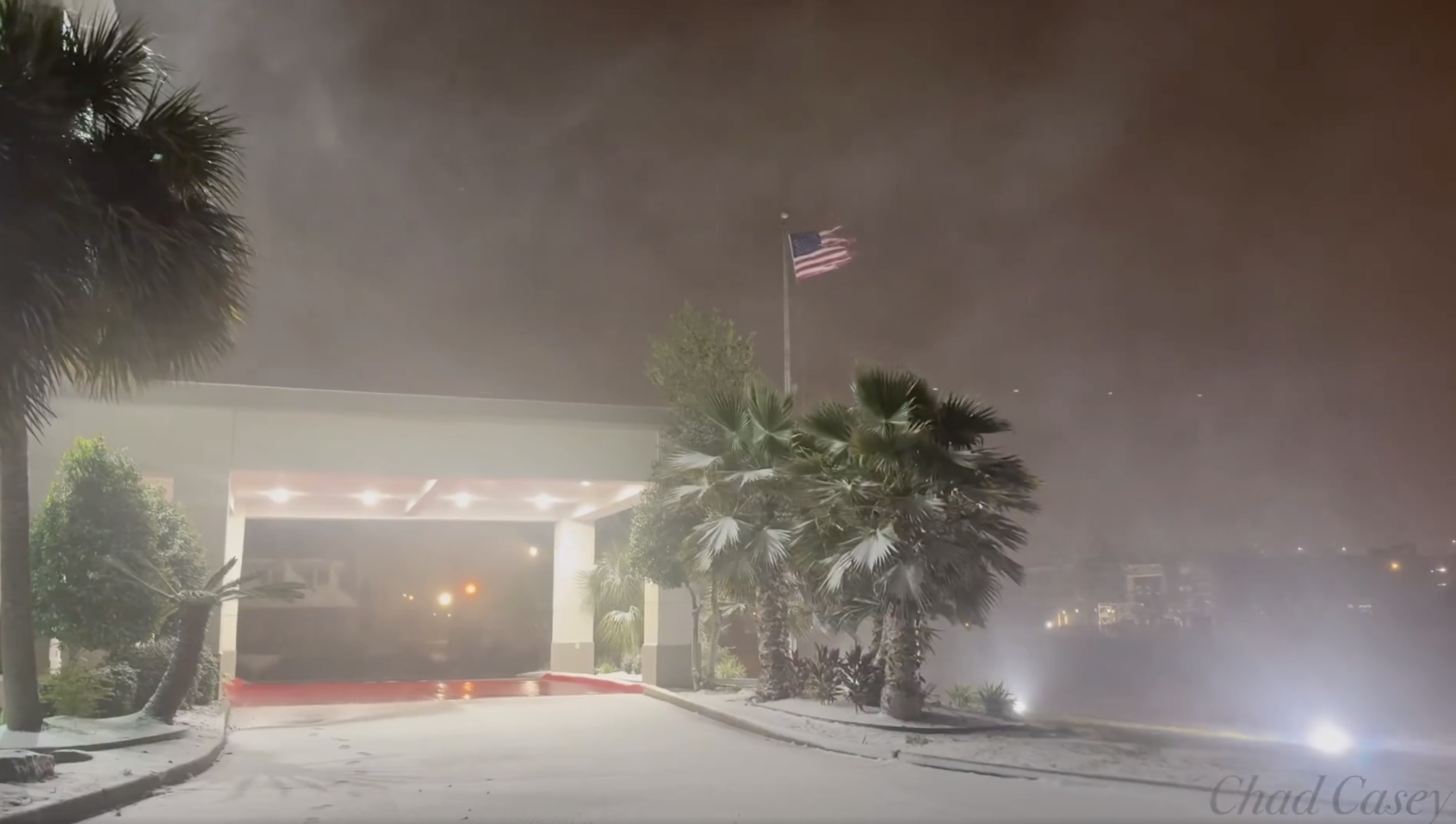
An Absolutely Bonkers Winter Storm Is Striking Gulf Coast. Blizzard Warning In Coastal Louisiana!

Screen grab of video showing strong winds, snow and
blowing snow early today in Lake Charles, Louisiana,
which is, of all things under a blizzard warning.
 The National Weather Service home page weather map had things today I don't think I've ever seen before. 

Winter storm warnings are up from far southern Texas all the way across the entire Gulf Coast to the Big Bend area of Florida. Forecasts for the winter storm intensity have gone way up since I first reported on this storm on Sunday.

A blizzard warning, of all things, is in effect right along the Gulf Coast in extreme northeastern Texas and southwestern Louisiana, including the cities of Port Arthur and Lake Charles.

I'm certainly used to seeing tropical hurricanes come ashore in this area, but a blizzard?

The criteria for a blizzard warning in the Deep South is different than for places like, say, North Dakota, but this is still impressive. 

The Louisiana blizzard zone is getting bands of heavy snow and blowing snow with gusts of at least 35 mph, so that's an impressive winter storm. Total snowfall will run the four to eight inch range in that area today.

The area under the blizzard warning normally has a high temperature in the low to mid 60s this time of year with lows in 40s. It would be like Vermont having a full-blown blizzard in mid-May. 

We'll have plenty of for-examples of how bizarre this has gotten on the Gulf Coast today. I'm already seeing a few. 

Port Isabel, Texas, a near-tropical city along the southern Texas Gulf Coast right on the border with Mexico early this morning, had arguably worse winter weather than we're currently having in Vermont. At 5 a.m. it was 36 degrees, light snow with north winds of 36 gusting to 52 mph and a wind chill of 22 degrees. 

Normally, this time of year, Port Isabel has highs in the upper 60s and lows in the mid 50s. 

A wild National Weather Service home page this morning.
All that pink you see on the Gulf Coast is
all winter storm warnings 
Five or six inches of snow is forecast for New Orleans. That would make it easily the biggest snowstorm there since eight inches fell in February, 1895. The modern record for deepest snow in New Orleans is 2.7 inches in December, 1963. 

Pensacola, on Florida's Panhandle near the Alabama border, is anticipating two to four inches of snow today, with the possibility of five inches. The biggest snowstorm on record in Florida is four inches, so we might be rewriting history here.  

Winter storm warnings in Florida extend as far south as Gainesville, where freezing rain, sleet and snow could collapse trees and power lines. 

The winter storm is expected to continue today and tomorrow on up the coastlines of Georgia, South Carolina and North Carolina

DANGEROUS

This winter storm is obviously quite the novelty, but it's extremely dangerous. 

To be Captain Obvious here, the Gulf Coast isn't built for winter storms. They're much better at handling full-fledged hurricanes than this type of weather. 

The six inches or more of snow that could fall in Louisiana could collapse roofs, since they're not built for snow loads like they are here in New England. 

The Deep South isn't used to such cold weather, either.  Pipes aren't insulated, so they'll freeze.  The epic freeze in Texas in February, 2021 caused billions of dollars in damage as frozen pipes burst, flooding homes, condos and commercial buildings. 

Snow on the ground makes frigid nights even colder. A snow-covered Deep South could end up with record temperatures in the single numbers and teens tonight or tomorrow night. 

Travel is - or will soon be - impossible in the Gulf Coast winter storm zone. It's not exactly like they have armies of snow plows and sanders to clear the roads. People there also understandably have no clue how to drive in the snow.

As of the pre-dawn hours, Houston freeways were already an icy disaster and parts of Interstate 10 in Louisiana were already closed. 

Airports are shutting down in the region, too.

The governors of Florida, Georgia, Louisiana, Mississippi and Alabama have all declared states of emergency because of this weird storm.  

The silver lining to this storm is the weather along the Gulf of Mexico should return to normal by the end of the week. Which is good, because they'll have to wait for the snow and ice to melt before anything can be done about the situation. 

Daytime temperatures should rise into the 40s by Wednesday. By Sunday, New Orleans expects a high temperature of 65, Houston should get to 68, and Pensacola is anticipating a Sunday high of 62.

Friday, December 27, 2024

Strange, Extreme Temperature Inversion To Finally Break, Then Freezing Rain, Then Rain To Mar Runup To New Year

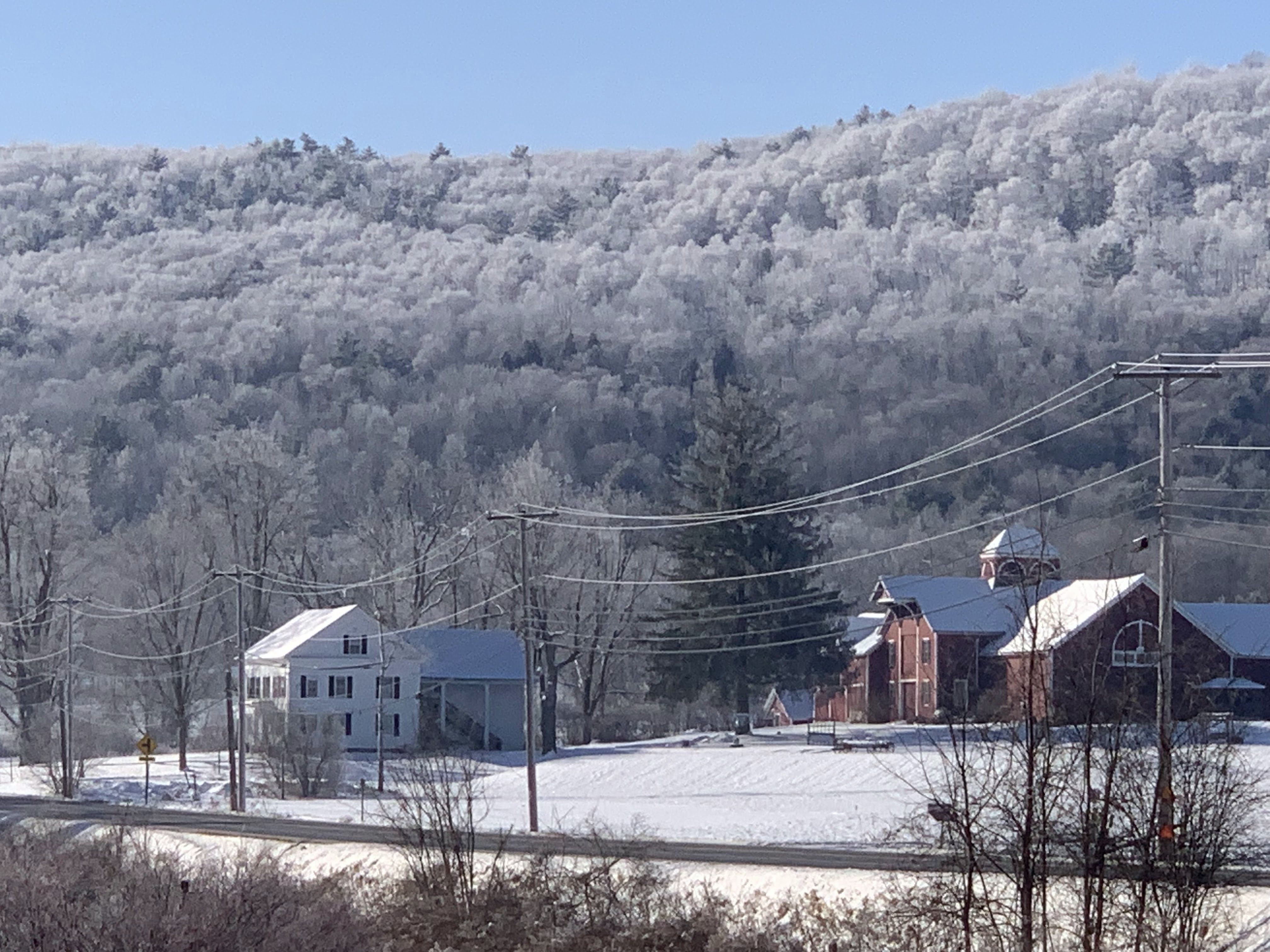
Freezing fog under an inversion broke up Thursday 
morning, leaving frosted trees glistening above an
old farmstead near Wallingford, Vermont. 
 Though it might not seem it to the casual observer, the weather has been really strange from Christmas Day to this morning in and near Vermont. 

As previously forecast, an extreme temperature inversion has taken hold.  To remind you, an inversion is when it's warmer aloft or up in the mountains than in the valleys. Usually the opposite is true. 

Inversions are more common in the winter around here, but this one is really something. 

Atop the high peaks of the Adirondacks Thursday morning, like the summit of Mount Marcy, temperatures remained in the mid 30s, even at night as temperatures in the coldest valleys got down to below zero readings. That's about as extreme a temperature inversion as I've ever seen.

The inversion has trapped the steam coming off unfrozen Lake Champlain, creating a widespread blank of low clouds and fog to spread out from the lake and cover most of western Vermont and nearby New York, both yesterday morning and this morning. 

With light north winds, I noticed the clouds were never able to break up Thursday downwind of Lake Champlain. Much of Addison County, southern Chittenden and northern Rutland counties remained socked in with clouds, even as most other areas cleared.

Where the low clouds and fog did break up in those chilly valleys, the freezing fog left behind a beautiful frost on all the trees, lit up by the low angle late December sun. It was an example of how inversions can be stunningly beautiful.

Freezing fog early Thursday left these trees in 
West Rutland, Vermont beautifully frosted over. 
This morning, temperatures in the inversion remain topsy turvy to the extreme. Under clear skies early this morning, it was 9 below at Lake Eden, Vermont and minus 7 in Morrisville. The low clouds and fog from Lake Champlain kept Burlington a little warmer at 14. 

Meanwhile, it was still in the low 30s in the high peaks of the Adirondacks. The summit of Mount Washington, New Hampshire, a place you usually find extreme cold, it was a balmy 28 degrees a little before dawn.  

Freezing fog has been an issue in spots and night, but it's been beautifying our surroundings during the day, especially where sun breaks out. The sun glistening on trees frosted over by the fog is just stunningly beautiful, so enjoy that if you see it. 

FREEZING RAIN

The inversion will gradually fade as the strong high pressure system finally exits in favor of that storminess we've been watching approach. 

Still, the inversion's fading glory will cause new problems.  That warm air aloft will continue flowing in, and will try to work its way down into the valleys. But only grudgingly.  An initial wave of precipitation is forecast to push northward into New England  Saturday while fading as it encounters dry air over Vermont and New Hampshire. 

What does arrive will start out as plain rain as it falls through the mild air a few thousand feet overhead. But it will probably freeze on impact as it lands in the cold air and cold ground down southern Vermont valleys. 

A winter weather advisory is up for the southernmost two counties of Vermont and adjacent areas of New York Saturday as that freezing rain arrives.  It won't come down hard, so there will be no issues  with trees and power lines, but there will be icy problems on the highways. 

There's some question as to  how far north Saturday's freezing rain will get, but a little dab will do ya - Even 0.01 inches of freezing rain is more than enough to make roads and sidewalks dangerous. I have a feeling those Saturday winter weather advisories might get extended at least into central Vermont.  

Not sure yet, but it's something to watch.

A more substantial surge of warmth and moisture will push northward Sunday, so we get more rain. Some valleys in eastern Vermont might not be above freezing yet even on Sunday, which opens the door for more freezing rain. 

In western Vermont, temperatures are forecast to be above freezing when the rain arrives, but that might not be much help. 

The air temperature might be in the mid and upper 30s while it's raining Sunday, but the ground will not have recovered from the cold valley temperatures we've had under this week's inversion.

 Pavement, concrete, etc. will still be below freezing, so that rain Sunday would probably freeze on roads, sidewalks and driveways. Especially if they haven't really been hit with the state and municipal salt shakers that I expect will be out. 

Eventually, it will warm up everywhere in Vermont by Monday for just plain rain. 

Thursday, October 31, 2024

Very Weird Vermont/Northeast Record Warmth Peaks Today, Part Of A Disturbing Pattern

Some previously frostbitten outdoor plants around
my house in St. Albans, Vermont are reviving amid 
record end of October warmth in the region,
 It's weird out there, folks.

We went to bed last evening, and got up this morning to temperatures more typical for mid-summer. Kind of spooky for Halloween if you ask me. 

Record shattering high temperatures are anticipated across Vermont and pretty much all of the Northeast today for sure. 

The bizarre aspect of this warm spell started yesterday. It got to 69 degrees in Burlington in the afternoon, right in line with forecasts. 

 As the sun set, the temperature should have started falling. Instead, it stayed right at 69 degrees until 9 p.m.

In fact, the temperature snuck up to 70 degrees at the odd time of 7:12 p.m. to tie Burlington's record high for the date. 

It never really cooled down overnight. As of 6 a.m. in Burlington, it was 66 degrees. That's warmer than it would normally be at that hour in July. 

Also, that 66 degrees is just five degrees below the record high for today's date. That record will be shattered.

The National Weather Service office in South Burlington is going with a forecasted record high of 79 degrees today. I suppose an 80 degree reading is not entirely out of the question. Pretty much everyone in Vermont except those up in the mountains should make it into the 70s today. Normal highs this time of year in the Green Mountain State are in the low 50s. 

Today's forecasted high in Burlington would also be easily the warmest for so late in the season.

In the past several years, we've had a really disconcerting number warmest temperatures for entire months, or of "hottest for so late in the season" temperatures in the autumn and  "hottest for so early in the year" temperatures in the spring. 

Sure, records are made to be broken, but this type of record should rarely happen. But it's been happening a lot. Climate change is helping to re-write the weather record books here in Vermont and pretty much everywhere else. 

I'm probably not going to mention them all here, but the list of earliest and latest record highs  in Burlington, Vermont is impressive:

-- 95 degrees, May 27, 2020, broke the all time record high for May by two degrees. 

-- 78 degrees, October 26, 2022, warmest for so late in the season.

-- 76 degrees, November 6, 2022, warmest temperature for the entire month of November and of course warmest for so late in the season.

-- 88 degrees April 13, 2023, hottest for so early in the season

-- 96 degrees June 1, 2023, hottest for so early in the season. Broke the previous record high for the date by a whopping six degrees.

-- 86 degrees October 4, 2023 hottest October day on record and warmest for so late in the season. 

REST OF FORECAST

This evening for the trick or treaters will be summertime balmy.  Hauling those bags of candy around neighborhoods will get the kids to work up a sweat this year. Temperatures in many locations will stay at or above 70 well into the evening. 

By the way, the previous record high for today in Burlington was 71 degrees in 2019. That was in the midst of a destructive rain and wind storm that caused a ton of damage in much of Vermont. Count ourselves lucky that we don't have to deal with any big storms this time around. 

A cold front will come through tomorrow without much rainfall. But it will continue our weather weirdness. High temperatures will probably hit near or before dawn. Those early temperatures could still be in the mid or upper 60s, which isn't too far from record highs for November 1.

Then, as the day goes on, the temperature will keep gradually falling, making it to near 50 by dark.

After that, it's back to reality as the weekend will feature near normal temperatures for early November. That means highs in the 45 to 52 degree range and lows somewhere between 25 and 35 degrees. 

We might get a brief spike of well above normal temperatures again around Tuesday or Wednesday, but it won't be nearly as summer like as today will be. 

-- 

Monday, October 21, 2024

Whack Job Conspiracy Theories Over Hurricanes Exhausting And Endangering Meteorologists

The nation's sizable tin foil hat brigade is torturing
meteorologists with whackadoodle conspiracy 
theories about hurricanes and government
weather control. People will believe anything, huh?
 The false information and conspiracy theories I wrote about the other day seemed to have spawned even more out-there wacky stories about weather control and more weird stuff.   

Social media has been rife with stories people make up out of thin air that the government, or meteorologist or somebody is creating huge hurricanes and steering them toward the United States for nefarious purposes.

Just in the past few months, it seems the madness got much worse. 

Instead of blaming meteorologists for inaccurate forecasts, it's now apparently their fault if a bad storm hits, because somehow, through dark magic or something, these meteorologists are steering hurricanes toward United States coastlines,. Or they're at least covering up for the government. 

The wackos think meteorologists are attacking us with bad weather, for gawd knows what reason. We've become a nation of idiots. 

Even a sitting U.S. House member, Marjorie Taylor Greene has joined the chorus. though I have to admit she's never been much of a reliable source. 

In any event, Greene, ever the scientist, posted the following gem on X:

"Yes they can control the weather, It's ridiculous for anyone to lie and say it can't be done."

Apparently "they" - who ever "they" are - decided to unleash a flood of epic proportions on a section of the nation that is generally more likely to vote Republican than Democrat.  Apparently evil forces somehow steered two dangerous hurricane over the Southeast to suppress the vote in red counties to boost Kamala Harris. 

I wonder if the people supposedly steering hurricanes like this are the same people responsible for the Jewish Space Lasers?

The conspiracy theories would be hilarious, ore at least eye rolling if they weren't so dangerous.

As The Guardian reports:

"Katie Nickolaou a Michigan-based meteorologist, said she and her colleagues have borne the brunt of much of these conspiracies, having received messages claiming there are category 6 hurricanes (there aren't) and even that scientists should be killed and radar equipment be demolished.

'I've never seen a storm garner so much misinformation, and we have just been putting out fires of wrong information everywhere,' Nickolaou said. 

'I have had a bunch of people saying I created and steered the hurricane, there are people assuming we control the weather.  I have had to point out that a hurricane has the energy of 10,000 nuclear bombs and we can't hope to control that. But it's taken a turn to more violent rhetoric, especially with people saying those who created Milton should be killed."

Meteorologist Matthew Cappucci, quoted in Rolling Stone, said he noticed a huge change on social media over the past few months. 

"Seemingly overnight, ideas that once would have been ridiculed as very fringe, outlandish viewpoints are suddenly becoming mainstream, and it's making my job more difficult," he said.

Alabama meteorologist James Spann, with nearly five decades of weather forecasting under his belt, said he's never seen anything like the current climate. Spann told Rolling Stone he's "inundated" with misinformation and threatening messages like "Stop lying about the government controlling the weather or else."

To be Captain Obvious here, both hurricanes Helene and Milton formed the way they did due to atmospheric and ocean water conditions favorable for such storm development.  

Those favorable conditions were not created by humans, unless you quite fairly want to include the influence of human-caused climate change. 

That human induced climate change contributed to the unusually hot water in the Gulf of Mexico, which in turn helped give the twin hurricanes a boost . 

Steering winds in the upper atmosphere steered the hurricanes toward Florida. An unusual but NOT man-made weather pattern pulled Helene up  into North Carolina.  There was no secret cabal of meteorologists steering the storm.  Mostly because humans don't have any ability to steer a hurricane. At all. 

WHY THE CONSPIRACIES?

To go deeper into the rabbit hole, we should probably figure out what conspiracy theorists think is the reason meteorologists and the government are steering hurricanes. 

The leading theory, as mentioned, seems to be forces aligned against Donald Trump are pushing the storms into areas more likely to vote for him rather than Democrat Kamala Harris. 

It is true that Trump seems likely to do better at the ballot box in northwest Florida, and western North Carolina than Harris would. 

But if I go along with their tin foil hat arguments just for fun,  how would you explain why Hurricane Helene blasted through Atlanta, Georgia, a democratic stronghold?. Plus not everyone in Sarasota, Florida or Ashville, North Carolina favors Trump.

Probably most of the conspiracy theories are from people who've gone under the thrall of Trump and QAnon and other dicey sources of so-called information.  These groups instill distrust in all institutions, including science, leading to the rampant conspiracy theories and threats.

Most of the people who originate and spread these kooky ideas probably don't actually believe them.  But misinformation and conspiracies and threats have long been in the authoritarians' playbook. Distract a gullible population with nonsense so they can so their real dirty work.

It's really a divide and conquer strategy, as the Associated Press explains:

"...even when they fail to convince people, the conspiracy theories embraced by these groups contribute to mounting distrust of authorities and democratic institutions, causing people to reject reliable sources of information while encouraging division and suspicion."

Once they do that, the authoritarian types can step in and take power, and by the time we realize we're screwed, it's too late.

The purveyors of the conspiracy theories have already gained more strength in part because of the existence of AI, which can quickly and easily produce convincing content that looks "real" and convincing.

It doesn't help that players like Russia and China and Iran have bot farms that flood social media with conspiracies and lies that a malleable public that lacks critical thinking would readily absorb. Then you have people like Elon Musk, who doesn't seem to give a crap about the stuff that goes on  his platform X, formerly Twitter, as long as it boosts his buddy Donald Trump. 

Birds of a feather flock together, ya know. 

So the meteorologist being tortured by conspiracy whack jobs is just a small part of the big, big problem.

For all of you who live in the real world and not the crazy town of the conspiracy nut jobs, one word of advice: Vote wisely this year.  

Sunday, October 20, 2024

Teeny Tiny Hurricane Oscar Is The Weirdest And Most Surprising Hurricane Of The Year

Visible satellite view of itty-bitty Hurricane Oscar
approaching the northeastern coast of 
Cuba Sunday morning.
 Meteorologists are still agog over Hurricane Oscar, which abruptly formed Saturday southeast of the Bahamas.  

The storm is extremely weird because nobody even expected it to form. And when it did, it turned out to be one of the tiniest hurricanes on record. 

THE SURPRISE

What would become Hurricane Oscar was a struggling disturbance that spent several days crossing the Atlantic Ocean from the coast of Africa to a spot southeast of the Bahamas Saturday morning. 

Just before dawn Saturday, the National Hurricane Center gave the disturbance a mere 10 percent chance of becoming a weak tropical depression or storm.

By late morning, it had turned into a hurricane. The National Hurricane Center and other experts are remarkably good at sniffing out days in advance when a disturbance would turn into a hurricane, so this was a stunning miss. 

Just proves that not everything about the atmosphere is completely understood just yet.

TINY OSCAR

Once Oscar formed it proved to be remarkably tiny. 

Even though top winds were 85 mph late Saturday afternoon, hurricane force winds extended out only five miles from the eye at the center of the storm.  Tropical storm force winds only went out 40 miles from the center. 

The only example people could find of a smaller tropical system was Tropical Storm Marco in October, 2008, which never reached hurricane status. Its-bitsy Marco's tropical storm force winds only extended out 11.5 miles from its center when it was off the Mexican coast. 

For perspective, if the eye of Hurricane Oscar was over Waterfront Park in Burlington on the shores of Lake Champlain last evening, hurricane force winds would extend out only as far as a little east of the Patrick Leahy International Airport in South Burlington. Tropical storm force winds would only extend to a little south of Middlebury, and folks in Rutland would wonder what all the fuss was about.  

Hurricane Oscar was so diminutive that noted hurricane chaser Josh Morgerman dubbed the storm a "cutiecane."

Morgerman said he's not chasing this one in large part because of its minuscule size. Really small hurricanes are prone to rapid intensity changes. They can blow up fast, like it did Saturday, but they can also fall apart much more rapidly than normal sized hurricanes. 

Early this morning, Hurricane Oscar had not grown any larger than it was Saturday, and made a brief landfall on Great Inagua Island in the southeastern Bahamas with top winds of 80 mph. Forecasters say it should remain a hurricane as it reaches the coast of northeastern Cuba later today.

The rough terrain of that section of Cuba should really rough little Oscar up, and it should weaken.  Forecasters think it will then turn north, then northeast and push through the Bahamas as a tropical storm tomorrow and Tuesday. 

Of course, that forecast is super iffy, given its minuscule size. Plus, hostile upper level winds might well develop, which tend to quickly tear small tropical systems apart. Teeny-weeny Oscar might not survive Cuba at all.

Oscar will not threaten the United States. There are also no signs of any new tropical storms or hurricanes in the Atlantic Ocean after Oscar for at least a week.

 Little Hurricane Oscar is also notable because it was part of a weirdly busy stretch of activity in the Atlantic Ocean. Hurricane expert Philip Klotzbach noted Oscar was the eighth named Atlantic storm to form after September 24.  

That's the most tropical storms and hurricanes on record to form in the Atlantic Ocean between September 24 and October 19. 

Monday, September 23, 2024

Rare Yankton, South Dakota Heat Burst Creates Weird Dawn One-Hour Hot Spell.

 I have a big affinity for Yankton, South Dakota, since that's where my husband was born and raised, and I have several relatives and friends there. 

The Meridian Highway Bridge, now a
pedestrian walkway, in Yankton,
South Dakota. Anyone out on that
bridge around 6 a.m. Saturday
will have experienced a rare
"heat burst" that sent temperatures
up by 20 degrees in 15 minutes.

So I was kind delighted in a weather nerd sort of way when Yankton, a  very nice southeastern South Dakota city about the size of St. Albans City and Town combined, experienced a weird and rare weather event early Saturday morning. 

Bonus: The event wasn't dangerous, but just really strange.

At around 5 a.m. Saturday, the weather was pretty routine in Yankton, if a bit warm for the season. The temperature was 68 degrees, it was vaguely humid for the season. The wind was from the southeast at just 6 mph. 

Then, an hour later a 6 a.m., things took a bizarre turn. The temperature abruptly soared to 91 degrees, rather rare for an afternoon high this time of year  never mind 6 a.m.  During this event, the temperature rose 20 degrees from 70 to 90 degrees in Yankton in just 20 minutes.

Other weird stuff happened in the moment.   The humidity crashed to near desert dry levels, and the wind abruptly started gusting to 40 mph. 

Within an hour, it was over. By 7 a.m., the temperature was down to where it was at 5 a.m., the humidity came back up to where it was, and the wind was light again, but this time from the west. 

So what the hell was all that about?

What happened in Yankton is a wild effect from a dying thunderstorm. A mature thunderstorm ingests hot air and rises. As the storm weakens, the hot air stops rising, and the rain from the thunderstorm starts to fall into dry air.  That leads to the thunderstorm collapsing. Initially, the descending air from the collapse is cool as the evaporating water tends to chill the air. 

Once the raindrops are gone, compressional warming quickly heats up the air due to compression. That air reaches the ground as a big burst of wind that has become hot. 

This kind of thing is rare, and needs certain conditions to happen. The air that starts to descend must begin from really high up.  That gives any rain a head start to evaporate on the way down. There must also be a pretty thick layer of dry air so that the rain evaporates quickly well before reaching the ground.  

For this to work, the downdraft must have a high velocity.  Warmer air tends to rise. So the velocity of the sinking air with a heat burst must offset the fact the warming air is becoming less dense that under normal circumstances would want to rise.

That's mostly the reason it got so windy in Yankton when this heat burst was happening. 

Heat bursts almost always happen late at night or in the pre-dawn hours. 

Heat bursts are more common out west than the are in the East, where we are. They're similar to microbursts, which we do have quite often. The difference is in a microburst, a lot of the precipitation does not evaporate. So you end up with a huge gush of damaging wind and rain. 

Even though heat bursts are rare, this is the second time this year South Dakota has experienced one. In the pre-dawn hours of July 31, the temperature at Mobridge, South Dakota went from 78 to 91 in 15 minutes as winds gusted to 50 mph. 

Some heat bursts can contain damaging winds, so Yankton was lucky in that the wind wasn't too terrible. A heat burst in Oklahoma back in 1996 produced wind gusts as high as 105 mph the cause $15 million in damage.   

Friday, August 23, 2024

National Weather Pattern Continuing With Extremes, Just Not Here In Vermont

Forecast map for today depicting patches of light
but rare August snow in the Sierra Nevada mountains
of California tonight or Saturday morning. 
 After our big August cool spell, it's back to summer, as forecast, with very seasonable, average temperatures for this time of year lasting for the next several days. 

Not so in other parts of the nation. especially out west, where weather has gotten pretty extreme, one way or another. 

Texas - especially West Texas and the Panhandle, have just gone through one of their biggest heat waves on record. 

That part of the nation gets hot, but this was ridiculous. 

Abilene. Texas reached 113 degrees this week, its all time hottest temperature on record. Several cities set new marks for the entire month of August, including 112 at Del Rio, 111 at San Angelo and Carrizo Springs, 109 in Sonora and 108 at Kingsville and Amarillo.

Meanwhile, that cold, out of season storm sliding southward along the Pacific Coast still looks like it will bring rare August high elevation snow to the Sierra Nevada range.  Some places above 7.900 feet above sea level in the high mountains might see their first August snow in two decades. 

In eastern Washington, blowing dust advisories were in effect Friday and Friday evening. Outflow from expected strong storms was expected to stir up dust from rangeland and recently plowed fields, resulting in the risk of zero visibility at times on some highways. 

Both new fire starts and flash flooding are possible in the mountains of California with this weird, cold system.  A flood watch is up for north central California, as downpours triggered by the storm could cause debris flows where there have been recent fires. 

As far as new and worsening fires go, at looks like Nevada is most under the gun today, with the risk spreading into Wyoming Saturday. 

This chilly weather system on the West Coast is forecast to be short-lived, with a return to hot, dry weather next week. 

Wednesday, January 3, 2024

Mysterious Tiny Vermont Snowstorm Defies Explanation

While most of Vermont got virtually no snow
on New Year's Eve, a small pocket near
Stowe and Waterbury mysteriously 
received several inches. Photo via
Facebook, Scott Brazen/NWS Burlington
 File this under "The weather always surprises."

Remember how I told you on the afternoon of New Year's Eve that things would be great on Vermont roads?  All we had to worry about was a few flurries and a low overcast. 

That forecast proved true for probably 99 percent of Vermont. 

But a small area along the lower reaches of Route 108 in Stowe, part of Route 100 between Waterbury and Stowe, and a small section of Interstate 89 in Waterbury got a snowstorm New Year's Eve. 

During the day and into the night, that tiny area received up to six, seven, eight inches of snow. The snow just kept falling all afternoon and most of the night.  

The roads in this little zone were snow covered and slippery. Meanwhile, just a few miles up the road in any direction from this snow zone, it was just flurries with pretty much bare ground. 

So what happened?

I have no idea. This tiny little snowstorm has Vermont meteorologists scratching their heads.  This was a weird one.

On New Year's Eve, there was a northwest flow of air, which had a bit of moisture in it. Often in the winter, that situation unloads a few inches of snow on the western slopes of the Green Mountains. The slopes force the air to rise. The rising air cools, moisture condenses and that can lead to that snow on the western slopes. It's very common in Vermont. 

But on New Year's Eve, the condition were not quite right for western slope snow. Those areas all received just a half inch of snow or less.  

Now, the theory of what happened around Stowe  needs you to imagine a submerged boulder in a fast-flowing river. The rushing water goes up and over the boulder.  And then there's a series of waves below the boulder, sort of echoes of the initial wave.  The waves all stay in one place, so they're called standing waves.

Mount Mansfield and the rest of the Green Mountains were doing the same thing as that submerged boulder in the river.  

The air having reached the summit, flowed down the eastern slopes of the Green Mountains. Sinking air usually helps prevent rain or snow, so it's not surprising the immediate eastern slopes of the mountains weren't getting much snow. The ski runs at Mount Mansfield Resort were barely dusted.

Once past those eastern slopes, the air began rising again, the first of those downstream waves.  Remember, rising air helps create snow. 

But, if the northwest wind's first encounter with the western slopes of the Green Mountains manufactured almost no snow, how did the snow develop at the down stream wave in the air?  And why just in that spot and not elsewhere?

My best guess - and it's only a guess - is convergence.  Perhaps the terrain in that spot squeezed the air from either side, funneling it into a narrow space.  Maybe the combination of rising air, and that rising air being compressed from either side was enough to produce snow?  

Under the right conditions, convergence can really boost snow totals. Burlington's greatest snowstorm, 33.1 inches, on January 3, 2010.  Most of Vermont just had a moderate snowstorm that day, the usual six to 12 inches in most areas.

But in Burlington, moist north winds coming from Quebec got squeezed between the Adirondacks and the Green Mountains. That added to lift in the atmosphere so it snowed like hell. (Also, moisture off of Lake Champlain helped boost the snow that day, too). 

By the way, the Stowe-area mini-storm might not have been the only one in Vermont on New Year's Eve. There was a report from Victory, in the Northeast Kingdom, of a local spot with up to six inches of snow, with nothing just two miles away from that location. 

Tuesday, January 2, 2024

2023 Was Quite A Year Of Weather Extremes In Vermont

Floodwaters pour over a dam along the Winooski River
in Essex Junction, Vermont on July 11 during the
state's extreme summer floods. 
Well, that was something. 

The year 2023 was really a bit much for Vermont in the weather department, wasn't it?  

If I had to go back through history, before 2023, I would spitball and say 1998 and 2011 were two of the most whacked out years for weather extremes in Vermont. I'd say 2023 is definitely on par with those two severe years.

I'm struck by the diversity of weather extremes we did have in 2023.  Most involved heat and rain, but there was a couple notable cold spells thrown in there as well. 

The elephant in the room is of course the extreme floods of July 10 and 11. I'd put that event easily in the top five list of worst floods in the modern era. The flooding and subsequent downpours brought July's total rainfall in hard-hit Montpelier to 12.06, its wettest month on record. 

I'm not even going to get into the July 10-11 flood here. I could go on all day about that. The National Weather Service in South Burlington has a great review of it, so I'll let them have the fun with that. 

Beyond that, there were so many big weather events in 2023 that I'm sure to miss a few of them. But, excluding July 10-11 here is a review of Vermont's top weather events of 2023:

 Intense Cold Feb-3-4

A brief New England arctic outbreak hit during an otherwise very warm winter. Boston had a record low of 10 below, its coldest temperature since 1957. The summit of Mount Washington had a record low 47 below and a record low wind chill of minus 108 degrees.  

Intense cold stirred up steam devils on Lake Champlain 
on February 3, as seen from South Burlington. 

Here in Vermont, temperatures during the afternoon and evening of February 3 dropped into the teens and 20s below zero, with wind chills in the 30s and 40s below. 

The bitter air over the still open waters of Lake Champlain produced many steam devils and some waterspouts. 

Less than two weeks after the arctic blast, record warmth returned to Vermont. 

Extreme Heat, April 13-15

New England, including Vermont had unprecedented mid-April heat, with temperatures reaching 90 degrees as far north as the southeastern corner of Vermont. Burlington reached 88 degrees on April 13 by far the earliest in the season it has gotten so hot. Another record high of 85 was set on April 15.

The early heat prompted plants and crops to grow much earlier than normal, helping lead to the next big event. 

Hard Freeze/Agricultural Disaster May 18. 

A brief, record cold snap hit on May 18, causing a severe agricultural disaster in Vermont. Burlington hit a record low of 29 degrees for the date. An unconfirmed report of 14 degrees came in from Enosburg  Falls. Confirmed lows include 17 in North Troy, 20 degrees in Lyndonville and 21 degrees in South Lincoln and Waitsfield. 

Southern Vermont also got into the mid-20s.  Some apple orchards lost almost their entire crop. There was extensive damage to vineyards, along with fruit crops such as strawberries. Vermont was declared an agricultural disaster area. 

Early June Heat.

Burlington reached 96 degrees on June 1, the hottest for so early in the season. Dry, hot conditions raised fears of a flash drought developing. But by the end of the month, we were building up toward our  eventual flood disasters. 

Thick smoke from Canadian wildfires reduces visibility
in South Hero, Vermont on June 25. 

June 25 Smoke Attack

The worst in a summer long barrage of smoky, polluted air hit Vermont all caused by Canadian wildfires, reduced visibilities to two miles or less and prompted health alerts.  Air quality in Vermont was listed as "very unhealthful." Similar conditions hit earlier in the month around June 5-6.

July 7 Precursor Flood 

Torrential and severe thunderstorms swept much of Vermont on July 7, helping soak the ground and set the stage for the July 10-11 disaster.

Damage on July 7 was extensive enough. A large mudslide closed Route 4 in Killington and caused damage to homes and businesses along the slopes of the Green Mountains in Killington and surrounding towns. 

Other flood and storm damage was reported in Washington County. 

A microburst over Lake Champlain during a severe
weather and flash flood outbreak on July 13. 
July 13 and 16 Worsen Vermont Damage

Within a couple day so Vermont's devastating flood, more damaging storms swept into the Green Mountain State.

The new round of storms on July 13 caused flash flooding in Orwell, Castleton, Belmont and South Lincoln, among other places. 

Several roads, like Routes 30, 73 and 22A in southwestern Vermont went underwater. Orwell had 2.1 inches of rain in just 75 minutes. 

A relatively weak, but long-tracked tornado touched down in Benson, with top winds of 85 mph and a 13-mile track. Flooded roads hampered National Weather Service meteorologists as they tried to investigate the storm's aftermath. 

Torrential rains on July 16 caused additional signficant flood damage in the Northeast Kingdom and in eastern Chittenden County. Additional flooding hit eastern Franklin County on July 21.

Another Round Of Flooding August 3-4

Yet another episode of severe flooding hit some sections of Vermont on these dates. Drenching thunderstorms on the evening of August 3 caused severe flash floods in and near Middlebury, Vermont. The flooding blocked parts of Route 7, 116 and 125 in Addison County, and caused serious damage to some homes and business. A car was swept away in the flooding, but its occupants were rescued. 

The Middlebury Police Department was temporarily evacuated due to flooding. 

On August 4, Rutland was hit by flash flooding, forcing the evacuation of residents in several neighborhoods. Springfield also reported home and business damage from flooding that day. 

Thunderstorms at sunset cast an eerie glow on northwestern
Vermont at the tail end of a record early September heat wave.

Sept 4-8, Record Heat, Storms 

A late season heat wave hit Vermont, bringing temperatures in the state to or above 90 degrees for three or four consecutive days, depending on location. Burlington hit a record 92 on September 6. 

Severe thunderstorms caused scattered damage in northern Vermont on September 7 and in southern Vermont on September 8. 

Spectacular October Heat 

All-time record highs for the entire month of October were set on the 4th of that month. Burlington's record was 86 degrees, besting the old record of 85 in 1947 and 1949.  It was one of three consecutive days in Burlington with record highs. Montpelier tied its October record of 84 degrees.

Wet October

Burlington had a rare October with two calendar days having more than two inches of rain - on the 7th and 21st. The month's total was 6.41 inches, the third wettest on record. Luckily, this time, the flooding from the heavy rains was pretty minor. 

Surprise November Storm 

What had been expected to be a rainstorm mixed with wet snow turned out to primarily wet snow in many mid and upper elevations of Vermont. The result was lots of tree and power line damage, cutting power to more than 34,000 Vermont homes and businesses. 

December 18-19 Flood

As the end of the year drew near, another destructive flood hit Vermont. The Winooski and Lamoille rivers went into major flood stage, and communities like Barre and Cambridge were hit hard again. The Mad River Valley, largely spared in July, had significant damage. 2 to 4 inches of rain, record high temperatures and rapid mountain snowmelt led to this disaster. 

And now it's 2024.  I always like to see interesting weather, but I think we can all agree 2023 was a little too interesting. Let's hope for a calmer New Year! 


 . 


Friday, August 25, 2023

Are People Less Afraid Of Hurricanes With Female Names Than Those With Male Names? Spoiler: Probably Not

Satellite view of Hurricane Michael roaring ashore in
the Florida Panhandle in 2018.
People have some strange ideas about how hurricanes "should" be named, apparently.   

At least one probably dubious study, conducted more than a decade ago, suggests that people are less scared of hurricanes with female names than ones with male names. 

I think this is misogynistic, but I don't know if the study is that way, people are that way, or I'm that way for even paying attention to the story.

It's relevant now, because we're entering the peak of hurricane season. Lots of tropical storm and hurricane names will be thrown at you. Just in the past week, we've had Emily, Franklin, Gert and Harold in the Atlantic Ocean and Hilary on the West Coast. 

Anyway, according to a 2014 study from frankly pompous sounding Proceedings from the National Academy of Sciences. :

"Do people judge hurricane risk in the context of gender-based expectations? We see more than six decades of death rates from US. hurricanes to show that feminine-named hurricanes cause significantly more deaths than do masculine-named hurricanes. Laboratory experiments indicate that this is because hurricane names lead to gender-based expectations about severity and this, in turn, guides respondents; preparedness to take protective action. This finding indicates an unfortunate and unintended consequence of the gendered naming of hurricanes, with important implications for policymakers, media practitioners and the general public concerning hurricane communication and preparedness."  

I don't know how accurate all that is, but it was done by scientists, so I hope they know what they're doing. But maybe not. Apparently a lot of people never  bought that 2014 study, and there was plenty of pushback on that study from other scientists.  More on that in a bit. 

HURRICANE NAMES, BOYS AND GIRLS

Prior to 1953, the most memorable hurricanes were named after the region they hit, or the effects they had. Think Great New England Hurricane of 1938, the Galveston Hurricane of 1900, which claimed something like 6,000 lives, and the Okeechobee Hurricane of 1928, which claimed 3,000 lives.

The whole point of naming hurricanes with names of people was to avoid confusion, especially when a few tropical storms or hurricanes were buzzing around at the same time.

According to NOAA:

"Over time, it was learned that the use of short, easily remembered names in written as well as spoken communications is quicker and reduces confusion when two or more tropical storms occur at the same time. In the past, confusion and false rumors resulted when storm advisories broadcast from radio stations were mistaken for warnings concerning an entirely different storm located hundreds of miles away."

In 1978, they started with male names with Pacific Ocean hurricanes and followed up with men's names a year later in the Atlantic Ocean. 

I'm not sure why hurricanes were named after women, but it was maritime tradition that ocean-related stuff was referred to.

I found a great 2021 article from television station WMC in Memphis on this: 

"When the storms took on female names many weathermen began talking about them as if they were actual women. Some uses sexist cliches to describe the behavior of a storm. Many female meteorologists and feminist activists took offense."

I can't blame these women. I have vague memories from my youth in which hurricanes with female names were nicknamed with horribly sexist language. Women's Media Center had this take on naming hurricanes after women in a 2021 article: 

"'Weather Men Insist Storms Are Feminine," blared a New York Tines headline in 1972, Because men often considered women unpredictable, vengeful, or generally stormy, the men at the U.S. Weather Bureau were myopic in their decision to continue using only feminine names. (Aka, they were entirely predicable.)

As late as 1977, the Houston Post ran an editorial that seriously asserted that calling hurricanes by the names of men would not be as effective as the existing evocation of shrews. 'It's doubtful that a National Hurricane Center bulletin that Tropical Storm Al had formed in the Gulf or Hurricane Jake was threatening the Texas Coast would make us run for cover quite as fast."

Which brings us back to that 2014 study, which asserts just the opposite of that 1977 Houston Post editorial. Remember, the study alleged that hurricanes named after women are less deadly than those named after guys. 

Further analysis of the 2014 study poked lots of holes in it.  For example, only a few hurricanes kill lots of people and it only takes one to throw the results out. For instance, if you removed 2012's Hurricane Sandy from that study, the results become the opposite of what that publication concluded.  

Anecdotally, there have been some horrible hurricanes with wimpy names that were super deadly. For instance, Hurricane Fifi killed about 9,000 people in Honduras back in 1974. Hurricane Flora in 1963 killed 8,000 or so people in Haiti and Cuba. 

Then again Mitch sounds like a friendly guy's name, but that storm killed more than 9,000 people in Nicaragua and Honduras. 

The first year they started naming hurricanes with traditionally male names was in 1979. Two of the storms that year, David and Frederic, turned out to be especially deadly and damaging.  

The following is just coincidence, but it seems like when the Powers That Be make a change in how hurricanes are names, New England pays the price. 

The year after they started naming hurricanes with womens' names, Hurricanes Carol, Edna and Hazel caused damage in New England in 1954. Hurricanes Connie and Diane in 1955 caused additional New England destruction. 

In 1979 when men's names were introduced, the remnants of Hurricanes David and Frederic caused damage in Vermont.

The bottom line is, if you're at a vulnerable coastal spot and they tell you to evacuate because an approaching hurricane has a 15-foot storm surge and 150 mph winds, if you had a lick of sense, you'd flee inland.  

It doesn't matter if that hurricane is named "Cute Cuddly Teddy Bear" or "It Will Kill Everyone."  Although sometimes watching human behavior doesn't support it, I think most people no longer care what the hurricane's name is. 


Sunday, April 2, 2023

On Paper, Vermont March Weather Was "Normal". But It Was Weird

Vermont experienced one of its most even-tempered Marches on 
record this year, a huge mid-month snowstorm 
notwithstanding. Here, a pleasant sunset in
St. Albans, Vermont on March 9
 Given all the weather going on all over the place Saturday, I didn't get a chance to review the previous month's weather on the first of the month, like I usually do.

So, today, it's time to delve in March. 

It was a simultaneously sort of average and a really strange month. 

The basic numbers tell a "normal" story. 

In Burlington, the average temperature for March was 33.2 degrees, just a little under a degree warmer than normal.  

Of course, as I always remind  you, this is the "new" normal, based on the average of the past 30 years. The past 30  years were warmer than the overall 20th century average.

Precipitation in Burlington was 2.7 inches, which is on the wet side by 0.86 inches. Snowfall was above normal, too, with 22.9 inches. That's 5.4 inches above normal.

None of these figures from March, 2023 came close to breaking any record. 

Dig deeper, though, and the numbers begin to look wonky. 

WARMISH NIGHTS, COOL DAYS

Completed dig out on March 15 in St. Albans, Vermont
after a foot of heavy, wet snow. 
If it didn't seem like a warm-ish March to you, like the basic numbers indicate,  you can be forgiven.  Daytime highs were near normal, or even a little on the cool side.

Daily low temperatures, which mostly happened when you were probably sleeping, were well above normal.  

For instance, the average high temperature in Burlington in March, 2023 was 40 degrees, which was almost a degree cooler than normal. The average low was 26.3 degrees, which was 2.7 degrees above normal. 

You could see this trend across Vermont. In Montpelier, St. Johnsbury, Rutland and Bennington, high temperatures this March were right about normal. Low temperatures were quite a bit on the warm side, somewhere close to three degrees above average.

STRANGELY EVEN-TEMPERED

The other thing that made March, 2023 weird was its temperance. March is usually the wildest month of the year, with all kinds of abrupt swings from deep winter cold to late spring warmth and back to winter again. 

Oh, sure, March had a couple snowstorms to make things interesting. But as far as temperatures go, the goofy, capricious personality of March was missing in 2023.

Thawing creates patterns in the snow cover on March 18
The warmest it got in Burlington this March was 52 degrees, and the lowest 15 degrees. That's only a spread of 37 degrees. 

We occasionally have single days in March with that range. Heck, just yesterday, April 1, the spread between high and low temperature was 33 degrees, which was pretty close to the entire month of March. 

 I looked back through Burlington's weather records to at least 1930, and I found only one March - 1956 - that had a smaller range between high and low temperature than this year.

 In 1956, the range was 35 degrees. By contrast, 1938 had a high of 73 and a low of minus 24 for an incredible range of 97 degrees! 

BAD FORECAST

March helped prove why I don't love long range forecasts. In late February, much was made about something called a Sudden Stratospheric Warming would lead to a frigid, wintry March.  That didn't happen. 

Yes, we had some extra snow, including an immense winter storm on March 14-15 that dumped up to 40 inches of snow on southern Vermont and caused widespread power outages. But the frigid month certainly didn't come to pass. 

Spring will not be denied! Daffodil shoots poke
up through the snow on March 23.
One good contrast I'm seeing this year to many recent springs is we're heading into the growing season with enough moisture around. March precipitation was above normal. Not by much, but good enough. Groundwater levels seem good, and there was plenty of snow to melt into the soil.

Drought could always develop, of course, but right now, we're in great shape for spring planting. 

As much as I hate long range forecasts, we can look ahead to this April's weather, and conclude.....not much. 

April is almost as unpredictable as March.  It's beginning to look like this month will be in character.  Expect warm days, cold days, or cold weather and warm weather in the same day. 

Snowfall in April can range from a trace to a foot and a half or more. So far, little snow is in the forecast. But for the past two years, we've had snowstorms in the third week of April.  I'm kind of hoping we don't have a three-peat. 

But we're into spring now. Those little hints of green you're starting to see in sunny areas protected from the wind and cold are going to spread a LOT during this month. It'll be lovely.