Showing posts with label surprises. Show all posts

Sunday, March 22, 2026

For Second Time In A Row, Vermont Storm Had Tricks Up Its Sleeves

Another two and a half inches or so of snow
greeted me and our vehicles this morning in
St. Albans, Vermont. The forecast for this
storm has turned out accurate for places
near the Canadian border, but for other 
places in Vermont, well........
This is the time of year when meteorologists might be tempted to give up on the science and flip a coin. 

Early spring is when you tend to get the most surprises and we have some today. As many early Sunday morning risers have already noticed. 

SUNDAY MORNING SURPRISES

Most of Vermont had little or no snow as of 8 a.m. Had forecasters been right the snow would have started two hours earlier. Snow, and some rain ended up arriving after 8 a.m.   

Despite continued forecast to the contrary, I'm doubting many places along and south of Route 2 will see as much snow as had been forecast. But who knows? We seem to be in the season of surprises. 

Meanwhile, a heavier a slug of precipitation was heading into southern Vermont. The further south you go, the warmer it is. Bennington was at 39 degrees as of 8 a.m., so I imagine they'll see mostly rain. It'll be interesting to see at what elevation you have to reach in the southern Green Mountains before it's mostly snow. 

Another big surprise was the dump of snow early this morning near the Canadian border. That snow did arrive in the hours before dawn, as forecast. From what I can tell, areas within 30 miles of the border have gotten at a few inches of snow. There was 2.6 inches of new snow at my place in St Albans as of 9 a.m.  

As of 8 a.m., the snow in St. Albans had turned to a light sleet, with perhaps a few drops of freezing rain mixed in. That's a clue to what we'll deal with this afternoon and evening. A special weather statement from the National Weather Service in South Burlington noted that most of the Champlain Valley was switching over to light freezing rain or drizzle.

When the precipitation gets a little heavier, it goes toward snow. When it gets lighter, freezing drizzle and drizzle. I noticed at around 9 a.m. drizzle changed back to a burst of snow as a zone of heavier precipitation seen on radar moved in. 

As of 9 a.m., temperatures ranged from near freezing to a degree or two above in the Champlain Valley. However, central Vermont is at risk for some freezing drizzle for a few more hours. 

So that annoying icy stuff should just turn into an annoying misty cold spray in your face this afternoon.  

But it will probably go back to freezing drizzle tonight, which will make you have a workout early tomorrow morning scraping a thin but firm coat of ice off at least some of our windshields. It will also make untreated surfaces like driveways and sidewalks icy traps that could have you tumbling to the ground. 

FORECAST BUSTS

I think this storm forecast is turning out to be more of a bust than Friday's. In Friday's storm, forecasts prior to the snow were obviously wrong in the Champlain Valley. But the forecasts for northern Vermont east of the Greens and southern Vermont were actually quite accurate. 

I'm not busting the chops of the meteorologists at the National Weather Service in South Burlington. They do an awesome job. But, these kinds of things keep happening. I continue to wonder - albeit without evidence so far - that steep National Weather Service cutbacks under the Trump administration, is compromising the data that goes into computerized forecasting. 

Bad data equals bad outcomes.

I'm not the only one who is wondering about this. As we reported recently, Michigan's governor and two U.S. Senators sent out inquiries regarding forecasts ahead of deadly tornadoes in southern Michigan earlier this month. 

 I also have to acknowledge that early spring storms have always been notoriously hard to forecast, so that is definitely one important factor in all of this.  Besides, forecasting for this storm wasn't entirely a bust. We knew yesterday the Northeast Kingdom would probably get the most snow, and that seems to be the case. 

And interestingly, in the northern Champlain Valley up by St. Albans and Highgate, it appears the forecast will come out spot on. 

We also thought southern Vermont valleys would get at least some rain and little snow and that also seems to be happening, 

LOOKING AHEAD

It's a scary prospect to forecast given what I've said above, but those meteorologists working on our behalf need to attempt it. After tonight's patchy freezing drizzle, Monday looks like a somewhat unpleasant day, but something we should be used to in March.

That means mostly cloudy skies, snow showers and a chilling north wind. Highs will only make it into the low 30s at best for most of us. Maybe upper 20s in northern hills, and perhaps upper 30s in southern valleys.

Monday night looks cold, of course, with lows in the teens to low 20s. Tuesday looks like the pick of the week with sunny skies and temperatures near 40. That's near to just a smidge cooler than average for this time of year.

Our next storm looks like it will come along Thursday. I don't dare take a stab of what will happen with Thursday's system just yet. But it will probably be a capricious one, just like Friday's storm and today's weather   


Sunday, September 14, 2025

Los Angeles Wildfires In January Might Have Killed Hundreds, Not Two Or Three Dozen

The cataclysmic wildfires in and around Los Angeles
this past January officials killed 30 people, but a 
recent study suggest the real death
toll might have exceeded 400.
Data emerged this summer suggesting the death toll from the intense wildfires in and around Los Angles last January is much higher than official numbers.  

Officially, 30 people died in the conflagration that tore through Alameda, Pacific Palisades, Malibu and other densely populated areas of Los Angeles County. 

But county death records suggest the fires might have claimed an additional 440 lives. 

These weren't people trapped in burning neighborhoods. They were people whose health suffered in the smoky, depressing, dangerous and contaminated atmosphere during and after the conflagration.

As the Washington Post reports, scientists compared deaths in Los Angeles County between January 1 and February 1 with figures from past years, excluding 2020 through 2023 because of the coronavirus pandemic. 

They found this year, 6,371 deaths were recorded in that months span, compared to an expected 5,931 deaths. That leaves 440 more deaths that need explanation. 

A quote from the WaPo article: 

"The findings emphasize how climate-driven disasters can be far deadlier than they initially seem, with ripple effects in the weeks and months after the extreme events. The disasters are linked to lingering environmental damage and social upheaval that result in long-term, dangerous ills for hard-hit communities."

Calculating excess deaths the way they've done with the Los Angeles fires is a good way to capture the complete scope of a disaster. Scientists discover fatalities that weren't a direct result of the catastrophe. The event caused problems that proved fatal to some people, such as crappy air quality or health care disruptions and delays. 

The number of excess deaths from the L.A. fires surprised the researchers, according to the Washington Post. 

Moreover, there might have been additional deaths caused by the wildfire after February 1, when the study ended. 

The obvious next step would be to figure out how these excess deaths occurred. Was it the air pollution?

"That would require combining estimates of who was exposed to how much wildfire smoke with existing estimates of how given level of smoke exposure affects mortality," said Marshall Burke, a professor at the Stanford University Doerr School of Sustainability.

 The fires also left behind potentially cancer-causing contaminants. That could add to the fire mortality in the coming months and years. 

Looking wider, the study of Los Angeles fire deaths raises questions about the real death tolls of other wildfires and different kinds of disasters, such as hurricanes, tornadoes and floods. Additional deaths probably happen after the news cameras are pointed the other way after a disaster ends. 

For instance, other research after the wildfires in Maui, Hawaii in 2023 reached some disturbing conclusions.  

The official death toll in that fire was 102. But suicide and drug overdose rates on Maui skyrocketed in the month after the disaster. Another study showed that half of adults suffered from depression in the months after the Maui fire and 22 percent had decreased lung function. 

As climate change intensifies wildfires, storms, floods and droughts, it'll be important to get a handle on the real death toll associated with these calamities. Growing evidence suggests you're not necessarily safe if you survived the critical hours of the disaster. 

Weather and climate change can kill long after the sun comes back out, the fires are extinguished, the wind dies down and the water recedes. 

Monday, March 17, 2025

Monday Evening Vermont Flood Update, Water Receding But Weather To Turn "Interesting" Again?

Winooski River running high and muddy late this 
afternoon near Burlington, Vermont's Intervale. 
 Today was a gloomy Gus of a day over Vermont with fog, drizzle, light rain and light sno .

Oh, and flooding. 

The flooding stayed minor, but it was widespread. Rivers were running high or in minor flood stage from the Canadian border to Massachusetts.  

In most places, the water is beginning to recede, but a lot of roads near rivers and streams are still closed by high water. 

Keep away from those roads until the water goes down and the road closure signs disappear.  There might still be some roads closed tomorrow morning, so keep that in mind as you head to work or school.

Rainfall was in line with expectations, with around an inch in southern Vermont and a third to two thirds of an inch from about Route 4 north. That amount of rain doesn't normally cause flooding. It was the massive amount of snow melt that did it under those May-like temperatures over the weekend. 

The rain kept going today because a wave of low pressure formed along the cold front that came through early today. Thankfully, the rain was light, so it had little if any effect on water levels. The rain also turned  light snow north and mountains, which effective shut off any more water runoff.

I see the hill in back of my house in St. Albans, Vermont at about 1,100 feet in elevation is now white capped again, though the snow didn't stick in my yard at about 650 feet. 

Tonight will be seasonably chilly as any light snow ends overnight and skies clear. Temperatures for virtually all of us will go below freezing, meaning the muddy morass on dirt roads might firm up a bit. 

Not for long

A NEW HEAT WAVE

It's going to get unseasonably hot again for March for a few days. 

Under sunny skies, it'll get to near 50 tomorrow, which is warmer than normal but not incredible for March. 

By Wednesday, many of us will be in the mid 60s. Those won't be record highs, mostly because of the extreme warmth of the Great March Heat Wave of 2012, which gave us a week of summer-like weather. 

Thursday also looks warm and windy, kind of like Sunday was, with temperatures in the low to mid 60s instead of the near 70 we had on Sunday .

A WINTRY SURPRISE?

The storm coming in Thursday night and Friday is looking more and more interesting. It's beginning to appear that it won't be a simple cold front that will push some rain through and then much colder temperatures. 

It's beginning to look like a strong wave of low pressure could form along the front and become a pretty impressive nor'easter. If that happens, heavy rain could turn to heavy wet snow later Thursday night and Friday. 

Too soon to know the details but we could either receive enough rain to cause new flooding, or we could see a very heavy, wet late season snowstorm, Or something between those two extremes, 

We'll have to keep an eye on this weird one closely.  Watch this space for more details as we get updates this week. 

Saturday, October 19, 2024

Two Tropical Storm Surprises Today, But No Threat To The United States

Very small, but well organized Tropical Storm Oscar
abruptly formed this morning and was just shy of 
hurricane status by mid-afternoon north of Hispaniola.
 All of a sudden this morning, we had two new tropical storms in the Atlantic basin - one is named Nadine, the other is Oscar.  

Nadine was only a semi-surprise, but Oscar seemed to come out of nowhere. 

NADINE

For days before Nadine formed, the storm was the subject of social media rumor mongering and click bait farming.

The story, meant to illicit fear and inspire lots of social media clicks and therefore income, was that Nadine would form somewhere off the Central American coast, become powerful, and make a beeline toward Florida, just as catastrophic hurricanes Helene and Milton did.

The meteorologists who know better weren't nearly as alarmed. For good reason. Sure enough, Nadine formed off the Central American coast yesterday, then headed westward to make landfall near Belize City, Belize late this morning.

Before landfall, ocean waters beneath Nadine were quite warm and atmospheric conditions were favorable, so it managed to attain top winds of 60 mph at landfall. But it's moving inland now, and will become a rain and probably flood maker down in that neck of the woods.

It'll dissipate over southern Mexico by sometimes tomorrow. Upper level patterns and a cold front that plunged deeply into the Gulf of Mexico has prevented, and will prevent, any movement of Nadine northward. So no threat to the United States

OSCAR

Oscar the Grouch, as I'm calling this one, is arguably the biggest surprise of a very surprising hurricane season.

Since last week, a disturbance has been staggering westward across the Atlantic Ocean, never finding a way to develop into something stronger. As of yesterday, the National Hurricane Center was giving this lame thing just a 10 percent chance of developing into a tropical depression or storm.

Until it did.

Out of seemingly nowhere this morning, the very lame disturbance organized into a tropical storm. Since then, it's been developing fast and actually has a shot at becoming a short lived hurricane.

As of 11 a.m., the National Hurricane Center had Tropical Storm Oscar's top winds at 40 mph. But satellite imagery and some preliminary reports from hurricane hunters early this afternoon indicated the storm was powering up rapidly. By 1:15 p.m., Oscar's top wind speed had been updated to 70 mph.  

Oscar is a tiny little thing in terms of size. Tropical storm force winds only extended out 35 miles from the center of this thing.

Very small tropical storms and hurricanes have a tendency to get stronger more quickly than bigger storms. They also weaken much more quickly than larger systems. 

That'll make the strength of this thing hard to predict over the next couple days.

Oscar has prompted tropical storm warnings for the Turks and Caicos islands, southeastern Bahamas and parts of Cuba. It's moving generally westward, and is forecast to be near northeastern Cuba by Sunday night.

That cold front and a dip in the jet stream looks like it will protect Florida from whatever Tropical Storm Oscar becomes. The dip in the jet stream should eventually turn Oscar to the north, then northeast, so it would avoid Florida entirely.

The weird Atlantic hurricane season of 2024 continues on!

Sunday, January 7, 2024

Sunday Morning Vermont Snow Update: On Track But Some Unsurprising Surprises

One last National Weather Service snow forecast map
issued at 4 a.m. today when the storm was already underway.
Snow totals were lowered through western Vermont and
increased in northern New York. 
 Our cozy little Vermont snowstorm is playing out mostly as expected as of 8 a.m. Sunday.

But as expected, there are some unexpected wrinkles in the snowfall patterns so far.

The first is one I kind of anticipated last evening and has been even more pronounced than I thought. 

East winds are blowing across the state with this storm. The Green Mountains are blocking some of the moisture as the wind blows into the western part of the state.

Those east winds must flow down the western slopes of the Greens. That means sinking air, which suppresses precipitation. 

The result is many places in the central and southern Champlain Valley and broadly along Route 7 in southwestern Vermont have been so far cheated out of a lot of snow.

For instance, Cornwall, in Addison County had only mustered 1.7 inches of new snow as of 7 a.m. Williston had just 2.0 inches as of 8:30 a.m. Meanwhile, many areas outside the western Vermont "snow shadow" zone had picked up three to six inches of snow by then. 

I think the trouble was the east winds were slightly stronger than forecast, making the "shadowing" worse.  I noticed gusts to a little over 30 mph overnight in Rutland, for instance. 

Another mild surprise so far has been the slightly over-performing totals in the Adirondacks and far northern Vermont, especially the Northeast Kingdom.

Here in St. Albans, 4.0 inches of snow had accumulated as of 8 a.m. An additional report from another section of town came up with 6.0 inches. 

Not the biggest snowstorm ever, but at least it now looks
like winter in St. Albans, Vermont.

 The storm total here in St. Albans was forecast to be 3.8 inches, and the snowfall isn't quite over yet. 

Several spots in the Northeast Kingdom, which were expected to get two to three inches total, were closing in on 5 inches as of around 7:30 this morning.

Elsewhere, snowfall seems to be roughly in line with prior forecasts

THE REST OF TODAY

In many parts of Vermont, snow had tapered off to flurries or very light snow before dawn. That was a lull that forecasters had expected.

As of 8 a.m the snow was picking up somewhat and that will continue for a few hours. This is the second burst of snowfall that had been in the forecast.  The lack of snow in western Vermont earlier seems to have filled in with decent but not super heavy precipitation, judging from radar images. So they might make up for some of what they missed out on earlier. 

The roads will remain snow covered and slippery through the morning and probably into the afternoon. The somewhat heavier bursts of snow could interfere with visibility on the roads, too.

Overall, I think most of us should see 1.5 to locally four inches of additional snow before things peter out this afternoon. 

The snow will keep going in the northern Green Mountains into the night, so they might see a little additional accumulation by Monday morning. 

Today's pretty snowfall is the opening salvo in a weather pattern that shaping up to be just WOW for the nation this week. I'll issue another post later today on the volatile weather pattern shaping up, one that will affect us in Vermont with potentially dangerous weather midweek. 

Wednesday, November 29, 2023

After Wild Ride In Vermont, Quieter Thank Goodness. Same Goes For Scotland

View out the plane window on approach to Edinburgh,
Scotland today. Notice the background landscape is
not that different from the hills in Vermont. The seacoast
in the foreground doesn't look that much different from the
Lake Champlain shore in Burlington. 
 EDINBURGH, SCOTLAND - Just arrived at my temporary perch in Scotland, will I will be staying for the next eight days ago.  

It was a challenging trip from Newark, New Jersey to Edinburgh, and we arrived more than seven hours later than scheduled. It wasn't weather problems. 

It was just a cargo door that malfunctioned, then we were moved to another plane, but they didn't re-scan the luggage correctly, and that took time to fix, and then the flight crew ran out of hours so they had to find another crew.

Sigh. But we made it! We just arrived at our hotel.   The city at first glance is, as advertised, gorgeous.  We're too tired to explore today. It's 3:40 p.m here and already getting dark. Edinburgh is as far north as north-central Quebec, so we're up there.

Back in Vermont, there were weather challenges once again last evening, I'm told. For a time it was really puking snow along the western slopes of the Green Mountains and the summits. 

It turned into a real mess when a few inches of snow fell along Interstate 89 between Williston and Waterbury, with a good three inches piling up in short order. Meanwhile, at the National Weather Service office in South Burlington, they just barely mustered a trace. 

The sudden onslaught of snow along Interstate 89 caused a ton of slide offs and such.  A section of the interstate between Williston and Richmond closed for a time. 

Some of the higher snow totals from this latest in a what has amounted to a series of surprise snowfalls this week include 6.0 inches in Montgomery,  4.8 inches in Jeffersonville, 4.1 inches in Huntington, 4.0 inches in Johnson and 3.6 inches in the Nashville section of Jonesville. 

The weather here in Edinburgh looks like it will be similar to that of Vermont over the next couple days. (I noticed while the plane was coming in for a landing that the landscape outside of Edinburgh is similar to that of Vermont. There's snow covered hills, no snow on the ground in Edinburgh proper, and an overcast sky. Temperatures are hovering just barely above freezing. 

Same in Vermont. Highs today under cloudy skies should be barely into the 30s. It'll be a little warmer tomorrow over in the Green Mountain State.

For Vermonters, the next shot at precipitation is on Friday and especially Friday night. This could be another mess like on Monday, except rain or snow should be lighter than it was on Monday. The fast flow aloft will probably shear apart the oncoming storm somewhat, so at this stage it looks like the risk of a few inches of wet snow again in the high elevations, and perhaps more rain in the warmer valleys. 

Stay tuned, as things could change, as they certainly did on Monday.  

The forecast beyond Friday still looks clear as mud, as a continued fast flow aloft will throw all kinds of weather disturbances at us. But I still have no idea whether any of these will be fairly substantial, or just the usual snow and rain showers.

At least it won't be that cold. Temperatures should be near normal - highs in the 30s to around 40.

As I mentioned earlier, since I'm way over in Scotland, some of my posts will come in at odd times, and might not be as consistent as usual. My apologies, but as you might understand, I want to explore this beautiful city whilst I'm here. (Notice the UK affectation in that sentence already!)

Friday, February 10, 2023

Friday Evening Update: A Surprise Brief Snow Thursday, A Balmy Friday, And Another Snowy Surprise Tonight?

A surprise burst of wet snow Thursday afternoon kept
St. Albans, Vermont looking a bit more wintry than
expected, but......
 Although overall forecasts for yesterday and last night's storm were pretty accurate, except for a two or three hour period where the predictions definitely went off the rails.  

The forecast called for a cold rain, mixed with a little wet snow or mixed precipitation close to the onset of the storm. That would have hit mostly the mountains and the Northeast Kingdom.

And that's what happened. At first. Then, a definitely unplanned burst of snow in the valley an hour or two after it started raining.  It wasn't that big a deal, of course. The snow quickly went to rain again as more warm air flooded in.

Video of the event is at the bottom of the post. Interesting how it goes from an ugly February day in Vermont, to one that's kind of pretty, then back to the drab again. 

It was a pretty dynamic system. So much so that lightning was detected in parts of Vermont later Thursday night. The fact the storm had such energy created more lift in the atmosphere. 

More lift means rising air, and more precipitation. But this lift also helped cool the atmosphere more than expected. At least for awhile before even more warm air flooded in. So, for an interval, at least, we had a period of snow.  

Otherwise, the storm played out as expected. There was some rain overnight, today was mild, and a winter throwback is coming tonight for parts of Vermont. More on that in a minute. 

WARM FRIDAY

The warm air peaked this morning, with temperatures in the 40s to near 50 in much of Vermont. 

....but it quickly warmed up again, and by Friday afternoon,
the same scene looked much more like March than February.
In Vermont, temperatures did not quite reach records, but it was surely much warmer than normal. 

Burlington just missed reaching a record high by one degree, as the high today was 45 degrees. 

Today's current record of 46, though, isn't impressive and I'm surprised it still exists. It's the lowest of any record daily highs of the year. Most record highs this time of year are in the 50s

In southern and eastern New England, and further south along the East Coast, record high temperatures were reported this morning. Boston tied its record high of 60 degrees, just six days after suffering through its coldest temperature since 1957. (It was 10 below in Boston last Saturday) 

Cold air usually bleeds in behind any cold front or storm.  Last Friday, behind the Arctic cold front, the temperature plummeted from the 20s above to near 20 below in the span of less than 24 hours. 

This time, the decline in temperatures has been much, much more leisurely, and much less dramatic than last Friday. By 5 p.m. today, much of Vermont was still near 40 degrees. But that's about to change. 

SNOWY RETURN

Kind of an interesting set up for this evening. A secondary cold front will more convincingly drop temperatures into the 20s. At the same time, an upper level disturbance will come east from the northeastern Great Lakes.

That sets us up for another good burst of snow in northern Vermont. Most places north of Route 4 should get some snow, but the main show will be along and north of Route 2. At least the snow will come in well after the Friday evening commute, so we don't have to worry about that.

Even in the northern Champlain Valley, up near St. Albans, Highgate, Swanton, places like that, we could see a quick two or three inches of snow later this evening and overnight. By the time you get down to Burlington, it might only be an inch or so. '

The snow will last longer along the spine of the Green Mountains and the western slopes. Especially from Sugarbush north. Those areas could see a decent three to six inches of snow, with locally up to eight inches in the ski areas.

That will freshen things up after last night and today's thaw. 

Saturday looks like a nice day for winter sports, too. Highs will get into the 20s, with a few low 30s in the warmer valleys. Enjoy it, because March in February is set to continue. 

A BIG WARM SPELL

Every day in the upcoming week will feature above freezing temperatures in Vermont. Signs are pointing toward a super warm spell toward Thursday and perhaps Friday. Temperatures could approach record highs in Vermont. Right now, forecasters are calling for readings to get past 50 degrees on Thursday. 

The record high on this upcoming Thursday in Burlington is 55 degrees. We'll see how that shakes out. 

No big storms are in the offing until Thursday night, when current forecasts seem to hint at a pretty decent slug of rain to come through. 

After Thursday, long range forecasts are tricky. But current hints are that temperatures will remain generally above normal through around February 24. There could be some colder days thrown in there, but most of the time, it would be kinda balmy for February.

Don't think for a minute that means winter is over. March can be a wintry beast. And I have a post coming up within the next couple of days that tells us there's a decent chance March could turn out to be this year's most wintry month.

Stay tuned! 

Video: The changeable weather on Thursday. First, the day was ugly in St. Albans, Vermont. Then suddenly, it wasn't. Then it was. 

 Click on this link to view, or if you see the image below, click on that:


Friday, February 25, 2022

Friday Evening Vermont Storm Report: Serious Crashes, North Over-Performs, South Under-Performs

That blur you see in the center right of this photo is a car
that was skidding off Route 36 in St Albans by
my house and landing on its side in a ditch. The driver
was not seriously injured. 
 Today's snowstorm wasn't nearly as "well-behaved" as I thought it would be. 

The worst part of it was car crashes. As of late this afternoon, Interstate 89 northbound between Colchester and Georgia, Vermont was closed due to what sounds like a horrific crash in Milton.  

WPTZ reports at least one person is dead and multiple vehicles were involved. A coach bus was on its way to pick up stranded people, which means there has to be quite a few. No further details were available as of this writing.

Elsewhere, Route 78 in Swanton was closed earlier this afternoon due to a tractor trailer crash.  One lane of Interstate 91 in Hartford was closed for a time due to another crash.  On my road in St. Albans, a steep section of Route 36, I watched earlier this afternoon as a car lost control slid off the road, became airborne, then landed on its side in a ditch.

I helped the driver out of the upended car and he did not appear to be seriously injured. 

My theory is the snow was dry and people felt safer on that type of snow. It was so powdery that it was blowing off well traveled roads like the Interstates. Unfortunately, before the snow could blow off the roads, pressure from tires driving over it created a very thin layer of black ice,

If you plan on driving anywhere in Vermont this evening, don't. But if you must, be extra cautious, even as the snow tapers off.

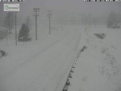
Vermont Agency of Transportation web cam showed a 
snow-free Route 78 in Alburgh around 7 a.m. today.....
The other aspect of this storm that made it not as well behaved as it could have been was the distribution of snow accumulations. Totals aren't final yet, as many areas of Vermont still have an inch or two to go.  

But it appears southern Vermont got quite a bit less snow than forecast. Northern Vermont got about as much as forecast, except for the northern Champlain Valley.  Franklin and northern Grand Isle counties seemed to hit the jackpot.  

There, totals were closing in on ten inches by early evening. As of 5:45 p.m., my yard in St. Albans had received 9.5 inches of snow. Swanton reported 9.5 inches as of 2 p.m., when it was still snowing at a good clip there. Swanton probably ended up with close to a foot. 

Elsewhere in the north, amounts were clustered tightly around 6 to 8 inches as of 4 p.m, so the predicted snowfall of 7 to 10 inches of snow will verify. 

In far southern Vermont, 8.5 inches of snow was reported at Winhall and a little over six inches was reported at Readsboro and Landgrove as of late afternoon. They'll probably pick up only another inch or so of snow, so those predictions of a foot of snow might not happen. Except maybe up toward favored locations around Ludlow, Mount Holly and Shrewsbury. We'll see. 

It looks like the burst of snow this morning in southern Vermont didn't last as long as forecast. Meanwhile, in the north, especially in the upper Champlain Valley and adjacent New York, the heavy snow began earlier than forecast. The heavy stuff was forecast to blow in around 11 a.m, but it was already snowing hard at 8 a.m. The Champlain Valley snow got lighter at around 4 p.m., which was about the time that was expected to happen. 

Snow is still expected to gradually wind down over the next few hours. It'll be over by midnight at the latest. 

We're still going to have a perfect winter day tomorrow, with sunshine, coldish but not frigid temperatures and light winds. 

Sunday is looking problematic.  

....and that same stretch of Route 78 in Alburgh looking
much, much different shortly before 1 p.m. today. 

The first problem Sunday will be wind, especially in the Champlain Valley. The snow that fell today is remarkably light and fluffy. It won't take much wind to blow it around. 

Winds are now expected to gust to 40 mph in the valley.  That will cause blinding ground blizzards in exposed locations, and surprisingly deep drifts on roads

I expect they might actually close the Route 2 causeway between Colchester and South Hero, as there will be vast amounts of powdery snow blowing off the ice covered surface of Lake Champlain. 

The other problem Sunday is a rising chance of brief but heavy snow squalls. First of all, the squalls cut visibility to zero very abruptly, making the chances of highway pileups pretty high. Additionally, temperatures are expected to rise to between 30 and 35 degrees ahead of the likely squalls.

So the first flakes that fall in the squall will melt on the highways. But rapidly falling temperatures will instantly freeze that water, and the blinding snow will accumulate on top of that. So when you hit the brakes when the visibility disappears, you won't stop. You'll just slide into the wreck ahead of you. 

I'll update this as we get closer to the event. 

Wednesday, April 7, 2021

Just Remember: Gorgeous April Weather Could End In Unwanted Karma

Spring surprises. This is what it looked like on April 28, 
2010 in St. Albans, Vermont in what had otherwise been
a warm month. Spring surprises like this happen a lot! 
 Since I'm a glass half empty kind of guy let's throw a bit of cold water on this gorgeous spring week in Vermont.   

Yes, we need the rain, but you can't deny we have entered a period of wonderful early spring weather. It was sunny, with cool but pleasant breezes Sunday through Tuesday. 

For the rest of the week, it'll be in the 60s for most of us, which is at least 10 degrees above normal. The sunshine will continue. 

Yet, April is fickle to say the least, and we can still get some awful throwbacks to winter. I'm not saying it's going to happen, but there's always that risk. 

It's always fun to consult "The Vermont Weather Book" by David Ludlum to find the "it can always be worse" stories. 

Probably the crappiest April in Vermont history was 1874.  Several snowstorms struck the state that month, the biggest of which was on April 26, near the close of the month.  Bellows Falls had two feet of new snow, and low elevation Burlington still managed nine inches.

It snowed again on April 30, 1874. Sleighs were still running on the streets of Woodstock, and nearly three feet of snow remained on the ground in St. Johnsbury.  

In modern times, the greatest April snowfall on record, at least in Burlington, came on the 16th and 17th in 1983. That storm dumped 15.6 inches on the city. 

On April, 27-28 2010, which was actually an unusually warm month, snow hit parts of Vermont, especially the northern Champlain Valley hit while trees were prematurely leafing out. Burlington received 5.3 inches and 10 inches clobbered St. Albans.  Particularly around St. Albans, there weas heavy tree damage as the weight of the snow on partially leafed out trees was too much. 

Typical of the season, though, it was back up to the mid 70s by May 1 and in the mid-80s by May 2.  

You think we're done with subzero cold?  Nope! It's still possible, but frankly not in the cards this year. On April 5, 1954, it was 12 below in Lemington, Vermont and 10 below in West Burke.  It warmed up a couple days later and the rest of April, 1954 was kind of average, so that was good, I suppose.

It was almost as cold in April, 1972.  It got down to 2 above in Burlington, still the record for coldest reading in April there. It was 2 below in Enosburg Falls, and there was still 39 inches of snow left on the ground in high-elevation Peru, Vermont that day. 

What had been an early spring being interrupted by a snowstorm
on April 28, 2010 in St. Albans, Vermont

Unlike in 1954, it never really warmed up all that much later in April, 1972.  Most days for the rest of the month only made it into 40s to around 50 for the rest of the month.  

All but four nights that month got below freezing. I bet the trees were awfully late leafing out that year. 

April can be extreme the other way, too.  There's been at least a couple notable hot spells this time of year, too.

On April 18 and 19, 1976, high temperature records for the month were shattered as it got to 91 degrees in Burlington, which was then by far the earliest 90 degree reading on record. Vernon reached a remarkable 97 degrees.

Consistent with April, however, a little over a week after that heat wave, it snowed a little.

On April 17, 2002, another early season heat wave set a new record for earliest 90 degree reading on record in Burlington. Same thing as in 1976. It snowed a few days later. On top of that, a very hard freeze damaged premature tree leaves and fruit tree blooms.

This April, forecasts call for temperatures to remain above normal for about a week.  Then a possible change in the weather pattern is likely after that.  Will we receive our (inevitable?) late April snows and frosts? Time will tell, but Vermont's track record in this regard makes me think we will. 

Thursday, January 21, 2021

"Dry" Weather Pattern Is Surprisingly Snowy In Vermont.

It's not the most snow I've ever seen on my weather deck
in St. Albans, Vermont. But repeated snowfalls, many
of them surprises, have left me with a snow depth
of 10 inches or so. Was snowing again when I took this pic.
 Well, I didn't expect that! 

I woke up to a fresh 2.4 inches of snow yesterday morning at my St. Albans, Vermont hacienda. I knew we'd have some flurries, and I was expected a dusting, but no bonafide gotta clear the driveway snow. 

So I shoveled, signed on into work, and glancing out my window, I saw that it started snowing again. A lot. That was good for another 2.5 inches of snow that needed shoveling. No worries, I needed the exercise. 

The bottom line was a hair under 5 inches of new snow that came on a day that less than an inch was forecast. It wasn't just St. Albans.  Up in Eden, they reported six inches of new snow in just three hours yesterday morning. Barton also collected six inches of snow by mid morning. 

Almost four inches fell in Milton, by 7:30 a.m. and that was before another burst of heavy snow blew through. 

After the weekend storm ended, Burlington got surprise snowfalls of 4.2 inches Monday and 2.6 inches yesterday. 

And, as I write this mid-morning Thursday, it is snowing once again. 

Where's all this unexpected snow coming from?

Small storms and disturbances zipping in from the west and northwest are the basic cause, but these weak little things aren't usually able to give us much more than a few flurries. Of course, some of these disturbances have had a little more oomph than usual, which helps wring out a little extra snow.

I have a feeling that the warm winter we've had is partly to blame, or credit depending upon your perspective. 

This winter's warmth hasn't been limited to just around here in Vermont. It's been warm across the Great Lakes, and in Quebec and Ontario. That has left much less ice on lakes in these areas than you'd expect in mid-January. 

I think that weak disturbance that are destined to give us light snow and flurries have been able to grab some moisture from the open waters of the Great Lakes, Lake Champlain, and some bodies of water to our northwest. 

This has helped enhance the snowfall. 

A lot of the accumulation has been fluffy too. Unlike the wet snow we had last weekend, the snow so far this week has been really fluffy, and does not have much water in it. The nearly seven inches of snow in Burlington since late Sunday night didn't even quite contain a third of an inch of liquid equivalent. 

"Dry" snow like this accumulates pretty fast, though it eventually settles quite a bit. 

Despite the lack of big storms, it looks like we're in for more snowfall. This morning's snow will tend to taper off a bit this afternoon, only to reblossom for a time tonight. 

A cold front tomorrow afternoon will set off even more snow showers, some locally heavy. Then, cold winds from the northwest will trigger even more snow Friday night and Saturday, mostly over the Green Mountains and western slopes. 

This will add up in the mountains.  Valleys should get one to four inches of new snow between now and Saturday evening, with locally higher amounts.  The Connecticut Valley could get even less than that. West and northwest winds tend to block moisture from places east of the Green Mountains. 

Those mountains, though, especially from Killington north, could wind up with an additional six to 12 inches by Saturday. 

Even drier, colder air should work in by this weekend, limiting snowfall for Sunday onward for a time. It looks like storms coming across the nation from the Southwest between now and the middle of next week will pass by too far south to bother us (Though I've been surprised before.......)

I can't say I'm really complaining about the snow.  Now, it looks like January out there, and the winter sports fan are surely gleeful about things. We're now all set for skiing, riding, snowshoeing and for snowmobiles. 

After a very slow start to winter, we're finally getting close to being up to snuff here in Vermont.