Wednesday, September 30, 2020

Yet Another New England Storm Overperforms: Torrential Rains and High Winds

This really seems to be a pattern we've fallen into:  We go a long time between decent rains, and then when one finally hits, we really get nailed. 

On a dark drizzly Wednesday morning after a night of heavy rain
rapidly changing leaves try to brighten things up a bit im
my St. Albans, Vermont yard. 

The storm system and cold front that is still going through has really over performed here in Vermont.   Rainfall was unexpectedly heavy, especially from from the Green Mountains west. 

About one to two inches of rain had been forecast. Instead, I'm confident that there will be isolated totals of up to four inches.  Many areas certainly got more than two inches. 

It was still raining at 7 a.m., though the heaviest rain was moving on at the time. 

As of 7 a.m. Montpelier reported 3.31 inches. Morrisville had gotten 2.38 inches. Burlington was just shy of two inches. My unofficial rain gauge in St. Albans, Vermont collected 2.7 inches. 

As of 6 a.m., flood advisories were up for the southern two counties of Vermont, where just under four inches of rain was reported in the southern tip of the state, up in the Green Mountains. 

This storm would have probably caused some flooding had soil moistures and river levels been normal ahead of the storm.  For the second time in less than two months, weeks of dry weather preceding a super wet storm prevented high water. In early August, Tropical Storm Isaias dumped two to four inches of rain on western Vermont. 

Even with the preceding droughts, the downpours, especially the heavier ones in the pre-dawn hours, probably caused some minor damage to dirt roads and gravel driveways. 

This all was caused by deep tropical moisture riding northward along a very slow moving cold front crossing Vermont.  It usually takes under four hours for a cold front to pass through Vermont. 

This cold front reached the northwest corner of Vermont early Tuesday afternoon. The front didn't cross the Connecticut River into New Hampshire until around 6:30 or 7 a.m today.  

This slow movement left plenty of time for the downpours to linger over Vermont overnight and early this morning.  

Ahead of the cold front, strong southerly winds are causing power outages in the eastern half of New England.  These winds affected Vermont, too, mostly in the southern part of the state. About 6,000 homes and businesses in Vermont were without electricity as of 8 a.m. today, mostly south and east of a Rutland to St. Johnsbury line. 

Lighter rains will continue off and on today, so that will be good for the still dry groundwater. One big rain storm like this is not nearly enough to erase a drought. It certainly helps, but we'll need rainy weather for the rest of the autumn to get things back on track. 

Some more rain is likely Friday, but there won't be blockbuster totals like we got last night. That one will amount to a half inch of rain or less. 

Early indications are that after a cool weekend, we might return to warmish weather and a return to drier than average weather as we head into the second week of October. 


Tuesday, September 29, 2020

Fingers Crossed For A Nice Soaking Vermont/New England Rain Tonight

 It's a partly sunny start to this Tuesday  morning here in St. Albans, Vermont, but meteorologists across the board are still promising us a to die for soaking rain later today, tonight and Wednesday morning. 

Our property in St. Albans, Vermont looked all nicely dressed
up for autumn Monday evening after some light, 
refreshing rains during the day. 

When all is said and done, the forecasters say we will have had one to two inches of rain. 

That won't solve the deep dryness and drought we're experiencing, but at least it will stop it from worsening, and help us recover a bit. 

We'll still need more soggy storms through October, November and into December to erase the drought, so we'll see about that. 

Some of us here in Vermont managed to get some largely unexpected "appetizer" showers on Monday. 

Here in St. Albans, I think we were one of the wetter spots, collecting 0.20 inches of rain.  That's not much, but at least it helped keep the dust down.  Burlington only squeezed out 0.03 inches. Springfield managed 0.15 inch and Montpelier got a 0.06 inch drizzling. Rutland got nothing. 

Today, the band of rain coming in from the west with a cold front is looking pretty narrow.  Normally, that means it wouldn't rain for long, and we wouldn't get much. 

However, this area of rain's forward progress is quite slow, so it would linger over us for hours. Plus, it's oddly humid for this time of year and gusty south winds are bringing in plenty more moisture. So there's a lot of water that can be wrung out of the sky with this cold front. 

With Vermont rivers running so incredibly low, some of the lowest I've ever seen, there is absolutely no chance of flooding with this.  The only water problems I foresee are possibly bits of street flooding in urban areas as storm drains get clogged with fallen leaves during the heavier downpours.

East of the Green Mountains especially, and most of eastern New England should see some rather strong gusty winds later tonight and Wednesday ahead of the cold front. 

Yesterday's rain briefly cleared the smoke and haze out of the air toward the end of the day Monday, but I notice the haze is back this morning. I hoping this heavier rain will bring back some deep blue skies poking between shower clouds for the second half of this week. 

The rain isn't necessarily over on Wednesday, either, but the amount of further wetting is uncertain. 

It'll be cooler, obviously, on Wednesday and Thursday after the cold front goes by, but it won't be anything odd for this time of year. A reinforcing shot of chilly air could trigger more rain Friday (fingers crossed!).

As I always caution, longer range forecasts are always iffy.  Beyond the end of this week and through next week, I don't see a lot of signals for more deep soakings, but there are at chances of rain here and there as disturbances rotate through.

It looks like it will be chillier than average this weekend and next week.  It's definitely possible that some of the precipitation coming through next week could fall as a little snow, yes snow, on the mountain peaks. 

By the way, this is getting into October so don't be shocked by the "S" word. We very often get mountaintop snow during the first week of October in Vermont. Deal with it. 

Monday, September 28, 2020

California WIldfire Nightmare Stuck On Repeat; Santa Rosa Again?

 In 2017, the so-called Tubbs Fire roared into the city of Santa Rosa, California, killing 22 people and destroying some 7,500 people.   It was one of the most apocalyptic wildfires in California history. 

I bring this up because, to an extent, history is replaying itself in the Napa Valley and Santa Rosa just three years after the Tubbs fire. 

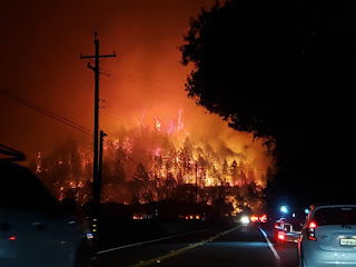
A raging wildfire overnight near St. Helena
California. Photo via Twitter by Caroline Garcia.

Homes are burning, wineries are destroyed and thousands of people are fleeing from wildfires that blew up yesterday and last night in the same areas wrecked by the Tubbs fire. 

California just can't catch a break. 

So far at least, the current devastating wildfires are likely not quite as destructive as the Tubbs fire. 

That's not much comfort, though, for people who have lost their homes and businesses in the past couple of days. Not to mention the thousands of homes destroyed in the West during this extreme fire season of 2020.  Nothing is going right in 2020. 

I can only imagine the horror and PTSD spikes going on with people who lived through the fires of 2017, only to experience the exact same thing again now. 

Since this is a breaking story and people can't really get into the danger zone to assess the damage, we don't know how bad this latest outbreak of fires is. There are plenty of videos and photos on social media of homes and businesses burning.

There are also videos of harrowing drives through flames as people frantically evacuate. Unfortunately, we've gotten used to those videos this year. 

These repeated fires will certainly affect California's economy, population and society for years to come.  I can imagine people - including those who have never had their homes damaged by wildfires - will give up on California and move away. 

The Chateau Boswell winery near St. Helena,
California in flames Sunday.

Who wants to live in a place where you're constantly evacuating or under threat of evacuations?  A place that's hazardously polluted from wildfire smoke for weeks or even months on end every summer and autumn?

In the short term, anyway, the fires will continue to rage today under hot, dry, windy conditions. The weather will turn a little better in northern California later in the week. The winds will be lighter, which is a good thing. 

The fires will continue to burn, though and could explode once again if any other bouts of strong east winds develop, which could easily happen at any time during the next two weeks at least. 

There is no rain in the forecast anywhere in the western third of the United States for at least the next week, except for light showers in northwestern Washington.

Wildfire smoke will continue to drift its way across the United States for the foreseeable future, giving large areas of the nation hazy skies. 

I notice some wildfire smoke overhead in Vermont this morning, making this the eight consecutive day we've noticed the smoke in the atmosphere over the Green Mountain State. 

The fire danger here was fairly high yesterday, but clouds and moist air kept the danger limited in parts of Vermont. We're still looking at a good chance of a decent rainfall later Tuesday into Wedneday morning.

Sunday, September 27, 2020

Vermont Fire Danger Today, And Western Wildfires REALLY Ramping Up

We've been watching the wildfires out west with horror most of the summer and so far all this autumn.

Now, in a much more minor way, it's our turn in Vermont to worry about fires. Luckily the threat likely will only last a day or two. 

As mentioned in previous posts, the drought in New England has gotten worse this month as we've had virtually no rain since late August.

The weeds and brush have dried out, a process that was accelerated by last weekend's frosts. Dry, fallen leaves are accumulating on the ground. 

Today will be another dry day, and the wind will blow pretty briskly. That's a great recipe for starting a brush or forest fire.  Forget the campfires, the brush burns and such today, as you could easily start a fire. 

This situation isn't nearly as bad as out west.  The relative humidity today will be around 50%, not the 10% or less out in some of the western fire zones.  Though we're having a drought, it's not as bad as in much of the West. We don't have stands of thousands of dead trees like they have in places like California. 

Drought has killed trees in California and weakened many more. Those weakened trees are then murdered by bark beetles.

Still, we in Vermont have to take care today.  The National Weather Service in South Burlington says there's a high fire danger statewide today.   Not the day to throw cigarette butts out your car window, but then again NO day is the right day to do that. Take care of your own damn litter.  

The good news is forecasters are still expected some decent rains around here Tuesday night and Wednesday. While the expected rain won't be nearly enough to erase our drought conditions, at least it will wet things down and limit the fire danger. 

No such luck out west. 

As reported earlier, hot windy weather has established itself across many parts of the West, and that will continue pretty much all week.  

WPTZ-TV meteorologist Ben Frechette posted
to Twitter this photo of a parched hillside in
Vermont's Northeast Kingdom, helping to 
illustrate the current fire danger in the state.

That snowfall in Colorado early this month did little good. As soon as that cleared out, it turned hot and dry again for the rest of the month out there. 

A big blaze west of Fort Collins has become Colorado's third largest wildfire in history.  Mandatory evacuations are up for subdivisions in the mountains near the fire. Fort Collins and Denver, among other cities, are shrouded in smoke, causing dangerous spikes in air pollution. 

This fire started August 13, but got a lot worse the past couple of days due to high temperatures, low humidity and strong, gusty winds. 

Firefighters have been struggling for weeks with fires in northern California. They've gotten to the point of being partly contained. But starting this morning and going through Monday, hot, dry east winds are expected to fan those fires back out of control. New, dangerous fires might also develop under these extreme weather conditions. 

At least one new fire erupted in the Napa wine country area early this morning, prompting evacuations. 

In southern California, hot, dry, strong Santa Ana winds will make things dangerous most of the upcoming week. 

Unlike in Vermont, pretty much no rain is in the forecast for at least the next seven days anywhere west of a line from the Montana/North Dakota border down to the Rio Grande Valley in Texas. 

Saturday, September 26, 2020

Classic Indian Summer This Weekend In Vermont

Indian Summer is a period of warm, dry, often hazy weather in the autumn following some of the first freezes of the season. 

Even the fading perennials in my St. Albans,
Vermont gardens are adding color to the
landscape as autumn progresses. Expect
Indian Summer type weather this weekend

By that definition, we've got a classic Indian Summer going on right now. 

As we all know, the growing season ended in most of Vermont last weekend as some record cold descended on the Green Mountain State. We had a bunch of frosty mornings there. 

It has warmed up nicely in the past few days, and it will get even warmer for the weekend. 

Meanwhile, the  fall foliage is really popping, especially in the Northeast Kingdom and the higher elevations of the Green Mountains, so get out there and enjoy. 

I think the drought conditions are helping promote the brilliant reds in some of the trees, making the foliage more brilliant. I guess that's a rare positive in the bad news drought we're experiencing in New England. 

All this is part of that amplified weather pattern we've been talking about, the one that will bring hot, dry, windy weather to the West. That is worsening those wildfires out there. Those wildfires will maintain the haze here, as the smoke is blowing across the nation. 

Just to be clear, just because I like Indian Summer a LOT, I do hate that the haze is coming from the wildfires. I'm sure we'd happily live without the haze if it meant no destructive wildfires. 

Temperatures this weekend and the start of the week will actually be pretty close to normal for mid-summer, not the end of September.  Daytime highs will be in the mid 70s to low 80s and lows will be in the 50s to low 60s. 

South winds will be increasing all weekend. Since it's so dry, don't do any outdoor burning, and be extremely careful with campfires, cookouts, discarded cigarettes and such.  You could start a forest fire. 

It's true that the humidity will be increasing somewhat this weekend, so it won't be "perfect" conditions for fires, but it will be bad enough  to make you want to take precautions. 

Meteorologists, looking at ever evolving data, have been forced to greatly postpone the onset of any rain we might get. Originally, early in the week, they were talking about rain coming in Sunday afternoon or evening. That rain has now been pushed back to Tuesday afternoon or evening. 

As delightful as the weather will be this weekend, I am so ready for a good soaking rain to limit the dust out there and perhaps begin to recover just a bit from the drought. 

Friday, September 25, 2020

New England Drought Worsens: Praying For Wetter Pattern Next Week

 A drought that has been lingering over New England and some other parts of the Northeast is worsening.  

A drought is worsening in the Northeast.
The darker the color on the map, the worse
the drought. 

This includes Vermont, of course. 

According to the latest weekly U.S. Drought Monitor, released Thursday, almost all of New England, much of New York and a good chunk of Pennsylvania are in drought. 

As of Thursday, all of Vermont except a small corner of Rutland County is at least abnormally dry. The eastern two -thirds is in moderate drought. The Connecticut River Valley from about White River Junction north was upgraded to severe drought with this week's Drought Monitor update. 

If you think things are bad in Vermont, it's even worse in the eastern half of New England. All of Rhode Island, and adjacent parts of Connecticut and Massachusetts, southeastern New Hampshire and southwestern and northeastern Maine are in extreme drought. 

The U.S. Drought Monitor has a five point scale representing drought conditions. Going from not so bad to terrible, the ratings are, abnormally dry, moderate drought, severe drought, extreme drought and exceptional drought. 

Thankfully, no parts of New England are in exceptional drought, at least not yet. 

The current New England drought is definitely having some real-world consequences. Some of the hardest hit areas are having wells run dry with new ones having to be dug. Pretty much region wide, pasture lands and crops are suffering. Forest fires are starting to break out throughout New England.

Vermont is faring badly, but not as badly as further east because Tropical Storm Isaias dumped some heavy rains west of the Green Mountains in early August. Also, dying cold fronts made it into Vermont occasionally over the summer. These fronts dumped scattered downpours in the Green Mountain State before evaporating on the way past the Connecticut River. 

Things have definitely worsened in September, as we have had virtually no rain. Unless some predicted good rains materialize on the final couple of days of the month, which is possible, many New England towns and cities, including most of Vermont, will have their driest September on record. 

As has been the case all summer, any rain that comes in during the beginning of the week is most likely in Vermont, and less likely in eastern New England.

It's also unclear how much rain will come. Many computer models spit out a decent amount of rain locally, with the possibility of 1.5 inches of precipitation between Monday and Wednesday. Of course, that's no guarantee.

Those computer models have been trending the precipitation further and further west as we get closer to the event, which risks making us miss out 

Even if we get a good soaking next week, that would not come close to solving the problem.  The ground is super dry, groundwater is lacking.  It would take a tremendously wet autumn to get back to normal.

Here's something to illustrate. I have 15-inch deep raised beds on my property. I dug through one fallow raised bed that I hadn't watered all year.  It was basically dust for the whole 15" of soil, and the clay earth below that was also bone dry at depth of at least three inches. (I didn't dig any deeper than that).

Also, in an area in back of my house, it's usually swampy. Every time I go up there, I sink into the mud.  Now, that area is also dry as a bone. This isn't good. 

The New England drought isn't as bad or as widespread as the one out in the western United States. But, it will be nasty deep in this winter if we don't get decent autumn rains. Imagine a well going dry during a 20 below cold snap in January?

I for one, will be doing rain dances for awhile. 


Thursday, September 24, 2020

New Top U.S. Weather Agency Heads Are Not Great For Climate Change Science

Two recent Trump administration appointments to national weather and climate agencies are consistent with the president's climate change denial, but not necessarily consistent with the science. 


Earlier this month, Trump appointed David Legates, for the top position at the National Oceanic and Atmospheric Administration, or NOAA. 

The administration also appointed Ryan Maue as chief scientist at NOAA.  Maue understands that climate change is real but often criticizes people he calls "alarmist," who are concerned about climate change. 

According to NPR, Legates is now deputy assistant secretary of commerce for observation and prediction. He reports directly to Neil Jacobs, the acting head of NOAA. 

While Legates will not be the head honcho of NOAA, he'll certainly have a lot of influence.  That influence includes a long legacy in which Legates doubts climate change and that humans are causing it. 

Some of Legates' history, includes this, according to NPR: 

"Legates also appeared in a video pushing discredited theory that the cause of global warming. In testimony before the U.S. Senate in 2014, Legates argued that a climate science report by the U.N. Intergovernmental Panel on Climate Change erroneously stated that humans are causing global warming."

Critics are slamming the Legates appointment. As NPR reports:

"'He's not just in left field - he's not even near the ballpark,' says Jane Lubchenco, a professor of marine biology at Oregon State University and head of NOAA under President Barack Obama."

Lubchenco went on to say contrarians are welcome in the science community, but the claims must be scientifically defensible.  

Maue, the new chief scientist at NOAA, is the more nuanced than Legates.  He's definitely respected in the meteorology field, but can be combative with people over aspects of climate change science, though as noted, Maue acknowledges climate change is real.  

Here's some of what Science magazine has to say about Maue:

"He routinely challenges scientists who connect global warming to real-world consequences, such as more intense hurricanes. This area of study - known as attribution science - is a relatively new but growing field. 

'If you question the efficacy of attribution science, then you risk being smeared and censored, he wrote on Twitter earlier this year. 

According to Science, Maue has said he agrees with the concept of "lukewarming" which rejects the more dire projections of global warming.  Reports Science:

"'Lukewarming is not climate denial....Most of us on this side of the issue believe in lower climate sensitivity. We don't believe there is going to be 5 degrees of warming; we figure it's at the lower end of 1.5 degrees."

Maue occasionally delves into politics. He baselessly accused reporters of giving Democratic presidential nominee Joe Bide questions ahead of a recent press conference.

'He has the questions ahead of time and is using his notes to answer,' Maue tweeted."

On the other hand, Maue is not exactly afraid to ding the Trump administration, either. As Science and a lot of other media have reported, during the "Sharpiegate" scandal last year, Trump displayed a hurricane tracking map that was altered with a marker to show Hurricane Dorian hitting Alabama. Senior NOAA officials provided cover for the president, ignoring the accurate forecasts from a National Weather Service in Alabama that said Dorian would miss that state. 

Maue tweeted: "Whoa! Nothing like throwing your Alabama NWS office under the bus."

It is of course unclear whether Trump will stay in office, seize control through undemocratic means, or will Joe Biden win? Like everything these days the future of NOAA and climate science is in the great unknown, 


Wednesday, September 23, 2020

Weather Pattern Change: Horrible News For West, Not Bad News For Vermonters

As it tends to do, the weather pattern can get a little more variable in the autumn, and things are going to shake up a little bit over the next few days.  Unfortunately, that pattern will then get somewhat stuck for awhile, which has some dangerous implications for the western United States. 

A dim sun, obscured by lots of western wildfire
smoke overhead, sets behind power lines
Tuesday evening in St. Albans, Vermont.

All of us are aware that the west continues to burn.  Plumes of smoke are still crossing the nation.  That's why it was so hazy overhead yesterday here in Vermont. Another big huge puff of smoke blew our way.

The west will see another big, hot ridge of high pressure bloom overhead. The process will be gradual over the next few days, but by the very end of September and the first week or more of October, that heat ridge will be well established. 

Rainfall in recent days has helped somewhat in the western half of Washington and northwestern Oregon, but everybody else on the West Coast has been pretty dry. California doesn't normally see much in the rainfall until much later in the autumn anyway.  

This upcoming pattern will bring the heat to the west, and also east winds blowing toward the Pacific Ocean.  You don't want that. Firefighters need cool, damp breezes from the Pacific Ocean. That doesn't look like that's in the cards for the upcoming couple of weeks. 

Cold fronts and storms forming much east of the Rockies will help send pushes of very strong, dry east winds into parts of California and maybe Oregon and western Washington at times .

This is a recipe for more mega-fires, as if the West hasn't seen enough already. We know California has already had a record fire year, and they are now just entering what is normally peak fire season.  This won't be good. 

There will be a corresponding big southward dip in the jet stream with this set up. That will keep the Midwest, and eventually probably the Northeast cooler than normal. 

It also gives us Vermonters a shot of getting some needed rain. Up until now, Burlington, Vermont is on pace for having the driest September on record. The driest September on record has only 0.68 inches of rain, in 1927.

Not-fun fact: September of 1927 was super dry, but most of us know what happened a couple months later. The Great Flood of 1927 hit on November 3-4, 1927.  I'm not at all saying history will repeat itself, but still, shudder. 

Anyway, this shifting weather pattern gives us some shots at possibly decent rains to close out the month. I, for one, am happy we're probably losing a chance to break another weather record. I want rain! 

So does practically everyone else in Vermont. The state's vast forests are usually kind of hard to burn, That's especially true if you're talking about deep, serious burns that don't just race across the surface.

The organic material in Vermont forests usually stays wet enough so that nothing beyond leaf litter burns during occasion dry spells.  Our tree filled landscape has more than once been called the "asbestos forest."

It's so dry now that we're starting to get the rare fires that burn deep under logs and roots. There's such a fire burning now near Killington, though fortunately it was discovered early so it didn't spread much beyond a half acre.  In a worst case scenario, this type of fire can blow up to become a real nasty one. 

The upcoming weather pattern makes it more likely, but not definite, that we will have more rainfalls in the first half of October. We shall see.

Long range forecasts, as I always note, are dicey. So there will be shifts in the forecast heading into October. 

I sure hope that heat ridge in the west is being overdone by computer forecasting models. By the same token, I sure hope we enter a rainy pattern heading into the autumn to replenish ground water reserves here in Vermont. 

If there's another bright side, there are hints that California could receive some rain in mid-October. We shall see. 

Tuesday, September 22, 2020

Tropics Stay Weird. Also Fire Danger In New England Of All Places

There's a tropical storm watch today in frigid Newfoundland. Another tropical storm rose from the dead nearly a week after dissipating. Yet another one is pretty sitting and spinning over the same location, unleashing dangerous floods. 

Gorgeous satellite view of the Northeast this
morning. Big curved cloud shield is outer
edge of Hurricane Teddy. Just west of 
that cloud shield over Vermont that got
entrained in Teddy's circulation.Then
there's a narrow band of smoke-free
air in northeastern New York, with
more smoke coming in behind it from 
the west.

The weird tropical storm season of 2020 continues on. I'l also get to the fire danger in a bit, which is in part being caused by yes, a hurricane. 

TROPICAL STORM BETA 

I'll start with the relatively "least" weird one first. Tropical Storm Beta splashed ashore along the mid Texas coast last night. Maximum winds were estimated to be near 50 mph, and I think even that was generous. 

The problem is Beta is stalling just inland, and is drawing feeder bands of torrential rain into the Texas coast and into southwestern Louisiana all day today and into tomorrow.

This location can NOT be worse than it is.  Houston, still traumatized by the extreme Hurricane Harvey floods of 2017,  is at a high risk of some substantial flash flooding today. It won't be as bad as Harvey, but that's not much comfort. 

Three to six inches of rain has already fallen around Houston as of early this morning, and at least another four inches is due today. Flash flooding is already ongoing in the massive Houston area, and that is likely to get worse as the day goes on. Flood warnings are up for most area creeks and rivers.  There are lingering storm surges along the coast, and that would limit the ability of creeks and bayous to drain into the Gulf of Mexico.

The torrential rains are likely to move into southwestern Louisiana which was totally wrecked by Hurricane Laura last month. Those tarps over destroyed roofs might not hold up to this much rain, adding to the wreckage of severely damaged houses. Renewed flooding will interfere with hurricane cleanup, and create added damage.  

TROPICAL STORM PAULETTE

This one has risen from the dead. Over a week ago, Hurricane Paulette smacked Bermuda with 90 mph winds, then raced off to the North Atlantic Ocean to die in the cold waters up there. 

Turns out Paulette is some kind of zombie. The remains of Paulette moved south into somewhat warmer waters kind of near the Azores. As of last night, it was reborn as a 60 mph tropical storm.

Paulette has turned east heading slowly toward southern Portugal, but will never get there. Cooler ocean water and high upper level winds should kill Paulette again over the next few days. However, there are some suggestions that its remains could turn on a dime and move westward again. 

If the ghost of Paulette gets far enough west and loses the upper level winds, who knows? It could become a zombie storm again. That's unlikely, but the way this year is going, you never know. 

HURRICANE TEDDY

Hurricane Teddy is gradually losing its tropical characteristics, but is still only half way through that process. When hurricanes do this, their areas of high winds expand.  Teddy is moving north toward Nova Scotia and is expected to give them a pretty nasty blow later today, and the bad weather will move up toward Newfoundland tomorrow. 

As of early this morning, Teddy still had top winds of 105 mph, and hurricane force winds extended as far as 100 miles from its center. That's a big area for a hurricane. 

That set up is helping Tedday cause huge waves and elevated water levels along the Atlantic Coast from Newfoundland to Florida. Coastal flooding is ongoing up and down the East Coast, even as skies remain sunny well outside Teddy's core of clouds and rain.

New England is on the western edge of Teddy's expanding wind field, so breezy to gusty north winds will come through today, especially east of the Connecticut River.

New England is in a drought. The winds today, gusting to 30 mph or more in the eastern half of the region,  could help spread any fires that start.  So I guess we're getting a very mini version of what's been going on in the western United States for weeks now. 

Red flag warnings that indicate fire danger are up for almost all of New Hampshire, Massachusetts, Rhode Island and southwestern Maine. 

Here in Vermont, the fire danger isn't quite as high because the wind will be lighter than areas to our east. However, the northerly breezes, low humidity and especially the very dry conditions from this month's lack of rain raises the risk of fires. 

Note that smoke from western wildfires is getting caught up in Teddy's circulation, so we will be back to smoky skies overhead, especially this afternoon. We first started noticing this return to smoke overhead yesterday, ,and I think it might thicken up some this afternoon. 

Some relief from the dry weather is possibly due later in the weekend and early next week. Two fairlky wet cold fronts, one Sunday night, the other Monday night and Tuesday, have the potential at least to give us some decent rains for once. 

Monday, September 21, 2020

Vermont To Warm Up, But Smoke Returning

The early season cool spell in Vermont is about to end, but the price we pay will be an end to those deep blue skies we had over the past few days. 

The deep blue sky we've seen over Vermont 
the past few days will be replaced by 
those smoky skies again this week. 

It will be back to smoky skies for awhile. 

This chilly spell set record lows throughout the Northeast, including here in Vermont. 

 Both Montpelier and St. Johnsbury reached record lows for three days in a row. 

On Saturday in Montpelier,  it was 27 degrees, breaking the date record of 29 degrees set in 1959. It was 27 degrees in Montpelier again Sunday, breaking the record of 29 set in 1964. This morning, Montpelier got down to a bone chilling 26 degrees, breaking the record of 28 degrees in 1966.

Elsewhere, St. Johnsbury reached 28 degrees Saturday, breaking the record low of 29, set in 2014. Sunday in St. Johnsbury brought another 29 degrees, breaking the old record of 34 degrees set in 2009. It was 28 degrees in St. Johnsbury this morning, breaking the previous record of 34 degrees.

It is really unusual for records to be set three days in a row. Especially record lows, as climate change has brought generally higher temperatures. This weekend proved,  however, that cold spells can certainly happen during our modern warmer regime.

Burlington managed to stay barely above freezing each night of the past three, so unlike in most of Vermont, Burlington's growing season is at least kinda, sort of, goes on. The last time it was 32 degrees in Burlington was May 9.  It won't get to freezing again for more than a week. At least in Burlington.

Some frost and freezes will hit parts of Vermont tomorrow morning, but it won't be as widespread as the past few nights. After that, expect no frosts through next weekend. Of course, your garden is probabl ruined by now, but if anything survived, they'll be safe for awhile. 

As I mentioned already, the upcoming warming trend comes at a price. Actually two prices. For one, those deep blue skies will fade some with smoke aloft, starting today. It'll probably last most of the week. 

The second price is a continued lack of rain. It hasn't really rained all month, and pretty much none is coming for a good week. It might sprinkle a bit Thursday in a few spots in the north, but that's about it. The next chance of any real rain will come in about a week.


Sunday, September 20, 2020

Persistent Wildfire Smoke Likely Killing People, Injuring Lungs

 It'll probably be impossible to count the number of deaths and illnesses caused by the smoke over the past month from all those wildfires in the West, but the situation is definitely creating health problems. 

Given the current fire situation and weather forecasts, this state of  affairs will likely go on for some time yet.   

Dense smoke enshrouds Seattle last week. Photo by
Sigma Sreedharan, via Twitter.

The air quality has improved somewhat over the West in the past couple of days, at least temporarily, but several areas in the northern and central Rockies are still under air quality alerts. 

Smoky, hazy skies still cover much of the United States. 

The air is dangerous and deadly, and was downright scary at times along the West Coast.  Seattle and Portland, Oregon had the worst air quality in the world last week.  I'm sure you saw those images on the news of the creepy orange, dark  daytime photos in the West. 

Street lights stayed on all day, if you drove you needed your headlights, and everybody was warned to stay indoors to avoid the thick pollution. 

According to The Guardian, Stanford University recorded hospital admissions for asthma rose by 10% and strokes jumped by 23% in the days following the first outbreaks of fires. 

Even worse, this is all  happening in the middle of a pandemic.  The pollution very likely makes Covid cases worse, and increased the risk of serious illness for those exposed to the virus. 

In buildings, you want a lot of outside air flowing in to HVAC systems to help flush Covid viruses floating in the air out of the structure. But during these wildfire smoke sieges, HVAC systems had to be switched to recirculate to keep the dangerous wildfire particles out. So much for flushing rooms with outdoor air. 

The smoke was so thick that it would seep into houses, making the indoor air dangerous, too. Air filtration systems sold out quickly. Residents resorted to making "MacGyver Fans" to purify the air. (People are attaching furnace filters to the front of box fans to purify indoor air).

Generally healthy people have a lot of capacity for their lungs to self-heal after dealing with pollution.  As people get older, their lung capacity diminishes.  If pollution is persistent, will a lot of these younger, healthy people end up with lousy lungs at an earlier age than they otherwise would have? 

A lot of scientists say yes.

The longer the exposure to pollution and the thicker the pollution, the worse it gets for the lungs. This is pretty much the fourth summer and autumn in a row with choking wildfire smoke in the west. This isn't good.

The wildfire smoke is not great for mental health, either. Let's face it. This year really sucks. There's Covid, unrest in the streets, massive failures of leadership, tragedies and climate change.

As noted, the wildfire smoke is billowing high up into the atmosphere and blotting out the blue sky coast to coast. Social media was full of posts with photos, and comments on how the haze and smoke was turning an incredibly depressing year into something even worse.

Last week that thick haze was overhead in Vermont, and will probably come back for a time later this week, according to forecasts. 

The smoke was too high up in the atmosphere over the Green Mountain State to really have any health effects on the ground. But the blah skies were and are a constant reminder that climate change is worsening, and everything seems to be going to hell now. 

I was actually relieved when a Canadian cold front rolled through on Friday. Even though the subsequent frost would wreck my gardens, it was so comforting to see blue sky again.

Get used to the smoke, though. And the health hazards. The fires out west continue to burn. Some welcome rain hit the Pacific Northwest over the weekend. California remained dry and on fire. Weather forecasts call for another round of near record heat, wind and dry air over the western United States into early October at least. 

With climate change fires will keep getting worse, not only in the West but elsewhere on Earth as well. Get used to those smoky summer and autumn skies. 

It's just another way climate change is messing with our lives.   

Saturday, September 19, 2020

Boy, It WAS Cold This Morning In New England. More Coming

 Temperatures dropped like a rock last night in Vermont and surrounding areas, even more than some forecasts anticipated. 

Everyone in Vermont had a frost and/or freeze except for places right along Champlain Valley and some of the urban cores, like Burlington. 

Some of these temperatures were ridiculous. Island Pond reached at least 23 degrees. Saranac Lake, New York got down to 21 degrees. Saranac Lake is a notorious cold spot, but here's a bit of perspective: There were nine mornings last January in that Adirondacks town that were actually warmer this morning.

Montpelier reached 28 degrees, breaking a record low for the date by one degree.

Editor's Note: Because new Blogger is extremely glitchy and bad, and they're not interested in fixing anything, we are apparently no longer allowed to caption photos. Photo in this post is my truck windshield, very definitely iced in this Saturday morning. 

We've got two more nights of this to go, so this is an odd one.  Usually, a freeze this time of year hits on one night and it's gone. 

A few clouds tonight could make Sunday morning's lows a tiny bit warmer than this morning, but still, most of us will get another frost and freeze. Monday morning looks as if it will be as cold as this morning, so yeah, gardens are doomed. 

It will finally warm up next week to readings that are more or less near normal.

The dry weather will continue, too, unfortunately. We'll get little to no rain for at least the next week. Expect the drought to worsen

TROPICS ARE ZOOMING!

Yesterday was probably among the busiest on record for new tropical storms. In the course of just one afternoon, we had new tropical storms Wilfred, Alpha and Beta.

We've already run out of letters for names, so we've moved on to Greek letters.  This is only the second time on record this has happened. The last time, in 2005, we didn't have to move on to Greek letters until the third week in October. 

The only big threat among these three new characters is Beta.  It was the third tropical storm to form on Saturday, and it is threatening the Gulf Coast with potentially drenching rains. 

Beta is going to be one of those dreaded slow movers. It'll sit in basically the same region in the western Gulf of Mexico for a few days.  It might become a hurricane later by Sunday afternoon as it slowly presses toward the central Texas coast 

Once it gets to a point near that coast, chances are it will reverse course and move eastward across the northern Gulf of Mexico. This is all uncertain at this point, so everybody along the Gulf Coast ought to watch this one.  As if they needed another tropical storm or hurricane this year. 

Elsewhere, Subtropical Storm Alpha formed just off the coast of Portugal Saturday.  That's a VERY weird place for any kind of tropical storm to form. I've never seen anything like it. It moved inland into Portugal during the day, causing some damaging winds, flooding and a couple tornadoes.

Tropical Storm Wilfred also formed in the eastern Atlantic Ocean Saturday. The National Hurricane Center is calling it "Woeful Wilfred" because it's weak, disorganized, and expected to dissipate in the next few days. 

Meanwhile, Hurricane Teddy is going to buffet Bermuda before smashing into Nova Scotia while transitioning to a non-tropical storm. 

Teddy will create big waves over the western Atlantic Ocean. Between the storm itself, stiff northeasterly winds on the back side of the storm along the East Coast, and the timing with unusually high astronomical tides, coastal flooding, beach erosion and scary rip currents are likely all up and down the East Coast.

As far south as Charleston, South Carolina, this weather situation will cause some substantial tidal flooding. 

Then there's the ghost of Paulette. That's the hurricane that smacked Bermuda before heading up into the North Atlantic and dying. 

Now, the remnants of Paulette are heading south again and could spin up as a new tropical storm somewhere south of the Azores.

This is one bizarre hurricane season. It's so 2020, isn't it?


Friday, September 18, 2020

Vermonters Should Worry About Frost/Freeze, NOT Hurricane Teddy

 Just a friendly reminder to my fellow Green Mountain Boys and Girls that if you didn't get any frost this morning, you're sure to get a frost and freeze tonight, tomorrow night and the night after.  Protect those outdoor plants if you can. 


Sunday morning will be the coldest.  The coldest hollows could get down to near 20 degrees! Most of the rest of us will be between 26 and 32 degrees. Brrrr! These readings will be near record lows. 

Meanwhile, there might be a few of you out there who heard or saw reports that powerful Hurricane Teddy, way out in the Atlantic Ocean, will take a hard left turn and slam New England next week. 

Be assured that No. Nope. Uh-Uh.  That's not going to happen.  Unless you live up in places like Nova Scotia, Canada. There could be some real problems up there. 

Hurricane Teddy is a beast. As of early this morning, it had top winds of 130 mph, making it a Category 4 storm. It is forecast to be somewhere near Bermuda by Monday morning. That would make it the second time in a week that Bermuda has been lashed by a hurricane in a week. 

By the way, since the EXTREMELY glitchy and "improved" Blogger won't let me caption images today, the photo in this post is a satellite view of Hurricane Teddy out in the open Atlantic Ocean this morning. 

Usually, when a hurricane goes near Bermuda, it afterwards races northeastward out to sea and dies in the cold North Atlantic waters. That's what Hurricane Paulette did last week. 

Especially a couple days ago, the European weather model suggested that Hurricane Teddy would take a hard left turn and slam into New England, heading at us from the east. 

This had echoes of Hurricane Sandy in 2012. You might remember that the European Model was the first by far to tell us that Hurricane Sandy, off the United States east coast, would take a hard left turn and hit New Jersey.  the other weather models didn't pick up on this idea until late in the game. 

Sandy did hit New Jersey and New York, with devastating results. 

Everybody marveled at how accurate the European model was. 

That was then and this is now. For some reason, the European weather model has really struggled with predicting tropical storms and hurricanes this year. 

As of this morning, the European model was really starting to fall in line with the other models. 

True, the European is sort of,  kinda picked up on something A trough of low pressure off the East Coast, plus that massive high pressure system that's causing our frosty weekend, would not allow Teddy to race off to the northeast like Paulette and so many of her siblings. 

Instead, it seems like Teddy will head due north and possibly slam Nova Scotia by early Wednesday.  That will be bad for them, of course, and I hope the forecast changes for their sake 

Teddy might cause some wind and rain for Downeast Maine. It will also cause some rip currents, higher than normal tides and rip currents on New England coastal beaches. 

Also, since tides are already on the high side over the next few days due to astronomical cycles, there is likely to be a fair amount of beach erosion, unfortunately, from Maine to at least as far south as New Jersey. 

For us in Vermont, it appears the worst that Teddy would do to us is throw a few clouds at us, and maybe create some steady, but not strong northerly breezes.

Elsewhere, another  tropical storm is expected to form in the Gulf of Mexico.  It's expected to meander around aimlessly for the next few days. 

Thursday, September 17, 2020

Vermonters Should Do Their Emergency Frost Harvest Today. Drought To Worsen, Too

We here in Vermont are on the cusp of the nastiest September cold wave since at least 2014, and for most of us, the gardening season ends this weekend. 

Look out for repeated frosts and freezes in
Vermont in the next few days, especially
early Saturday and Sunday mornings.

Frost is possible tonight and early Friday morning, then quite likely Saturday and Sunday mornings.  

For many of us, this frost and freeze is coming a good two weeks ahead of normal.  It's too bad, because after a hot summer, some gardens are still giving us produce. That will end. 

I suggest grabbing as much stuff from the gardens as you can today. You can also try covering up your gardens and flowers, but even that might not be enough. It's quite a nasty, long lasting cold wave.

You wouldn't think we're in for any frost trouble if you were outside early this morning. It's kind of mild out there  However, the strong cold front is coming through this morning and early afternoon.  

You also wouldn't think this cold front is heralding much of anything.  It'll come through with virtually no fanfare. Just a few scattered sprinkles and a wind shift.

But the high pressure system coming in is huge, cold and dry. It's coming in from Canada, and it is much stronger than the kind of high pressure areas that usually come in this time of year.  High temperatures this weekend will only be in the 50s for most of us, which is about 15 degrees chillier than normal. Which means temperatures won't have far to go at night to reach frost and freeze levels. 

On top of that, the air with this thing is very dry.  This kind of air is much better at losing whatever heat it has to outer space at night than humid air would.  You'll notice temperatures plunging at sunset each day this weekend.  

It hasn't rained lately, either. The air cools faster at night when the ground is dry, as compared to during cool spells after heavy rains. Couple this with calm winds at night, and this is a perfect recipe for frosts and freezes.  

Even worse, this cold high pressure system is moving slowly, which gives us frosty mornings on at least two consecutive mornings. Some areas will have frost on four consecutive mornings, Friday morning through Monday morning. 

The only places that will probably escape frosts are areas right near Lake Champlain and maybe urban areas, like downtown Burlington. 

On the bright side, this air from Canada should sweep away most of the smoke that's been overhead for the past few days.  That smoke was from all those fires out west, and rode the jet stream to blot out the blue sky all the way to New England and beyond. 

DRY WEATHER

The latest U.S. Drought Monitor came out today and it shows somewhat worsening conditions here in Vermont. Virtually the entire state was either in drought or at least abnormally dry as September began. It basically hasn't rained yet this month. 

In the Connecticut River valley in northeastern Vermont, the drought has worsened from "moderate" to "severe" in the past week.

Hazy skies over South Burlington, Vermont
on Wednesday due to smoke aloft from
western U.S. forest fires.  The upcoming
cold wave will sweep away some of the haze,
but Vermont has its own, more minor
forest fire risk now

For instance, Burlington has had only 0.22 inches of rain so far this month. We should have had about 1.8 inches by this point in September. 

Aside from today's sprinkles, no rain is in the forecast for at least a week. We'll have that cold, dry spell this weekend, then that high pressure system will stall nearly overhead for the first half of next week. 

It'll warm up, but the rain will stay away.  Another cold front could arrive in a week, but that one looks like it will be mostly dry like the one we're having today. 

I'm beginning to worry we could start to see a few brush and forest fires erupt in Vermont, especially now that dry leaves are starting to fall and the weeds are drying out too.  

We won't have anything nearly as bad as the cataclysmic fires in the western United States.  We've had many wildfires over the years in the Green Mountain State, but nothing extremely widespread since before 1920.

Still, be careful with outdoor burning,  you could set a fire. That'll be the state of affairs until we get some decent rains. 


Wednesday, September 16, 2020

Hurricane Sally Strengthened At Landfall; Flooding Intensifies, Spreads

Hurricane Sally made landfall early this morning right around Gulf Shores, Alabama. Based on early videos from news outlets and social media, there's once again LOTS of damage with this one. 

Inside a home flooded by
Hurricane Sally in Foley,
Alabama this morning.
Photo by Cambri Radford
via Twitter

Following a trend this hurricane season, Sally strengthened some just prior to landfall.  Top sustained winds had been holding near 85 mph during the day Tuesday, but ramped up to 105 mph just before landfall.

Reports from Gulf Shores are that lots of people were calling 911 for help early this morning and authorities just couldn't get to them because of the conditions.  Early reports indicate many people, possibly thousands, are trapped by flooding. I definitely worry about fatalities. 

It's rather unusual for a hurricane to get more intense just before landfall.  More often than not, some land interaction will either weaken a hurricane or at least prevent it from getting stronger.  This is especially true with hurricanes with a very slow forward speed. 

That is certainly true with Sally. It's forward speed was 2 mph most of the day and at landfall.  That's the average forward speed of an 80 year old person walking. 

This year, hurricanes have been worryingly strengthening as they made landfall. In the 24 hours before landfall.

According to hurricane expert Philip Klotzbach, Hurricane Hanna went fro 50 to 90 mph in Texas. Isaias went from 70 to 85 mph on the East Coast.  Laura went from 105 to 150 mph in southwest Louisiana. Nana went from 60 to 75 mph in Belize. Paulette went from 75 to 90  mph in Bermuda, and Sally went from 85 to 105 mph in Alabama. 

Plus we remember Hurricane Michael rapidly intensifying to a Category 5 storm in the Florida panhandle as it made landfall in 2018, with disastrous results. 

I'm not sure why we've had this trend in recent year. I'm sure we'll learn more from the scientists soon. 

For what it's worth, one of the United States' top meteorology experts Marshall Shepherd tweeted this morning:

"I want to underscore that rapid intensification of hurricanes along coasts may be a new reality in this climate-warmed era, so rather than be surprised or outraged, I think people have to adjust to ew normal. Just because you lived through 'so and so' may not cut it anymore."

Sally, of course, isn't nearly done. As advertised, Sally is dumping incredible amounts of rain.  Its slow forward motion means the rain can dump for a longer period of time than usual in a hurricane. Reports from near Pensacola, Florida indicate two feet of rain already and torrential downpours continue. To nobody's surprise, flooding is way, way severe and getting worse.

Downtown Pensacola was inundated this morning due to a combination of storm surge and the torrential rains. 

Hurricane Sally onshore this morning
in northwest Florida

More than 30 inches of rain seems likely to accumulate in the path of the storm. 

Sally's winds will rapidly diminish today, but the torrential rains will continue on as the storm crawls northeastward into the Carolinas.  Extensive flooding will hit Georgia and the Carolinas in the next couple of days. 

For those of you who are wondering, Sally will have absolutely no effects on the weather here in Vermont. 

Tuesday, September 15, 2020

Sally To Drown Gulf Coast; Elsewhere, Sunny Sept. Day Shrouded In Smoke

We'll start today with the dangerous first, then follow up with the sad and dismaying. I'm a bucket of cheer this morning aren't I?  

Satellite view of Hurricane Sally
Tuesday morning

So, Hurricane Sally continues its slow motion march toward the Gulf of Mexico. It's barely off the southeastern tip of Louisiana this morning, but it will take another 24 hours to make it to the coast, probably somewhere in or near Mississippi. 

Its forward speed is slower than most people can walk. 

That's why everybody is so worried about Hurricane Sally. Top winds are 85 mph, and not expected to weaken much before landfall. Which means this won't be the most powerful hurricane ever to hit the Gulf Coast, at least in terms of wind. 

The fact that the hurricane is almost sitting in one place is causing cooler water to upwell from deeper in the Gulf of Mexico.   The cooler water is helping to squelch the storm's development. Hurricanes thrive on very warm water.  Guesses are the winds with Sally are at their peak now and won't get much stronger. 

But the wind still isn't the problem with this one.  The slow movement of the storm will allow the storm surge to keep piling up along the Gulf Coast. On Monday, two days before Sally is set to make landfall, there was already some storm surge flooding. 

The biggest problem with Sally will be the rain, as has been advertised for days now. There was already a feeder band of torrential rain set up and slamming into the Gulf Coast in northwest Florida and southern Alabama. This rain band is soon to hit southern Mississippi. 

The Mobile, Alabama National Weather Service office, among others, is warning of historic flooding along and just inland from the Gulf.  Ten to 20 inches of rain is expected, with local amounts to 30 inches.  That is almost sure to cause record flooding along some rivers and low lying areas. 

There's a lot of other tropical systems in the Atlantic at the moment. This really busy hurricane season is peaking.  None of the systems, other than Sally, are an immediate threat to land, so I'll skip them for now. 

SMOKY SKIES ALMOST NATIONWIDE

Normally I love September mornings like this one.  It was almost chilly enough to frost at my place in St. Albans, Vermont. Some areas of Vermont did have frost. 

All that orange and red in this map 
represents a LOT of smoke aloft
across much of the nation. 

Usually, this type of weather has deep blue skies crystal clear visibility and a bright sun. 

Not this time.  The sky is a sick yellowish gray. The sunshine is a weak, sickly orange.  You see a little haze agains the mountains in the distance instead of the sharp outlines of the hills and mountains you usually see in this weather. 

This is all a thick plume of smoke coming from the massive western forest fires. This pall of smoke extends all the way across the nation, from California to Maine and well beyond. It's not just here. 

The bit of haze you see against the mountains is particulates from the smoke precipitating out. It's not enough to prompt air pollution alerts and it's not thick enough to be especially dangerous. But still.

I hate to complain, when people are losing their homes and even lives in these wildfires. But the smoky skies when we should have clear blue conditions makes me a little sad and angry, let me tell you. 

Climate change influenced these fires and made them worse than they otherwise would be. The smoke overhead is not dangerous to us Vermonters, but it does affect us. Just another example of how climate change will continue to make quality of life diminish. 

Monday, September 14, 2020

Sally Threat, Atlantic Tropics Busy As They Can Get And A Frosty Vermont

 I'll get to the incredibly busy swarm of tropical storms and hurricanes out in the Atlantic Ocean in just a sec, but here's a heads up for us Vermonters. 

As this map from the National Weather
Service in South Burlington shows,
low temperatures in Vermont will
be in the 30s tonight, with some upper
20s in the coldest hollows.

It's unfortunately time to start thinking about putting your gardens to bed for the fall.  At the very least, many of us should cover them up to protect them tonight. 

Frosts are coming to a fair number of towns in northern Vermont and New York tonight and early tomorrow morning. This one will be more widespread than the few scattered pockets we had Saturday. The chill will be deeper, too.

On Saturday. there were just a couple of frost advisories in the North East Kingdom and the Adirondacks.  And just a couple cold hollows actually got frost. 

Tonight, the Northeast Kingdom and Adirondacks are under a freeze warning, so that would be a crop killer in those areas unless you harvest today. It'll go below freezing there. 

A frost advisory is up for the rest of northern Vermont except the Champlain Valley. Remember, air temperature is usually measured five feet off the ground, but on clear, calm nights like what's expected tonight, the ground can be colder. 

So, if it's say, 35 degrees, you can still have a frost damaging your garden plants. 

Pretty much all of Vermont will be in the 30s by dawn tomorrow, except areas near Lake Champlain, which will stay up in the low to mid 40s. 

Even many valleys in southern Vermont could have a touch of frost. 

So take care of your plants!

It'll warm up a little during the rest of the week, but beware: Another cold shot is coming up late in the week and the weekend, and this one will be even chillier than the one we've got coming in now. Frost might be even more widespread in the weekend than it will be tonight. Even the Champlain Valley will be in play then.

Now on to much more dramatic weather:

HURRICANES AND TROPICAL STORM SWARM

As of early this morning, there were five, count 'em five, hurricanes, tropical storms or tropical depressions in the Atlantic. That ties a record set in September, 1971 for the most simultaneous such storms on record.  

An incredibly busy map of the Atlantic Ocean
with numerous tropical storms or things
that are close to tropical storms.

So far, only one of these storms is threatening the United States, but that one still looks like it will cause a lot of damage along the Gulf Coast. I'll take all these one at a time, in no particular order, except for the most dangerous one, Tropical Storm Sally

SALLY:

Tropical Storm Sally last night looked like it got more intense, but so far, the more vibrant thunderstorms that blossomed with the storm last night haven't translated all that much toward a more powerful storm. 

Sustained winds were 65 mph with Sally early this morning, up just a little from yesterday. But it was still expected to strengthen into a hurricane. 

Even if it doesn't, Tropical Storm Sally would still be a nasty beast for the Gulf Coast. It's forward motion is still quite slow, and it will probably slow down even more.  That gives the storm a big opportunity to create a huge storm surge along parts of the Gulf Coast.

The slow forward motion would give Sally a chance to dump a tremendous amount of rain on part of the Gulf Coast.  Some spot might get close to 20 inches of rain. 

There's also the possibility that Sally could abruptly strengthen today before it makes landfall sometime on Tuesday. 

The one glimmer of good news with Sally is the forecast track is a little east of what it was yesterday. That means impacts to New Orleans might be a little less.

PAULETTE:

Talk about finding a needle in a haystack! The island of Bermuda is just a 20-mile wide speck in the 2,000 mile wide Atlantic Ocean. Nevertheless, Hurricane Paulette was able to make a "perfect" track so the eye of the storm went right over Bermuda this morning. 

Paulette had top winds of 90 mph when it hit.  I haven't heard many reports on how Bermuda is faring with such a direct hit, but the island is pretty resilient and well-prepared for hurricanes, so that's good news. 

Hurricane Paulette will strengthen for a time as it heads northeastward away from Bermuda. It will eventually weaken in the cold waters of the North Atlantic in a few days.  This storm is no threat to the United States, aside from rip currents on East Coast beaches.

TROPICAL DEPRESSION RENE

Rene was a tropical storm for awhile, but weakened to a depression as it struggled with strong upper level winds. It was barely hanging on as a depression this morning as there are a few thunderstorms around it.  As of 11 a.m Rene was pretty much gone. Yawn. 

TROPICAL STORM TEDDY

Teddy blossomed into a tropical storm last night. It's still in its formative stages way out in the Atlantic Ocean with top winds of just 40 mph.  

The bad news is Teddy is expected to become a major hurricane with top winds of 115 mph once it reaches the central Atlantic well southeast of Bermuda. The very good news is that Teddy is no immediate threat to land, and stands a very good chance of staying out to sea away from populated areas. 

TROPICAL DEPRESSION #21

This little thing formed overnight off the west coast of Africa. It was upgraded to Tropical Storm Vicku late this morning, but it is not expected to last long.  Vicky will get blasted by strong upper level winds. Don't worry about this one. 

Another disturbance just emerged into the Atlantic Ocean from Africa. This one stands a good chance of becoming a tropical storm eventually.   

Sunday, September 13, 2020

Sally Now A Big Hurricane Threat To Gulf Coast

Tropical Storm Sally was gaining steam in the Gulf of Mexico this morning, and it's now becoming a huge, dangerous threat to the central Gulf Coast, including beleaguered New Orleans.  

Visible satellite image Sunday morning of
Tropical Storm Sally developing in
the eastern Gulf of Mexico (white blob
on right hand side of photo).

Nobody is sure exactly how strong Sally will get, but on satellite images, it has "that look" that often is the way a tropical system appears as its first developing. Tropical Storm Sally had top winds of only 50 mph early this morning, so that's not the biggest deal. The problem is that Sally is all but guaranteed to strengthen. Probably a lot. 

It looks like Sally will take a somewhat similar path as the Hurricane Katrina did in 2005 as it all but destroyed Louisiana.  At this point, I don't think, or at least I hope, it won't get as bad as Katrina, but it's still a big threat. 

The only thing really working against Sally was a little bit of strong-ish winds aloft, which were slightly interfering with the storm's organization as of Sunday morning. It looks like those upper level winds might diminish some later today. 

If Sally develops a very strong inner core, it could really blow up. We'll have to watch and see.  Regardless of what happens, it already seems like Sally will create a lot of danger and damage. 

First, it will probably be a hurricane at landfall. At this point, the prediction is for a Category 2 storm with top winds of around 100 mph.

A bigger problem is the storm surge.  Early forecasts indicate it could go to six to nine feet above normal sea level.  That'll really hit vulnerable low lying areas, including possibly New Orleans and surrounding areas.  

Forecasts for Sally's predicted path shifted westward overnight toward New Orleans. 

Worse, Sally's forward speed is expected to be quite slow as it nears the coast.  A slow moving hurricane has more time to build up a bigger, worse storm surge. 

Along with that, torrential rains will linger for a long time, as compared to a hurricane which blast right through, in and out in less than a day. 

A slow moving storm would dump tremendous amounts of rain, causing flooding just inland. Then that water flowing toward the coast would get blocked by the storm surge coming in. The water would have nowhere to go except into neighborhoods just inland from the coast. 

As an example of how wet this thing already is, parts of the Florida Keys received nearly a foot of rain from Sally on Saturday. 

There will inevitably be adjustments and changes to the forecast regarding Sally.  It already appears cast in stone, however, that a part of the United States is about to get creamed by a nasty, destructive weather event. 

Saturday, September 12, 2020

Peak Of Hurricane Season And It's REALLY Busy Out There

 They told us months ago that this would be a very busy hurricane season and they weren't kidding!

Atlantic tropical storms and hurricanes go in alphabetical order and we're just getting ready to get the "S" storm, which will be named Sally.  They're almost out of letters, so they'll have to go to the Greek alphabet soon.  That's only happened once before, in the extreme hurricane season of 2005. 

LOTS of tropical storm type stuff to
watch in the Atlantic Ocean, as this
morning's National Hurricane Center
map attests

It just so happens that the likely next "S" storm, wannabe Sally, is the most immediate threat to the United States. All the other systems out there in the Atlantic Ocean are either going to miss us, or they are so distant nobody knows where they will end up in a week or so.

Let's get into Wannabe Sally, which was over the southern tip of Florida early this morning. 

It hasn't quite gotten up to tropical storm strength yet, so as of this writing it had the unsexy name Tropical Depression 19. I'm still going to call it Wannabe Sally until it gets strong enough to officially get that name. That threshold should be reached later today or tonight. 

Wannabe Sally will move westward and hit the very toasty waters of the Gulf of Mexico later today.  From there, it will move slowly northwestward across the Gulf until it hits somewhere maybe in Louisiana, or Mississippi or nearby Tuesday or Wednesday. 

Wannabe Sally will probably gradually strengthen all the way to landfall and it could become a hurricane by the time it reaches land.

The biggest risk from Wannabe Sally, so far at least, is its forward motion is quite slow. And it will be close enough to the Gulf Coast to dump heavy rain well before it reaches land. 

This sets the stage for a lot of flooding.  Slow moving tropical systems have caused some extreme flooding in recent years, Hurricane Harvey in Texas in 2017 being the most glaring example. 

I'm not saying this will be as extreme as Harvey, but the Gulf Coast will want to watch out for what could be a big flood event midweek. Stay tuned!

If this heavy rain gets into southwestern Louisiana, it would be really bad.  That area was completely trashed by Hurricane Laura a couple weeks back. Plus all that water left behind by Laura has triggered a mosquito outbreak that's so bad that the bugs are literally killing livestock by sucking too much blood out of them.

A foot or two of rain from Wannabe Sally in southwestern Louisiana wouldn't exactly help, would it?

Like I said, there's lots of other tropical stuff out there to keep track of. Here's a rundown:

Tropical Storm Paulette.

Paulette is forecast to strengthen into a hurricane later today and is threatening Bermuda. 

This storm is way out in the central Atlantic Ocean and is moving northwestward toward Bermuda. It should be very close to that island late Sunday night or Monday as quite a strong hurricane, so they'll have to watch out for that. 

After hitting or nearly hitting Bermuda, Paulette will turn northeastward and head off into the North Atlantic, missing the United States by a very wide margin.

Tropical Storm Rene

Rene is puttering around way out in the Atlantic, weak, disorganized and unsure where to go. For the next week or so at least, it's no threat to anybody.  I suppose Rene could eventually get its act together and go somewhere and strengthen, but that's not in the cars for the next several days, if ever.

There's a decent chance that Rene could just dissipate

Another Disturbance

Another collection of showers and storms came off the west coast of Africa and into the Atlantic Ocean a couple days ago. It is almost certain to become a tropical storm or even hurricane.  It's a long way from land.  Nobody knows yet if this one will curve northward harmlessly away from land, or target the Caribbean or even the United States. So don't worry about this one, at least not yet.

Elsewhere:

Following the footsteps of  "another disturbance" I just referenced, this one just came off the coast of  Africa. Not sure what, if anything this will do.

In the western Gulf of Mexico, there's yet another disturbance well west of Wannabe Sally. I wouldn't worry about this one, at least for now.