Showing posts with label Gulf Coast. Show all posts

Monday, June 22, 2026

Gulf Coast Awash In Deep Floodwaters After Sputtering Tropical Storm Dumps Feet Of Rain, Tornadoes Won't Leave Illinois Alone

A badly flooded home in southern 
Mississippi last week. Photo via 
Facebook, Gulf Coast Severe
Weather and Tropics.
 
If you think we've had enough of tornadoes and torrential rains here in Vermont, it could be worse. Much, much worse. 

The Gulf Coast states have been awash in extreme flooding after record rainfall. Illinois has endured a record number of tornadoes, and surrounding states are cowering under the severe weather. Let's take a look:

GULF COAST

A small, weak tropical storm led to extreme flooding in recent days that was anything but small and weak. 

The flooding began in Texas early last week as a disorganized system in the western Gulf of Mexico flung enormous amounts of moisture into the state's coastline.

By Wednesday, the system organized itself enough to be declared Tropical Storm Arthur, the first storm of the Atlantic hurricane sassoon. 

It reached top winds of only 45 mph and lived really less than a day as it came inland over the eastern Texas coast. But the remnants of the storm did what slow moving remains of tropical storms do: It released unbelievable amounts of rain, especially in southern Alabama and Mississippi

According to NBC, rain fell in parts of southern Louisiana and Mississippi at a rate of three inches per hours Thursday. For comparison, it normally takes about three weeks to accumulate three inches of rain during a summer month in Vermont. 

At least five people have died in the flooding that has extended from Texas to the Florida Panhandle. More than two feet of rain fell in Louisiana this week. Louisiana and Mississippi record more than a foot of rain in just 12 hours, which is insane. 

AccuWeather estimates Arthur and the flood before and after it formed would cause $4 to $6 billion in damage and economic losses through property and infrastructure damage, power outages, flight delays and business interruptions. 

The worst of the rain has ended in the Gulf Coast states. But sporadic heavy showers and thunderstorms will keep going this week. 

ILLINOIS

A large Illinois tornado yesterday. The state has had a
record number of tornadoes this year and there will
probably be more. Photo via Facebook from 
Storm Chaser Jaden Pappenheim
Illinois has seemingly become the tornado capitol of the United States. The state sees tornadoes every year, of course, given that it's in the Midwest. 

There were 35 reports of tornadoes in southeast Illinois and southern Indiana Sunday.

Through Sunday,  Illinois has had as many as 197 tornadoes  this year, and not all storm damage has been assessed yet to determine whether additional tornadoes have touched down. This breaks the record for the most Illinois tornadoes in a single year. The previous record was 142 two years ago. 

No other state has had as many tornadoes this year as Illinois. This might be yet another sign that tornado alley is drifting from the central and southern Plains to points east and north. As noted, bad tornadoes have hit Illinois in the past, but they do seem to becoming more frequent there, and in northern states like Ohio and Michigan. 

Sunday's tornadoes included one powerful twister that killed two people in Jefferson County, Illinois. 

After something of a break over the next couple of days, the weather setup suggests another severe weather and possible tornado outbreak 

Videos

NBC gives a good overview of the Gulf Coast flooding here. Click on this link to view, or if you see the image below, click on that. 


View of the deadly tornado in southern Illinois Sunday. It was one of up to three dozen twisters in the Midwest. Click on this link to view, or if you see the image below, click on that.  


Friday, January 24, 2025

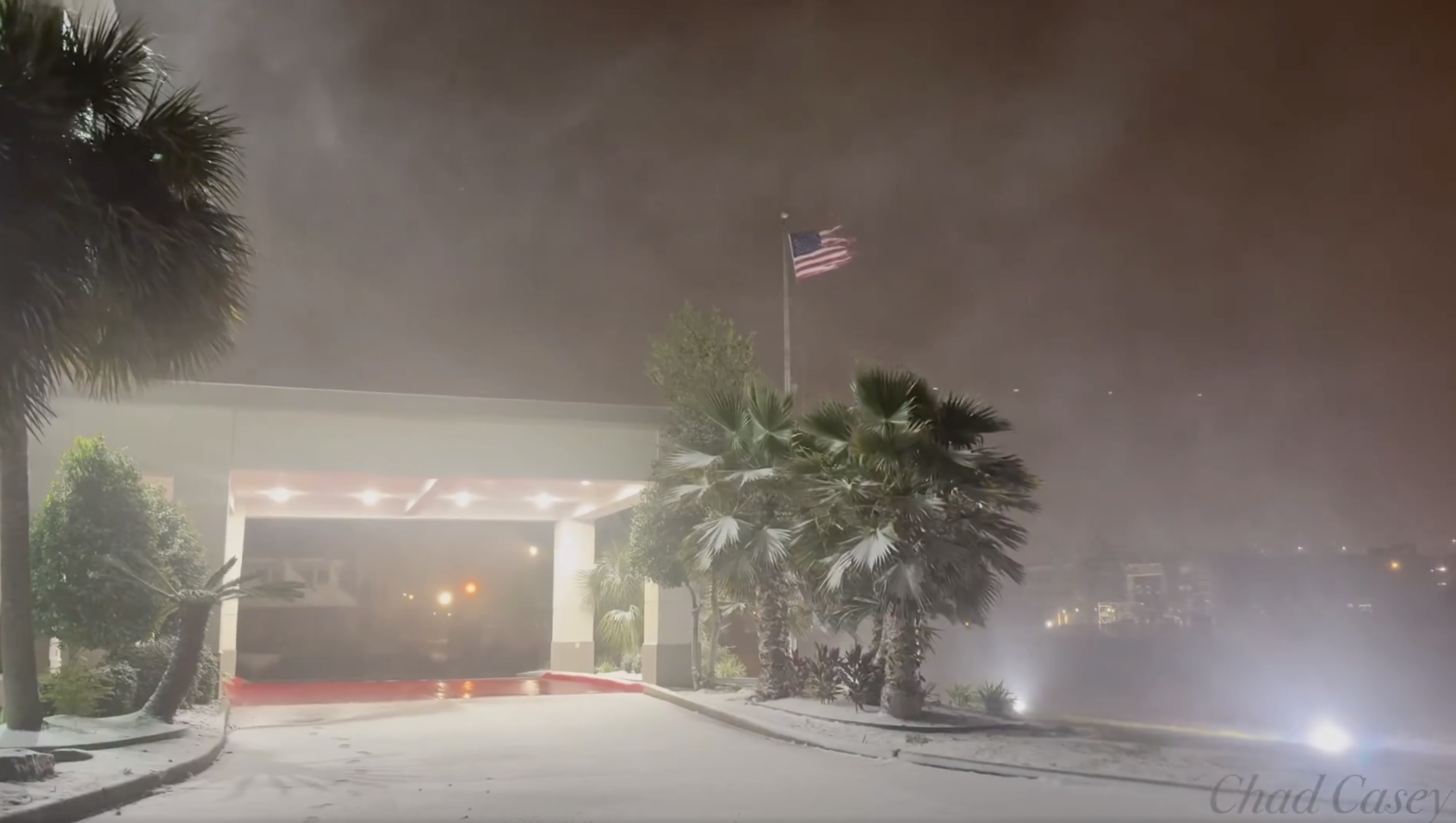
The Final Word: Gulf Coast Snow Update: Revised Snowfall Totals, More News

You'll never see this again. A view Tuesday in
New Orleans, Louisiana. 
The weird, once in a lifetime snow is quickly melting away along the Gulf Coast, and the pace of the thaw will pick up in the coming days as more normal weather returns.  

The snow was obviously an incredible novelty, but there is of course sad news associated with it. At least 11 deaths have been attributed to the snow and accompanying cold snap. 

Us weather geeks are still amazed as snow totals are finalized. If anything, some of them have been revised upward. 

The total in the Florida towns of Milton and Jay are now set at 10 inches even,  more than double the old record for the biggest snowstorm on record for the entire state. 

Grand Coteau, Louisiana reported 13.4 inches, and may have been the snowiest place in the United States Tuesday. It's possible one or two towns near the Great Lakes had more in lake effect snow, but that's uncertain. 

Babbie, Alabama reported 11 inches.  The eight inches in New Orleans was confirmed as a record, as was the 9 inches in Lafayette, Louisiana. 

Mobile, Alabama had a record snowfall of 7.5 inches. 

Skies cleared Tuesday night in places along the Gulf Coast from about Mobile westward.  Clear skies, relatively light winds and a snow cover almost always cause remarkably low temperatures. 

Acadiana, Louisiana reached 2 degrees above zero, for an all-time record low. The town is just 30 miles from the Gulf of Mexico. 

Two locations a little outside of Lafayette got down to 1 below.   That was about the same as Burlington, Vermont, which got down to 2 below that morning. 

Lafayette itself had an all time record low of 4 above. That was a full 14 degrees colder than the old record for the date and an incredible 40 degrees below the normal low for the dates.

Lake Charles bottomed out at 6 degrees. 

Mobile had record low of 6 above.  Only the great cold wave of 1899 was worse, as it got to minus one on that occasion. 

The only way to build a snowman or snow woman
in New Orleans. Photo via Fox Weather 
reporter Brandy Campbell. 

The strength of this cold wave was not the most intense ever along the Gulf Coast. But never before were there several inches of snow on the ground under mostly clear skies during a cold snap near the beaches.

The result was all-time record lows, not even seen back in the day - 1800s to 1930s when they began keeping records in a world that had not experience global warming yet due to our fossil fuel consumption.  

It proves that under the right conditions - which happened in this case - you can get incredible frigid spells. Just not as frequently as we once had. 

Obviously, road travel was nearly impossible along the Gulf Coast with the snow. 

But oddly, at least to me, it was Atlanta that suffered the most chaos from the storm.  They didn't get all that much snow, at least compared to cities closer to the coast. 

Also, though Atlanta isn't particularly used to or well equipped for winter storms, such weather isn't exactly unheard of there. 

The Atlanta area only got an inch or two of snow Tuesday. But it hit in the afternoon.  The snow initially melted on many roads then froze into a solid, slick sheet of ice.  People were stranded on highways overnight and at least hundreds of cars slid off roads. It was a mess. 

The storm that caused all this moved off the southeast coast Tuesday night and began an incredibly fast race across the Atlantic Ocean. It also strengthened mightily to become Storm Eowyn, which is expected to be one of the worst windstorms on record for Ireland and Scotland. 

While all this was going on and not to be outdone, while the South was blizzardy, so too, was the more traditional snow belts along near the Great Lakes this week.  Over three days ending Wednesday morning, Adams and Barnes Corners, New York each reported 40 inches of new snow. 

VIDEOS:

Who knew? Turns out people in New Orleans are really good at building snowmen, despite their lack of experience with winter weather. Check out some examples. Click on this link to view, or if you see the image below, click on that. 


Tourists are drawn to the white sand beaches along the Gulf Coast in Florida.  A once in a life time experience was the new, white snow beaches there. Click on this link to view or if you see image below, click on that. 


Practically everyone in the Deep South got outside to enjoy the snow, including these nuns in a snowball fight in Metairie, Louisiana. Again, click on the link to view or if you see the image below, click on that. 


Another big snowball fight, this one in, (checks notes) Jackson Square, New Orleans. One more time, click on this link to view or if the image is visible below, click on that. 


Wednesday, January 22, 2025

Gobsmacked By Incredible Gulf Coast Snow; Dangerous, All-Time Record Cold This Morning, Travel Paralyzed In Region.

Screen grab of web cam showing snowball fights and
dogs playing on snowy Bourbon Street, New Orleans.
The incredible snowstorm that hit the Gulf Coast Tuesday is easily one of the most incredible weather events I've ever seen. 

Snowfall records were shattered as near blizzard conditions swept what are normally balmy, palm tree-lined beaches. 

New Orleans was buried beneath an official eight inches of snow, its largest snowstorm on record. Some sections of the city had more. Photos of a measurement in New Orleans' Garden District showed a solid foot of new snow. 

The Washington Post was as gobsmacked as I was when I saw these weather observations out of New Orleans.   

"A late morning observation from Louis Armstrong New Orleans International Airport reported a temperature of 27 degrees, heavy snow, 1/8 mile visibility - and three inches of snow on the ground. Two inches fell in one hour."

For at least seven consecutive hours heavy snow fell on New Orleans.

I saw one video showing a highway with zero visibility in snow and blowing snow.  I thought I was watching one of those lake effect blizzards in Buffalo. It was a highway in southwest Louisiana.  

Milton, Florida, not far from Pensacola, had 8.8 inches of snow, more than doubling the old record for largest snowstorm in Florida history. (The old record was four inches, also set in Milton). Pensacola, Florida and Baton Rouge, Louisiana each had 7.6 inches.  Mobile, Alabama clocked in with 7.5 inches. 

These shattered all-time records for snowfall in those cities. 

For comparison, the 24 hour snowfall in Milton, Florida of 8.8 inches is much more than double   the largest 24-hour snowfall in Milton, Vermont so far this winter, which was just 3.4 inches. 

Many northern parts of the United States have had less snow this winter than parts of the Gulf Coast, which is insane. 

Sioux Falls, South Dakota has had 6.2 inches of snow this entire winter so far, less than many Gulf Coast beach towns. Since December 1, Anchorage, Alaska has had 3.8 inches of snow (though to be fair, Anchorage did have some hefty snowfalls in late October)

DANGEROUS AFTERMATH

The Gulf Coast and Southeast snow zone is massive, running through most of the Texas coast, all the way through northern Florida and up into coastal Georgia and South and North Carolina. 

Somebody's Florida vacation photo
from Tuesday. 

The storm was departing and the last of the snow was departing the Southeast Coast, but the Gulf Coast is not out of trouble.

Tuesday was the fun day for most, as big and festive snowball fights broke out on Bourbon Street in New Orleans. Airboats that normally cruise through marshlands were pressed into service as snowmobiles. 

Families marveled at a snowstorm that they've never seen before and probably never will again unless they move north. 

But all that snow is now sitting there.  You can't drive anywhere. The Gulf Coast has elaborate and detailed emergency plans on what to do if a hurricane hits. Not so much with a snowstorm. 

It's obviously seriously cold on the Gulf Coast, and they're not equipped to handle it. What if there's a fire or medical emergency? How will ambulances and fire trucks get to the scene?

As of last night, a 150-mile stretch of Interstate 10 was closed. New Orleans borrowed 14 snow plows from an Indiana company.  Bucket loaders that normally shove sand off roads after hurricane storm surges were also pressed into service as snow plows in the region. 

The snow is not going to immediately melt much.  The forecast high temperature today in New Orleans today is 31 degrees. Clear skies, lighter winds and a snow covered ground brought the temperature in Mobile, Alabama down to a record-shattering 11 degrees this morning, with an expected "high" temperature today of 32 degrees. 

Even more extreme, Lake Charles, in southwestern Louisiana was down to just 6 degrees above zero this morning.  The previous record low for the date there was 18 degrees, so that's just incredible for them. 

Lafayette, Louisiana, where nine inches of snow fell yesterday, was at just 4 degrees above zero early this morning.  That is the coldest temperature on record for any date in Lafayette. New Iberia, Louisiana also set its all-time record low temperature at 3 degrees. So far, Beaumont, Texas has tied its all time low at 10 degrees. 

That's what a clear night sky with snow cover will do to you. That's never happened before in these cities, hence the extreme cold. 

Already, four deaths have been reported in the cold wave and snow, and I'm afraid that toll will rise. 

Temperatures are forecast to rise into the low to mid 40s across the Gulf Coast Thursday and Friday, which will melt some of the snow. But streets will still be in rough shape with overnight freezes.

Finally, temperatures this weekend will be back in the normal upper 50s and 60s, which should make the last of the snow disappear. 

WHY IT HAPPENED

You really need an exacting setup for this kind of weather event and it just so happened this time. 

Big Arctic cold blasts come all the way down to the Gulf Coast from time to time. But usually. that frigid air crosses the coastline and enters well into the Gulf of Mexico. Any storms that try to form on the leading edge of the cold air usually are too far south to bring any kind of precipitation to places like New Orleans.

Or, the cold air stops just short of the Gulf Coast, so it's warm enough for rain, not snow. 

This time, the leading edge of the frigid air stopped a short distance south of the Gulf Coast. As is often the case, a storm formed along the leading edge of the cold.  The storm pumped humid air northward over the frigid air near the surface in just perfect alignment with the coastline. 

The best moisture aloft and the best cold, moist air along the coast aligned perfectly to set up the snow. 

I won't blame climate change for this.  It was all probably a fluke. But some scientists say climate change does make the jet stream meander more, which can sometimes bring cold air oddly south, like in this case.  

Also, the Gulf of Mexico waters are still unusually warm, which can be blamed on climate change. The warmer waters probably boosted the amount of moisture available to the storm, which increased the amount of snow that could fall. 

Videos:

Blowing and drifting snow on the beaches of Louisiana and Texas, along with road havoc in the region. Click on this link to view, or if you see the image below click on that. 


The music doesn't stop in New Orleans just because it snows. Here's a trumpet player in the city's blizzard. Click on this link to view, or if you see the image below, click on that. 


Tuesday, January 21, 2025

An Absolutely Bonkers Winter Storm Is Striking Gulf Coast. Blizzard Warning In Coastal Louisiana!

Screen grab of video showing strong winds, snow and
blowing snow early today in Lake Charles, Louisiana,
which is, of all things under a blizzard warning.
 The National Weather Service home page weather map had things today I don't think I've ever seen before. 

Winter storm warnings are up from far southern Texas all the way across the entire Gulf Coast to the Big Bend area of Florida. Forecasts for the winter storm intensity have gone way up since I first reported on this storm on Sunday.

A blizzard warning, of all things, is in effect right along the Gulf Coast in extreme northeastern Texas and southwestern Louisiana, including the cities of Port Arthur and Lake Charles.

I'm certainly used to seeing tropical hurricanes come ashore in this area, but a blizzard?

The criteria for a blizzard warning in the Deep South is different than for places like, say, North Dakota, but this is still impressive. 

The Louisiana blizzard zone is getting bands of heavy snow and blowing snow with gusts of at least 35 mph, so that's an impressive winter storm. Total snowfall will run the four to eight inch range in that area today.

The area under the blizzard warning normally has a high temperature in the low to mid 60s this time of year with lows in 40s. It would be like Vermont having a full-blown blizzard in mid-May. 

We'll have plenty of for-examples of how bizarre this has gotten on the Gulf Coast today. I'm already seeing a few. 

Port Isabel, Texas, a near-tropical city along the southern Texas Gulf Coast right on the border with Mexico early this morning, had arguably worse winter weather than we're currently having in Vermont. At 5 a.m. it was 36 degrees, light snow with north winds of 36 gusting to 52 mph and a wind chill of 22 degrees. 

Normally, this time of year, Port Isabel has highs in the upper 60s and lows in the mid 50s. 

A wild National Weather Service home page this morning.
All that pink you see on the Gulf Coast is
all winter storm warnings 
Five or six inches of snow is forecast for New Orleans. That would make it easily the biggest snowstorm there since eight inches fell in February, 1895. The modern record for deepest snow in New Orleans is 2.7 inches in December, 1963. 

Pensacola, on Florida's Panhandle near the Alabama border, is anticipating two to four inches of snow today, with the possibility of five inches. The biggest snowstorm on record in Florida is four inches, so we might be rewriting history here.  

Winter storm warnings in Florida extend as far south as Gainesville, where freezing rain, sleet and snow could collapse trees and power lines. 

The winter storm is expected to continue today and tomorrow on up the coastlines of Georgia, South Carolina and North Carolina

DANGEROUS

This winter storm is obviously quite the novelty, but it's extremely dangerous. 

To be Captain Obvious here, the Gulf Coast isn't built for winter storms. They're much better at handling full-fledged hurricanes than this type of weather. 

The six inches or more of snow that could fall in Louisiana could collapse roofs, since they're not built for snow loads like they are here in New England. 

The Deep South isn't used to such cold weather, either.  Pipes aren't insulated, so they'll freeze.  The epic freeze in Texas in February, 2021 caused billions of dollars in damage as frozen pipes burst, flooding homes, condos and commercial buildings. 

Snow on the ground makes frigid nights even colder. A snow-covered Deep South could end up with record temperatures in the single numbers and teens tonight or tomorrow night. 

Travel is - or will soon be - impossible in the Gulf Coast winter storm zone. It's not exactly like they have armies of snow plows and sanders to clear the roads. People there also understandably have no clue how to drive in the snow.

As of the pre-dawn hours, Houston freeways were already an icy disaster and parts of Interstate 10 in Louisiana were already closed. 

Airports are shutting down in the region, too.

The governors of Florida, Georgia, Louisiana, Mississippi and Alabama have all declared states of emergency because of this weird storm.  

The silver lining to this storm is the weather along the Gulf of Mexico should return to normal by the end of the week. Which is good, because they'll have to wait for the snow and ice to melt before anything can be done about the situation. 

Daytime temperatures should rise into the 40s by Wednesday. By Sunday, New Orleans expects a high temperature of 65, Houston should get to 68, and Pensacola is anticipating a Sunday high of 62.

Sunday, January 19, 2025

Rare Southern Winter Storm Set To Strike As Far South As Gulf Coast, Florida

Fox Weather has this extraordinary snow forecast
map for the Gulf Coast. Lots of snow for places
that far south. Could be a couple record snowfalls.
The Northeast is gearing up for a winter storm later today, as I noted this morning. 

But that part of the nation is used to that sort of thing in January. The real winter news is going on along the Gulf Coast of all places.  

Meanwhile, though, there are separate winter storm watches in effect in decidedly non-Arctic cities like Galveston, Houston, New Orleans, Baton Rouge, Mobile and Pensacola. 

Yeah, this is a weird one. Chances are you'll see lots of photos of palm trees dusted with snow. 

Those winter storm alerts actually cover most of the Gulf Coast and Deep South.   Those watches extend through southern and central Texas,  most of the southern halves of Mississippi and Alabama, and even the western tip of the Florida Panhandle. 

Eventually the storm is forecast to reach the coastal Carolinas. 

Baton Rouge could see three to five inches of snow out of this. New Orleans is possibly in line for one to three inches. 

Parts of far eastern Texas and central Louisiana are expecting up to eight inches of snow.

A bit of snow or ice could mix in with rain Tuesday night even in Tallahassee and Jacksonville, Florida. 

Winter storms happen from time to time in the Deep South. There was just one last week. But those winter conditions usually don't extend southward to Interstate 10, which hugs the Gulf Coast from Florida to Houston. 

This time, however, it looks like it might just happen. 

This kind of thing can obviously be dangerous in areas that aren't used to snow.  There's the obvious travel problems, since the Gulf Coast isn't exactly ready with snow plows and salt truck like they are up here in Vermont.

The 5 to 8 inches of snow expected in central and western Louisiana could collapse flat roofs and awnings, since such structures aren't built for snow loads in that area. Trees could collapse under the weight of the snow and ice too. 

The cause, of course, is that Arctic blast roaring down from Canada. It's making it all the way to the Gulf Coast.

Storms often form on the southern and eastern edges of these frigid air outbreaks. That's why there's a storm on the leading edge of the cold air on the East Coast today. 

This bitter air is running into the warm waters of the northern Gulf of Mexico, so a storm is forming there. The storm will force balmy air from the Gulf to try and ride up and over the cold, dense air along the coast. 

There, the risk is freezing rain and sleet. But inland just a bit, the cold air will be thick enough so the precipitation will start out as snow and make it all the down to the ground as those flakes. 

Usually this kind of thing sets up a little further north, but this time, it's further south than usual. This could be a record breaker or near record breaker in some areas. 

GULF COAST SNOW RECORDS

 New Orleans has not seen measurable snow in 15 years

The biggest snowstorm in New Orleans history came on Valentine's Day, 1895, when eight inches accumulated. That same storm dumped an incredible 22 inches of snow on Houston, Texas and Lake Charles, Louisiana, and 12.5 inches on Baton Rouge 

At least something like that won't happen this time.  

In modern history, the biggest snowstorm in New Orleans was 2.7 inches on December 31, 1963. There is a chance they could get that much in this week's storm. 

Baton Rouge has a shot at receiving its biggest snowstorm in the past 100 years, too. The had six inches in February, 1940. The next biggest snowstorms were 3.5 inches on January 23, 1940 and December 8, 2017.

Florida's biggest snowstorm that I could find was four inches in the town of Milton, a little northeast of Pensacola on March 6, 1954. There is a very low, but not zero chance of that much snow falling in the northwest corner of Florida this week.   

In December, 1989 three inches was reported at two northern Florida cities and 2.5 inches fell that day at Jacksonville, Beach 

Tuesday, September 24, 2024

Soon To Be Hurricane Helene Big Threat To Florida, Gulf Coast, Southeast

This is one computer model's version of what
soon to be Hurricane Helene might look like off
the west coast of Florida Thursday morning.
This model takes the storm northward to hit
Florida's Big Bend, where the panhandle curves
to start forming the main Florida peninsula. 
UPDATE 1 PM Tuesday.

As expected, the system has been upgraded to Tropical Storm Helene as of 11 a.m today.

The forecast for it hasn't changed much since this morning. 

It should be a hurricane by sometime tomorrow morning as it begins to move northward into the Gulf of Mexico.

The only question now is how big it will get, how strong it will get and how much it maintains its strength by the time it hits land, probably in northwest Florida later Thursday.

Stay tuned!

PREVIOUS DISCUSSION 

What will become Hurricane Helene is now a big threat to the United States Gulf Coast, especially Florida this week.   

Early this morning, what will almost surely be Hurricane Helene within the next couple of days was still something of a disorganized mess in the northwestern Caribbean Sea. 

 It hadn't formed a well-defined center yet, so before dawn it was still awkwardly called Potential Tropical Cyclone Nine.

As I wrote this post early today, hurricane hunter planes were invading the developing storm, poking and prodding it for clues as to what it will do and when.

Even before those hurricane hunters went in today, forecasters have a pretty good broad brush idea on wannabe Helene's growing danger. 

This was already a large area of stormy weather. Upper level winds, which were slightly hindering development, should quit today. The stage is set for this thing to quickly turn into a monster.

Steering currents in the atmosphere should take the developing system northward and a quickening pace.

The National Hurricane Center expects the growing storm to squeeze itself between Mexico's Yucatan Peninsula and western Cuba tomorrow morning and early afternoon so that it ends up in the Gulf of Mexico.

Even if the center of the storm clips Cancun or western Cuba, that would only very briefly disrupt its growth. It'll have plenty of resources to strengthen as it approaches the eastern Gulf Coast. 

The gulf waters are extremely warm, at near record levels. There's the jet fuel for a growing hurricane.  Upper level winds at this point shouldn't hinder its growth much, if at all. The fear is what is now Wannabe Helene will become major Hurricane Helene by the time it comes ashore Thursday night. 

"The potential for life-threatening storm surge and damaging hurricane force winds along the coast of the Florida Panhandle and the Florida west coast is increasing," the National Hurricane Center said last evening. 

Dawn breaking this morning on what will be Hurricane
Helene. Looks disorganized now, but those hot white 
clouds are the thunderstorms that should fuel
it's fast development today and tomorrow.

It's looking like Helene will be large, covering a big area. That would make problems like storm surges and high winds worse and more widespread than if this was a more compact storm. 

Helene would be the fifth hurricane to hit Florida since 2022, so that state has really been battered lately. This won't help.

That a major hurricane seems likely in Florida in just over 48 hours doesn't give people a lot of time to prepare. Florida Gov. Ron DeSantis has declared a state of emergency in 41 counties and the state has activated its price gouging hotline.

They're trying to prevent retailers from upping prices on necessary supplies that people are rushing to buy ahead of the storm. 

I'm sure we'll hear news of evacuations from coastal parts of Florida later today. 

Although forecasters are confident Helene will end up being a pretty strong hurricane and it's most likely to hit land in northwestern Florida, there are picky little details that could change things. Or at least clarify things in the next couple of days before landfall.

Anyone from Biloxi, Mississippi eastward through Florida should be nervous. It could also trend further east and hit western Florida. It would be particularly bad if it comes ashore near Tampa, as the hurricane would shove an incredible amount of destructive storm surge into Tampa Bay. 

There's also questions of how strong this will be. It seems very likely that at landfall, wannabe Helene would have top winds of at least 115 mph with a storm surge of eight feet.

Worst case scenario would be if this thing ends up being like Hurricane Michael in 2018.  That one kept strengthening to a category 5 with top winds of 160 mph when it hit shore a little east of Panama City, Florida. 

INLAND THREAT

As all hurricanes do, what will be Helene's intense winds will quickly diminish right after it comes ashore.  However, Helene's fast forward speed would allow strong winds to punch pretty far inland to cause damage well away from the coast.

It kind of reminds me a little of Hurricane Hugo in 1989. It hit Charleston, South Carolina and surroundings with devastating force. It was moving so quickly forward that Hugo still managed to cause highly destructive winds around Charlotte, North Carolina, which is a good 200 miles inland.  

The remains of Hugo even managed to produce winds strong enough to produce  quite a few power outages here in Vermont. I remember an odd scene it created around midnight at Burlington's north beach. Hot air brought to Vermont made temperatures that night soar to 80 degrees. We bodysurfed in three to four foot waves generated by the winds as power flashes lit up the sky here and there as trees fell onto electrical lines.

I bring that up just to demonstrate how hurricanes can cause weird and damaging effects far from their landfall spot.

Anyway, an upper level low in the Mid-South seems likely to capture the dying hurricane and spread large areas of torrential rains over swaths of the Southeast. At this point, it looks like the southern Appalachians are most under the gun for serious flooding late this week and the weekend, though that forecast could change a bit. 

VERMONT EFFECTS

Unlike Hurricane Hugo in 1989, it's starting to look like Helene won't bother us much here in Vermont, if at all.

Strong high pressure, mostly centered over southeast Canada, has blocked any kind of real storminess from reaching the Green Mountain State since around September 8.

The high pressure will temporarily withdraw somewhat for the next couple of days, allowing some needed rain to move into the Green Mountain State tomorrow and Thursday. This rain is completely unrelated to Helene, and will not be especially heavy.

Then, that persistent high pressure will reassert itself, once again acting as roadblock preventing the remains of Helene from pestering us. 

We've already had two former hurricanes - Beryl and Debby - cause quite a bit of havoc in Vermont this year, so it's nice that - fingers crossed! - Helene will leave us completely alone. 

Tuesday, May 14, 2024

Vermont Still Showery, Locally Stormy As Gulf Coast Keeps Getting Blown Away, Drowned

Sun, clouds, sprinkles and TONS of black flies. That
was the way it was in my St. Albans, Vermont
yard on Monday evening. It rained again later at night. 
UPDATE: 1 PM

It turns out some of the storms that do manage to form in northern and central Vermont could be a little rambunctious this afternoon and early evening.

There seems to be enough instability out there so that a small minority of the the thunderstorms could contain strong, gusty winds and torrential rain, 

NOAA's Storm Prediction Center has put much of northern New York and northern New England, including the upper half of Vermont, under a marginal risk of severe storms. 

That's the lowest of a five point alert scale and indicates one per two towns in that alert zone could get a severe storm with damaging winds.

The vast majority of us should just see standard issue showers and thunderstorms this afternoon. Do note that lightning is always dangerous even if the parent storm isn't extreme, so head indoors if you hear thunder. 

The best chances of strong to severe storms are just south of where skies have cleared. I would put that give or take near Route 2. 

PREVIOUS DISCUSSION

It's a rinse and repeat kinda day here in Vermont as more rounds of showers and maybe a rumble of thunder roll through once again. 

In once sense it's a typical May in the Green Mountain State, as temperatures have hovered fairly close to normal all month so far. Showers have been frequent, too, which is a pretty average state of affairs here.

On the other hands, it's been abnormal, too.  We usually get well defined spells of showery weather with periods of brilliant blue skies in between. Lately, those completely clear skies have been hard to come by. 

Sure, we've had nice enough days and maybe only a day or two has been a washout, but dawn to dusk sunshine has been non-existent since April 26.

Another weird thing is, despite all the showers, the month of May so far is actually a bit drier than average, at least in northern Vermont. Those showers have been on the light side. 

Through Monday. Burlington has collected 0.83 inches of rain, which is two-thirds of an inch on the light side for the month to date. Montpelier had an inch of rain this month through Monday, which is a third of an inch on the light side.  

Even with the slight lack of rain in the north, we are far, far, far from any drought worries. 

Southern Vermont has been doing better. Rutland and Bennington is running above average for rainfall so far this month. 

More showers are filling rain gauges a bit today. As far as heavier rain goes, it will be hit and miss. The showers today are riding roughly west to east along and a little south of a stalled front over southern Quebec. 

The few of us that get hit by two or three downpours will have a soaker. The rest of us, wet, but meh. 

The front will slowly sink southward today, giving almost everybody in the Green Mountain State an opportunity for showers, and maybe a rumble of thunder.  It'll get pretty warm in the south, as it will take awhile for the front to approach that area. A few spots in valleys along and south of Route 4 could make it to 80 degree today.  

Meanwhile, areas near the Canadian border will barely make it to 70.

For the rest of the week, through the weekend and probably into next week, this state of affairs will continue, with almost daily shower chances, and no extended periods of sunny weather in sight. Also, day long washout rains are also pretty unlikely. 

GULF COAST AWFULNESS

At least the showers and storms in Vermont have been gentle garden variety stuff. The Gulf Coast has been pummeled by repeated bouts of severe weather all spring. Over the past couple of weeks, it's only gotten worse.

Wave and wave of storms since last week have traveled from Texas through the Gulf Coast States to Florida. 

The storms caused intense flooding last week north of Houston after more than a foot of rain fell in those areas. Hundreds of people had to be rescued, including some from rooftops of inundated homes. 

Storms lashed the South again Friday, unleashing tornadoes and high winds. Tornadoes were especially destructive around Tallahassee, Florida and in parts of Alabama.

Fresh waves of intense storms again hit the zone from the Texas Gulf Coast to Florida again Monday, hitting Louisiana especially hard. A tornado touched down in Sulfur, Louisiana, and winds gusted to 80 mph in Lafayette. At least two people died in Monday's storms. 

Flash flooding was pretty widespread, too.

No rest for the weary down there, either. A new outbreak of severe storms and tornadoes seems likely Thursday and Friday. 

In areas hit by the most intense flooding, including parts of Texas and Louisiana where some rivers are still at major flood stage, torrential rains are set to hit by Thursday. Up to 10 inches of rain, locally more, are in the forecast there over the next seven days.  

Though severe storms and flooding often hit the Gulf Coast this time of year, it's very odd for the storms to be so persistent. 


Tuesday, March 29, 2022

Wildfires And Severe Storms This Week Are Following Concerning Trends

Wildfires just keep getting worse in the central and 
southern Great Plains. Fire activity is forecast to get
intense later today. 
 Northern Texas, western Oklahoma and southwestern Kansas are under a rare alert for "extremely critical fire conditions" today as yet another round of wildfires are bursting their way through the central and southern Plains. 

Meanwhile, the Gulf Coast states are gearing up for a big severe thunderstorm and tornado threat tomorrow. Both of these issues are part of a worrying trend. 

WILDFIRES

Extremely critical fire condition alerts are usually only issued 10 or so days per year somewhere in the nation.  This is the second time already this year that parts of Texas have been under this threat. This threat level means that dry conditions, very low humidity and strong winds would make any wildfires that start pretty much impossible to contain. 

In the "extremely critical" area today, fires were already spreading before weather conditions were expected to get dangerous. By dangerous, we mean a landscape parched by drought, bone-dry humidity and winds of 35 to 40 mph with gusts in the 65 to 70 mph range 

As of this past Friday, 123,000 acres in Texas had already burned this month, more than the three previous Marches combined, according to Texas Tribune.

The Texas fires this year have already caused one death and burned several structures.

Fires are already burning today in Oklahoma as well. A grass fire that started at an Oklahoma City salvage yard threatened several homes in the city. At least 10 of the houses were evacuated, but it looks like firefighters managed to save them. 

Earlier this month, a firefighter died while fighting a rangeland blaze elsewhere in Oklahoma. Several other wildfires this month have raced through mostly open country in North Texas, Oklahoma and Kansas. 

As is so often the case, climate change seems to be helping to create an increasing trend of winter and spring wildfires in the Great Plains. Drought has become more endemic, and hotter weather than in the past dries things out faster. 

This has been known since at least 2017, when a study indicated that the number of large and dangerous wildfires in the Plains tripled between 1985 and 2014. 

It isn't just climate change causing this, of course. Farm abandonment is one reason.  If farmland is left alone, flammable weeds take over. Also, invasive species like a variety of cedar that burns easily and hot are probably increasing the severity of at least some of the fires.

TORNADOES

Notwithstanding last week's storms in Texas, there's been a trend toward lower numbers of tornadoes in the traditional "Tornado Alley" in the Great Plains.  The new tornado alley, if you will, now seems to be further east, in the Gulf Coast States, and the Mid-Mississippi and Tennessee River valleys. 

Once again, the Gulf Coast states are under a serious
risk of damaging thunderstorms and tornadoes, 
with most of them happening tomorrow. 

True to form, after a chance of a few tornadoes and severe storms today in a band from northeast Texas to southwest Iowa, tomorrow looks dangerous again in the Gulf Coast states. 

If things work out as expected the outbreak of severe storms and tornadoes centered in and around Mississippi won't be those classic individual supercell storms dropping large, wedged-shaped tornadoes.

Instead, most of the rough weather will consist of an intense line of storms, with damaging straight line winds of 75 mph in a few spots, along with embedded tornadoes swirling within the main line. In some ways, this type of tornado is more dangerous than "traditional" tornadoes with well defined funnels.

Tomorrow's anticipated tornadoes will be quick hitting and hidden behind walls of heavy rain, so nobody will be able to see them coming. Even though radar will pick up the tornadoes and the National Weather Service will issue tornado warnings as needed, there's something about human nature that needs visual confirmation that the twister is heading toward them.  There will be no such visual confirmation in most cases tomorrow. 

Research has confirmed the tendency in recent decades of more tornadoes in "Dixie Alley" and fewer overall in the Great Plains. 

The number of times the atmosphere is conducive to tornado formation is actually increasing pretty much everywhere east of the Mississippi River, including here in Vermont. (But don't worry too much, tornadoes will remain rarity in the Green Mountain State. 


Thursday, August 26, 2021

One More Awfully Hot Day In Vermont; Hurricane Threat In Gulf?

Another tropical dawn today over St. Albans, Vermont.
It's almost September, so the heat and humidity will
have to disappear at some point, right?
UPDATE: 4:00 pm. THURSDAY

Heat indexes, as expected, are in the upper 90s this afternoon in the Champlain Valley of Vermont. So it's awful. Actual temperatures are in the low 90s in the Champlain Valley, and in the upper 80s elsewhere

On the bright side, this will very, very likely be the hottest day until next summer. 

As expected, thunderstorms are few and far between this afternoon. A layer of warm air overhead is preventing the tall clouds you need for thunderstorms to really take off

Every once in awhile, thunderstorms can break that "cap" and really develop. So the rest of the day and evening in Vermont will feature few thunderstorms, but a few of the ones that do develop could get strong very quickly. One such storm abruptly developed northeast of Middlebury at mid afternoon, and it was probably causing a pocket of gusty winds and torrential downpours.

The few storms that are forming aren't moving forward all that fast, so there could be small pockets of flash flooding with these. 

That disturbance in the Caribbean I mentioned this morning has developed into a tropical depression, and will grow into a tropical storm pretty much any minute from now. It still looks like a very bad threat to somewhere on the U.S Gulf Coast by around Sunday. 

More on that in tomorrow's post

PREVIOUS DISCUSSION
 
As noted yesterday, it's been awfully hot and humid in Vermont for over a week now, and today will offer absolutely no relief. Unless you count an isolated thunderstorm or two, which will only add to the humidity.  

There is still a cold front in the schedule, though, and you'll really feel the difference tomorrow. 

Yesterday actually felt a little better than it has been lately because, despite temperatures that reached 90 in some spots, a bit of drier air was able to mix down from aloft during the afternoon.

Dew points went into the low 60s, which is still a little humid, but not nearly as bad as dew points of near 70, which has been the case lately.

Unfortunately, the dew points are back up, and there's no drier air a few thousand feet above us to mix down when the sun shines strongly this afternoon.  Heat advisories are up for the broader valleys of Vermont today, as it'll feel like its in the mid or upper 90s. 

The actual temperatures will be well into the 80s to near 90.  If Burlington makes it to 90 today, we'll have an official heat wave, meaning three days in a row will have gotten to 90 degrees or more. 

Because there is a cold front lurking to our north, there will be enough instability to fire off some thunderstorms this afternoon.  It's not an ideal set up for storms, so there will be hit and miss, mostly miss.

A few spots could get torrential downpours but a lot of places will get nothing, or at least very little rain.

You'll go to bed tonight in yet another muggy, icky evening, but changes will be afoot as you try to sleep.

That cold front will slip down from Canada in the pre-dawn hours with little fanfare.   Especially in northern Vermont, you'll notice a change in the air when you wake up, and that relief will fully engulf the state during the day. It will feel awesome. Sunny, breezy, much cooler and the long period of high humidity will be gone at last.

Or will it?

First the bad news. It's going to quickly get wicked humid again.  You might notice it a little later Saturday and it will get worse Sunday and even more awful Monday.

Then the good news. The next bout of oppressive weather won't last so long.  As it stands now, the humidity will get whisked away by another cold front or cold fronts. 

Also, we're needing the rain again in northern Vermont.  The weekend and early next week look unsettled, on top of all that humidity. That means there will be a good chance of on and off showers Saturday through Monday.

HURRICANE FEARS

As of this writing early this Thursday morning, there were not full-blown tropical storms or hurricanes anywhere in the Atlantic Ocean, but that seems destined to change and soon.

I usually don't like to hype a big storm before it forms and before I think I know where it's going.

However, there's so much agreement among the computer models that a hurricane is targeting the Gulf of Mexico and possibly the U.S. Gulf Coast that I have to say something.  There was a disturbance south of Jamaica this morning that was getting better organized, and pretty quickly at that.

It's expected to move northwest toward the Gulf of Mexico.  It also appears as if atmospheric conditions are ripe enough to organize this thing into a tropical storm, then probably a hurricane. 

The water in the Gulf of Mexico is pretty much as hot as it can get.  Hot water is jet fuel for hurricanes, so if there is not much in the way of strong upper level winds to tear a nascent hurricane apart, there's a chance this thing could turn into a monster.

We don't know where this possible hurricane will make landfall, but Texas and Louisiana could well be under the gun. 

Some of the models bring this wannabe hurricane into southwestern Louisiana as a powerhouse. Which would be incredibly bad since that region was devastated by Hurricanes Laura and Delta last year. Plus that region's health care network is next to collapsing under the weight of surging coronavirus cases.

A big weather disaster would just be beyond awful.

Since this wannabe hurricane hasn't even formed yet, big changes are coming in the forecast for this thing? Will it interact with land and weaken as a result?  Will it take full advantage of the hot water in the Gulf of Mexico and turn into something particularly dangerous?  Where will it hit land? At this stage, it could be Mexico, Texas, Louisiana, Mississippi or Alabama.

Stay tuned.

Wednesday, October 28, 2020

Hurricane Zeta To Slam Gulf Coast Today

Hurricane Zeta this morning looking healthy and
targeting Louisiana and Mississippi 
 It wouldn't be the year 2020 without yet another hurricane over performing and getting ready to wreck another part of the United States Gulf Coast.  

Hurricane Zeta strengthened pretty robustly last night, and was packing highest sustained winds of 90 mph on approach to the Gulf Coast early this morning. 

Zeta has a shot at strengthening a bit more before cooler coastal waters, stronger upper level winds and proximity to the coast shut off the fuel that keeps letting Zeta becoming muscular. 

So, Louisiana, Mississippi, and Alabama are in for a big blow later today and this evening. 

Forecasters have upped the predicted storm surge to as much as six to nine feet above normal sea level.  

Zeta's forward speed is faster than the usual Gulf of Mexico hurricane, so that will help winds be stronger on the eastern side of the storm.  That's because on the eastern side of a northbound storm, you have to add the winds of the storm with the forward speed to get what actually  happens.

The fast forward speed means that winds will continue to blow strong and damaging well inland, because Zeta won't have time to weaken much once it moves inland, since it's moving so fast. A tropical storm watch is in effect as far inland as the Atlanta, Georgia area.

The only bright side is the forward speed is so fast that epic inland flooding is probably not in the cards. The storm won't have time to dump huge amounts of rain. 

However, hurricane rains are torrential, so some flooding is inevitable. On top of that, as Zeta dies inland, it will merge with another storm to create a soaking, potentially flooding rain in parts of the Deep South, Tennessee Valley and Mid-Atlantic States.

This will be the fifth hurricane to strike the Gulf Coast and third time a hurricane has struck Louisiana this year, so I'm sure everybody has had enough by now. 

It'll be the latest in the season a hurricane has struck the Gulf Coast since Hurricane Kate on November 22, 1985. 

For Hurricane Zeta, evacuations are ongoing in advance of the storm.  Low-lying Grand Isle, Louisiana is being evacuated for the fifth time this year due to Hurricanes.  

Metro New Orleans is included in the hurricane warning, so we'll have to watch their levees. Hopefully they'll hold and avoid any catastrophic flooding. Until now, all these hurricanes this year have largely missed New Orleans. Not this time. 

It still looks like the combined remnants of Zeta and that storm from the Plains will dump some snow on New England Thursday night. It looks like most of it will hit higher elevations of central New England. 

The southern half of Vermont stands to see a couple inches of snow with this, with maybe four or five inches in the higher elevations. So far, it's looking like northern Vermont will get little or no snow.  Expect a wintry day on Friday, though, as high temperatures will barely make it above freezing in some spots.  A north wind will add to the chill.

Monday, October 5, 2020

Gulf Coast Under The Gun With Possible Hurricane AGAIN

 A growing tropical system, soon to be named Tropical Storm Delta, is becoming a growing risk of becoming a damaging hurricane somewhere along the United States Gulf Coast. 

Tropical Storm Delta as seen on the left side of 
this satellite image today

The exact future track of this storm is still really, really uncertain, thanks in large part to the presence of Tropical Storm Gamma. 

Gamma, with top winds of 50 mph, is rather disorganized and is drifting aimlessly in the far southern Gulf of Mexico. This state of affairs looks like it will continue for a few days.  There's TONS of uncertainty as to where this one will go, but the consensus for now is Gamma will remain relatively weak. 

Meanwhile, newly-formed Tropical Storm Delta was a little southwest of Jamaica today. Unlike Gamma, Delta is heading on a steady course northwestward in the Caribbean Sea and is likely to reach the southern Gulf of Mexico sometime on Wednesday.

From there, things get complicated. Delta is expected, at least for now, to be a hurricane by the time it reaches the southern Gulf of Mexico. It will do a little dance with Gamma, and will probably be temporarily pulled westward or some other odd direction because of Gamma's close proximity.

The early thinking is that Delta will absorb Gamma, then head northward toward the United States Gulf Coast, probably as a hurricane sometime around Friday. 

Because of the complicated weather situation I just described, expect a lot of changes to this forecast, both in the forecast path and intensity. 

One thing's for sure, the Gulf Coast does not need another hurricane this year.  In the summer, Hurricane Hanna hit Texas. Then in August, very strong Hurricane Laura caused a lot of destruction in southwestern Louisiana. More recently, Hurricane Sally trashed the Mississippi, Alabama and western Florida panhandle coast.

Tuesday, September 15, 2020

Sally To Drown Gulf Coast; Elsewhere, Sunny Sept. Day Shrouded In Smoke

We'll start today with the dangerous first, then follow up with the sad and dismaying. I'm a bucket of cheer this morning aren't I?  

Satellite view of Hurricane Sally
Tuesday morning

So, Hurricane Sally continues its slow motion march toward the Gulf of Mexico. It's barely off the southeastern tip of Louisiana this morning, but it will take another 24 hours to make it to the coast, probably somewhere in or near Mississippi. 

Its forward speed is slower than most people can walk. 

That's why everybody is so worried about Hurricane Sally. Top winds are 85 mph, and not expected to weaken much before landfall. Which means this won't be the most powerful hurricane ever to hit the Gulf Coast, at least in terms of wind. 

The fact that the hurricane is almost sitting in one place is causing cooler water to upwell from deeper in the Gulf of Mexico.   The cooler water is helping to squelch the storm's development. Hurricanes thrive on very warm water.  Guesses are the winds with Sally are at their peak now and won't get much stronger. 

But the wind still isn't the problem with this one.  The slow movement of the storm will allow the storm surge to keep piling up along the Gulf Coast. On Monday, two days before Sally is set to make landfall, there was already some storm surge flooding. 

The biggest problem with Sally will be the rain, as has been advertised for days now. There was already a feeder band of torrential rain set up and slamming into the Gulf Coast in northwest Florida and southern Alabama. This rain band is soon to hit southern Mississippi. 

The Mobile, Alabama National Weather Service office, among others, is warning of historic flooding along and just inland from the Gulf.  Ten to 20 inches of rain is expected, with local amounts to 30 inches.  That is almost sure to cause record flooding along some rivers and low lying areas. 

There's a lot of other tropical systems in the Atlantic at the moment. This really busy hurricane season is peaking.  None of the systems, other than Sally, are an immediate threat to land, so I'll skip them for now. 

SMOKY SKIES ALMOST NATIONWIDE

Normally I love September mornings like this one.  It was almost chilly enough to frost at my place in St. Albans, Vermont. Some areas of Vermont did have frost. 

All that orange and red in this map 
represents a LOT of smoke aloft
across much of the nation. 

Usually, this type of weather has deep blue skies crystal clear visibility and a bright sun. 

Not this time.  The sky is a sick yellowish gray. The sunshine is a weak, sickly orange.  You see a little haze agains the mountains in the distance instead of the sharp outlines of the hills and mountains you usually see in this weather. 

This is all a thick plume of smoke coming from the massive western forest fires. This pall of smoke extends all the way across the nation, from California to Maine and well beyond. It's not just here. 

The bit of haze you see against the mountains is particulates from the smoke precipitating out. It's not enough to prompt air pollution alerts and it's not thick enough to be especially dangerous. But still.

I hate to complain, when people are losing their homes and even lives in these wildfires. But the smoky skies when we should have clear blue conditions makes me a little sad and angry, let me tell you. 

Climate change influenced these fires and made them worse than they otherwise would be. The smoke overhead is not dangerous to us Vermonters, but it does affect us. Just another example of how climate change will continue to make quality of life diminish. 

Sunday, September 13, 2020

Sally Now A Big Hurricane Threat To Gulf Coast

Tropical Storm Sally was gaining steam in the Gulf of Mexico this morning, and it's now becoming a huge, dangerous threat to the central Gulf Coast, including beleaguered New Orleans.  

Visible satellite image Sunday morning of
Tropical Storm Sally developing in
the eastern Gulf of Mexico (white blob
on right hand side of photo).

Nobody is sure exactly how strong Sally will get, but on satellite images, it has "that look" that often is the way a tropical system appears as its first developing. Tropical Storm Sally had top winds of only 50 mph early this morning, so that's not the biggest deal. The problem is that Sally is all but guaranteed to strengthen. Probably a lot. 

It looks like Sally will take a somewhat similar path as the Hurricane Katrina did in 2005 as it all but destroyed Louisiana.  At this point, I don't think, or at least I hope, it won't get as bad as Katrina, but it's still a big threat. 

The only thing really working against Sally was a little bit of strong-ish winds aloft, which were slightly interfering with the storm's organization as of Sunday morning. It looks like those upper level winds might diminish some later today. 

If Sally develops a very strong inner core, it could really blow up. We'll have to watch and see.  Regardless of what happens, it already seems like Sally will create a lot of danger and damage. 

First, it will probably be a hurricane at landfall. At this point, the prediction is for a Category 2 storm with top winds of around 100 mph.

A bigger problem is the storm surge.  Early forecasts indicate it could go to six to nine feet above normal sea level.  That'll really hit vulnerable low lying areas, including possibly New Orleans and surrounding areas.  

Forecasts for Sally's predicted path shifted westward overnight toward New Orleans. 

Worse, Sally's forward speed is expected to be quite slow as it nears the coast.  A slow moving hurricane has more time to build up a bigger, worse storm surge. 

Along with that, torrential rains will linger for a long time, as compared to a hurricane which blast right through, in and out in less than a day. 

A slow moving storm would dump tremendous amounts of rain, causing flooding just inland. Then that water flowing toward the coast would get blocked by the storm surge coming in. The water would have nowhere to go except into neighborhoods just inland from the coast. 

As an example of how wet this thing already is, parts of the Florida Keys received nearly a foot of rain from Sally on Saturday. 

There will inevitably be adjustments and changes to the forecast regarding Sally.  It already appears cast in stone, however, that a part of the United States is about to get creamed by a nasty, destructive weather event. 

Saturday, September 12, 2020

Peak Of Hurricane Season And It's REALLY Busy Out There

 They told us months ago that this would be a very busy hurricane season and they weren't kidding!

Atlantic tropical storms and hurricanes go in alphabetical order and we're just getting ready to get the "S" storm, which will be named Sally.  They're almost out of letters, so they'll have to go to the Greek alphabet soon.  That's only happened once before, in the extreme hurricane season of 2005. 

LOTS of tropical storm type stuff to
watch in the Atlantic Ocean, as this
morning's National Hurricane Center
map attests

It just so happens that the likely next "S" storm, wannabe Sally, is the most immediate threat to the United States. All the other systems out there in the Atlantic Ocean are either going to miss us, or they are so distant nobody knows where they will end up in a week or so.

Let's get into Wannabe Sally, which was over the southern tip of Florida early this morning. 

It hasn't quite gotten up to tropical storm strength yet, so as of this writing it had the unsexy name Tropical Depression 19. I'm still going to call it Wannabe Sally until it gets strong enough to officially get that name. That threshold should be reached later today or tonight. 

Wannabe Sally will move westward and hit the very toasty waters of the Gulf of Mexico later today.  From there, it will move slowly northwestward across the Gulf until it hits somewhere maybe in Louisiana, or Mississippi or nearby Tuesday or Wednesday. 

Wannabe Sally will probably gradually strengthen all the way to landfall and it could become a hurricane by the time it reaches land.

The biggest risk from Wannabe Sally, so far at least, is its forward motion is quite slow. And it will be close enough to the Gulf Coast to dump heavy rain well before it reaches land. 

This sets the stage for a lot of flooding.  Slow moving tropical systems have caused some extreme flooding in recent years, Hurricane Harvey in Texas in 2017 being the most glaring example. 

I'm not saying this will be as extreme as Harvey, but the Gulf Coast will want to watch out for what could be a big flood event midweek. Stay tuned!

If this heavy rain gets into southwestern Louisiana, it would be really bad.  That area was completely trashed by Hurricane Laura a couple weeks back. Plus all that water left behind by Laura has triggered a mosquito outbreak that's so bad that the bugs are literally killing livestock by sucking too much blood out of them.

A foot or two of rain from Wannabe Sally in southwestern Louisiana wouldn't exactly help, would it?

Like I said, there's lots of other tropical stuff out there to keep track of. Here's a rundown:

Tropical Storm Paulette.

Paulette is forecast to strengthen into a hurricane later today and is threatening Bermuda. 

This storm is way out in the central Atlantic Ocean and is moving northwestward toward Bermuda. It should be very close to that island late Sunday night or Monday as quite a strong hurricane, so they'll have to watch out for that. 

After hitting or nearly hitting Bermuda, Paulette will turn northeastward and head off into the North Atlantic, missing the United States by a very wide margin.

Tropical Storm Rene

Rene is puttering around way out in the Atlantic, weak, disorganized and unsure where to go. For the next week or so at least, it's no threat to anybody.  I suppose Rene could eventually get its act together and go somewhere and strengthen, but that's not in the cars for the next several days, if ever.

There's a decent chance that Rene could just dissipate

Another Disturbance

Another collection of showers and storms came off the west coast of Africa and into the Atlantic Ocean a couple days ago. It is almost certain to become a tropical storm or even hurricane.  It's a long way from land.  Nobody knows yet if this one will curve northward harmlessly away from land, or target the Caribbean or even the United States. So don't worry about this one, at least not yet.

Elsewhere:

Following the footsteps of  "another disturbance" I just referenced, this one just came off the coast of  Africa. Not sure what, if anything this will do.

In the western Gulf of Mexico, there's yet another disturbance well west of Wannabe Sally. I wouldn't worry about this one, at least for now.