Showing posts with label Belize. Show all posts

Thursday, November 14, 2024

Tropical Storm Sara A Catastrophe For Honduras. But Forecast Is Encouraging For Florida

Satellite view of Tropical Storm Sara already 
unleashing torrential rains on Honduras.
The mess of storminess in the western Caribbean Sea got its act together enough today to be declared Tropical Storm Sara.   

As of late this afternoon, it had top winds of only 40 mph, which certainly isn't a blockbuster in that department. 

But Tropical Storm Sara is a big blockbuster in terms of rain, and it's drenching Honduras with dangerous downpours.  Worse, that state of affairs will continue into most of the weekend. 

The storm's forward speed, already kinda glacial, is slowing down even more. Sara will crawl along the northern coast of Honduras all weekend, at a forward pace as slow or slower than an average person's walking speed. 

All the while, it will dump extreme downpours on the nation, especially in the north. Mountains just inland from the northern coast of Honduras are subject to great rushes of water rushing down the slopes, and catastrophic mudslides. 

Some places could easily see 30 inches of rain. Fatalities are inevitable, I'm afraid. 

SARA'S FORECAST

Expectations of what Sara might do over the next week have changed markedly from earlier this week. Initial forecasts had the storm staying far enough offshore to gain lots of strength from near record warm Caribbean waters. 

Fears grew that Sara would become possibly a powerful hurricane.  And maybe have enough oomph left over to menace Florida.

Florida can't completely let down its guard as of late this afternoon, but residents there can certainly breathe easier. 

Sara's center is now forecast to hug the Honduran coast as it unleashes its cataclysmic rains, so it won't be able to strengthen much. Its interaction with land will probably disrupt its circulation,

Unless Sara somehow manages to edge a little further north into open water, forecasters now doubt top winds will go much above 55 mph or so.

Toward Sunday, Sara should finally get a gentle kick in the pants and start heading northwest into Mexico's Yucatan Peninsula. Since it probably won't be all that strong to begin with, Sara will probably die a relatively quiet death over land down there. 

Originally, Sara was supposed to emerge into the Gulf of Mexico, possibly as a hurricane targeting Florida next week. Now the best guess is that what will be former Sara will cross Florida during the middle of next week as a modest rainstorm.

Things could obviously change.  Tropical systems have surprised us several times this year with unexpected strength and resilience, so Florida should remain aware of this thing, just in case. 

Saturday, October 19, 2024

Two Tropical Storm Surprises Today, But No Threat To The United States

Very small, but well organized Tropical Storm Oscar
abruptly formed this morning and was just shy of 
hurricane status by mid-afternoon north of Hispaniola.
 All of a sudden this morning, we had two new tropical storms in the Atlantic basin - one is named Nadine, the other is Oscar.  

Nadine was only a semi-surprise, but Oscar seemed to come out of nowhere. 

NADINE

For days before Nadine formed, the storm was the subject of social media rumor mongering and click bait farming.

The story, meant to illicit fear and inspire lots of social media clicks and therefore income, was that Nadine would form somewhere off the Central American coast, become powerful, and make a beeline toward Florida, just as catastrophic hurricanes Helene and Milton did.

The meteorologists who know better weren't nearly as alarmed. For good reason. Sure enough, Nadine formed off the Central American coast yesterday, then headed westward to make landfall near Belize City, Belize late this morning.

Before landfall, ocean waters beneath Nadine were quite warm and atmospheric conditions were favorable, so it managed to attain top winds of 60 mph at landfall. But it's moving inland now, and will become a rain and probably flood maker down in that neck of the woods.

It'll dissipate over southern Mexico by sometimes tomorrow. Upper level patterns and a cold front that plunged deeply into the Gulf of Mexico has prevented, and will prevent, any movement of Nadine northward. So no threat to the United States

OSCAR

Oscar the Grouch, as I'm calling this one, is arguably the biggest surprise of a very surprising hurricane season.

Since last week, a disturbance has been staggering westward across the Atlantic Ocean, never finding a way to develop into something stronger. As of yesterday, the National Hurricane Center was giving this lame thing just a 10 percent chance of developing into a tropical depression or storm.

Until it did.

Out of seemingly nowhere this morning, the very lame disturbance organized into a tropical storm. Since then, it's been developing fast and actually has a shot at becoming a short lived hurricane.

As of 11 a.m., the National Hurricane Center had Tropical Storm Oscar's top winds at 40 mph. But satellite imagery and some preliminary reports from hurricane hunters early this afternoon indicated the storm was powering up rapidly. By 1:15 p.m., Oscar's top wind speed had been updated to 70 mph.  

Oscar is a tiny little thing in terms of size. Tropical storm force winds only extended out 35 miles from the center of this thing.

Very small tropical storms and hurricanes have a tendency to get stronger more quickly than bigger storms. They also weaken much more quickly than larger systems. 

That'll make the strength of this thing hard to predict over the next couple days.

Oscar has prompted tropical storm warnings for the Turks and Caicos islands, southeastern Bahamas and parts of Cuba. It's moving generally westward, and is forecast to be near northeastern Cuba by Sunday night.

That cold front and a dip in the jet stream looks like it will protect Florida from whatever Tropical Storm Oscar becomes. The dip in the jet stream should eventually turn Oscar to the north, then northeast, so it would avoid Florida entirely.

The weird Atlantic hurricane season of 2024 continues on!

Wednesday, July 3, 2024

Hurricane Beryl Not Going Down Without A Fight

Satellite view of Hurricane Beryl shows it looking
much less organized and symmetrical than 
yesterday as strong upper level winds 
disrupt it, but it's still managing to hold on
as a powerful, dangerous storm. 
 As of this afternoon, Jamaica is the latest island to be trashed by extreme, intense oddball Hurricane Beryl as the storm gets ready to hit, or at least make a close pass at that nation.  

Despite more than 24 hours of a hostile upper atmosphere, Hurricane Beryl still had maximum sustained winds of 140  mph as of late this afternoon.

 The storm still has the Cayman Islands, Mexico's Yucatan Peninsula, Belize and possibly southern Texas in its sights. 

Hurricanes don't like strong upper level winds. Those winds disrupt the nice round circulation of tall powerful thunderstorms that make up the ring of scary weather around the storm's eye.

When those upper level winds - known as shear - hit a hurricane they almost always weaken. 

Such is the case with Beryl, but the process has been stubbornly slow.  It's amazing that after 24 hours of westerly upper level winds, the central winds were still that 140 mph late this afternoon, down from its peak of 165 mph yesterday.  

If anything, Beryl actually looked more organized late this afternoon than it did this morning, which is definitely unexpected. 

Beryl has consistently kept meteorologists surprised, mostly because of its early season intensity, its development in an area of the Atlantic where hurricanes aren't "supposed" to develop until August, and now Beryl's reluctance to weaken in an atmosphere where it should be having some trouble. 

That slow pace of diminishing is why Jamaica is taking such a hit. The hurricane hadn't made its closest approach to Jamaica this afternoon and Kingston has already reported sustained winds of 48 mph with gusts to 81 mph, says the National Hurricane Center. 

Ferocious  winds will destroy tons of buildings in Jamaica, especially near the south coast. Torrential rains in Jamaica's steep mountains will cause violent flash floods and mudslides - they've probably started already as I write this at midafternoon eastern time. 

The destruction left behind is still being assessed in places like Grenada, where Prime Minister Dickon Mitchell said destruction on the nation's island of Carriacou is "almost Armageddon-like.

Drone video taken over Carriacou makes the entire island look like it was put into a giant blender. Pulverized pieces of houses were everywhere. Most buildings lost parts or all of their roofs. 

Per CBS News: 

"'Almost total damage or destruction of all buildings, whether they be public buildings, homes or other private facilities,' Mitchell said. 'Complete devastation and destruction of agriculture. Complete and total destruction of the natural environment. There is literally no vegetation left anywhere on the island of Carriacou.

Carriacou, which means 'Isle of Reefs' is just 13 square miles, but is is the second-largest island within Grenada. Beryl's size and strength completely overpowered the island, as well as its neighbor, St. Vincent and the Grenadines' Union Island, which saw 90 percent of its homes severely damaged or destroyed.

Clare Nullis, a spokesperson for the World Meteorological Organization, said earlier this week that 'it takes only one landfalling hurricane to set back decades of development.'"

With climate change increasing the risks of super hurricanes like Beryl, that of course is bad news. Island nations are a dime a dozen in and near the Caribbean. 

There's been a slew of big hurricanes in recent years, and there's no reason to think it will stop this year. Most experts say the rest of this hurricane season will be extraordinarily busy. Hurricane Beryl suggests these forecasts might end up being right. 

After today, Beryl will continue its weakening trend, but will probably still be a hurricane by the time it reaches the Yucatan Peninsula in Mexico by Friday morning. 

Time spent over land in Mexico will ensure Beryl weakens to a tropical storm. But meteorologists with the National Hurricane Center worry Beryl will get a new lease on life when it emerges over the warm waters of the southwestern Gulf of Mexico on Saturday.

It could strengthen into a hurricane again before hitting northeast Mexico or southern Texas by around Sunday or Monday.  Forecasts trends have been shifting the expected path of Beryl northward.  Earlier forecasts indicated it will make landfall again well south of Texas

Now, forecasts vary, but it could come ashore somewhere within spitting distance either side of the Mexico/Texas border.


Wednesday, November 2, 2022

Two Late Season Hurricanes Blossoming In The Atlantic

Satellite view of Hurricane Lisa on approach to
Belize this  morning. 
 Hurricane season isn't over, but activity usually wanes quite a bit in November. 

However as we opened up November, 2022 on Tuesday, two tropical storms spun up in the Atlantic. One of them, now Hurricane Lisa will hit Belize later today.  

The other tropical storm, named Martin is on the verge of becoming a hurricane way out there in the central Atlantic Ocean. 

It IS still hurricane season, but stronger upper level winds and cooling water temperatures make it harder for a tropical storm to get going.  Such storms are quite a bit less common in November than in October or September..

What's going on now is a little unusual. This is only the third time since at least 1966 we had two tropical systems cranking simultaneously in the Atlantic during November. 

And it was quiet recently until now.  Before Lisa started getting its act together on Halloween, the last previous tropical system was Karl, which fell apart in the southwestern Gulf of Mexico on October 15. 

On the specifics of the storms, Hurricane Lisa slowly intensified all day yesterday and last night, achieving hurricane status this morning.  It should strengthen a little more over warm waters on approach to Belize today. 

Top winds are forecast to reach 85 mph.  The usual, dangerous hurricane hazards apply, besides the wind. Storm surges of up to seven feet could hit the Belize coast. Torrential rains inland will cause dangerous flash floods and mudslides.

Hurricanes are only moderately common in Belize. The small nation has been hit by nine of them since 1966. Also, Belize almost never deals with  hurricanes this late in the season. Since 1851, the only other time a hurricane hit that nation in November was in 1942.

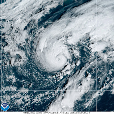
Meanwhile Tropical Storm Martin is right on the edge of becoming a hurricane and should do so later today. 

Satellite view of Tropical Storm Martin, almost a 
hurricane, in the central Atlantic Ocean this morning

Martin is pretty far north for a developing hurricane, being very roughly halfway between Virginia and Portugal. But water temperatures where it is are a little above normal and instability is strong, so Martin is thriving. 

It's also a large sized system and will get bigger in area. It'll get picked up by storminess leaving the Canadian coast.  

Martin will convert into a massive and strong, but non-tropical storm moving northeast or north toward Greenland, then take a hard right turn toward an area north of Ireland and Scotland, at least according to current forecasts. 

After Martin, we might not be quite finished with tropical systems.  Something might get going over the southwestern Atlantic over the next few days.    

A tropical or subtropical storm could form, but it's too early to say for sure whether it will and where it would go if it does manage to get its act together. It could potentially bother the Bahamas or even Florida, but that's more than a week away if it does happen.