Showing posts with label Mexico. Show all posts

Thursday, October 23, 2025

Mexican Flood Another Disaster That Did Not Get Enough Attention

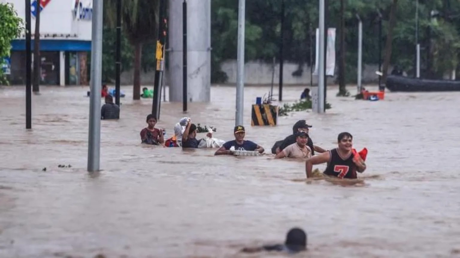
Destruction in Mexico after deadly flooding this month.

 A huge flood and a series of mudslides last week in Mexico killed at least 76 people and caused widespread damage across huge swaths of the country. 

At last report, more than three dozen people were still missing. 

The torrential rains came last week from the remains of Hurricane Priscilla and Tropical Storm Raymond, which sent moisture streaming across central and eastern Mexico. 

Reports Mexiconewsdaily.com:

"The government announced a relief plan of 10 billion pesos (US $543.2 million) to cover damages in Veracruz, Hidalgo, Puebla, Queretaro and San Luis Potosi, pledging rapid reconstruction along with a new cell phone alert for floods and storms."

The storms and flooding damaged 70,445 home. Of those, 43,578 were in Veracruz state. In some areas of Veracruz, two feet of rain fell within four days

In some places the devastation was catastrophic. The entire village of Chapula, population 400, was wiped off the map by a wall of water and mud. 

In one incident, a floating seafood restaurant in Tuxpan, in the state of Veracruz was swept free of its moorings along the raging Tuxpan River and and was launched into the Gulf of Mexico. 

In the Gulf, the restaurant broke into two parts, one of which traveled in the Gulf southward a total of about 350 miles

It's hard to say whether this had anything to do with climate change. It's consistent with a warming world. Rainfall can get more intense than they otherwise would be. So perhaps the rain wouldn't have been as intense had the world not warmed up so much. 

This was one of those disasters that were really huge, but didn't get much media attention. Maybe it's all too much to cover. Or, nobody is interested. Or the media outlets that should cover it don't want to. Not enough clicks on line? Too expensive to cover?  Or maybe we, me, haven't been paying enough attention.

In any event,  I've barely heard about it. There is some coverage from outlets like NBC, like you'll see below. 

Video:

NBC News report from when the confirmed death toll was 60. It gives you a sense of the breadth of this flooding. Click on this link to view, or if you see the image below, click on that. 


Thursday, November 14, 2024

Tropical Storm Sara A Catastrophe For Honduras. But Forecast Is Encouraging For Florida

Satellite view of Tropical Storm Sara already 
unleashing torrential rains on Honduras.
The mess of storminess in the western Caribbean Sea got its act together enough today to be declared Tropical Storm Sara.   

As of late this afternoon, it had top winds of only 40 mph, which certainly isn't a blockbuster in that department. 

But Tropical Storm Sara is a big blockbuster in terms of rain, and it's drenching Honduras with dangerous downpours.  Worse, that state of affairs will continue into most of the weekend. 

The storm's forward speed, already kinda glacial, is slowing down even more. Sara will crawl along the northern coast of Honduras all weekend, at a forward pace as slow or slower than an average person's walking speed. 

All the while, it will dump extreme downpours on the nation, especially in the north. Mountains just inland from the northern coast of Honduras are subject to great rushes of water rushing down the slopes, and catastrophic mudslides. 

Some places could easily see 30 inches of rain. Fatalities are inevitable, I'm afraid. 

SARA'S FORECAST

Expectations of what Sara might do over the next week have changed markedly from earlier this week. Initial forecasts had the storm staying far enough offshore to gain lots of strength from near record warm Caribbean waters. 

Fears grew that Sara would become possibly a powerful hurricane.  And maybe have enough oomph left over to menace Florida.

Florida can't completely let down its guard as of late this afternoon, but residents there can certainly breathe easier. 

Sara's center is now forecast to hug the Honduran coast as it unleashes its cataclysmic rains, so it won't be able to strengthen much. Its interaction with land will probably disrupt its circulation,

Unless Sara somehow manages to edge a little further north into open water, forecasters now doubt top winds will go much above 55 mph or so.

Toward Sunday, Sara should finally get a gentle kick in the pants and start heading northwest into Mexico's Yucatan Peninsula. Since it probably won't be all that strong to begin with, Sara will probably die a relatively quiet death over land down there. 

Originally, Sara was supposed to emerge into the Gulf of Mexico, possibly as a hurricane targeting Florida next week. Now the best guess is that what will be former Sara will cross Florida during the middle of next week as a modest rainstorm.

Things could obviously change.  Tropical systems have surprised us several times this year with unexpected strength and resilience, so Florida should remain aware of this thing, just in case. 

Wednesday, November 13, 2024

Quick Evening Update On Wannabe Hurricane or Tropical Storm Sara

The clouds associated with Wannabe Sara looked much
thicker and more organized than this morning, but still
not organized enough to be a tropical storm.
 The thunderstorms in the Caribbean that the National Hurricane Center have been watching closely a got a lot better organized as we went through the day. 

As of late afternoon, we still don't have a well-defined circulation with this thing, so for now, NHC has settled on temporarily giving it the clunky name Potential Tropical Cyclone Nineteen.

If it develops a circulation and increases its sustained winds to at least 39 mph, this mess will be renamed Tropical Storm Sara.  That transformation into Sara could happen at any time. I'm guessing tonight or tomorrow morning. 

This looks really ominous for Honduras. Wannabe Sara is headed that way, and forecasts indicate it will stall near that nation's coastline Friday and the weekend. So, it'll basically sit there and dump buckets of rain there for days. 

One to two feet of rain could easily fall on northern Honduras because of this storm. Needless to say the flooding and landslides if that happens would be catastrophic.  

This sort of reminds me of Hurricane Mitch in 1998, which caused immense flooding in Honduras and Nicaragua that claimed 11,000 lives. Mitch was much stronger than Sara is expected to become, so let's hope things go much better than they did in 1998.

After its expected big stall, Wannabe Sara is expected to start moving northwestward, probably crossing Mexico's Yucatan Peninsula next week.   It could move slowly over land and greatly weaken. Or it could brush the edge of the peninsula and maintain a decent amount of strength. 

That has eventual implications for Florida. Uncertain long range forecasts have Wannabe Sara emerging into the Gulf of Mexico and then heading north and east toward Florida. Might not happen, but that's the consensus for now.

The question is, will Sara at that point be a hurricane, or will be a sloppy, weak mess by the time it gets to Florida, if it does. 

We'll have to wait and see 

Wednesday, October 2, 2024

Not Just Southeast United States: Nepal, Mexico In Crushing Floods

Extensive flooding in Kathmandu, as seen in this
aerial view. AP Photo by Gopen Rai.
While we in the United States are dealing with apocalyptic floods in the Southeast, other spots in the world are dealing with much the same thing. 

Both Nepal and Mexico in the past week have endured floods on the scale, or nearly on the scale of what we've seen in North Carolina and surrounding states.  

NEPAL

The flooding in Nepal focused in and around Kathmandu, where torrential rains have hit since Friday. In Nepal, at least 193 people have died and more are missing, according to the Associated Press.

Much like Asheville, North Carolina, Kathmandu was largely cut off from the outside world due to the flooding. Though Kathmandu is much bigger than Asheville, with a population of about 850,000.

Rainfall with this storm ranged from about nine to 12 inches in and around Kathmandu, leading to the flash flooding. That's about the normal rainfall there for the entire month of September. 

The trouble in Nepal was also wide-ranging and multifaceted. One example, according to the AP:

"A landslide killed three dozen people in a blocked highway about 10 miles from Kathmandu. The landslide buried at least three buses and other vehicles where people were sleeping because the highway was blocked."

The flooding hit near what is usually the tail end of Nepal's monsoon season. 

Poor land use made the flooding in and around Kathmandu worse than it otherwise would have been, as Al Jazeera reports:

"Urban planner Neeraj Dangol said multiple factors were behind the latest disaster.

The Basmati River, he says, was narrowed due to haphazard planing and urban development that took place after a drastic population boom in Kathmandu in the early 1990s. 

'In the past 40-50 years, houses and roads have been built on areas that used to be part of the river system,' Dangol explained."

Formerly porous agricultural land, which used to absorb water, is now covered in concrete, which increases runoff. There's also been a lot of deforestation in Nepal, which also contributes to worse flooding.

Finally, as in so many other places the world, climate change has increased the intensify of rain storms, which of course worsens flooding. 

 MEXICO

Severe flooding in Acapulco due to Hurricane John
Parts of Mexico's Pacific Coast and nearby mountains are reeling from what's been described as "Zombie" Hurricane John.

It was called that because it smacked into the Mexican coast southeast of Acapulco last week as a Category 3 hurricane. It then dissipated inland, and you'd think that was that.

But then the remnants drifted back out over the warm Pacific Ocean waters, regenerated into a hurricane and then again hit the Mexican coast. That's why Hurricane John has been called "zombie." 

The effects were devastating. The BBC reports some places had nearly a year's worth of rainfall in just a few days. 

Acapulco, completely trashed by Hurricane Otis last year, was only just getting a recovery into swing when Hurricane John hit, flooding swaths of the resort city. City officials pleaded with anyone had boats to help rescue people in flooded neighborhoods. Some families were stranded on roof while the water rose around them. 

So far the death toll from these floods has been placed at anywhere between 15 and 29, but that is expected to rise.  

Videos

Scenes from Nepal this week really are similar to those I've seen from North Carolina. Click on this link to view, or if you see the image below, click on that:


In Mexico, landslides were also part of the disaster due to "Zombie" Hurricane John. Again, click on the  this link to view or if you see the image below, click on that. 


Thursday, July 4, 2024

Quick Fourth Of July Hurricane Beryl Update: Weakening, But Still Formidable. Texas Monitors It

Hurricane Beryl still looks like it's getting disrupted
by strong upper level winds. But look closely.
It still has a pretty symmetrical core and an eye
which means the storm is still resisting
atmospheric conditions that want to weaken it faster.
 As expected, Hurricane Beryl has weakened more today, but it's still doing pretty well for itself despite strong upper level winds that want to rip it apart.  

In  satellite photos, the outer edges of it looked like a mess the afternoon, but if you looked closely, the inner core is nice and round with an eye still visible. That means some of the damage to Beryl from those winds are being deflected.

Still, Beryl is forecast to keep slowly weakening, then diminish faster as it crosses Mexico's Yucatan Peninsula tomorrow. 

Then it will re-emerge over the southwestern Gulf of Mexico as a 60 mph tropical storm, at least if forecasts are correct. Could we weaker at that point, could be stronger.

After that, Beryl is expected to slowly strengthen again as it moves over the warm Gulf of Mexico. One sort of good thing is that an earlier tropical storm. Alberto, churned up that section of the Gulf of Mexico in mid-June, which makes the surface water a little cooler.

If the water is a bit cooler, it can't fuel a hurricane as much as water that is really, really warm. 

Beryl is still forecast to become a hurricane before landfall.  That landfall looks like it will be somewhere between Tampico, Mexico and Galveston, Texas Sunday or Monday. 

Wednesday, July 3, 2024

Hurricane Beryl Not Going Down Without A Fight

Satellite view of Hurricane Beryl shows it looking
much less organized and symmetrical than 
yesterday as strong upper level winds 
disrupt it, but it's still managing to hold on
as a powerful, dangerous storm. 
 As of this afternoon, Jamaica is the latest island to be trashed by extreme, intense oddball Hurricane Beryl as the storm gets ready to hit, or at least make a close pass at that nation.  

Despite more than 24 hours of a hostile upper atmosphere, Hurricane Beryl still had maximum sustained winds of 140  mph as of late this afternoon.

 The storm still has the Cayman Islands, Mexico's Yucatan Peninsula, Belize and possibly southern Texas in its sights. 

Hurricanes don't like strong upper level winds. Those winds disrupt the nice round circulation of tall powerful thunderstorms that make up the ring of scary weather around the storm's eye.

When those upper level winds - known as shear - hit a hurricane they almost always weaken. 

Such is the case with Beryl, but the process has been stubbornly slow.  It's amazing that after 24 hours of westerly upper level winds, the central winds were still that 140 mph late this afternoon, down from its peak of 165 mph yesterday.  

If anything, Beryl actually looked more organized late this afternoon than it did this morning, which is definitely unexpected. 

Beryl has consistently kept meteorologists surprised, mostly because of its early season intensity, its development in an area of the Atlantic where hurricanes aren't "supposed" to develop until August, and now Beryl's reluctance to weaken in an atmosphere where it should be having some trouble. 

That slow pace of diminishing is why Jamaica is taking such a hit. The hurricane hadn't made its closest approach to Jamaica this afternoon and Kingston has already reported sustained winds of 48 mph with gusts to 81 mph, says the National Hurricane Center. 

Ferocious  winds will destroy tons of buildings in Jamaica, especially near the south coast. Torrential rains in Jamaica's steep mountains will cause violent flash floods and mudslides - they've probably started already as I write this at midafternoon eastern time. 

The destruction left behind is still being assessed in places like Grenada, where Prime Minister Dickon Mitchell said destruction on the nation's island of Carriacou is "almost Armageddon-like.

Drone video taken over Carriacou makes the entire island look like it was put into a giant blender. Pulverized pieces of houses were everywhere. Most buildings lost parts or all of their roofs. 

Per CBS News: 

"'Almost total damage or destruction of all buildings, whether they be public buildings, homes or other private facilities,' Mitchell said. 'Complete devastation and destruction of agriculture. Complete and total destruction of the natural environment. There is literally no vegetation left anywhere on the island of Carriacou.

Carriacou, which means 'Isle of Reefs' is just 13 square miles, but is is the second-largest island within Grenada. Beryl's size and strength completely overpowered the island, as well as its neighbor, St. Vincent and the Grenadines' Union Island, which saw 90 percent of its homes severely damaged or destroyed.

Clare Nullis, a spokesperson for the World Meteorological Organization, said earlier this week that 'it takes only one landfalling hurricane to set back decades of development.'"

With climate change increasing the risks of super hurricanes like Beryl, that of course is bad news. Island nations are a dime a dozen in and near the Caribbean. 

There's been a slew of big hurricanes in recent years, and there's no reason to think it will stop this year. Most experts say the rest of this hurricane season will be extraordinarily busy. Hurricane Beryl suggests these forecasts might end up being right. 

After today, Beryl will continue its weakening trend, but will probably still be a hurricane by the time it reaches the Yucatan Peninsula in Mexico by Friday morning. 

Time spent over land in Mexico will ensure Beryl weakens to a tropical storm. But meteorologists with the National Hurricane Center worry Beryl will get a new lease on life when it emerges over the warm waters of the southwestern Gulf of Mexico on Saturday.

It could strengthen into a hurricane again before hitting northeast Mexico or southern Texas by around Sunday or Monday.  Forecasts trends have been shifting the expected path of Beryl northward.  Earlier forecasts indicated it will make landfall again well south of Texas

Now, forecasts vary, but it could come ashore somewhere within spitting distance either side of the Mexico/Texas border.


Wednesday, June 19, 2024

First Tropical Storm Of The Season Inundates Texas, Mexico Coasts

Tropical Storm Alberto forming large messy swirl in
the western Gulf of Mexico Wednesday afternoon. 
 We finally have our first named tropical storm in what is widely predicted to be a very busy Atlantic season.  

Tropical Storm Alberto officially formed late this morning in the midst of this huge swirl of storminess in the southern Gulf of Mexico.

Its wind power is modest. Top sustained winds are about 40 mph. Those winds will probably increase only slowly before Alberto splashes ashore in northeastern Mexico early tomorrow morning.

However, Alberto is causing a lot of coastal flooding in Mexico, Texas and Louisiana. 

Size matters. Alberto itself is just part of that huge whirl of storminess in the Gulf. That's pushing water eastward and northeastward into northeast Mexico, Texas and parts of Louisiana.

 As a result, tropical storm and coastal flood warnings extend all the way up to Galveston, not far from Houston. That coastal flooding extends all the way to along the entire Louisiana coast. 

The storm surge in Texas might actually end up being worse than in Mexico, near where the center comes ashore. Video shows quite a lot of flooding in Surfside Beach, Texas and a number of other coastal resort towns.

Rainfall with this thing is serious, too. Five to 10 inches of rain could fall in southern Texas and up to 20 inches in the mountainous areas of northeast Mexico.  Needless to say, inland flooding is a big risk

Even after Alberto goes inland and dies Thursday, a swirl of storminess will remain in the southwestern Gulf of Mexico. Next week, that swirl could spit out another tropical storm, much like Alberto.  That's uncertainty, but forecasters are looking at that risk. 

Another disturbance northeast of the Bahamas is expected to move westward toward Florida or the southeast Coast.  Forecasters give that thing a low but not zero chance of turning into a tropical storm before hitting the coast. 

Tuesday, May 28, 2024

"Heat Dome" That's Been Baking Mexico Spreads To U.S.; Could Impact Rest Of Nation Over The Summer

A schematic of a heat dome over the middle of the
United States. In a heat dome, high pressure
causing sinking air, which ensures strong sun
trapping hot air in place. 
What is known as a "heat dome" - a persistent, torrid high pressure system, has been baking Mexico, Central America and the Caribbean, has been expanding in recent days and weeks to affect the United States.   

Heat domes are fairly common mostly over continents in the summer. But they've been getting more intense with climate change. 

The latest heat dome has been killing people, causing droughts and fires, and also triggering intense storms,  especially along its edges.

Mexico City residents are rationing water as drought dries up supplies. The city could run out of water as early as June 26, even as the region's hoped for rainy season starts about then, according to Axios.

The Mexican heat has been brutal on wildlife, too. Mexico's famous howler monkeys have been dying in the heat. As of Sunday, 157 of the monkeys had succumbed in southern Mexico. An endangered salamander looks like it might go extinct because of the heat. 

All time record high temperatures have been set in parts of Mexico, Belize and other Central American and Caribbean nations. 

 The heat has been making inroads into Florida and Texas in recent days. 

Del Rio, Texas reached 109 degrees last week, setting an all time record high for the month of May. 

As of Sunday, four of Houston's 20 hottest May days since the late 1880s happened this month. 

There's been little relief from the heat at night. Kingsville, Texas recently had an overnight "low" of 84 degrees, the highest low temperature on record in May for anywhere in Texas. 

The heat index in Miami was 112 degrees on both May 18 and 19.  That's only happened once before, in  August of last year. But it's only May, so that episode was especially bizarre.

SUMMER DANGER

All this adds a potentially ominous tone for the summer in the United States. It's inevitable that the heat dome will expand into the  Lower 48 and perhaps southern Canada as we move through June, July and August. 

Most likely, it will persist for a few days over a certain region, then shift to somewhere else and back again.  Given the intensity of the heat dome and climate change, this could lead to dangerous all time record highs at the height of summer. 

An intense heat dome in the Pacific Northwest and southwestern Canada in 2021 led to the all-time record high for  Canada of 121 degrees in Lytton, British Columbia. That town burned down the next day in a wildfire that was greatly accelerated by the heat and drought. 

The 2021 heat wave killed 619 Canadians and dozens of people in the U.S. Pacific Northwest as temperatures climbed into the 110s in many locations. 

We risk a similar disaster this summer, but of course we don't know where yet. 

The summer heat dome could also pretty much park itself over one location for much of the summer, like it did in Mexico this spring. That would cause weeks of record high temperatures, deaths from heat and flash droughts.   

HEAT DOMES, CLIMATE CHANGE AND US 

Heat domes have always been a thing. The intense heat and dust bowl droughts of the 1930s were in large part caused by heat domes. 

Climate change is helping to intensify heat domes, here in North America and in Europe and Asia, where heat waves have killed tens of thousands in recent years. Heat waves are not photogenic like most disasters like hurricanes and tornadoes. But heat is the deadliest type of disaster, so they should be taken more seriously than they are. 

We obviously don't know whether or how much any heat domes will affect us here in Vermont. 

Even in this cool, temperate corner of the world, heat can be dangerous in Vermont. An intense July, 2018 heat wave caused six deaths in Vermont and dozens up in Quebec, for instance. 

Again, because of climate change, I think the all time record high temperature in the Green Mountain State - 105 degrees in Vernon, in July, 1911 - might well be broken within the next decade. I imagine Burlington's all-time high of 101 will be challenged, too.

I'm not saying that will happen this year. I imagine it could, but it's all the roll of the dice. 

Long range forecast call for a hot summer in the United States, with the best chance of persistent heat in the western United States and in New England. 

It's been one of the warmest Mays on record in Vermont. Who knows whether that trend will last through the summer. But I'd bet on at least some brutal heat in the coming months. 

Saturday, November 19, 2022

Florida Hurricanes In 2004 and 2022 Eerily Similar. And Other Strange Tropical Coincidences

The Washington Post gave us this graphic, showing
the remarkable similarities in paths for hurricanes Charle
and Jeanne in 2004, and Ian and Nicole
in 2022
Now that Hurricane Nicole is long gone, the Washington Post and many other meteorologists are struck by a strange Florida hurricane coincidence.  

In 2004, powerful Category 4 Hurricane Charley roared ashore from the Gulf of Mexico into Cayo Costa, Florida. It moved northeastward across the state. Just 43 days later, Hurricane Jeanne came in off the Atlantic and hit the east coast of Florida, making landfall south of Daytona Beach.  Jeanne's path crossed Charlie's in central Florida.

In 2022, powerful Category 4 Hurricane Ian roared ashore from the Gulf of Mexico into Cayo Costa  Florida. It moved northeastward across the state. Just 43 days later, Hurricane Nicole came in off the Atlantic and hit the east coast of Florida, making landfall south of Daytona Beach. Jeanne's path crossed Ian's in central Florida.

You probably noticed the similarities between the two previous paragraphs. 

The Washington Post reports the similarities between the four storms was first noticed by Matt Devitt, chief meteorologist for Tampa television station WINK.

In that busy hurricane season of 2004, Hurricane Frances and the above mentioned Hurricane Jeanne came ashore in Florida at the exact same spot, Hutchinson Island, less than three weeks apart. 

Weather is so complicated, with so much going on, there's bound to be strange coincidences. There's a few others that involve tropical storm, like the double Allison the Weather Channel highlights 

In June, 1989, Tropical Storm Allison, came ashore near Houston and meandered around southeastern Texas and Louisiana for days. The slow moving storm dumped 10 to 25 inches of rain, which produced flooding that killed 11 people.

The National Hurricane Center rotates through names that are repeated once every sixth year. If a hurricane is especially notorious, the name is retired and replaced. Allison was not deemed big enough to be replaced.

Which meant another Tropical Storm Allison came ashore near Houston in 2001. Like the previous Allison, it meandered around southeastern Texas for a few days, dumping up to 40 inches of rain and producing catastrophic flooding that killed 23 people.

With that, the National Hurricane Center decided to retire the name "Allison" from its roster.

On Sept. 16, 1988, Gilbert, which had been a monster Category 5 storm with the lowest pressure ever observed in the Western Hemisphere up to that point, landed as a Category 3 cyclone at La Pesca, Mexico. 

Twenty-five years later on the exact same date, high end Tropical Storm Ingrid hit the exact same spot - La Pesca, Mexico.

In 2021, two dying tropical storms  came ashore within a month or so of each other in Westerly, Rhode Island.  Elsa hit Westerly at 12:15 p.m. July 9.  Henri limped into Westerly on August 22 at - you guessed it - 12:15 p.m. 

By the way, another tropical storm hit the unlikely target of Westerly in 1985.  It's name? Henri.  Yep, another one.  

Wednesday, June 1, 2022

Hurricane Season Might Be Getting Off To A Fast Start

Satellite photo from showing United States, Mexico, the 
Gulf of Mexico and the western Atlantic Ocean. That mess
of clouds in the southern Gulf of Mexico could become 
Tropical Storm Alex.
 Officially, the hurricane season for the Atlantic Ocean side of North America begins today, June 1, and there's already a tropical storm threat to talk about. 

The National Hurricane Center is giving a disturbance near Mexico's Yucatan Peninsula a high chance of developing into a tropical depression or storm.  If it does form, it appears it's poised to give Florida  and Cuba an absolute drenching. 

At least a half foot of rain is forecast in both places, which of course could lead to some pretty nasty flooding. 

If this thing develops into a tropical storm, they'll name it Alex. It'll probably fall short of becoming a full-fledged hurricane, as strong upper level winds are and will be interfering with its development. That's typical early in the hurricane season.  

Usually upper level winds are stronger and ocean temperatures are cooler in June than in, say, August.  That's why early season storms are usually (but not always!) weaker than the powerhouse hurricanes later in the summer and early autumn. 

That said, there's two factors that are helping wannabe Alex.  Ocean temperatures in the Caribbean Sea and Gulf of Mexico are warmer than normal. Plus, wannabe Alex is getting energy from what once was Hurricane Agatha.

On the Pacific Ocean side of North America, hurricane season starts May 15, and we've already had our first hurricane. This was definitely an exception to the rule that June tropical systems are weak.

Agatha was the strongest landfalling hurricane in May with winds of at least 105 mph when it came ashore a couple days ago in the southern state of Oaxaca, Mexico. It killed at least 11 people and 20 people are still missing after the flooding and mudslides caused by Agatha. 

Agatha fell apart over the mountains of southern Mexico as all landfalling hurricanes lose steam over land. But its remnant energy is feeding into the disturbed weather near the Yucatan Peninsula, which could help wannabe Alex get its act together. 

If wannabe Alex develops into a tropical storm, it won't be the earliest on record. Despite the fact that hurricane season officially starts on June 1, there have been tropical storms in May. There has even been three Atlantic Ocean tropical storms recorded in April, the most recent being in 2017.   

The National Hurricane Center predict this year will be another very busy one in the Atlantic Ocean, due to a number of factors. Those include a continuing La Nina global weather pattern and ocean temperatures that are mostly running warmer than normal. 

Wednesday, October 7, 2020

Delta Dawn: Hurricane (Temporarily) Weaker This Morning; Vermont Gusts

After setting records for the fastest rate of intensification for any Atlantic tropical system, Hurricane Delta abruptly weakened somewhat on approach to the area around Cancun, Mexico.  

Hurricane Delta centered over Mexico's Yucatan Peninsula
this morning. The cloud bands filling up the
entire Gulf of Mexico are pretty interesting. They contain
showers, but not very serious weather near the U.S. coasts.
That will change as Delta draws closer. 

Delta caused a lot of damage in that area, according to early reports, but it wasn't the devastating blow in could have inflicted on the tourist area. 

Meanwhile, Louisiana and Mississippi are bracing for what Hurricane Delta might have in store for them. 

The following stat might be most exciting for weather weenies like me, but it's really telling as to what unusually warm ocean water and light upper level winds can do. 

Hurricane Delta's winds increased from 35 mph to 130 mph in just 36 hours. According to hurricane experts Sam Lillo and Tomer Burg, that's the fastest transition from a tropical depression to Category 4 hurricane on record in the Atlantic Basin. 

Although I can't directly attribute this to climate change, it is a testament to what warming ocean waters can do if the conditions are right. 

Hurricane Delta's winds peaked at 145 mph last night before it faded to a Category 2 storm with top winds of 105 mph on Mexico's Yucatan Peninsula. 

Delta will continue northward and emerge into the southern Gulf of Mexico today.  If it manages to reorganize after getting disrupted by its short trek over land, this hurricane has the potential to ramp up to a Category 4 storm again.  (Category 4 storms have sustained winds of between 130 to 156 mph).

This has implications for what happens on the U.S. Gulf Coast. Forecasters are pretty sure Hurricane Delta will start to weaken again as it approaches the coast - likely Louisiana on Friday. 

If Delta starts from a stronger position - Category 4 - it will be more intense at the coast than if the storm doesn't ramp up as much as expected today.

I guess this will be a choice between bad and really bad for the United States. Meteorologists are saying Delta will expand in size over the Gulf of Mexico.  A larger hurricane tends to create larger storm surges.  Those surges can live on until they smash ashore even if the parent hurricane weakens. 

Nobody is quite sure where on the Louisiana coast Delta will hit, but the options are bad. If it's closer to New Orleans, that would put the city under the gun for storm surge flooding and the risk of levee failures. '

If it hits further west, New Orleans gets off relatively easy, but then areas hit hard by Hurricane Laura earlier this year get smacked again. It's kind of a no-win. 

Forecasting the intensity of a hurricane is still really hard, as we saw with forecasts for this Hurricane Delta. 

Best guesses are that Delta will come ashore as a Category 2, but who knows, really?

Delta, of course will weaken wicked fast after it makes landfall. It will produce heavy rains over the lower Mississippi Valley over the weekend. 

It's too soon to determine if any moisture from Delta makes it far enough north to affect Vermont. We can still use the rain, for sure. Early guessing is we will get little rain from Delta, but that's not a sure bet. 

At least we're getting a bit of rain today, though

STORMY VERMONT WEDNESDAY

As expected, a pretty stiff storm system is expected to cross southern Quebec today. This means wind, rain, and possibly scattered severe thunderstorms in Vermont today. 

Whether you're in a thunderstorm or not, southwest winds will gust to between 30 and 45 mph.  Strongest winds look like they will be on the east facing slopes of the Green Mountains and Adirondacks.

There will be quite a few showers around today, with the most rain likely in the mountains. The Champlain Valley will get less rain because the Adirondacks will block some of the moisture blowing in from those southwest winds 

A band of bands of showers and possible thunderstorms will form ahead and along the storm's cold front this afternoon. Some of storms could grab some really high speed winds up above us and bring a couple damaging gusts to the surface. 

Most of us won't see that, but a few of us might, so be on the lookout for that. 

Today's storms likely will have little or even no lightning, so don't rely on distant rumbles of thunder to alert you that something's coming.