 |
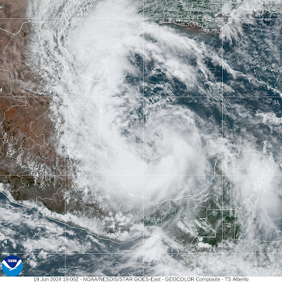
| Tropical Storm Alberto forming large messy swirl in the western Gulf of Mexico Wednesday afternoon. |
Tropical Storm Alberto officially formed late this morning in the midst of this huge swirl of storminess in the southern Gulf of Mexico.
Its wind power is modest. Top sustained winds are about 40 mph. Those winds will probably increase only slowly before Alberto splashes ashore in northeastern Mexico early tomorrow morning.
However, Alberto is causing a lot of coastal flooding in Mexico, Texas and Louisiana.
Size matters. Alberto itself is just part of that huge whirl of storminess in the Gulf. That's pushing water eastward and northeastward into northeast Mexico, Texas and parts of Louisiana.
As a result, tropical storm and coastal flood warnings extend all the way up to Galveston, not far from Houston. That coastal flooding extends all the way to along the entire Louisiana coast.
The storm surge in Texas might actually end up being worse than in Mexico, near where the center comes ashore. Video shows quite a lot of flooding in Surfside Beach, Texas and a number of other coastal resort towns.
Rainfall with this thing is serious, too. Five to 10 inches of rain could fall in southern Texas and up to 20 inches in the mountainous areas of northeast Mexico. Needless to say, inland flooding is a big risk
Even after Alberto goes inland and dies Thursday, a swirl of storminess will remain in the southwestern Gulf of Mexico. Next week, that swirl could spit out another tropical storm, much like Alberto. That's uncertainty, but forecasters are looking at that risk.
Another disturbance northeast of the Bahamas is expected to move westward toward Florida or the southeast Coast. Forecasters give that thing a low but not zero chance of turning into a tropical storm before hitting the coast.

No comments:
Post a Comment