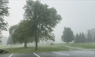
Most of the state got through Sunday with no trouble at all. It seems like the middle of the Green Mountain State took the brunt of the weather.
While there was definitely wind damage, some of the biggest trouble Sunday stemmed from flash flooding.
Sunday's two most intense storms - both of which carried tornado warnings - hit pretty much the same areas in central Vermont, touching off tree damage, power outages and flash flooding
Here's what I saw.
STORM #1
The National Weather Service in South Burlington at 2:07 p.m. Sunday issued a tornado warning. for an area around Monkton, Starksboro and Huntington, and extended the tornado warning to areas around Waterbury, Waitsfield and Montpelier at 2:28 p.m.
I definitely did not see a tornado, as I was a little bit north of where the storm rotation was. But the area I was in at the Cedar Knoll Country Club experienced gusty west winds, followed quickly by even stronger southeast winds and torrential rains.
That was potentially influenced by some sort of circulation a little to the south of me, or it could have been simply the orientation of downbursts.
After the storm I traveled down Route 116 through Starksboro where if a tornado existed it would have crossed. At that particular point along Route 116 the only damage I saw was a few branches down and some minor flash flooding.
STORM #2
Later in the afternoon, a fairly unimpressive looking storm in eastern New York intensified as it splashed ashore on the Vermont side of Lake Champlain.
It developed torrential rains and gusty winds where I was in South Burlington and Shelburne around 4 p.m., then intensified further as it moved east. At 4:07 and 4:12 p.m., the National Weather Service issued a pair of severe thunderstorm warnings for a zone extending from central Chittenden County all the way to areas around Morrisville, Waterbury, Worcester, Montpelier and Johnson.
That severe thunderstorm warning in a broad area around Waterbury was renewed at 4:43 p.m. Meteorologists at this point must have been beginning to see signs of rotation because they added the following sentences to this new severe storm warning: "Remain alert for a possible tornado! Tornadoes can develop quickly from severe thunderstorms."
At 4:51 p.m., a tornado warning was issued for an area in and around Waterbury. Around that time, numerous trees were reported uprooted or snapped off at Little River State Park in Waterbury, which was in the middle of the tornado warning zone.
From what I can tell, the damage patterns reported didn't warrant the National Weather Service going out for a look see. So for now, we can conclude we had rotation, but no actual tornadoes with this episode. Close but no cigar. Though if something changes, I'll update you.
FLASH FLOODING
Those two intense storms hit roughly the same areas. Both storms contained ferocious downpours. There were quite a few damage reports. I saw some flash flooding on French Hill in Williston, and it goes worse as the storms reached peak intensity further east.
Parts of the Bolton access road were damage, as was Route 100 between Waterbury and Stowe. Part of Route 12 in Worcester was closed.
Part of Route 14 in Hardwick was also shut down due to high water. A bridge washed out on Elmore Mountain Road, and other road damage was seen around Elmore and Worcester.
In Stowe, Stowe Hollow, North Hollow, Moss Glen Falls roads and others in town were damaged and in many cases impassable.
Damage from flooding in Vermont Sunday was definitely worse than wind or potential tornado damage.
OUTLOOK
Much calmer today in Vermont. Today was cloudy and showery across much of Vermont, though some afternoon sun broke out in the northwest. It's been a refreshingly cool one after all the humidity we've had lately.
After a bright and much warmer Tuesday, the next chance of severe weather comes with some weather fronts Wednesday. The prospect for bad storms Wednesday is still really iffy, and so far, trends have been moving away from a severe risk, so fingers crossed!


No comments:
Post a Comment