Showing posts with label freezing fog. Show all posts

Thursday, November 20, 2025

Freezing Fog Ices Vermont Trees Beautifully, Ices Roads Dangerously

Freezing fog this morning in St. Albans, Vermont
coated tree branches with delicate rime ice
A rare freezing fog advisory was in effect for the
Champlain Valley this morning. 
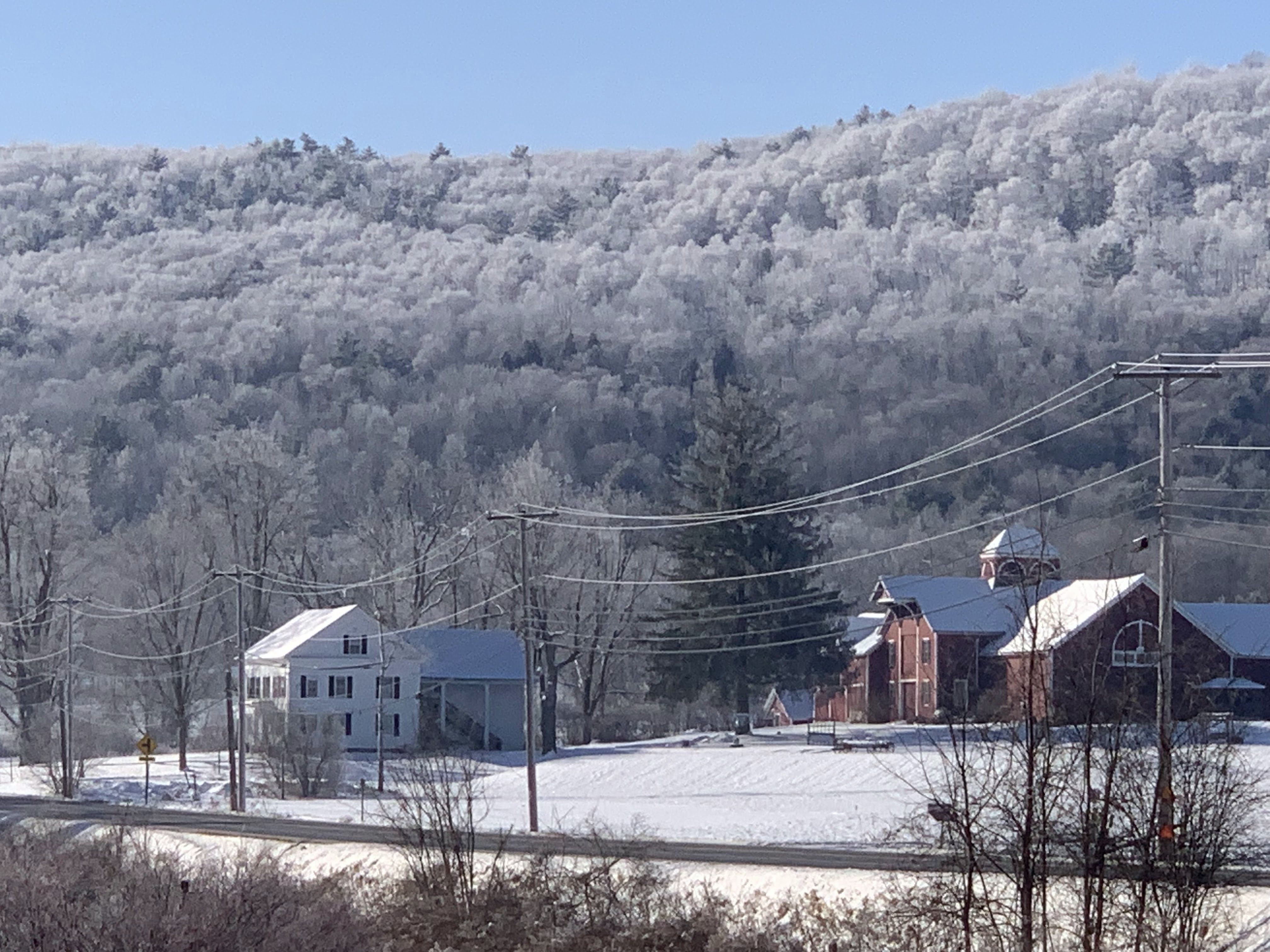
Freezing fog enveloped large parts of Vermont overnight, especially in the Champlain Valley. It left trees and pretty much everything else outside coated in ghostly white ice.   

And made things challenging on the roads. 

Freezing fog is when all the droplets in the fog are still liquid, even though the temperature is under 32 degrees.

As soon as these supercooled droplets as they're called  hit anything - a road, tree branches, your cold car windshield, they freeze.

On trees and other outdoor objects, the frozen water takes the form of rime ice, a delicate, feathery feature that is absolutely beautiful. 

On roadways, freezing fog forms virtually invisible black ice on pavement, especially on bridges and overpasses. 

The fact that in some cases only bridges are frozen, motorists are often taken by surprise. If they're going too fast, you can get some serious crashes. Especially if the freezing fog is thick and visibility is horrible, like it was in many areas in and near the Champlain Valley overnight and this morning. 

Freezing fog happens from time to time in Vermont. We had a bout of it around Christmastime last year.  When the sun hit those frosted trees, the scenery looked magical. It made the holiday season look that much better. 

Rime ice from freezing fog formed icy little 
needles on this St. Albans pine branch this morning, 
This morning's freezing fog was particularly dense in many spots. So dense that the the National Weather Service in South Burlington issued a freezing fog advisory for the entire Champlain Valley.

 It was the first time the Vermont NWS office issues such an advisory in a decade. 

The advisory stays in effect until 10 a.m today. If you're reading this early and planning on a drive, take it slow, keep your low beams on, and really be careful around those bridges and overpasses. And try to leave as much room as you can between you and the vehicle in front of you, 

The freezing fog should gradually lift during the course of the morning. At first it will probably transition to a low overcast. Eventually, the sun should break through for at least some of us.. 

It's tricky to determine when or if the sun will actually make an appearance. In warmer times of the year, the sun heats everything up enough to create updrafts that mix the air and evaporate the fog. 

This time of year the low angle of the sun means it can't heat things up enough to readily break up the fog. Some parts of the Champlain Valley could stay under the clouds all day. Or at least most of the day. 

Outside the Champlain Valley, there was much less fog, so other sections of Vermont will just have another partly sunny, cool November day. 

Tonight, the wind will begin to stir as a weather front begins to make an approach. Those winds should prevent another round of freezing fog from forming. Except maybe in the deeper valleys of eastern Vermont. 


Friday, December 27, 2024

Strange, Extreme Temperature Inversion To Finally Break, Then Freezing Rain, Then Rain To Mar Runup To New Year

Freezing fog under an inversion broke up Thursday 
morning, leaving frosted trees glistening above an
old farmstead near Wallingford, Vermont. 
 Though it might not seem it to the casual observer, the weather has been really strange from Christmas Day to this morning in and near Vermont. 

As previously forecast, an extreme temperature inversion has taken hold.  To remind you, an inversion is when it's warmer aloft or up in the mountains than in the valleys. Usually the opposite is true. 

Inversions are more common in the winter around here, but this one is really something. 

Atop the high peaks of the Adirondacks Thursday morning, like the summit of Mount Marcy, temperatures remained in the mid 30s, even at night as temperatures in the coldest valleys got down to below zero readings. That's about as extreme a temperature inversion as I've ever seen.

The inversion has trapped the steam coming off unfrozen Lake Champlain, creating a widespread blank of low clouds and fog to spread out from the lake and cover most of western Vermont and nearby New York, both yesterday morning and this morning. 

With light north winds, I noticed the clouds were never able to break up Thursday downwind of Lake Champlain. Much of Addison County, southern Chittenden and northern Rutland counties remained socked in with clouds, even as most other areas cleared.

Where the low clouds and fog did break up in those chilly valleys, the freezing fog left behind a beautiful frost on all the trees, lit up by the low angle late December sun. It was an example of how inversions can be stunningly beautiful.

Freezing fog early Thursday left these trees in 
West Rutland, Vermont beautifully frosted over. 
This morning, temperatures in the inversion remain topsy turvy to the extreme. Under clear skies early this morning, it was 9 below at Lake Eden, Vermont and minus 7 in Morrisville. The low clouds and fog from Lake Champlain kept Burlington a little warmer at 14. 

Meanwhile, it was still in the low 30s in the high peaks of the Adirondacks. The summit of Mount Washington, New Hampshire, a place you usually find extreme cold, it was a balmy 28 degrees a little before dawn.  

Freezing fog has been an issue in spots and night, but it's been beautifying our surroundings during the day, especially where sun breaks out. The sun glistening on trees frosted over by the fog is just stunningly beautiful, so enjoy that if you see it. 

FREEZING RAIN

The inversion will gradually fade as the strong high pressure system finally exits in favor of that storminess we've been watching approach. 

Still, the inversion's fading glory will cause new problems.  That warm air aloft will continue flowing in, and will try to work its way down into the valleys. But only grudgingly.  An initial wave of precipitation is forecast to push northward into New England  Saturday while fading as it encounters dry air over Vermont and New Hampshire. 

What does arrive will start out as plain rain as it falls through the mild air a few thousand feet overhead. But it will probably freeze on impact as it lands in the cold air and cold ground down southern Vermont valleys. 

A winter weather advisory is up for the southernmost two counties of Vermont and adjacent areas of New York Saturday as that freezing rain arrives.  It won't come down hard, so there will be no issues  with trees and power lines, but there will be icy problems on the highways. 

There's some question as to  how far north Saturday's freezing rain will get, but a little dab will do ya - Even 0.01 inches of freezing rain is more than enough to make roads and sidewalks dangerous. I have a feeling those Saturday winter weather advisories might get extended at least into central Vermont.  

Not sure yet, but it's something to watch.

A more substantial surge of warmth and moisture will push northward Sunday, so we get more rain. Some valleys in eastern Vermont might not be above freezing yet even on Sunday, which opens the door for more freezing rain. 

In western Vermont, temperatures are forecast to be above freezing when the rain arrives, but that might not be much help. 

The air temperature might be in the mid and upper 30s while it's raining Sunday, but the ground will not have recovered from the cold valley temperatures we've had under this week's inversion.

 Pavement, concrete, etc. will still be below freezing, so that rain Sunday would probably freeze on roads, sidewalks and driveways. Especially if they haven't really been hit with the state and municipal salt shakers that I expect will be out. 

Eventually, it will warm up everywhere in Vermont by Monday for just plain rain. 

Saturday, January 27, 2024

Another Vermont Fog Attack As Gloomy Winter Continues

Crows gather on trees amid dense fog and freezing
drizzle Saturday morning in St. Albans, Vermont. 
 The murk and fog that's been plaguing Vermont this week - all winter, really - intensified last night,  blinding motorists and laying down a very thin but potentially dangerous layer of ice on some road surfaces.  

Meanwhile, far southern Vermont is under a winter storm watch. More in that further below

The dense fog advisory for all of Vermont is in effect until 10 a.m. today. Visibility in some areas was down to a mere 50 feet. If you're caught in that on the roads, you'd better be driving really slowly. It's hard to see even bright tail lights ahead under those conditions. 

I noticed some flights are late or delayed at the Patrick Leahy Burlington International Airport in South Burlington, so check your flights if you're coming in or out of Burlington today. 

Temperatures throughout the Green Mountain State started the day at around 32 degrees, so the fog was freezing on some surfaces. 

Jackson the Weather Dog encountered our icy driveway in St. Albans, Vermont when he went out early today to take observations on the dense fog and temperatures. Jackson noted a little freezing drizzle was also falling here in St. Albans, and I'm sure in several patches elsewhere in the state.

The fog is part of a national weather pattern I posted about the other day which has been socking in wide areas of the nation. Widespread fog broke records midweek for the amount of land they covered.

Traffic cam showed foggy conditions on Interstate 89 in
Georgia, Vermont this morning. 
This morning, there was slightly less fog in the nation than earlier, but it was still remarkably widespread. Especially for midwinter.

In addition to Vermont, dense fog advisories this morning covered most of the states around the western and southern Great Lakes, parts of the northern Plains and numerous spots up and down the East Coast. 

Back here in Green Mountain State, the fog should gradually become less dense as this Saturday morning wears on, but it won't entirely go away.  

We've got another gloomy day ahead of us with a thick overcast, patchy fog, dank conditions and perhaps a few little area of drizzle or a couple wet snowflakes. 

The fog will probably thicken up again tonight, but not become dense in as many areas as it was this morning. Then comes the next little troublemaker

SUNDAY SNOW

That storm we've been watching will pull northeastward out of Mississippi today, carrying boatloads of moisture with it. Flood watches today extend from Alabama to West Virginia.

The storm will move to near West Virginia by Sunday morning. At that point it will fade in favor or a new storm along the Mid-Atlantic coast. That new storm will then scoot east to northeastward away from the U.S.

Still, its projected path has nudged northward a little bit compared to previous forecasts, That puts southern Vermont in play for some snow. 

Snow forecast for Sunday/Monday from the National
Weather Service. Six inches possible in far southern
Vermont, perhaps nothing near Canadian border.
Map is subject to change by tomorrow. 

A winter storm watch has been posted for Bennington and Windham counties Sunday into Monday. Four to eight inches of snow is a decent bet there, especially in higher elevations.

This will be a wet snow, so a few power outages are a risk.

Snow amounts will diminish quickly as you head north.  The National Weather Service has storm totals of around two inches up to about Route 4, and an inch or less up to Route 2, with little or nothing near the Canadian border.

There's a HUGE caveat with that forecast, though.  If the storm track continues to nudge north, heavier snow than that will fall in southern and central Vermont. Whatever happens, Sunday will be another overcast, dreary day. 

If you're looking for a literal bright side, I have just a teeny morsel of good news. The weather during the upcoming week still looks like it will actually be boring. - a little warmer than average with no notable storms. 

However, it doesn't look like we'll be seeing much sun, either. 

Thursday, January 7, 2021

January Gloom Rolls On

Thick overcast and a dense freezing fog Tuesday 
morning in St. Albans, Vermont.
January often brings blasts of frigid air to Vermont, as we all know.  

Those subzero cold waves are annoying, but also very dry, so at least you usually get a couple bright, sunny days out of them. A little sun brightens the mood, right?

When Arctic air is lacking, like it is this year, the price you pay is gloom. And we're certainly getting that! 

The last time we got any appreciable sun was back on December 19.  Since then, we've had glimpses of sun, but we've been stuck under a dull overcast. That state of affairs is going to continue, I'm afraid. 

With little change in the weather pattern coming, a temperature inversion is holding strong. That means there's a layer of somewhat warmer air above us.  That's trapping moisture below that air, so we're stuck in the low clouds, and occasional fog, flurries and even a little patchy freezing drizzle. 

There will be virtually no snow accumulation this week in most place. Though I did manage to pick up 0.8 inches of new snow up here in St. Albans, early Wednesday morning. 

The freezing fog we've had out there is starting to create some rime ice on some of the trees. The freezing fog consists of super cooled water droplets that freeze on contact with surfaces. (That's why it might be a little slick underfoot).

The rime ice is light and feathery, so it won't weigh down trees or power lines or anything like that. If the sun were to come out, the rime ice on trees glows gorgeously in the light.  It's beautiful. Get your cameras ready, just in case.

It might be a long wait for any real sun, however. There was a surprise break in the clouds that I could see to my west in the Champlain Valley just after dawn this morning, but now that's filling in with clouds. 

I suppose drier air will try to make a run at us occasionally from high pressure in Quebec between now and the weekend, but it seems that brighter air has odds stacked against it.  Some sun might break through, but it won't amount to much. 

It's not just us, Much of the eastern Great Lakes, northern New York and New England and southeastern Canada have been stuck under the grey skies for days or weeks now. 

If you want sun, try the tippy tops of mountains in the Adirondacks, or the summit of some taller Vermont mountain like Mount Mansfield. The overcast is so low that occasionally, the mountain peaks poke through the cloud deck, leaving those summits to bask in the sunshine. 

This constant gloom is keeping temperatures incredibly steady. Usually, Vermont is famous for wild temperature swings in January, sometimes from below zero to well above freezing and back below zero in just a few days.

A classic example is three years ago, when the temperature in Burlington went from minus 20 on January 7 to 61 above just five days later on January 12 an 81-degree switch!  

On one average day this time of year, the temperature will change by 17 degrees. In the entire first six days of this January, the temperature only shifted 13 degrees, bouncing between 23 and 36 degrees - that's it.

I'm sure we'll break out of this rut eventually. 

However, I remember saying back in early November, when we had a very strange, beautiful long spell of sunny skies and near record warm temperatures that "good weather in Vermont does not go unpunished."

For sun lovers, January, 2021 is payback for that November spell of weather.