Showing posts with label advisory. Show all posts

Monday, May 11, 2026

Frost, Freezes In Vermont Tonight. Protect Those Gardens

Tree foliage frozen to death during a destructive 
freeze in May, 2023.  Freeze warnings and frost
advisories are in effect in and around Vermont
tonight. It won't be as bad as 2023, but 
sensitive plants and gardens will 
need protection tonight. 
After a cool, cloudy afternoon in Vermont we're in for a frosty night with freezes, so it's time to cover sensitive plants and protect crops.    

The clouds and light showers north will tend to evaporate as the sun goes down this evening. Temperatures this afternoon were only in the 50s, so readings won't have far to go to get close to the freezing mark. 

Eventually, skies will become clear, which would make it even colder.  

So: A freeze warning is up for all of Vermont except the Northeast Kingdom, the Champlain Valley and the lower Connecticut River Valley south of Springfield. 

In those areas covered by the freeze warning, expect temperatures to fall to between 29 and 32 degrees by dawn. The freeze could damage crops and gardens. 

We'll have to watch apple and strawberry growers and wineries. This won't be as bad a freeze as the one in May, 2023, which cost farmers and other growers roughly $10 million in crop losses.  

The freeze tonight will not feature temperatures as low as on May 18, 2023. Also, that year featured a really premature spring, much more than this year. So plants and blooms were further along than they are this year, which left them more prone to damage. The hard 2023 freeze also covered the entire state, causing damage all across Vermont. 

Still, this one could be expensive, if farmers aren't able to take measures to protect crops, or if it unexpectedly gets colder than forecast. 

The Northeast Kingdom is not under any advisories or warnings because the growing season has not really started yet in that colder corner of Vermont. 

A frost advisory is in effect for all of the rest of Vermont I haven't mentioned yet. Except Grand Isle County. The islands in Lake Champlain should stay safely above freezing due to the comparatively warm lake water that will temper the chill in the air just a little. 

There might be some frost away from Lake Champlain tomorrow night, too. But increasing cloudiness and a warming air mass means it won't be as cold tomorrow night as tonight will be. 

Tuesday, December 9, 2025

Tuesday Evening Vermont Snow Forecast Update: Decent Dump In Green Mountains, Travel Trouble Wednesday

Through Friday morning, the next round of snow will
really pile up in the Green Mountains. Yellow shading
is six inches or more, orange is eight inches or more
Much of Vermont is under a winter weather 
advisory for three to seven inches of snow,
mostly during the day tomorrow. 
 I'm shooting out a little update on our next bout of Vermont winter weather, due tomorrow. Mainly because there are some new snow alerts up. 

This isn't exactly storm of the century. I don't want to hype it too much. But modest storms like this, typical for a Vermont winter, are still enough to raise a few alarm bells if you're going to drive anywhere tomorrow. 

A winter weather advisory is now up for most of Vermont. It's easier to tell you who's not in the advisory. Those not-in-the-advisory places are the Champlain Valley, the lower Connecticut River valley and far northern Vermont. 

The places in the advisory should expect to see three to seven inches of snow between 7 a.m. Wednesday and 1 a.m. Thursday. 

The Champlain Valley and Connecticut Valley should see two or three inches of snow. That'll still be easily enough to interfere the road conditions

The timing of this storm is - once again - not great. The snow will start just in time for the morning commute, which will mess up your trip to work. The snow will increase in intensity, with rates of up to one inch an hour in some places roughly between 10 a.m. and 3 p.m. 

It's still looking like it will warm up in the afternoon, too, so the snow will turn kind of wet and heavy in the lower elevations. That's a double-edged sword. On a few of the main highways, that might help keep snow from piling up on the pavement too much. On the other hand, wet snow can pack down down into slippery ice, making things all the worse.

It looks like the warmest part of the day might come in the late afternoon or evening. Although some of the banana belt  valleys might see a few rain drops mixed with the snow, pretty much everybody will still be snowing. 

So, you might still run into trouble on your way back home from work. The roads will probably still be iffy. 

During the main storm tomorrow, the lightest snow might be in far northern Vermont.  The people who love to brag about their never-ending dumps of snow might briefly shut up as they might be a little left out at first.

However, those northern areas will make up for it late tomorrow night through Thursday night. It'll be the usual upslope snows in the central and northern Green Mountains. Again, this usually happens after a storm leaves the Green Mountain State.

The ski areas are going to win again. Between early tomorrow morning and Friday morning, a lot of Vermont's ski areas could see another eight to 12 inches of snow, on top of the riches of white powder they've already gotten over the past few weeks. The Jay Peak braggarts will be back, and other ski areas will be listening to their cash registers overwork themselves. 

No complaints from me! 

Since it will turn cold again for at least a week after tomorrow's "heat wave,"  that snow should stick around. We're also still looking at the risk of some pretty intense cold Sunday night through Tuesday morning. 


Thursday, November 20, 2025

Freezing Fog Ices Vermont Trees Beautifully, Ices Roads Dangerously

Freezing fog this morning in St. Albans, Vermont
coated tree branches with delicate rime ice
A rare freezing fog advisory was in effect for the
Champlain Valley this morning. 
Freezing fog enveloped large parts of Vermont overnight, especially in the Champlain Valley. It left trees and pretty much everything else outside coated in ghostly white ice.   

And made things challenging on the roads. 

Freezing fog is when all the droplets in the fog are still liquid, even though the temperature is under 32 degrees.

As soon as these supercooled droplets as they're called  hit anything - a road, tree branches, your cold car windshield, they freeze.

On trees and other outdoor objects, the frozen water takes the form of rime ice, a delicate, feathery feature that is absolutely beautiful. 

On roadways, freezing fog forms virtually invisible black ice on pavement, especially on bridges and overpasses. 

The fact that in some cases only bridges are frozen, motorists are often taken by surprise. If they're going too fast, you can get some serious crashes. Especially if the freezing fog is thick and visibility is horrible, like it was in many areas in and near the Champlain Valley overnight and this morning. 

Freezing fog happens from time to time in Vermont. We had a bout of it around Christmastime last year.  When the sun hit those frosted trees, the scenery looked magical. It made the holiday season look that much better. 

Rime ice from freezing fog formed icy little 
needles on this St. Albans pine branch this morning, 
This morning's freezing fog was particularly dense in many spots. So dense that the the National Weather Service in South Burlington issued a freezing fog advisory for the entire Champlain Valley.

 It was the first time the Vermont NWS office issues such an advisory in a decade. 

The advisory stays in effect until 10 a.m today. If you're reading this early and planning on a drive, take it slow, keep your low beams on, and really be careful around those bridges and overpasses. And try to leave as much room as you can between you and the vehicle in front of you, 

The freezing fog should gradually lift during the course of the morning. At first it will probably transition to a low overcast. Eventually, the sun should break through for at least some of us.. 

It's tricky to determine when or if the sun will actually make an appearance. In warmer times of the year, the sun heats everything up enough to create updrafts that mix the air and evaporate the fog. 

This time of year the low angle of the sun means it can't heat things up enough to readily break up the fog. Some parts of the Champlain Valley could stay under the clouds all day. Or at least most of the day. 

Outside the Champlain Valley, there was much less fog, so other sections of Vermont will just have another partly sunny, cool November day. 

Tonight, the wind will begin to stir as a weather front begins to make an approach. Those winds should prevent another round of freezing fog from forming. Except maybe in the deeper valleys of eastern Vermont. 


Monday, December 16, 2024

Gusty Winds Northern VT/NY Tonight, Tomorrow, Hang On To Those Christmas Decorations

Wind gusts to near 50 mph slammed this dead tree
down on a garden in St. Albans last spring. We 
might see similar scenes here and there Tuesday
as gusts to 50 mph might tear down a few weakened
and vulnerable trees and branches. 
Two rounds of expected strong gusts, one overnight tonight, another during the day Tuesday have prompted some wind advisories in northern Vermont and New York

Those advisories go into effect at 9 this evening for Franklin, Grand Isle and Orleans counties in far northern Vermont, and for most of Adirondacks and the counties bordering Canada east of Massena. 

Winds could gust in this region up to 50 mph, which could drop a few trees, branches and power lines.

The two rounds will strike two different areas.

The first blast of wind, mostly in the few hours before and after midnight, will focus mostly on the northern Champlain Valley and northern Adirondacks.

After a bit of an early morning lull, the winds will pick up again, this time focusing on the eastern Adirondacks and the eastern slopes of the northern Green Mountain. 

The forecast wind speeds won't be all that odd for winter, but with everybody's Christmas decorations up, it's worth it to be wary.  Make sure all that Christmas stuff is fastened, attached and otherwise secure before the wind really hit.

Decorations blowing around can hit other objects, like houses, cars and power lines, adding to the damage.

Before the winds arrive, areas of freezing drizzle and light freezing rain are possible this evening in Vermont along and east of the Green Mountains.   We could see some icy roads in spots before temperatures start to rise late tonight. 

A winter weather advisory is up for adjacent New Hampshire this evening because of that freezing drizzle risk. 

Rain will arrive later, then end quickly Tuesday morning. The winds will tend to diminish in the afternoon.

No rest for the weary with weather systems, though. Snow and rain look like they'll want to arrive Wednesday night.  We'll see updates on expected amounts of snow tomorrow, but it looks like the Champlain Valley will once again see little snow while the mountains pile it up.

It's also now looking like this coming weekend will be quite cold - even chillier than the temperatures we had over the weekend. 

Tuesday, November 26, 2024

Heads Up Vermont: This Morning's Road Ice Even Worse Than Forecast

Beware, Vermont motorists. Roads throughout the state
will be icy for this morning's commute as freezing
rain moves in after a chilly night. 
 Heads up, Vermont commuters.

Chances are there's more ice on the roads that previously forecast early this morning.  

Skies stayed clear long enough last night so that temperatures fell well down into the 20s. Before dawn, rain was moving in, and it's going to freeze on a lot of roads, bridges and sidewalks. 

Some places will be worse than others, but be prepared for ice no matter where you are in Vermont this morning.  Even in the Champlain Valley, where temperatures were starting to rise above freezing as the rain moved in.

With the temperatures up in the mid 30s or so, you'd think there wouldn't be a problem. But the cold temperatures earlier dropped surfaces below freezing. So even if plain rain hits, it would still freeze on roads and such. 

The winter weather advisory that was in effect in central and eastern Vermont has been expanded to include all of Vermont, including the Champlain Valley. 

Be especially careful when encountering bridges. The road might be OK and you're cruising along on wet pavement. The ground might still be just warm enough under some roads in some areas to keep the rain from freezing.

But there's no ground under the bridges, obviously, so there's nothing to prevent the bridge from freezing. So a wet road turns into a skating rink on the bridge as you're zipping along at or over the speed limit, and that's a recipe for disaster. 

If you can postpone driving until mid morning or after, do that. If you can't, then drive very cautiously and leave plenty of extra time to get to where you are going. 

The rest of the day might be a bit rainy, but the roads should be fine this afternoon.

I'll update our potentially snowy Vermont Thanksgiving in a post later this morning. 

Wednesday, January 24, 2024

Wednesday Evening Vermont Ice/Rain Update: UG-LEE

Forecasted amounts of ice for tonight and early 
tomorrow have ticked up somewhat. Red areas can
expect a quarter inch of ice. This could be enough
for isolated power outage. Whether or not the
power stays on, road conditions in the yellow
orange and red shaded areas will be 
terrible overnight and early Thursday. 
We entered today into what I consider the worst or at best, the very least pleasant stretch of weather in Vermont this winter.   

That's saying something, considering how stormy it's been since late November.  

As I said this morning, I hope you like rain, freezing rain, drizzle, freezing rain and fog/freezing fog. 

Sun is a distant memory. We haven't seen it since Monday morning, and we won't see it again until Sunday at the earliest. But more likely not until Monday. 

The storminess we're entering into isn't the strongest of the winter. But it's the ugliest.  

This afternoon, temperatures did manage to get above freezing in much of western Vermont, but it still was a lousy day with low, gray clouds, an unpleasant south breeze, and patchy fog and drizzle. 

 A warm front of sorts has passed through western Vermont, but has stalled out before reaching far northern and much of eastern Vermont.

As a result, much of central and eastern Vermont held near or a bit below freezing. 

Both these facts kind of spell out our future tonight into Saturday night.  Before we get into it, since temperatures will be so close to the freezing mark, some of what I outline might end up being a little off. Some areas might get a bit more ice than expected, others might see a little less. 

But less slide on into the forecast: 

TONIGHT

The air has warmed up aloft quite a bit since this morning. So a new area of precipitation that was just entering our area as of 5 p.m. is pretty much all rain.  Not snow like this morning. 

But the low level cold air is hanging tough along and east of the Greens. That means it will be mostly freezing rain overnight in those place. I don't recommend driving anywhere in those areas from about now (5:30 p.m. Wednesday) to Thursday morning. 
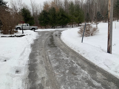
Parts of my St. Albans, Vermont driveway thawed today,
while other parts remained solidly frozen. A cold
rain tonight will likely add to the ice, despite
temperatures expected to be marginally above freezing

Forecast rainfall amounts have also ticked up since this morning. That makes me wonder whether power outages will be an issue in parts of eastern Vermont.  I don't think it will be anywhere near as extensive as during those awful wind storms on January 10 and 13. 

But a quarter inch of ice accumulation is where tree branches and power lines start to have trouble. Some areas in eastern Vermont will have that much. 

On the bright side, widespread power outages usually don't start happening unless there's more than a half inch of ice, and that isn't in the forecast through Thursday morning. 

In western Vermont, enough cold air might bleed in from the north tonight to make parts of Franklin County pretty icy.  Even if it stays above freezing, the rain will freeze on cold surfaces that aren't treated with salt. I'm talking back roads, driveways, sidewalks, that sort of thing.

I noticed today at my place in St Albans, Vermont, parts of my driveway thawed, while the ice has hung on stubbornly in other sections. We don't salt our driveway, because that would hurt the paws of Jackson the Weather Dog. My driveway is just an example of how things will play out tonight. 

THURSDAY 

Another lousy day in Vermont. The main batch of rain and freezing rain will move out by dawn or shortly thereafter.

That will leave us under a layer of low, thick clouds. We'll have areas of fog and patchy drizzle and freezing drizzle. If you have Seasonal Affective Disorder,  this will be another tough one. 

Especially since another round of rain and freezing rain will be on our doorstep. 

THURSDAY NIGHT/FRIDAY

That will come in overnight Thursday night and last well into Friday.  I suspect the freezing rain won't be quite as widespread as tonight but that's not a guarantee. I still worry about a few places that don't thaw out Thursday, then get more freezing rain Friday.

Friday will be another day of low clouds, fog, drizzle and light rain and/or freezing rain. In some placed all that will keep freezing.  Where it remains above freezing it'll only be in the mid 30s. That's quite warm for this time of year, but bone chilling given the fog and drizzle.

BEYOND FRIDAY

It'll stay mild Saturday and maybe into Sunday, but the clouds will hang tough. We're still watching yet another storm later Sunday. So far, it's still looking like that one will stay too far south to give us much precipitation. Even if it does, the atmosphere will have cooled enough to give us snow, not freezing rain. 

Cross your fingers but longer range forecasts indicate we just might have a quiet weather week next week. Sometimes boring weather is a good thing.  

Nice Snowy Part Of Vermont Storm Ending. Now For The Ice

Latest National Weather Service/South Burlington ice
forecast. Any shaded area can expect ice. Orange
represents at least a tenth of an inch of ice. Red
areas get a quarter inch of ice. A quarter inch of
ice accumulation is usually where you begin to
see some problems with tree branches and power lines.
 Just as expected, most of Vermont received one to three inches of snow overnight and early today, freshening things up and making it all look properly bright and wintry. 

Now for the extended messy part. I hope you like either freezing rain or a cold rain with temperatures in the 30s, because that's what we've got coming up for the next couple of days.

As I write this around 8 a.m. Wednesday, a lull was developing in the snow.  We'll just have flurries or maybe a patch or two of drizzle or freezing drizzle this afternoon, but nothing really to worry about.

ICY NIGHT

Then the next surge of precipitation comes in this evening and overnight. That's where the trouble begins. 

It looks like it will be just warm enough for a cold rain west of the Green Mountains except for maybe the far northern Champlain Valley.

But given the fact it's been nippy recently, that cold rain will still freeze on some surfaces, like back roads, driveways and sidewalks. So it won't necessarily be easy going in the "banana belt" either.

Along and east of the Green Mountains, and maybe the northern Champlain Valley from perhaps Georgia or St. Albans north, there will be freezing rain overnight. 

For the most part, it will not be heavy enough to weigh down trees and power lines so much that the electricity goes out. There might be an isolated issue with that here and there, but it won't be anything terrible.

What will be terrible are the roads overnight and early Thursday. It doesn't take much freezing rain at all to make the roads really hazardous. All it takes is a sprinkle of freezing rain. In the ice areas of Vermont, it's best to stay home overnight and Thursday morning if at all possible. 

It's no wonder there's a winter weather advisory up for the entire state. For western Vermont it expires by early afternoon today since most of the precipitation tonight should be rain. East of the Greens, the advisory goes to 7 a.m. Thursday

The hope is temperatures go above freezing for everybody Thursday afternoon to melt what's coming next. 

THURSDAY NIGHT/FRIDAY

It looks like a system similar to the one we're seeing tonight will come through Thursday night and Friday. 

Again, it looks like western Vermont will have another round of cold rain while eastern Vermont could see more freezing rain. 

I'm sure the National Weather Service in South Burlington will hoist another winter weather advisory for Thursday night. The won't' until the initial round tonight ends so as to avoid confusion. 

Not only will the roads be awful in the icy areas Thursday night and Friday, I'd begin to worry about power outages.

If tonight's ice doesn't melt off the trees and power lines Thursday afternoon, then a new dose of ice could start to cause somewhat more widespread issues with fallen branches and power lines.

That's by no means guaranteed, but it's something we'll have to watch.

Overall, that "fire hose" of moisture I described yesterday is more powerful further north than first thought. That plume of wet air is indeed causing a lot of flooding along the Gulf Coast.

Up here in Vermont, instead of a total of a quarter inch of melted snow, ice and rain between last night and Friday, most of us will see well over a half inch of melted precipitation, with many spots going to near an inch. 

Beyond that, a shot of colder air comes in Sunday.  There's wildly varying forecasts on whether one more storm near the East Coast will come close enough to Vermont to bring us another round of snow to start next week.

The good news is if we do see anything from that Sunday/Monday system, it would be snow, not ice. 

Monday, October 9, 2023

Most Widespread Frost So Far This Autumn In Vermont, Which Is REALLY NOT Saying Much

A ripe, ready to pick tomato in my St. Albans, Vermont
garden today. I picked more than half a dozen 
tomatoes just last Friday. Before this year, the latest
I ever picked a good, not frost-damaged tomato
was on October 1. 
 The National Weather Service has issued a frost advisory for large swaths of Vermont overnight and early Tuesday morning, the most widespread such alert yet this autumn.  

Which is wild, because the frost advisory is saying much, at least compared to an average autumn.

 Most of the Green Mountain State away from Lake Champlain should have had a killing freeze by now, if things were normal. But even as the trees go bare in preparation for winter, sensitive plants outdoors are still untouched, and in some cases thriving. 

The frost advisory, in effect from 2 to 8 a.m. Tuesday, covers central, eastern and southern Vermont. The Northeast Kingdom is exempt from the frost advisory, since their potential growing season is considered over.

However, most of that area of Vermont has very oddly not had a frost yet, so people are still probably hanging in there with sensitive outdoor plants in normally chilly towns like St. Johnsbury, Lyndonville and even sections of normally frigid Island Pond near the lake. 

Even in the Northeast Kingdom, it might be worth it to try to protect plants for a little while.

A frost advisory means temperatures could dip into the low and mid 30s, enough for patchy frost to develop. It doesn't have to get down to 32 degrees to get a frost, because temperatures on the ground are often colder than five feet off the surface, where temperature readings are usually taken.

A frost advisory isn't as dire as a freeze warning, which means temperatures are expected to get below 32 degrees and would really kill off outdoor plants. 

A freeze warning is NOT in the cards for tonight.

The first fall freeze of 2023 is already later than normal for almost all of Vermont.  Depending upon which central Vermont community you live in, on average you should have had the first 32 degree reading of the season sometime in the last week of September or the first couple days in October.

Burlington's average first autumn freeze is around October 8, so we're a little past that. Right along Lake Champlain, in places like South Hero, the average first freeze is around October 19.

It also looks like today's high temperature in Burlington will be below 60 degrees, the first time that's happened since May 17, when we had that unfortunate, and destructive late crop killing freeze.

I don't have specific record on this, but I'm pretty sure this is one of the latest if not THE latest first sub-60 high temperature on record. I've often seen highs in the 40s this time of year, so it has been consistently mild or warm, or even hot for early to mid autumn. 

To give you an idea of how cold it can be this time of year, at least in the past, on this date in 1979, the HIGH temperature in Burlington was 37 degrees, and we had 1.4 inches of snow that day. 

There might be more areas of frost Thursday night and Friday morning, but we still don't see evidence of a hard autumn freeze coming up anytime soon. Temperatures in Vermont should remain seasonably cool, but not at all unusually chilly for at least the next week. 

Wednesday, September 6, 2023

September Heat Grinds On, Will Eventually End With - Sigh - Heavy Downpours

 Oh, I'm such a naive boy.

My quick fire hydrangeas glowing in the hot 
evening sun Tuesday.  They've turned a russet color
which should be a sign that it's autumn. Sure doesn't feel 
like autumn this week! 
In the closing days of August I said to myself: "Thank goodness this disastrous, stormy, ridiculously humid, cloudy, smoky summer is about to end! September is coming. The month of blue, dry skies, air that's apple munching crisp, it'll give me so much new energy to get things done outdoors! " 

So much for that, huh?

Tuesday was about as miserable summer day as you can get. Oh, sure the sun was out almost all day, which would be nice if temperatures were reasonable. 

The sun was part of the problem. It helped the temperature soar to 90 degrees again. The humidity was completely ridiculous, there was absolutely no breeze to bring relief. And we have a couple more days of this crap to go through. 

Needless to say, the September outdoor projects I wanted to get a roaring start on in my St. Albans property have fallen by the wayside. Tuesday evening, I lasted a grand total of 42 minutes out there getting things supposedly done. Yeah, I haven't made much progress. 

I won't today, either. It will be a carbon copy of yesterday, with highs near 90, almost no wind and ridiculous humidity again.  

Burlington has this arbitrary rule that if you get three days or more of 90 degree temperatures, it's an official heat wave. Since we'll probably get to 90 today, this will become only the fifth September heat wave on record. (Reliable records go back to the 1880s).

Needless to say, the heat advisory remains in effect today for Vermont

We have a better shot today of reaching record highs, because the existing record highs for today are a little lower than in the past few days. To tie the record high for today, Burlington needs to reach 90 degrees and Montpelier has to get to 85 degrees. 

Tomorrow, we'll begin a weather transition that will potentially bring back another nightmare from this summer: Strong thunderstorms and torrential downpours. And yes, a low, but not zero possibility of flash floods. 

It'll probably get close to 90 degrees again on Thursday, but during the afternoon, scattered thunderstorms will develop in the humid air.  Some of those storms could have strong, gusty winds and those wicked downpours. 

The threat of flash flooding in Vermont has diminished some, since it hasn't really rained in a week. That's given the soils a chance to dry out somewhat. 

However, those potential torrential downpours Thursday could be gullywashers in a few spots, with the risk of urban flooding and isolated instances of more damage to roads, driveways, that sort off thing. 

This transition away from the heat wave will be painfully slow. And wet. Temperatures will be down to around 80 on Friday, but it still be wicked humid. More downpours are likely. We could have more of the same on Saturday, with a continued low but not zero risk of flash floods.

It really depends how much rain falls Thursday and Friday to determine how much flood risk there is on Saturday. Stay tuned. 

Even Sunday looks showery at this point, but blessedly cooler. 

Forecasters are still insisting we'll have much less humid air by the time next week starts, with temperatures down around normal.  Normal highs this time of year are in the upper 60s to mid 70s. If that pans out, it will be nice! 

Monday, September 4, 2023

Vermont Heat Update: It Intensifies Today And Tomorrow, Peaks Wednesday

The hibiscus on our back deck is certainly welcoming the
hot, humid weather with lots of new blooms, even if
I can't quite muster as much enthusiasm for the hot spell.
 The temperature got up to 84 degrees on Sunday in Burlington, Vermont, which actually isn't all that remarkable for early September. 

What is remarkable is that it was the hottest temperature since July 28.   As mentioned in a previous post, we had the coolest high August maximum high temperature since 1927.

We're more than making up for it this week.  It should get into the low 90s on many valley floors sometime this week. There's even a shot at an "official" heat wave in Burlington, which is three consecutive days of 90 plus temperatures. 

That's a pretty arbitrary definition of a heat wave, but it is what it is. 

Anyway, it's going to be an uncomfortable week. 

A heat advisory is in effect today in the Champlain Valley. That the heat index, which takes into consideration actual temperatures combined with humidity, could make it feel as hot as 95 degrees. 

Today won't even be the hottest of this toasty stretch. I doubt many places will make it to 90 today. There's a better chance of it getting past 90 degrees tomorrow and the day after. I'm pretty sure the National Weather Service will also issue heat advisories Tuesday, Wednesday and possibly Thursday as well. 

With the humidity in place, nights won't cool off very much either. Dawn this morning wasn't too terrible, as it had gotten into the low 60s.  The next few nights will only go down to 70 or so in the warmer valleys, so we won't be able to recover from the day's heat so well going forward.

A heat wave gets dangerous cumulatively. The longer it stays hot, the more a person's body is stressed. People who are vulnerable to heat, especially those who already have underlying health issues, need to be careful.

If you know an elderly or person with health issues, check up on them this week.  If their house is hot, consider taking them out on an air conditioned trip if they're up for it. Meanwhile, everyone should stay hydrated.

If you need to do strenuous work, try to do it early in the morning when it's a bit cooler.

As mentioned yesterday, we'll have to watch the schools, too, since most aren't geared up for heat waves.  Traditionally, we didn't often have heat waves during the school season, but that seems to be changing. 

The heat dome over us should begin to break down Thursday, but it will be a slow process. Thursday will continue to be humid and very warm.  Whether it gets to 90 degrees or not then depends on the timing of any clouds and showers that work their way in. 

Longer range forecasts call for a sluggish weather pattern, with things not moving west to east as quickly as they should. 

With all the humidity lingering, that could set us up for - UGH! more heavy rain toward the end of the week. 

The good news is the flood risk is diminished some because for the first time since early June, we will have had a week or so of dry weather. So the soils will be able to absorb a little more rain water than they did in July and August.

Still, we'll have to watch later in the week in case enough rain does fall to cause local flood issues. We have a lot of time to monitor that. 

At least we won't have any tropical storms or hurricanes in the mix to make any late week rain worse. The Atlantic Ocean remains abuzz with tropical storms and wannabe hurricanes, but I don't see any real threat to the United States coasts for at least a week.  

Meanwhile, very long range forecasts have shifted.

Those predictions reaching into mid month had been indicating continued warmer than normal temperatures past September 15. Now, those forecasts hint at cooler than normal weather toward the middle of the month.

That's no guarantee, since forecasts that far out aren't necessarily accurate. But if it pans out, it will be a shock to the system again. Cooler than normal weather in mid-September is much different that slightly chillier than normal air in mid-summer.

If it gets cool in mid-September, you'll know for sure it's autumn. For now though, enjoy or endure a very, very belated summer heat wave


Wednesday, February 8, 2023

Strange Quick Storm Last Evening, Bit Of A Mess Coming Thursday

 That band of wintry weather that zipped through much of Vermont last evening didn't last long, and didn't leave much behind, but it made for quite a noisy half hour. 

As expected, the weather disturbance contained a bout of mixed precipitation. It didn't amount to much and just slickened up the roads a bit. But boy, was it noisy, at least in the Champlain Valley.

Winds really ramped up during the brief interluded of storminess around 6 p.m. Winds in Burlington momentarily gusted to 50 mph.  Combined with a blast of sleet, most of us certainly heard it. 

Between a brief storm last evening, and a somewhat messy 
one tomorrow, Wednesday was lovely for February.
Temperatures reached the low 40s, a little snow melted.
and the sun made a welcome appearance. 
A little video at the bottom of this post illustrates a bit how loud it was in St. Albans, Vermont. 

The whole thing blew through within a half hour, leaving behind little except patches of drizzle, with a few patches of freezing drizzle in the cold spots.
 

Today has been quiet, and actually quite nice by afternoon. The sun came out, and many of us made it up into the low 40s. Some of the snow melted. It was a lovely March day. But in February.

Surprisingly, at least for me, the high of 44 degrees in Burlington was the warmest temperature since January 6. Seems strange given the balmy winter we've had. 

However, we're gearing up for a new storm. This one on Thursday and Thursday night will have more precipitation with it, and will definitely last longer than Tuesday evening's little outburst. 

A winter weather advisory has been posted for the entire spine of the Green Mountains of Vermont and  the eastern slopes of those mountains, and in the Northeast Kingdom 

It'll be tricky tomorrow afternoon as to who gets freezing rain and who just gets a cold rain. The Champlain Valley will be open for business to a south wind, so temperatures there should be above freezing all day. I wouldn't worry too much about freezing rain there.  

Along and east of the Green Mountains, it will depend on whether those south winds can scour down to the surface. Where those south winds hit, you should be OK. In protected valleys, the freezing rain might continue all afternoon.

That's tricky for motorists. You might be in a spot with just plain rain. Then you drive downhill and all of a sudden you're skating on ice. 

Ice accumulation forecast for Thursday. Most of the problems
in Vermont will be along and east of the Green Mountains. 

By the time Thursday night rolls around, though, most if not all places in Vermont should have warmed up enough to see plain rain. 

It could get noisy again, especially in the northern Champlain Valley, where winds could gust to 40 mph again Thursday night. 

As a cold front comes through, gusty winds will come in from the west. 

In one respect, Friday might end up being similar to last Friday, in that temperatures will probably fall all day. 

 Unlike last Friday, cold is a relative term.  We'll start off in the 40s, go through the 30s and into the 20s later in the day. That's above zero, not below. No Arctic outbreak this time! 

We might see some snow showers and light accumulation Friday and Friday night, so watch out for that if you're driving. 

From this vantage point, it looks like it'll be a quiet weekend.  Saturday will be seasonably cold  with temperatures in the 20s during the day. Another warmup will start Sunday, with highs in the mid and upper 30s, much like last Sunday. 

Video: It's night but hard to see, but volume up.  A half-hour long interlude of high winds and sleet last evening in St. Albans made for a noisy dinner hour. Click on this link to view, or if you see the image below, click on that: