Showing posts with label emergencies. Show all posts

Saturday, July 12, 2025

U.S. Summer Of Flash Flood Roars On, Flash Flood "Emergencies" Soar; Vermont On Guard For More Potential Trouble

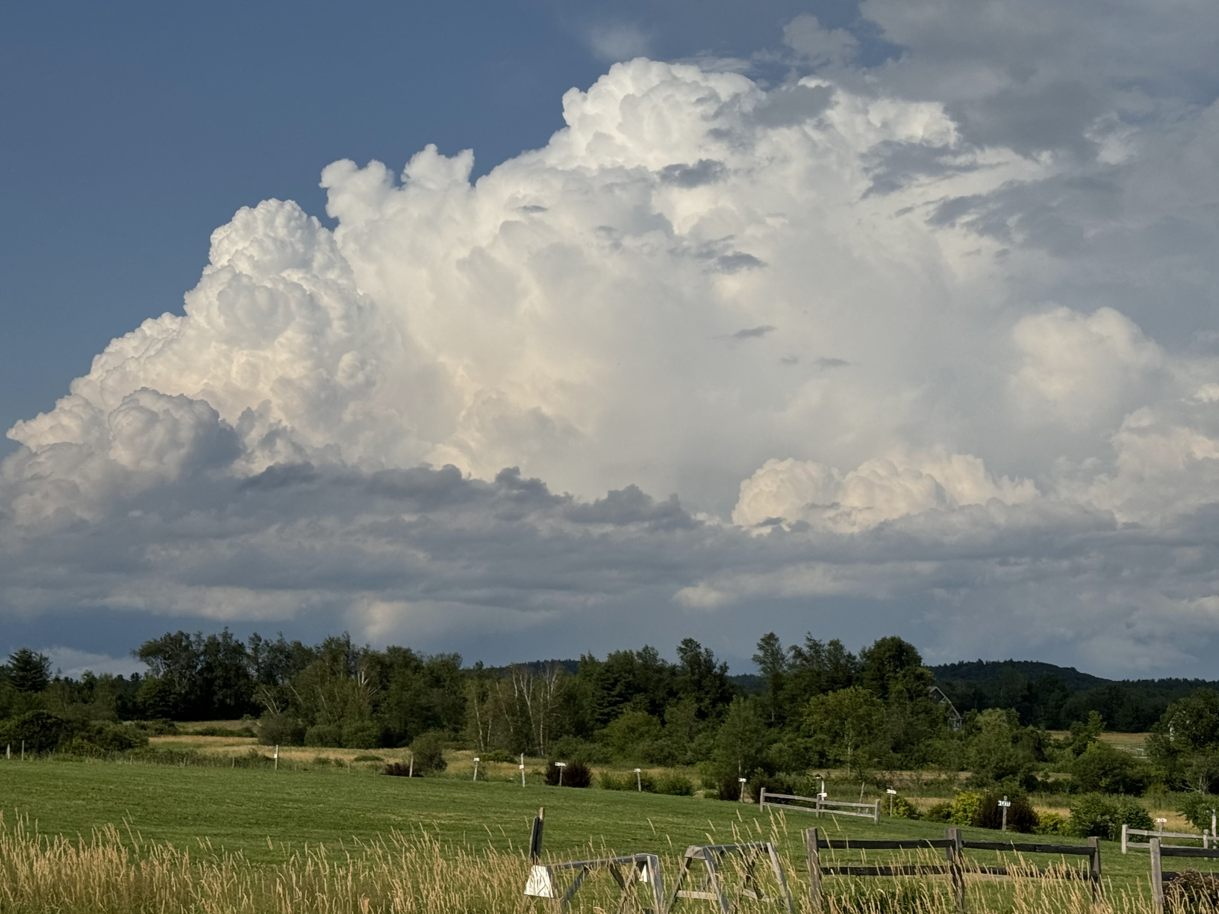
A large severe-warned storm erupts over the northern
Green Mountains on Thursday. If this type of storm
moves slowly enough, flash floods can develop.
There is a minimal risk of flash floods today
and some risk Sunday night and Monday in Vermont. 
Weather alerts that are worded as as "flash flood emergencies" are rare, accounting for maybe one percent of all flash flood warnings. 

All flash floods are dangerous, but when you hear "flash flood emergency" you know you are in deep trouble - and probably deep water. 

When the National Weather Service issues a flash flood emergency, it's a dire warning telling the public that a catastrophic flood with an extreme threat to life and property is either ongoing or about to happen any minute. 

As extreme rains ramp up, in large part due to climate change, those flash flood emergencies are increasing. There were at least 91 such emergencies in 2024, a record high. 

Vermont is not immune from these emergencies. One was declare in the Northeast Kingdom during the July 30, 2024 floods up there. Emergencies were declared in Vermont in the July, 2023 floods as well. No flash flood emergencies were declared in the Northeast Kingdom flash flooding we had this week. 

We don't have figures for this year, but flash flood emergencies have been declared incredibly frequently in recent weeks. Such an emergency was declared in central Texas for the extreme and deadly July 4 weekend floods there. Another flash flood emergency was declared in Ruidoso, New Mexico on Tuesday as walls of water rushed down from wildfire burn scars above town. 

Just yesterday, another flash flood emergency was declared in and around Davenport, Iowa as intense rains flooded streets, homes and businesses there. 

Expect more of this. A humid air mass has enveloped most of the eastern half to two thirds of the United States. Dew points are practically off the charts in some spots. Any little weather disturbance can touch off a big local flood, especially since there's no large scale storms or fronts to move things along. Things are just sitting there. 

Today, huge parts of Texas, New Mexico and Oklahoma are especially prone to flash flooding. In some places in that broad area, significant, big flash floods are possible today. 

VERMONT RISK

Here in Vermont, we're relatively safe, but definitely not off the hook. With high humidity in place and not much wind to move the inevitable thunderstorms around, there's always the risk of a local flood problem. 

This is going to seem like a broken record until the very humid weather pattern breaks down. We've had hotter, more humid summers lately, and that increases the flash flood risk.

You'll probably get sick of me telling you almost daily about a low but real flash flood risk. But it's unavoidable. And of course, we have to stay on our toes with these things. We'll just keep up with the details each day as forecasts develop,

Today

There's a very low but not zero chance of a local problem today, especially in southern Vermont, where thunderstorms might be a little more numerous this afternoon and evening than in the north.  All of Vermont is under a marginal risk for flash floods today, the lowest of four alert levels. 

There's already been a couple isolated storms here and there early today. A flood advisory was in effect early in the day for the northwest corner of New Hampshire near the Vermont border because of overnight storms. A complex of storms, which seemed to be weakening as of 7 a.m. was approach southwest Vermont from New York State. 

Storms will redevelop in hit and miss fashion this afternoon. 

Many places won't see any rain at all, but a few rogue thunderstorms could sit and dump an enormous rain in a short amount of time in one or two spots. That's where you get your isolated flood problems. 

Meanwhile, highs will get well into the 80s to near 90. The 90 degree readings will hit in broader valleys that either don't see a thunderstorm at all or, ,the showers hold off until late in the day. 

Sunday/Monday

The heat and humidity goes on Sunday, with very humid air and highs once again reaching the 80s to near 90.

A couple random thunderstorms could erupt any time Sunday, but most will hold off until Sunday night and Monday. 

We're watching late Sunday into Monday closely.  A weak weather front will slowly approach and then begrudgingly limp through Vermont overnight Sunday and during the day Monday. 

Moisture should really pool ahead of this front, providing a lot of fuel for showers and thunderstorms. With all that wet air, and storms sluggishly moving parallel to the front, we could see some more spot problems with downpours bad enough to once again touch off a few local flash flood problems. 

This is one to watch for future updates. If things speed up, then that reduces the problems. If the front stalls over us, or just barely to the west, that could set off heavier rain.

We're up against another hot, humid week coming up, which means more scattered storms. The approach of a cold front Thursday or Friday will probably grow more storms, so that's the time period to be on alert again after Monday.  

Sunday, September 15, 2024

WaPo: Facebook Deleting Wildfire Warnings In Tinder Dry West

Something is going on with Facebook that is removing
emergency information near disasters from the platform
as misleading spam. 
 Apparently, Facebook doesn't want people in the wildfire -prone west from receiving potentially life-saving fire information on the social media site.   

As the Washington Post reports: 

"During a scorching relentless wildfire season, Facebook has been flagging and removing dozens of posts containing links and screenshots from Watch Duty, a widely relied-upon wildfire alert app, as well as from federal and state agencies, according to interviews and Facebook conversations with nearly 20 residents, Facebook users and moderators, as well as employees from disaster response organizations."

Where this is happening, Facebook tells users they violated the "Community Standards on Spam" due to trying to get likes, follows shares or views in a "misleading way."

WaPo said it happens mostly with links including to official and reputable from Cal Fire, The U.S Forest Service, various sheriff's departments and AlertCalifornia, which monitors fires and other disasters in real time. 

The problem extends to other areas. Facebook removed emergency information on Hurricane Debby in Florida back in August. 

The problem seems to have developed, or at least intensified, back in June when something on Facebook changed, reports WaPo. Since then, emergency information has been disappearing as fast ast it's posted, it seems. 

I want to be charitable and say something is screwy with Facebook's algorithms or some damn thing. My conspiracy minded brain almost wants to think that accurate emergency information isn't a money maker.  After all, what makes money is engagement. Facebook and other social media platforms want controversy and argument as that brings in the revenue.

 Perhaps helpful information doesn't make people angry enough to "engage." 

It's interesting that there's so much spam and junk of Facebook, but this useful information during emergencies is being down. 

For their part, a Facebook spokesperson said the company is "investigating this issue and working quickly to address it."  Facebook said it was not aware of the problem until the Washington Post contacted them. 

Which might be a stretch, since people and organizations whose posts have been removed have been complaining of Facebook since June. Most of those people have never heard back from Facebook. 

Even when and if everything is working as it should, Facebook isn't necessarily the best place to seek emergency information during a disaster. But the social media platform is, as the Washington Post says, familiar, accessible and hyper-localized. It's a place where people can share information on evacuation orders, where shelters are, how to get meals, help for pets and to find missing relatives and friends. 

And let's face it: Facebook is the go-to for many people who are older or not especially tech-savvy.

Complicating the issue more is Facebook doesn't notify people if their posts have been taken down, so they're blissfully unaware. Also, people are now avoiding posting what could be valuable information because if there's too many supposed "violations," Facebook might entirely shut down the page permanently. 

I do hope this is just a problem with dumb algorithms and Facebook straightens it out quickly. I also hope WaPo follows up on this. 


Sunday, July 16, 2023

Chaotic Day Eastern New England, Vigilance In Vermont

UPDATE: 10:15:

I spoke too soon. Just after I posted this, the first flash flood warning of the day was posted in part of north central Vermont. Watch out in areas like Morrisville, Stowe, Worcester, Eden. 

I'm sure more flash flood warning are coming. This is just the start.

PREVIOUS DISCUSSION

It's already a wild day in eastern New England, especially in New Hampshire, where numerous flash flood warnings are in effect, there's also a tornado watch for that state and rest of eastern New England, and I've seen at least one tornado warning on the New Hampshire/Massachusetts border.  
Lots of warnings today in Northeast. 
Green is flood watch, yellow is tornado watch,
dark red is flash flood warning, and hard to see,
but bright red is tornado warning. That
grey in the Midwest is this summer's 
ever-present wildfire smoke. Ugh. 


In Vermont, it's so far quite a bit quieter, but everybody is still on a high state of alert for possible new flooding today. I'll get to that in a minute.

But first, our eastern and southern neighbors:

WEEKEND IN NEW ENGLAND

Today is not the peaceful stuff of that old Barry Manilow song. that's for sure. All of southern New Hampshire was under a flash flood warning as of 9:15 this morning.  Rainfall rates of two to three inches per hour were reported.

Western Connecticut if under a flash flood warning, too. I've seen photos on social media of water rescues from flooded homes in and around Waterbury. Connecticut

Additional thunderstorms should last most of the day in central and southern New England and on into New Hampshire.  Some areas win this danger zone could see four to six inches of rain today, with possibly higher amounts. 

The heavy rain will be in streaks, where storms train, or line up like box cars. There will be some towns that get six inches of rain and terrible flash flooding, while communities a few miles to the northwest or southeast just see a couple inches. 

To make matters worse, there's enough spin the air in southern New England, southern and central New Hampshire and southwestern Maine to raise the risk of tornadoes through this morning and early afternoon.).


More spinups were showing up on radar in central Massachusetts as of 10 a.m. 

VERMONT VIGILANCE

We're not out of the woods. As of 9:30 a.m. locally heavy rain was reported in parts of the state, especially east of the Green Mountains.  So far, it hasn't been enough to create any reported new floods, but the alert is up. Way up. 

All of Vermont except the immediate Champlain Valley remains under a flood watch today.  Local flash floods could happen anywhere in the state today, but seem most likely along and east of the Green Mountains. 

This first batch was still crossing Vermont as of 10 a.m, but was looking like it would at least temporarily need soon in western parts of the state.

There are embedded areas with rainfall rates of more than one inch an hour. That's more than enough to set off some flash flooding as early as within the next couple of hours in parts of the state.

After this first area of rain mostly moves out of Vermont by noon or a little after, we're not done. 

New thunderstorms will develop this afternoon.  They will be somewhat hit and miss, but potent in terms of rainfall.  The air is as humid as it can possibly get this far north. It's basically like Florida. 

There is so much water available for torrential downpours. Any of these storms can produce flash flooding. The ground is so saturated that pretty much anything that falls will run off.  It's hard to say who will get a new flash flood in Vermont today, but someone will. That's almost a guarantee.

Main stem rivers will be more behaved than last week. However, some like the Otter Creek and Winooski River will probably reach flood stage.  

It won't be as bad as the  historic floods of last week, and downtown Montpelier is still looking safe from a new inundation. 

As for the tornado threat, I suppose there's a non-zero chance in far southeastern parts of the state, but it's unlikely. We had our own tornado up in Benson and Sudbury Thursday, so don't feel left out.

One or two of the storms this afternoon could produce a microburst, which would mean severe winds in a couple of spots, but that is fairly low and pretty isolated. 

I'll have updates later today as warranted. This is just a quick overview to get you started this mid morning Sunday.