Showing posts with label road closures. Show all posts

Thursday, July 11, 2024

Another Big Flood Disaster Crushes Swaths Of Vermont

Photo of Bridge Street in Richmond this morning taken
by Joanna Berk, via Facebook. Very sadly, I was
able to take the exact same flood photo last July 11 
and last December 19. The latest flooding seems
to have cruelly victimized the same people hurt
by last year's flooding. 
UPDATES 9 AM

A couple things coming in since I wrote this:

The Lamoille River at Johnson, and presumably later in Cambridge, is rising faster and higher than expected.

At Johnson, it should have peaked by now, but is now rising toward major flood stage at Johnson this morning and early afternoon.

The flood forecast for that river keeps increasing, so the Lamoille River Valley appears to be in trouble again, unfortunately.

Also, the news and photos  out of Plainfield are downright scary. You see that photo of the large house down below in this post?  

Turns out half of it is missing. There were five apartments on the rear of the building that were swept away, reports WPTZ.  Last report is everybody got out so somehow, there were no fatalities with that. Other buildings in Plainfield were knocked off foundations, undermined or badly flooded. Plainfield appears to be the hardest hit town, or at least close to it.

Vermont Gov. Phil Scott is scheduled to give a press briefing on the flooding at 10 a.m. 

Updated rainfall totals include 6.76 inches at Hinesburg, 5.79 inches in Richmond and 5.5 inches in North Fayston. There are many reports of four to five inches of rain. Remember, this all fell in less than 12 hours, which helps explain the intensity of the flash flooding. 

 PREVIOUS DISCUSSION

 It's deja vu all over again, as the saying goes.  

For the second July 11 in a row, I woke up this morning to dreadful Vermont flood news.

Our latest flood last night was bad. Really bad. And it victimized many of the same people it hit last July. This particular flash flood seemed to cruelly focus on the same areas hit hardest last July

A swath through central and northeastern Vermont has taken the brunt of the storm, with many homes and businesses seriously damaged again, many roads closed, people evacuated and lives upended.

Downtown Barre flooded again, with torrents of water rushing down its streets and Vermont National Guard members frantically evacuating people again.  I honestly don't know how Barre will recover from two devastating floods in one year. 

Downtown Montpelier was spared, thank goodness. But I can't say the same for places downstream in Waterbury, Richmond, Williston.  The river was just shy of major flood stage.  The Winooski River water is now racing toward Burlington's Intervale, where all those wonderful vegetable farms are about to be ruined again. 

The flash flooding really smashed through places along small creeks and brooks.  An image on Facebook showed railroad tracks suspended in the air, washed out by Joiner Brook in Bolton. The Bolton Access Road is trashed by the same brook.

Dozens of roads are closed this morning in Vermont, all under water or washed out.  Reports are still coming in, so I don't know if any one was injured or God forbid killed. Last night was a dangerous one, so I've got my fingers crossed.

Damage videos are already popping up, and they're not good. The Passumpsic River in Lyndon forced the evacuation of a mobile home park, and one of the town's famed covered bridges had water hitting the bottom of it by 6:30 a.m. 

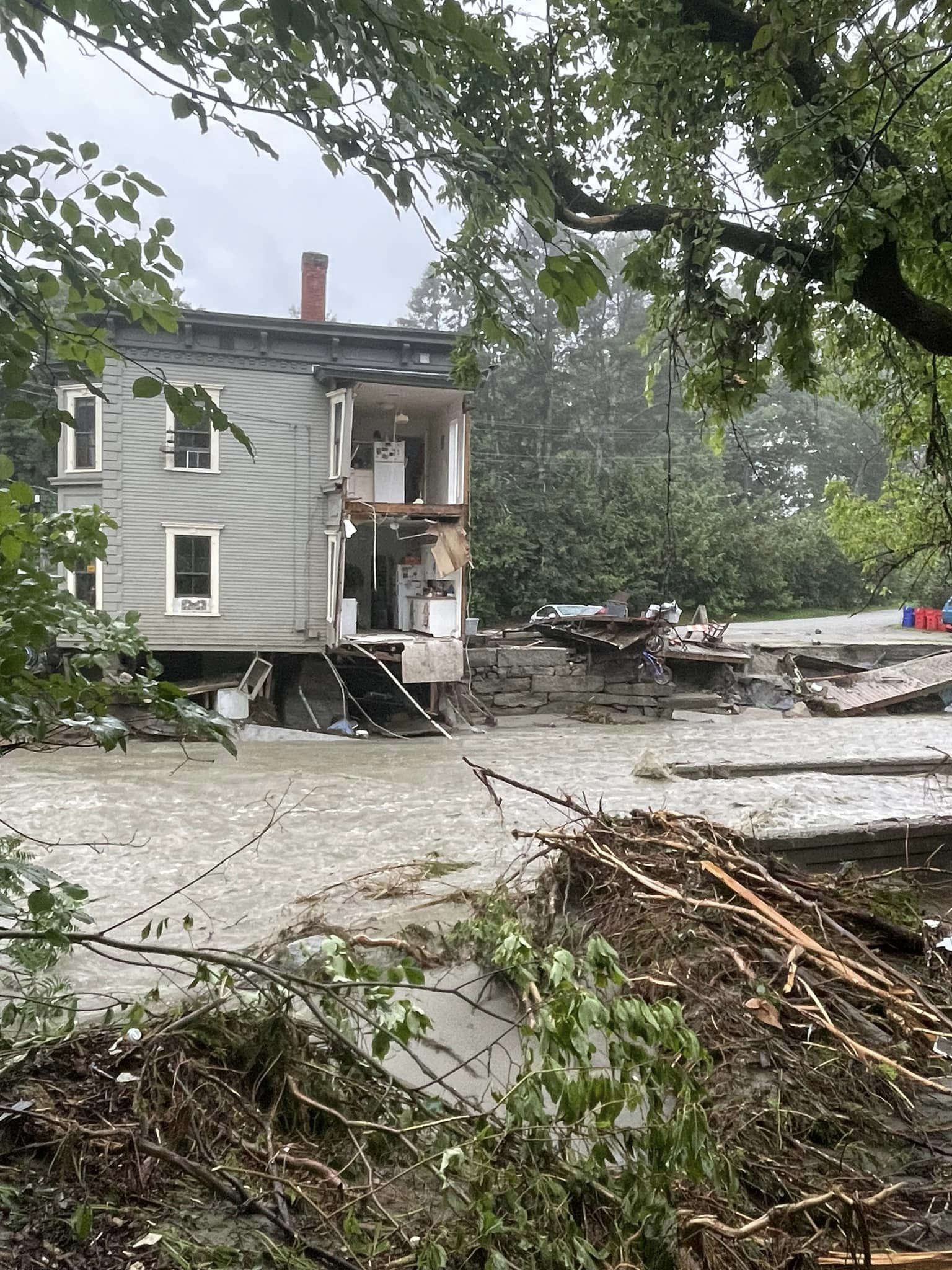
Video posted to Facebook shows extreme destruction in Plainfield with a road missing and a large old home partly collapsed into a river. The rest of the house appeared badly undermined and might also collapse. 

Anna Guber of WPTZ posted this 
photo of destruction in Plainfield, Vermont.

In Stowe, some roads that were wrecked by flash floods less than two weeks ago were trashed again. 

As I write this, there's too many road closures, incidents of damage, evacuations and updates to exhaustively list here. 

Suffice it to say, though, that getting around this morning in central and northeastern Vermont, from Addison County on through Barre/Montpelier and up the Route 2 corridor to St. Johnsbury and beyond will be difficult. 

You'll need to be patient today, as there will be a lot of detours or places you just can't go. 

FORECAST

Today will gradually transition from hasty evacuations to sad cleanup. 

A little more rain is in the forecast, but it won't really be enough to cause more flooding. A few local downpours might undo some of the repairs in one or two spots, but this won't be widespread.

The danger today and going forward into the weekend is the warm and humid weather that will keep harassing us. The temptation among us Vermonters is to work hard, get things done, help our neighbors. But there's a real risk of heat exhaustion or worse.

Although some of you will be tempted to keep working, don't. You need to take frequent breaks. And hydrate. I'm sure volunteers will bring plenty of water, sports drinks, snacks etc. to help with the effort. Take full advantage of that. 

I'll of course have more on this latest disaster as we go through the day.

For now, I agree, it is depressing to wake up to another morning like this. They've been all too frequent. We'd been warned that climate change would make these kinds of floods more frequent as rainfall gets heavier.

Some reports coming in suggest pretty extreme rainfall. Hinesburg reported 6.57 inches. St. Johnsbury and Monkton came in with around five inches. You get the idea.

 Gosh, I hope this is the last one for quite awhile. We've had more than our fair share. Unfortunately, though, you never know, which is what makes all this unsettling. 

Tuesday, March 14, 2023

Tuesday Evening Vermont Snow Update: This Huge Winter Storm Confounded Meteorologists

Cars having a hard time negotiating the hill near my
house on Fairfield Hill Road in St. Albans during heavy 
snow early this afternoon.
 The over-performing winter storm in Vermont continued to pull surprises this afternoon in Vermont, dumping more unexpected snow on the Champlain Valley and racking up accumulations in southern Vermont that outdid even some of the more wild-eyed forecasts. 

This had to be one of the most poorly forecast winter storms I've experience in Vermont. 

This is NOT a diss at the meteorologists who tried to forecast it. The storm had all kinds of weird aspects, did weird things and is following a weird path that makes forecasting the damn thing impossible. 

Given the strength and surprises from this storm, problems continued to accumulate all day, almost as fast as the snow. 

Reports continued to come in all day of roads blocked by fallen trees, power lines and branches. 

Power outages peaked at about 38,000 in Vermont around noon before leveling off at around 31,000 for most of the afternoon. That's a lot! 

There were vehicle crashes too. Vermont State Police reported responding to 106 crashes through 3 p.m. today, but so far only three injuries have been reported.

Among the scariest was in Richmond, where a motorist lost control on a slushy road and sideswiped a school bus, causing quite a bit of damage to both vehicles. Luckily, none of the kids on the bus were hurt. The drivers are OK, too.

Meteorologists did get some things right. Yes, more snow fell on some parts of the south than forecast. However, forecasters had warned us for days that the mountains of southern Vermont would be in trouble with deep, heavy, wet snow that would screw around with power lines, and that certainly happened. 

Snow totals continue to impress. The most I've seen so far is an astounding 32.4 inches in Marlboro, Vermont, 28 inches in Wilmington and 27.3 inches in Readsboro.  

Accumulations were just slightly more than expected in central Vermont, amounting to 8 to 12 inches. A little more than that fell in high elevations and a little less in the lowest, warmest valleys.

Northern Vermont continued to way over-perform. Here in St. Albans, forecast accumulations in forecasts from Saturday through Monday ranged from 1.4 to 2.9 inches. When the snow finally tapered off (at least for now) at around 4 p.m. a full 8.0 inches of snow had accumulated. 

Most of northern Vermont has had 6 to 10 inches so far. 

As everybody understands, the snow is wet and heavy.  There's a TON of water in it. 

Pine trees bend under the weight of heavy, wet snow
today in St. Albans, Vermont. 

Here's one way to illustrate it. Today is the sixth anniversary of the infamous Pi Day Blizzard on March 14, 2017. In that storm, Burlington received 30.4 inches of snow. It was cold that day, so the snow wasn't like wet cement. If you melted that snow down, you got 1.13 inches of "rain."

Today, Burlington received about eight inches of snow. If you melt it down, you get just under an inch of rain. The Burlington area might end up getting just a third the amount of snow in the Pi Day blizzard, but at least as much liquid equivalent.  I'm sure some higher elevations, especially in southern Vermont, have already received the equivalent of more than two inches of rain. 

BOTCHED FORECAST

So what went wrong with the forecasts? Especially in northern Vermont.

According to the National Weather Service office in South Burlington, the thinking before the storm was that dry air coming in from the northeast would hinder the intensity of the snowfall in the northern half of Vermont. 

Since the snow would be light, the strong March sun would send some heat through the clouds, and any snow that fell in the valleys would have a hard time accumulating. It would essentially be a white rain of sorts. Forecasters knew higher elevations would get a decent amount. 

What happened instead was an initial storm near Long Island was supposed to weaken quickly in favor of a much stronger storm that would move northwestward from way offshore and move to near Boston this afternoon. 

That second stronger storm acted pretty much as expected, but that Long Island storm hung on longer than forecast. That storm sent what was essentially a weather front that moved slowly northwestward across the entire state of Vermont. 

Snowfall rates were intense in that band, up to three inches per hour. The March sun became a non-entity under that slowly moving snow band, so the slushy stuff really piled up. 

The expected drier air did eventually make it into north central and northeastern Vermont, so only light snow fell there this afternoon. 

But that weather front of sorts stalled in the Champlain Valley, keeping the heavy show going. 

Finally, at around 4 p.m., the drier air from the northeast finally punched into the Champlain Valley, largely shutting down the snow. For now.  

WHAT'S NEXT

You might be forgiven if you don't believe the forecast going forward tonight into tomorrow, but we'll give it a shot. 

It's mostly just flurries in northern Vermont, with a few patches of somewhat heavier snow as of 4:30 today. That will last a little while longer, but the snow will fill back in.

And it will snow most of the night. It shouldn't come down nearly as hard as it did today, but still, two to locally six inches of added snow with up to eight new inches in the northern and central Vermont mountains seems like a reasonable forecast. 

I will note I'm a little suspicious of a somewhat heavier band of snow that set up late this afternoon across central Vermont, but I don't know if that's a passing fancy or is it something that will bring another surprise. 

Winds have been gusty at times and that will get worse tonight and tomorrow. Later tonight, as temperatures drop, the snow that's falling should become a little less like wet cement and a little more powdery. So there will be issues with blowing and drifting snow, especially in open areas. 

Down in the buried areas of far southern Vermont, another four to eight inches of snow tonight should add to the crushing piles of snow on the ground down there. 

Snow will taper off and in many places end on Wednesday. But it will be by no means a nice day. North winds should gust to 35 mph with possible gusts to 45 mph in the Champlain Valley. That could take down more snow-laden trees, and at the very least making life much more difficult for the crews who will surely be continuing to repair all those downed power lines.

Temperatures should stay near or a little below freezing all day Wednesday. 

The next storm on Friday and Saturday still looks like it will be mostly rain. Which will make a mess of the snow but shouldn't add on too many additional problems. It won't rain hard enough and not enough snow will melt to produce any real flooding. 


Early Afternoon Vermont Storm Update: It's Still Really Over-Performing

Snowfall and road conditions definitely worse than 
expected around noon today near my place in 
St. Albans, Vermont. 
 Today's snowstorm continues to be more brutal in Vermont than most forecasts had suggested as early as last evening. The forecast in far northern Vermont, in particular, was a big bust, with much more snow than originally expected. 

As of 12:15 p.m., more 36,700 homes and businesses were without power across Vermont. That number kept going up and up all morning. 

I've seen numerous reports of sections of roads closed, mostly in southern Vermont, due to tree and power lines falling into roadways. Stay off the roads in southern parts of the state, and in high elevations of central and northern Vermont today. 

Snow totals are impressive in far southern Vermont, and they're not even done with this storm yet. The top totals as of noon included 24.5 inches in Readsboro, and a little over 21 inches in Windham, West Brattleboro and Marlboro. Weston reported 18 inches.

In the north, not as much snow has fallen, but still more than originally forecast. Totals include 14.5 inches in Northfield and 10 inches in Morrisville. 

Even up here in St. Albans, which was supposed to be spared much accumulation, we had 4.4  inches of new snow as of 12:45 p.m. 

Part of the culprit with both the high snow accumulations and power outages and was a band of intense, wet, heavy snow that moves slowly northwestward across the state this morning. Snowfall rates were two to three inches within this band. 

The unexpected strength of this band forced the National Weather Service to extend the winter storm warning to the Canadian border, including in the Champlain Valley. An additional three to five inches of snow is possible in places like Burlington and St. Albans, for a storm total expected to reach four to 10 inches. 

Accumulations will be greater than that in the higher elevations.

This band of snow began to fade a bit as it reached Lake Champlain and northeastern New York early this afternoon, but the damage in Vermont was done. 

Web cam grab of Interstate 89 in Waterbury, Vermont as
a heavy snow band passed through late this morning. 

The intense snow band also delayed an expected break in the storm in northern Vermont. But it's finally arriving. 

As a punch of dry air gets ingested into the storm, snow had become lighter in northeastern and north central Vermont.  The snow might even stop for a time before resuming later today. The lighter trend in the snowfall will probably reach the Champlain Valley for a while this afternoon, too. 

In northern areas, some valleys will get a little warmer during the break, which might give overloaded trees and wires a break through melting. Higher elevations, though, will continue to deal with this type of problem. 

The snow will start up again later today in the north.  It might not be as intense as it was this morning. But with falling temperatures and gusty winds this evening and tonight, things will remain challenging out there. 

The dry air isn't really reaching southern Vermont, so the snow will continue there today and tonight. Some favored higher terrain down there could see more than 30 inches of snow. It's beginning to look like those snowed-in areas of mountainous California down there. 

Power outages will continue all day, especially in southern Vermont. It's getting gusty out there, and the wind, if anything will increase. 

Snow will become less intense later tonight even in the south, and slowly taper off tomorrow. 

We're not done with this one yet. Buckle up, it's going to be a pretty stormy afternoon and evening, especially in southern Vermont.