 |
| Almost two feet of rain in half a day around Fort Lauderdale, Florida Wednesday caused serious flooding, as you'd imagine. |
One was just insane rains right around Fort Lauderdale, Florida, and the other was a massive forest fire in New Jersey. Let's do the flood first, then the fire.
FORT LAUDERDALE
Rainfall was insane, to say the least. The Fort Lauderdale airport received a whopping 22.5 inches of rain in just seven hours.
That's about a third of a normal year's rainfall in the city. Normal rainfall for the entire month of April there is about three inches. It's possible Fort Lauderdale received more rain in half a day than the previous record for wettest entire month.
That will have to be looked into to confirm.
Not surprisingly, the Fort Lauderdale area was under a flash flood emergency. Everything was flooded, including parts of the tarmac and the roads leading to the Fort Lauderdale-Hollywood International Airport.
The airport shut down and probably won't reopen until at least noon today. Broward County schools are also closed today. Most streets were flooded yesterday, and it will take time for the water to drain.
While all of South Florida had rain and thunderstorms on Wednesday, intense storms stalled around Fort Lauderdale. You can see in this radar loop on a Twitter post from @weathertrackus how persistent the storms were in just one area.
The storm was highly localized. Miami, just 30 miles away from Fort Lauderdale, only received 2.15 inches of rain, though it was that city's third day in a row with more than two inches of rain, with a three-day total of 7.38 inches.
As the Washington Post explained, a warm front stalled near Fort Lauderdale, causing moisture to sweep in from the Atlantic and converge over the region. The air was as saturated as it can get. The converging winds and a general atmosphere that supported updrafts for thunderstorms resulted in the torrential rains.
Had the warm front been moving, the heavy rain would not have lasted that long in any particular spot. But since it stalled, the rain unleashed its fury on Fort Lauderdale.
Heavy rain is possible in South Florida today, but less likely than it was yesterday.
NEW JERSEY FIRE
 |
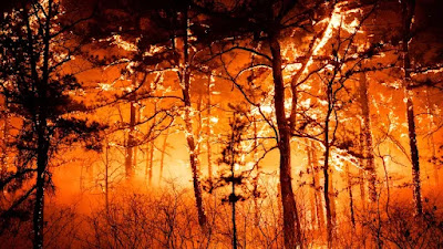
| Extreme wildfire in New Jersey Monday and Tuesday. |
But a blaze near Manchester Center and Lakehurst, New Jersey this week has been off the charts.
The fire tore through the crowns of trees in forests, something you almost never see in the East. It looked like one of those gigantic wildfires in California in recent years.
"New Jersey Department of Environmental Protection's John Cecil says this fire is among the most intense he's ever seen. 'This fire exhibited extreme fire behavior,' Cecil said. We saw a wall of fire, 200-foot flames, raining fire embers. I don't mean to be dramatic but this was a severe situation."
Hundreds of people were hastily evacuated as the fire spread.
The great news is firefighters prevented the huge blaze from torching anybody's house and no serious injuries have so far been reported.
At last report, the blaze consumed about 4,000 acres and was 75 percent contained.
Near record warmth, dry air and stiff breezes continues the fire risk in New Jersey and surrounding states today.

No comments:
Post a Comment